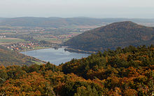
Rabenstein Gate

The Rabensteinpforte denotes the breakthrough of the Eder , west of the village of Affoldern in the north Hessian district of Waldeck-Frankenberg , from the Edersee trough to the east into the wide valley of the Wegaer Ederaue .
After its outlet from the Edertalsperre flooded in 1914 , the Eder winds around three kilometers first to the south and south-west and then in a sharp arc around the 338 m above sea level. NN high Blue Head to the east and then breaks immediately west of Affoldern, a district of the municipality of Edertal , south of the Blue Head and on the north slope of the 439.3 m above sea level. NN high Rabenstein into the wide plain of the Wegaer Ederaue and thus into the Wildunger depression (natural area 341.5).
The Affolderner See was created in the Rabensteinpforte in 1929 by damming the Eder , which was considerably enlarged twice in 1972 and 1998.
Coordinates: 51 ° 9 ′ 46.8 " N , 9 ° 4 ′ 40.8" E