Wahlebach
| Wahlebach | ||
|
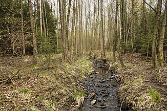
The Wahlebach above the Fahrenbachsteiche |
||
| Data | ||
| Water code | DE : 42954 | |
| location | in the district of Kassel and in Kassel ; Hessen ( Germany ) | |
| River system | Weser | |
| Drain over | Fulda → Weser → North Sea | |
| source | in the Söhre between the heads Belger 51 ° 14 '40 " N , 9 ° 37' 38" O |
|
| Source height | approx. 460 m above sea level NHN | |
| muzzle | in Kassel in the Fulda coordinates: 51 ° 19 ′ 2 ″ N , 9 ° 31 ′ 1 ″ E 51 ° 19 ′ 2 ″ N , 9 ° 31 ′ 1 ″ E |
|
| Mouth height | approx. 137 m above sea level NHN | |
| Height difference | approx. 323 m | |
| Bottom slope | approx. 19 ‰ | |
| length | 16.6 km | |
| Catchment area | 37.944 km² | |
| Left tributaries | see below | |
| Right tributaries | see below | |
| Big cities | kassel | |
| Communities | Söhrewald , Lohfelden | |
The Wahlebach (in the vernacular mostly just (the) Wahle and also known as Fahrenbach in the upper reaches ) is a 16.6 km long, eastern and orographically right tributary of the Fulda in the district of Kassel and in the independent Kassel , northern Hesse .
According to the Hessian Water Act as amended on December 18, 2002, the Wahlebach is a body of water III. Order .
course
The brook rises as Fahrenbach in the Kassel district in the Söhre . Its source is about 4 km (as the crow flies ) east-northeast of Wellerode (part of the municipality of Söhrewald ) between the Großem Belgerkopf ( 499.9 m above sea level ) to the north and the Kleinem Belgerkopf (approx. 490 m ) to the south at an altitude of about 460 m .
Initially, the Fahrenbach flows to the west and a little later feeds the 600 m² large extinguishing water pond in Department 63 of the Wellerode district with a creek without a name . The pond holds around 900 m³ of water, is around 1.80 m deep and is also called "Jeppe pond" because it was created during the service of the forester Dieter Jeppe.
Then the Fahrenbach flows through the three Fahrenbach ponds, which were first mentioned in 1585 at the time of Landgrave Wilhelm IV. As "Trout ponds near Wellerodt uffer Fahrenbach" or as trout ponds. The ponds, called the upper, middle and lower ponds, must be drained and fished every third year and are located about 2.5 km above the Welleröder church.
The dam crest of the ...
- upper pond is 351 m above sea level, the normal water level is around 350 m above sea level, the pond is drained by a monk (drainage device) whose wooden entrance was found in 2007 in a collapsed state; there is an overflow channel on the southeast side of the dam;
- The middle pond is 348 m above sea level, the normal water level is around 347 m above sea level, the pond has no drainage structures; there is an overflow channel on the southeast side of the dam; about at the level of this dam is a hut that invites you to rest;
- the lower pond is 344.5 m high, the normal water level is around 344 m high, this pond is also drained by a monk whose wooden entrance does not inspire confidence, which is why a warning is issued against entering (April 2007); there is an overflow channel on the northwest side of the dam.
Afterwards, the Fahrenbach flows through Wellerode, gradually leaving the forest area of the Söhre, where it bends to the north. The Rotebach coming from the south-east from the Trieschkopf ( 480.1 m ) and the Stellbachsgraben coming from the south from the Stellberg (approx. 495 m ) flow into the village . Below Wellerode, the Fahrenbach flows through Lohfelden - Vollmarshausen , after which it - henceforth called Wahlebach - turns to the northwest and flows through Lohfelden-Ochshausen.
Then the Wahle passes under the federal motorway 7 , which here forms part of the eastern city limits from Lohfelden to Kassel ; according to this, the brook itself represents a part of this border. Then the Wälzebach, which comes from the south and runs underground, flows into the Wahle on the border of the Kassel districts of Forstfeld and Waldau . In this area, the stream in Kassel runs on the shared borders of the districts of Forstfeld and Waldau, Bettenhausen and Waldau, and Bettenhausen and Untersteustadt . It crosses under other places such as Forstbachweg, Lilienthalstraße and in the area of the intersection Sandershäuser Straße – Söhrestraße – Leipziger Straße (near Hallenbad Ost ) Leipziger Straße ( Bundesstraße 7 ).
Finally, the Wahle opens into Kassel- Unterneustadt coming from the south east or directly below the port bridge (national roads 7 and 83 ) at about Fulda flow kilometer 27.25 to about 137 m height in the Fulda . Immediately to the north of the Wahl estuary is the Kassel district of Wesertor . The Ahne flows into the Fulda on this Fuldaufer directly above the harbor bridge .
The difference in altitude between the Wahlebach source and its mouth is approximately 323 m.
Catchment and precipitation area
The catchment area of the Wahle covers around 37.944 km² , the rainfall area is 39.83 km².
Tributaries
The tributaries of the Fahrenbach and Wahlebach stream include, viewed downstream, with orographic allocation (l = left-hand side, r = right-hand side), length of the water and its mouth with Wahlebach kilometers :
- Rotebach (l; 2.3 km), in Wellerode (to Söhrewald ; km 11.75)
- Stellbachsgraben (l; 2.05 km), in Wellerode (to Söhrewald; km 11.35)
- Wälzebach (l; 5.8 km), on the border of the Kassel districts of Forstfeld and Waldau (km 3.4)
History and hydrology
In Wellerode, the Fahrenbach was not only used as drinking and industrial water for humans and animals until the construction of water pipes around 1900. The water drove the upper and lower mill and was in addition also to irrigate meadows above the mentioned mills from the now eliminated or silted mill races as so-called "Sabbath rights", that is, from Saturday 18 to Sunday 18 pm Operating rest of the mills , utilized.
Within Vollmarshausen , the Wahlebach once ran parallel to Kasseler Straße past the judicial linden tree.
During the Second World War , on September 11, 1943, the municipal council approved the installation of dams in the Fahrenbach for fire-fighting purposes.
The wastewater from the neighboring communities of the Fahrenbach has been fed to the central sewage treatment plant in Kassel by the Losse-Nieste-Söhre wastewater association based in Kaufungen since 1979. The water quality of the then excessively polluted Fahrenbach then recovered by leaps and bounds to quality class II within 14 days.
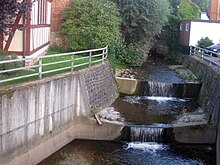
In the early 1970s, the election was straightened, especially in Kassel, and in 2005 (from September 12th ) it was extensively renatured within the city between the city limits ( A 7 ) and Nürnberger Straße ( B 83 ) .
Name interpretation
There is no reliable explanation of the name Fahrenbach. One interpretation refers to the fern that used to grow on its banks, the other to the common use of the river bed by carts in the past due to the lack of roads and suitable paths. The brook name changes during the course, which is also not unusual for other bodies of water from Fahrenbach in Wahlebach.
The name of a body of water is rarely unique. Two streams in the Werra-Meißner district are also called Fahrenbach. One has its source in the Kaufunger Wald am Langenberg, flows south and flows into the Gelster on the eastern edge of Großalmerode behind the Bunter Mühle , which flows into the Werra in Witzenhausen ; the other also rises in the Langenberg, but flows in a northerly direction through the small town of Witzenhausen-Fahrenbach and also flows into the Gelster just above Witzenhausen-Carmshausen. In the southern Hessian municipality of Fürth in the Bergstrasse district , a Fahrenbach also flows through the Fahrenbach district . In addition, the place name of the Baden Fahrenbach ( Baden-Württemberg ) indicates a body of water with the same name. Fahrbach is also used as a family name; In 2007 alone there were over 250 entries in the German telephone directory.
hike
The Fahrenbach ponds located below the Fahrenbach source area can be reached on foot from Wellerode, for example from the hikers' car park between the tennis courts and the Söhrekampfbahn sports field on Diebgrabenstraße via hiking trails 12/17 or from the parking lot at the end of Fahrenbachstraße via hiking trails 19/20. If you follow these paths to the old motorway bridge, which comes from a route planned in the German Reich for today's federal motorway 44 through the Söhre, they connect to form an approximately 3 to 4 km long circular path.
Individual evidence
- ↑ a b c d Water map service of the Hessian Ministry for the Environment, Climate Protection, Agriculture and Consumer Protection ( information )
- ↑ List of Economic State , Volume 2, p. 116
- ↑ Ludwig Zimmermann: The economic state , p. 116
- ↑ Hessisches Landesanstalt für Umwelt: Aquatic area directory Land Hessen , Wiesbaden, 1973
- ^ Decision log book of the municipal representation in Wellerode from April 2, 1898 to December 1933, p. 9
- ↑ Minutes of the consultation with the municipal councils from June 20, 1934 to December 19, 1944, p. 52
- ↑ moderately stressed; see Th. Hans-Dieter Scholz, and Culture on Foot - Hike through the Fahrenbachtal from Wellerode to Kassel-Bettenhausen , in: Söhrewaldbote , 11/94, pp. 13-19
- ↑ Th. Hans-Dieter Scholz: Everything here revolves around water. The Fahrenbachsteiche , in: Söhrewald 1984, pp. 311-314; Abwasserverband Losse-Nieste-Söhre in: as above, pp. 328–329; Fire extinguishing - Wellerode , in: as above, pp. 329-330; Söhrewald von AZ , Volume 1, p. 9 ff; Fahrbach , in: Söhrewald von AZ, Volume 1, p. 92; Fahrbachsteiche , Volume I, pp. 94-95


