
Vordertaunus
| Vordertaunus | |
|---|---|
 Overview map Taunus |
|
| Highest peak | Rossert ( 516 m above sea level ) |
| location | Hesse |
| part of | Taunus |
| Coordinates | 50 ° 10 ′ N , 8 ° 24 ′ E |
| Type | Low mountain range |
| rock | Phyllite , Greenschist and Serizite - Gneisses |
| surface | 218.90 km² |
The area or natural area south of the Hohe Taunus (301) is referred to as the Vordertaunus within the Hessian low mountain range Taunus (main unit group 30) . The corresponding natural area in front of the Taunus main ridge is also known as the Voraunus in regional studies .
geography
In contrast to the Hintertaunus , north of the settlement-free, wooded Taunushauptkamm, the Vordertaunus is a densely populated, metropolitan region. The built-up areas of the cities partially merge seamlessly or are only separated from each other by narrow, undeveloped strips (“regional green corridors”).
The development consists predominantly of typical suburban single-family and row houses . The settlement area is at an altitude between about 100 m above sea level. NN ( Maintaunus level ) and 400 m above sea level. NN , the higher slopes are almost completely occupied by forest.
The Vordertaunus includes the cities of the former Obertaunuskreis , i.e. the part of today's Hochtaunuskreis located south of the Taunuskamm ( Friedrichsdorf , Bad Homburg vor der Höhe , Oberursel (Taunus) , Steinbach (Taunus) , Glashütten , Kronberg im Taunus and Königstein im Taunus ) as well as the Towns and municipalities in the Main-Taunus district not located on the Main ( Eschborn , Schwalbach am Taunus , Sulzbach (Taunus) , Bad Soden am Taunus , Liederbach am Taunus , Kelkheim (Taunus) , Eppstein , Kriftel and Hofheim am Taunus ).
In a geographical sense, the city of Wiesbaden also belongs to the Vordertaunus, and the social structure in the districts on the southern slope of the mountains is quite similar to that in the communities mentioned, but in common parlance the term only refers to the western part of the Frankfurt "bacon belt" without the state capital .
The immediate vicinity of the Frankfurt city area makes the sunny southern slope of the Taunus a popular residential area for the upper class. Besides the south of Munich, the Vordertaunus is the richest region in Germany. The most expensive residential areas are u. a. Bad Homburg vor der Höhe, Kronberg im Taunus, Königstein im Taunus and Bad Soden am Taunus.
Bad Homburg is also the largest of the Voraunus cities and an important suburban center for the northern part of the Vordertaunus. The traditional center of the southern part is Frankfurt-Höchst , from where three regional and S-Bahn routes lead into the Vortaunus and where the parliament and district administration of the Main-Taunus district were located until 1987. Höchst itself, however, is on the Main, and its economic and resident structure cannot be compared with the municipalities mentioned.

Natural structure
The Vordertaunus (Voraunus) is naturally structured as follows.
- 300 Vortaunus (218.90 km²)
- 300.0 Rheingau-Wiesbadener Vortaunus (47.04 km²)
- 300.00 Rheingau-Vortaunus (28.00 km²)
- 300.01 Wiesbaden Vortaunus (19.04 km²)
- 300.1 Eppsteiner-Hornauer Vortaunus (101.66 km²)
- 300.10 Eppsteiner Horst (82.98 km²)
- 300.11 Hornauer Bucht (18.68 km²)
- 300.2 Altkönig preliminary stage (48.49 km²)
- 300.20 Königsteiner Taunusfuß (18.29 km²)
- 300.21 Kronberger Taunusfuß (30.20 km²)
- 300.3 Homburg Vortaunus (21.71 km²)
- 300.0 Rheingau-Wiesbadener Vortaunus (47.04 km²)

climate
In contrast to the cooler and more humid Hintertaunus, the area of the Vordertaunus has a favorable climate. The favorable climate of the Vordertaunus, the Main-Taunus plain including the Rheingau results from the opening of the area to the south and west. The Taunus foreland and the Rheingau are part of the Upper Rhine Plain , which continues in the Wetterau . The Taunus ridge, which presents itself as an open flank to the northwest and north, can be viewed as a kind of climatic divide, with the altitude above all exerting its influence.
The annual mean temperature in the Vordertaunus and Main-Taunusland is between 9 and 10 ° C. In a northerly direction towards the Taunus ridge, the temperature values continuously decrease with increasing altitude.
There is also a clear difference in the number of summer days . There are 35 to 55 summer days in the area south of the Taunus ridge. The average daily sunshine duration in the sub-areas south of the Taunus ridge is 7.4 to 7.5 hours.
The area from the Wetterau to the Upper Rhine Plain has more continental features, i. H. relatively dry summers and humid, milder winters. There is only about 550–600 mm of annual precipitation here . In the area of the higher Taunus slopes, in the Vordertaunus, they rise to 650–700 mm.
history
The Vordertaunus is an old cultural landscape with a traditionally high population density. The majority of the places were founded in the Frankish ( Carolingian ) times, i.e. in the 8th and 9th centuries. Most of the places that are still independent today were granted city rights in the Middle Ages (Homburg, Oberursel, Kronberg, Königstein, Eppstein and Hofheim) and can now boast an attractive townscape with their well-preserved old towns. In Kronberg , Falkenstein , Königstein and Eppstein there are medieval castles , the Homburg Castle was even until the middle of the 19th century residence of an independent state, the Landgraviate Hesse-Homburg . Administratively, most of the region belonged to Kurmainz in the early modern period and, after the Congress of Vienna, to the Duchy of Nassau , which fell to Prussia in 1866 and became part of today's State of Hesse in 1945 . The small towns and villages in the region lived mostly from agriculture, forestry and fruit growing (to this day, forests and orchards characterize the undeveloped part of the landscape).
But already in the late 19th century, Kronberg, Homburg and Königstein developed into popular villa suburbs in the fast-growing city. In 1852 a casino opened in Homburg , which, together with the railway connection that had existed since 1860, contributed to Homburg's rise to an internationally important spa town. Soden, which was already connected to the railway network in 1847, was one of the major European spas in the 19th century, as were the nearby cities of Wiesbaden and Bad Nauheim .
In 1858, students from the Städelschen Kunstinstitut in Frankfurt founded the Kronberg painters' colony , which also contributed to the upgrading of the Vordertaunus; some artists even settled in Kronberg for the rest of their lives. In 1868, Frankfurt nature lovers founded the Taunus Club on the Großer Feldberg , which is still one of the largest hiking clubs in Germany today.
The imperial family also supported this process: Wilhelm II chose Homburg Castle as his summer residence, his mother Victoria Kronberg Castle Friedrichshof as her widow's residence .
The development towards a densely built suburban landscape, albeit one of the most attractive of its kind, began with the onset of suburbanization around 1960, when, due to increased general prosperity and mass motorization, there was a great demand for homes “in the countryside” could previously be removed from the Frankfurt workplaces. Between 1960 and 1980, some of the Vordertaunus communities grew to three times their size. A certain saturation has been reached since the mid-1980s, the municipalities are only growing slowly, as only a few new building areas are being designated. However, the shortage of building land in this already sought-after residential area has led to ever increasing land prices; the rents in the Vordertaunus are now partially higher than those in Frankfurt's inner city districts.
traffic

All Vordertaunus communities have a connection to the Frankfurt S-Bahn or to the suburban trains of the Frankfurt-Königsteiner Eisenbahn (FKE). The Frankfurt U-Bahn also operates two routes operated by a former private railway company, the Frankfurter Lokalbahn , which run from Frankfurt-Heddernheim to Bad Homburg and Oberursel. In total, the city of Frankfurt and the Taunus suburbs are connected by eight rail lines. However, there are hardly any cross-connections between the Voraunus communities. This deficiency was to be remedied at the beginning of the 20th century by a monorail on the edge of the Taunus. However, the plans have not been implemented, and so has the Regional Tangent West project , which was supposed to create a rail link between the two sub-centers of Bad Homburg and Frankfurt-Höchst as well as the airport.
The rail routes from Frankfurt to the Vordertaunus were partly built very early: the Soden Railway as early as 1847, the Homburg Railway in 1860 and the Kronberger Railway in 1874. The nationally more important Main-Lahn Railway (via Hofheim to Limburg ), on the other hand, did not follow until 1877. The Königstein Railway was added in 1901. The Frankfurt local railway AG in 1899 opened a steam train from Oberursel to Hohemark and 1910 electric suburban trains from Frankfurt to Bad Homburg and Oberursel. More recently (1972) the Limes Railway to Schwalbach and Bad Soden was built. Trams also ran in Bad Homburg from 1899 to 1971 .
On the other hand, there are numerous possibilities for road traffic: The city highways A 661 (Bad Homburg / Oberursel area), L 3005 (Kronberg, Eschborn, Schwalbach area) and B 8 (Königstein, Kelkheim, Bad Soden area) lead to the city center of Frankfurt , The highways A 66 / A 5 at the "lower" and the B 455 at the "upper" edge of the urban area serve as efficient cross-connections , supplemented by parallels between them such as the L 3014 ("Limesspange") from Kelkheim to Eschborn or the L 3015 from Bad Soden to Oberursel.

The Neroberg in the Vordertaunus and the Taunushauptkamm near Wiesbaden
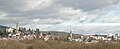
Kronberg im Taunus with castle


literature
- Reimer Herrmann: Comparative hydrogeography of the Taunus and its southern and southeastern peripheral areas. Wilhelm Schmitz Verlag, Giessen 1965, DNB 451978870 .
- Eugen Ernst: Hochtaunus Nature Park. ( HB nature magazine outside ). Hamburg 1983.
- Ingrid Berg, Eugen Ernst, Hans-Joachim Galuschka, Gerta Walsh: Heimat Hochtaunus. Frankfurt am Main 1988, ISBN 3-7829-0375-7 .
- Alexander Stahr, Birgit Bender: The Taunus - A journey through time. Borntraeger-Verlag, Stuttgart 2007, ISBN 978-3-510-65224-2 .
- Eugen Ernst: The Taunus - An L (i) worthwhile low mountain range. Frankfurt 2009, ISBN 978-3-7973-1146-7 .
Individual evidence
- ↑ Environmental Atlas Hessen of the Hessian State Office for Environment and Geology: Map of the natural areas of the Taunus Attention, web link without return, please open a new tab
- ^ Reimer Herrmann: Comparative hydrogeography of the Taunus and its southern and southeastern peripheral areas. Wilhelm Schmitz Verlag, Giessen 1965.
Web links
- Map services of the Federal Agency for Nature Conservation
- Environmental Atlas Hessen: Description of the natural areas of the Taunus Attention, web link without return, please open in a new tab