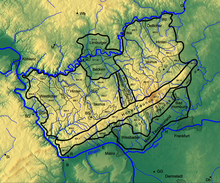
Main-Taunus foreland
As Main rope foreshore (main unit 235), the at Rhinegau subsequent to the east, the Mountain Taunus upstream edge of the hills to Oberrheinischen lowland counted Rhein-Main-lowland designated.
Natural location
In addition to the loess soils, which are also widespread here and which are heavily decalcified in places, tertiary layers play a part in the structure of this hill country. The Eppsteiner Horst, which protrudes from the Taunus, divides the Main-Taunus foreland into the Wiesbadener Taunus foreland to the west, with Wiesbaden Bay and Hochheimer Plain, and the northeastern Main-Taunus foreland with the Homburg Bay that projects against the Taunus.
The Taunus foreland, which sinks to the south and south-east towards the Main, is climatically characterized by a particularly early start of the vegetation period. Thermophilic beech forests, which used to be widespread, have given way to high-yielding arable and fruit growing. With this exposure and its spatial allocation to the conurbations of the Rhine-Main area, it is a preferred residential area. The associated heavy use of the landscape due to development already reveals significant changes in the natural balance since then, in particular the runoff regime. The occurrence of thermal and mineral springs ( Wiesbaden , Weilbach , Bad Homburg vor der Höhe ) deserves a mention.
Natural structure
The Main-Taunus foreland is structured naturally as follows:
-
(to D53 - Upper Rhine lowlands)
-
(to 23 - Rhein-Main-Tiefland)
- 235 Main- Taunus foreland (321.38 km²)
- 235.0 Wiesbaden Taunus foreland (129.26 km²)
- 235.00 Bay of Wiesbaden (51.39 km²)
- 235.01 Hochheimer Ebene (77.87 km²)
- 235.1 north-eastern Main- Taunus foreland (169.04 km²)
- 235.2 Homburg Bay (23.08 km²)
- 235.0 Wiesbaden Taunus foreland (129.26 km²)
- 235 Main- Taunus foreland (321.38 km²)
-
(to 23 - Rhein-Main-Tiefland)
The Environmental Atlas Hessen divided often also projected the Taunus foothills Hornauer Bay which is just east of the Eppsteiner Horst hugs, designated at Schwenzer with the area code 235.2, with the code 300.11 the Vortaunus to.
Individual evidence
- ↑ Map and legend (Rhein-Main-Tiefland) - Attention: Web links without return! - Environmental Atlas Hessen of the Hessian State Office for Environment and Geology: The natural areas of Hesse and their main units
