Randstad
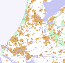
The Randstad is a metropolitan area in the west of the Netherlands with a total population of eight million people. This area was defined by the Dutch Ministry of Housing, Spatial Planning and the Environment as part of a spatial development plan and is specifically promoted.
The Randstad includes the urban areas of and around Amsterdam , Haarlem , Leiden , The Hague , Delft , Rotterdam , Dordrecht , Gouda , Utrecht , Hilversum and Almere . The area therefore extends over parts of the provinces of Noord-Holland , Zuid-Holland , Flevoland and Utrecht . The Randstad accounts for 20 percent of the total area and more than 40 percent of the population of the Netherlands.
The term Randstad (German: Randstadt, Saumstadt, Kantestadt) was first used in 1938 by Albert Plesman , founder and director of the Dutch airline KLM , after seeing the region from the air. The cities of the Randstad are located along the edge of the Green Heart of the Netherlands with a gap in the southeast, forming a sickle shape. The cities are a minimum of 26 km (The Hague - Rotterdam) and a maximum of 77 km (Amsterdam - Rotterdam) apart.
With a gross regional product of 216.3 billion euros, this region, the economic heart of the Netherlands, ranks fifth behind London , Paris , Rhine-Ruhr and Milan in a European comparison . As part of the blue banana , it is part of Europe's largest agglomeration.
Web links
- The Randstad and the "Green Heart" (regional studies school project of the University of Münster )
supporting documents
- ↑ Pim Kooij, Paul van de Laar: Rijksuniversiteit Groningen (PDF)
- ↑ Mirko Ellrich: Info sheet Economic Areas in Europe - The Blue Banana. In: Klett.de , February 25, 2014.

