Rossel (Saar)
| Rossel | ||
|
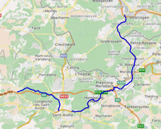
Course of the Rossel |
||
| Data | ||
| Water code | DE : 2644, FR : A95-0200 | |
| location |
France
|
|
| River system | Rhine | |
| Drain over | Saar → Moselle → Rhine → North Sea | |
| source | near Longeville-lès-Saint-Avold 49 ° 8 ′ 16 ″ N , 6 ° 36 ′ 36 ″ E |
|
| Source height | approx. 322 m | |
| muzzle |
Saar bei Völklingen - Wehrden Coordinates: 49 ° 14 ′ 45 " N , 6 ° 50 ′ 23" E 49 ° 14 ′ 45 " N , 6 ° 50 ′ 23" E |
|
| Mouth height | approx. 196 m above sea level NN | |
| Height difference | approx. 126 m | |
| Bottom slope | approx. 3.3 ‰ | |
| length | 38 km | |
| Discharge at the Geislautern A Eo gauge : 203 km² Location: 3.3 km above the mouth |
MNQ MQ Mq MHQ |
1.39 m³ / s 2.36 m³ / s 11.6 l / (s km²) 15.7 |
| Left tributaries | Lauterbach | |
| Right tributaries | Schafbach (FR) | |
| Medium-sized cities | Völklingen | |
|
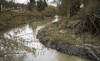
The Rossel at Petite Rosselle (on February 21, 2016) |
||
The Rossel (French: Rosselle ) is a left-hand tributary of the Saar . It rises about two kilometers north of the village of Longeville-lès-Saint-Avold in the Grand Est region and flows into the Saar after 38 kilometers at Völklingen - Wehrden . The medieval Rosselgau and the towns of Groß- and Kleinrosseln are named after the Rossel .
geography
course
The Rossel rises between the Lorentzberg and the Steinerecken , east of the village of Boucheporn , at an altitude of 322 m . It flows first in a northeasterly direction past the Pfaffenloch . In Grosswald , where the up Dripperchenquelle is, she suggests a gentle curve, turns its course to the east-southeast and then squeezes through a narrow wooded valley. It runs southwest past the Cité Émile Huchet settlement in the municipality of Freyming-Merlebach and changes direction there to the south. At Saint-Avold -Oderfang it is fed by the Muehlegraben on the right side . East of the drilling mill , it makes a sharp curve to the north and crosses under the N 3 . It heads west and, accompanied by the N 3, passes Saint-Avold. At Moulin Neuf , the Rosselbach , which comes from the south, flows to you on your right . At Moulin a Poudre , where it is strengthened by the Maimahdbach , it turns north and digs through a narrow valley until it reaches Hombourg-Haut . It passes the village and takes on the Katharinenbach on the eastern edge of the village . At the intersection of the N 3 with the A 4 , it crosses under the N 3, which it now leaves and turns its course to the west. It is now accompanied by the A4 for a short distance. At the A 4 / A 320 motorway triangle , the Dotelbach coming from the south falls to her . It now bends around Forêt de Ditschviller and flows south past Cité Belle Roche . At the eastern edge of the village it is fed by the Kochernbach . It now directs its course to the north and flows west past Rosbruck and the Gaensbachwald , where it reaches the French-German border. Here the Morsbach flows into it. At Marienau (Forbach) and Emmersweiler, municipality of Großrosseln, the river changes sides several times before it forms the border between the two states for almost three kilometers at Großrosseln / Petite-Rosselle. At Cité Quatre Vents , the Schafbach reaches it before it finally crosses the border into Germany . It now flows around Großrosseln-Velsen on the eastern edge and then reaches Völklingen- Geislautern , where the Lauterbach strengthens it. At Völklingen-Wehrden it finally flows into the Saar at an altitude of 196 m .
Tributaries
- Muehlegraben ( Blindengraben ) ( right ), 7.1 km
- Ruisseau de Dourd'Hal ( right ), 2 miles
- Maimattbach ( right ), 3.5 km
- Katharinenbach ( Ruisseau de Ste-Catherine ) ( right ), 3.6 km
- Dotelbach ( right ), 3.3 km
- Merle ( left ), 9.0 km
- Kochernbach ( Ruisseau de Cocheren ) ( right ), 8.1 km
- Morsbach ( right ), 6.1 km
- Muhlbach ( right ), 2.1 km
- St. Nikolaus Bach ( left ). 3.3 km
- Kressbrunnenbach ( left ), 0.7 km
- Großrosselner Bach ( left ), 2.5 km
- Schafbach ( right ), 2.0 km
- Eberbach ( right ), 1.0 km
- Lauterbach ( left ), 8.2 miles
- (Bach from) Hohlbergquelle, 1.1 km
- Hallerkopfbach ( right ), 0.4 miles
Hydrology
At the Geislautern gauge, just before the confluence of the Rossel in the Saar , the mean flow rate (MQ) is 2.36 m³ / s; the catchment area there covers 203 km².
In Petite Rosselle, the average annual runoff of the Rossel was calculated over a period of 41 years (1966–2006) . The catchment area at this point is about 190 km².
The flow rate of the Rossel , with an annual average of 1.89 m³ / s, fluctuates very little over the course of the year. The highest water levels are measured in the winter months from December to March. The flow rate reaches its peak in February at 2.53 m³ / s. In April the discharge decreases and changes little until October. It reached its lowest level in September with 1.5 m³ / s, after which it rose again slightly from month to month and after the strong increase in December reached its second highest level with 2.48 m³ / s.
The monthly mean discharge (MQ) of the Rossel in m³ / s, measured at the Petite Rosselle hydrological station.
Data calculated from the values for the years 1966 - 2006

pollution
For a long time the river was one of the dirtiest bodies of water in Germany . The wastewater from the mines and coking plants in particular from Forbach and Freyming-Merlebach and the chemical platform Carling in Carling - Saint-Avold , all on the French side, flowed into it - completely unexplained for decades .
Individual evidence
- ↑ a b c d e f g h Self-measurement on the GeoPortal Saarland
- ↑ Banque Hydro - Station A9532010 - La Rosselle à Petite-Rosselle (menu item: Synthèse)
Web links
- Literature on the river Rossel in the Saarland Bibliography
- Geislautern gauge (PDF file; 23 kB)
- Débits caractéristiques de la Rosselle (French; PDF file; 14 kB)
- Rosselle at SANDRE (French)

