
Ensdorf (Saar)
| coat of arms | Germany map | |
|---|---|---|

|
Coordinates: 49 ° 18 ' N , 6 ° 47' E |
|
| Basic data | ||
| State : | Saarland | |
| County : | Saarlouis | |
| Height : | 200 m above sea level NHN | |
| Area : | 8.39 km 2 | |
| Residents: | 6466 (Dec. 31, 2019) | |
| Population density : | 771 inhabitants per km 2 | |
| Postal code : | 66806 | |
| Area code : | 06831 | |
| License plate : | SLS | |
| Community key : | 10 0 44 123 | |
| Address of the municipal administration: |
Provincial Street 101a 66806 Ensdorf, Germany |
|
| Website : | ||
| Mayor : | Jörg Wilhelmy (independent) | |
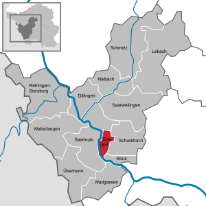
| Location of the municipality of Ensdorf in the Saarlouis district | ||
  |
||

Ensdorf is a municipality in the Saarlouis district , Saarland . Ensdorf is on the right bank of the Saar .
history
Stone ax finds show that in the area of today's Ensdorf community as early as around 2000–1000 BC. Chr. People lived or at least stayed. The place name Ensdorf is probably derived from the Celtic word "Anisa" for "swamp". What is meant here is a swampy location on the banks of the Saar.
The historians have recognized and accepted April 11, 1179 as the verifiable first mention of the place . This date comes from a letter of protection from Pope Alexander III. with the same date. In it he certifies, in addition to the possessions of the Wadgassen Abbey , an “Allodium Boemundi” that was located in “Enstorff”. Under Allodium a heritage is to be understood. It is believed that a man by the name of Boemund inherited or donated this genetic material to Wadgassen Abbey. The current name Ensdorf was only documented uniformly from the 17th century.
.jpg)

Remnants of military roads , the former Roman fort in Lenten and the fertile plain with the Lisdorfer Au are evidence of a strong fluctuation, at least in the first centuries. Good craftsmen and fertile fields, as well as the Saar with its abundance of fish and the possibility of cargo shipping, were reasons for a settlement. At the end of the 17th century, village life in the municipality increasingly developed towards agriculture and handicrafts. The mining , a new emerging profession in addition to the iron and steel works, offered the male population sources of income and wealth.
After the Saar area after 1815 by France to Prussia had been assigned, the community developed within a short time from a purely agricultural village to a flourishing craft, trade and industrial center. Its importance is underlined by what was once the most powerful mine in Europe, the Duhamel mine , the VSE AG power plant and the numerous medium-sized companies.
On January 1, 1974, Ensdorf was initially assigned to Schwalbach / Saar due to a regional reform. However, the citizens were able to reverse this through their massive protests. Since January 1, 1982, Ensdorf has been an independent municipality in the Saarlouis district again.
politics
mayor
- 1816–1849: Philipp Müller
- 1850–1851: Mathias Mungen
- 1851–1857: Jakob Schwan
- 1857–1880: Georg Sarg
- 1880: Mr. Pohl
- 1880–1885: Major Minor
- 1885-1892: Mr. Karitta
- 1892: Christoph Röner
- 1893–1896: Michel Pohl
- 1897-1919: Wilhelm John
- 1919–1934: Max Ruff
- 1935–1945: Heinrich Zell, NSDAP
- 1945–1946: Michel Schmitt, SPD , (provisional)
- 1946–1948: Wilhelm Motsch
- 1948–1955: Benedikt Ochs
- 1955–1956: Josef Puff
- 1956–1960: Josef Becker, CDU
- 1960–1974: Franz-Josef Schleimer, SPD
- 1974–1982: Edgar Spies, CDU , (mayor at the time of the Schwalbach community)
- 1982–1996: Alfons Schorr, CDU
- 1996–2012: Thomas Hartz, CDU
- 2012–2019: Hartwin Faust, CDU
- since 2019: Jörg Wilhelmy, (independent)
Municipal council
The council with 27 seats is made after the local elections on May 26, 2019 as follows:
- CDU 11 seats
- SPD 7 seats
- Green 4 seats
- Free voters 4 seats
- Left 1 seat
Community partnerships
Ensdorf maintains an official partnership with the French communities of Wizernes and Hallines as well as a friendship with the Bavarian community of Ensdorf .
coat of arms
The coat of arms of the municipality of Ensdorf shows a silver heraldic lily in a red field above the silver wave shield river, floating over a golden mallet and iron, from which a silver lightning flashes to the left and right. The silver wave suggests that Ensdorf is located on the Saar and is functionally connected to it. As the most important industrial company on the municipal ban is the Ensdorf mine, which is at the forefront of Western European hard coal mining with its performance, the mining symbol mallet and iron occupies a central position in the coat of arms; the fact that it appears in gold should once again underline the economic importance of mining for Ensdorf in the color emphasis. The lightning bolts point to the Ensdorf power plant. The silver lily is a symbol of Mary and refers to the fact that Ensdorf belonged to the Wadgassen Abbey until 1581 , whose church was dedicated to the Mother of God. The lily is also a symbol of the French kings and illustrates the historical ties with France through the former membership of the Saarlouis ban. Since the place became part of the Duchy of Lorraine after 1581 , silver, red and gold appear in the coat of arms as the colors of the Dukes of Lorraine . The coat of arms was awarded on November 22, 1963.
Culture and sights
Buildings

- Marian pilgrimage site Hasenberg with sculptures, mosaics, fountains and a chapel by various artists
tourism
The Ensdorfer Bergehalde is a ~ 100 m (~ 380 m above sea level) vantage point with a hiking trail.
In the middle of 2005 the art project "Art on the Halde" of various Saarland artists was exhibited. In 2016, the Saarpolygon landmark was built on the mine dump to commemorate the end of mining in Saarland.

.jpg)
Sports
The most famous club in town is the football club (FC) Ensdorf . In the 1970s and 1980s, the football club - at times in the Oberliga Südwest - experienced its greatest successes. In the 1973/74 season, FC Ensdorf even played for one season in the Regionalliga Südwest , the second highest division in German football at the time. The club has a grass and hard court.
Economy and Infrastructure
Industry: hard coal mining , coal power plant . The Ensdorf mine was with around 4,000 employees one of the largest in Germany. It extracted around 3.5 million tons of high-quality steam coal per year from particularly conveniently located seams. Since 2005, however, coal mining has repeatedly caused light to moderate tremors, which led to growing protests from the affected population. On February 23, 2008, there was a mountain impact with a magnitude of 4.0 on the Richter scale , which led to considerable damage to the surface around Saarwellingen . The coal mining was then temporarily stopped; a resumption of production from the rich seams in the Primsmulde is not to be expected. Until 2012, around a third of the previous funding volume had been achieved in smaller seams (Grangeleisen, Wahlschied); the coal age in the Saar district finally came to an end in mid-2012.
traffic

The breakpoint Ensdorf (Saar) is located on the Saar Railway Saarbrücken-Trier. Ensdorf can also be reached via federal highway 51 .
education
Day care centers
- St. Marien Ensdorf day care center
primary school
- Elementary School Ensdorf
Community school
- Johannes Gutenberg School Schwalbach
Personalities
Sons and Daughters of the Church:
- Peter Altmaier (* 1958), politician (CDU)
- Herbert Martin (1925–2016), national soccer player (Saarland) 1950–1956
Web links
- Ensdorf municipality
- Literature on Ensdorf (Saar) in the Saarland Bibliography
- Link catalog on the subject of Ensdorf / Saar at curlie.org (formerly DMOZ )
Individual evidence
- ↑ Saarland.de - Official population figures as of December 31, 2019 (PDF; 20 kB) ( help ).
- ↑ Bernhard Kirsch: Why is the Saar called "Saar" or who was there before the Celts? in: Our home, newsletter of the Saarlouis district for culture and landscape , 41st year, issue No. 2, 2016, pp. 45–56, here pp. 48–49.
- ↑ a b Federal Statistical Office (ed.): Historical municipality register for the Federal Republic of Germany. Name, border and key number changes in municipalities, counties and administrative districts from May 27, 1970 to December 31, 1982 . W. Kohlhammer, Stuttgart / Mainz 1983, ISBN 3-17-003263-1 , p. 808 .
- ↑ Oranna Dimmig: Art Lexicon Saar, Kunstort Hasenberg Ensdorf / Saar , ed. from the Institute for Current Art in Saarland, Saarbrücken 2014, pp. 9–12.
- ↑ Deutschlandradio, February 26, 2008
- ^ Municipality of Ensdorf: Municipality of Ensdorf | Day care centers. Retrieved June 19, 2018 .
- ↑ a b Municipality of Ensdorf: Municipality of Ensdorf | Schools. Retrieved June 19, 2018 .
Bous | Dillingen / Saar | Ensdorf | Lebach | Nalbach | Rehlingen-Siersburg | Saarlouis | Saarwellingen | Enamel | Schwalbach | Overlord | Wadgassen | Catfish catch