Easter (Blies)
| Easter | ||
|
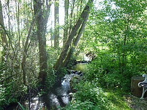
The Easter in May 2012 in Oberkirchen |
||
| Data | ||
| Water code | DE : 26422 | |
| location | Germany | |
| River system | Rhine | |
| Drain over | Blies → Saar → Moselle → Rhine → North Sea | |
| source | near Oberkirchen 49 ° 31 ′ 42 ″ N , 7 ° 14 ′ 25 ″ E |
|
| Source height | approx. 453 m above sea level NN | |
| muzzle | in Wiebelskirchen in the Blies Coordinates: 49 ° 22 ′ 20 " N , 7 ° 11 ′ 17" E 49 ° 22 ′ 20 " N , 7 ° 11 ′ 17" E |
|
| Mouth height | approx. 243 m above sea level NN | |
| Height difference | approx. 210 m | |
| Bottom slope | approx. 6.8 ‰ | |
| length | 30.7 km | |
| Catchment area | 53.061 km² | |
| Discharge at the Hangard A Eo gauge : 112 km². Location: 3.75 km above the mouth |
NNQ (07/03/1976) MNQ 1963/2012 MQ 1963/2012 Mq 1963/2012 MHQ 1963/2012 HHQ (12/21/1993) |
50 l / s 191 l / s 1.54 m³ / s 13.8 l / (s km²) 26.6 m³ / s 54.7 m³ / s |
| Left tributaries | Dünkelbach, Selchenbach, Bubach | |
| Right tributaries | Wilmesbach, Betzelbach, Lautenbach | |
The Oster is an almost 31 km long, north-eastern and left-hand tributary of the Blies in the Palatinate Bergland in the north-eastern part of the Saarland .
course
The Oster rises in the Saar-Hunsrück Nature Park , a little west-northwest of Oberkirchen . It flows from the Osterquelle , which lies southeast of the Füsselberg and northwest of the Mittelberg, the northern foothills of the Weiselberg .
Initially, the Oster, which is accompanied by the Ostertalbahn to Fürth , runs eastwards to Oberkirchen and then flows through this place, where it is crossed by the Oberkirchen viaduct , to the south. From then on, the stream continues in this direction to Hoof and then along the B 420 via Marth and Niederkirchen to Werschweiler , where it leaves the Saar-Hunsrück Nature Park . Then it flows over Dörrenbach and Fürth to Hangard .
Finally, the Oster, which is now flowing westwards on its last kilometers of stream, flows into the Blies , which comes from the north , after a difference in altitude of 210 m in Wiebelskirchen .
history
After it was straightened over long stretches in the 1930s, 1960s and 1970s, the Oster has been renatured in sections since 1990. From 1934, the Ostertalbahn, named after him, was built along the stream .
Individual evidence
- ↑ Saarland surface water body lengths (PDF; 72 kB)
- ↑ GeoExplorer of the Rhineland-Palatinate Water Management Authority ( information )
- ↑ State Office for Nature, Environment and Consumer Protection North Rhine-Westphalia (Ed.): German Hydrological Yearbook Rhine Region, Part III . ISSN 0170-9976 (annually). ( Single sheet at the Hangard Level 2012, on: Umweltserver.saarland.de, PDF, German, 15.9 kB)
- ↑ a b c d data on Easter according to environmental server.saarland.de ( memento of the original from January 12, 2009 in the Internet Archive ) Info: The archive link has been inserted automatically and has not yet been checked. Please check the original and archive link according to the instructions and then remove this notice.
