
Jewish cemetery (Dillingen / Saar)

The Jewish cemetery Dillingen / Saar is a Jewish cemetery on the outskirts of the Diefflen district of the city of Dillingen / Saar in the Saarlouis district in Saarland . It is designated as an architectural monument .
description
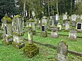
The cemetery , the largest Jewish cemetery in Saarland, is located on the edge of the Hüttenwald forest on Dillinger Straße. About 470 tombstones have been preserved.
history
Jewish burial places
The Jewish cemetery in Dillingen / Saar was the burial place for all places in the area with the exception of Saarwellingen . In 1746 the high Lorraine official Charles Francois Dieudonné de Tailfumyr, Seigneur de Cussigny et Président à Mortier, bought the Dillingen estate. He was a baptized Jew and showed his Jew-friendly policy by the permission granted in 1755 to create a Jewish cemetery on the edge of the Dillinger Forest on the Dieffler border in an area of approx. 90 ares. The initiative came from the Saarlouis Jews Hayem and Zerf von Worms and Elias Reutlinger, who had to pay an annual interest of 25 Lorraine francs for it. In the same year 1755, the first deceased were buried.
A list of burials (name, place of residence, date of burial, gender, cause of death, age) is available for the period from February 27, 1882 to September 1, 1936. The list includes 345 people.
Probably at the beginning of May 2011, one or more unknown perpetrators desecrated the Jewish cemetery. 19 gravestones were overturned and eight other graves were significantly damaged. The stones partially broke. Marble writing plates were destroyed at eight other graves. Officials of the Dillingen police station started investigations after the fact was discovered by workers from the city of Dillingen and secured the crime scene. The State Security Department of the State Criminal Police Office also started investigations. Incised signs, graffiti or other perpetrator confessions were not left behind.
- Jewish cemetery in Diefflen, views of gravestones

Diefflen, Jewish cemetery

Diefflen, Jewish cemetery

Diefflen, Jewish cemetery

Diefflen, Jewish cemetery

Diefflen, Jewish cemetery
Diefflen, Jewish cemetery

Diefflen, Jewish cemetery

Diefflen, Jewish cemetery

Diefflen, Jewish cemetery

Diefflen, Jewish cemetery


The list names 36 places of origin of the buried.
- Beaumarais: 21
- Beckingen: 4
- Bettingen: 13
- Bibergen (Bibiche in Lorraine): 1
- Büren (since 1937 Siersburg): 9
- Buprich: 4
- Diefflen: 8
- Differten: 4
- Dillingen: 28
- Frankfurt am Main: 1
- Fraulautern: 11
- Felsberg: 5
- Fremersdorf: 2
- Fürweiler: 2
- Groß-Hemmersdorf: 3
- Kerprich-Hemmersdorf: 14
- Hüttersdorf: 10
- Ittersdorf: 1
- Itzbach: 5
- Lebach: 4
- Lisdorf: 1
- Merzig: 1
- Metz: 1
- Nalbach: 28
- Niedaltdorf: 20
- Püttlingen: 1
- Rehlingen: 17
- Clearing: 14
- Saarbrücken: 2
- Saarlouis: 51
- Siersdorf: 9
- Steinbach: 2
- Talfangen (Thalfang): 1
- Völklingen: 2
- Wadgassen: 3
- Catfish catching: 22
The place of origin is missing for 20 dead.
In 1852 the cemetery was enlarged. It was destroyed in 1938 during the Nazi era . It was restored in 1946.
Nazi slave labor cemetery


In 1964, a burial place for over 50 Polish, Russian and one Croatian slave laborers from the Nazi era was created in the rear part of the cemetery. The memorial stone bears the inscription "Homeless and abandoned, they found their final resting place in strange earth."
In 2009, the commitment of the city of Dillingen to the restoration of the entrance portal was honored with the Saarland Monument Preservation Prize in the "Public Owners" group.
See also
literature
- Katharina Best: The history of the former synagogue communities of Dillingen and Nalbach, in: Our homeland, bulletin of the Saarlouis district for culture and landscape, 13th year, issue 3/4, 1988.
- Stefan Fischbach, Ingrid Westerhoff: "... and this is the gate of heaven", Synagogues Rhineland-Palatinate and Saarland, ed. from the State Office for the Preservation of Monuments in Rhineland-Palatinate, State Conservator Office of the Saarland, Synagogue Memorial Jerusalem, Mainz 2005 (Memorial Book of Synagogues in Germany 2), pp. 108–115.
- Hans Peter Klauck: Jewish life in the city and in the district of Saarlouis 1680-1940, Saarlouis 2016.
- Aloys Lehnert: History of the City of Dillingen / Saar, Dillingen / Saar 1968, pp. 640–643.
- Albert Marx: The History of the Jews in Saarland, From the Ancien Régime to the Second World War, Saarbrücken 1992.
- Wolfgang Meyn, Michael Lintz, Andrea Bock: Jewish cemeteries in Saarland, ed. from the Circle of Friends for the Rescue of Jewish Cultural Property in Saarland e. V. and from the State Conservatory Office of the Saarland, Saarbrücken o. J., pp. 36–37.
- Werner Müller: The Jewish minority in the Saarlouis district, political, socio-economic and cultural aspects of their living situation from the Ancien Régime to National Socialism (writings of the Saarlouis district, volume 1), St. Ingbert 1993.
Web links
- Dillingen. In: Overview of all projects for the documentation of Jewish grave inscriptions in the area of the Federal Republic of Germany; here: Saarland (editor: Felicitas Grützmann).
- Dillingen / Diefflen (Saarlouis district) - Jewish cemetery on alemannia-judaica.de
- Dillingen-Diefflen Jewish Cemetery (especially photos) (PDF; 4.5 MB) at mpg-saarlouis.de
- The renovation of the cemetery is finished, Saarbrücker Zeitung dated December 14, 2009.
- Digital Edition - Dillingen-Diefflen Jewish Cemetery (1787–1974 / 479 entries) (full documentation / as of March 21, 2011).
Individual evidence
- ↑ Dillingen in the list of monuments of the Saarlouis district ( Memento of the original from December 14, 2013 in the Internet Archive ) Info: The archive link was automatically inserted and not yet checked. Please check the original and archive link according to the instructions and then remove this notice. PDF, 150 kB, accessed on January 22, 2010.
- ^ Dillingen in the overview of all projects for the documentation of Jewish grave inscriptions in the area of the Federal Republic of Germany / Saarland, alphabetical list , accessed on January 22, 2010.
- ↑ Ludwig Petry (ed.): Handbook of the historical sites of Germany . Volume 5: Rhineland-Palatinate and Saarland (= Kröner's pocket edition . Volume 275). Kröner, Stuttgart 1959, DNB 456882898 , p. 77.
- ↑ http://www.alemannia-judaica.de/dillingen_sls_friedhof.htm , accessed on March 8, 2020.
- ^ Aloys Lehnert: History of the city of Dillingen / Saar. Krüger, Dillingen / Saar 1968, pp. 640–643.
- ↑ Saarbrücker Zeitung from July 16, 2009.

Coordinates: 49 ° 22 ′ 7.5 ″ N , 6 ° 45 ′ 9.6 ″ E