
Diefflen
|
Diefflen
City of Dillingen / Saar
|
||
|---|---|---|
 |
||
| Height : | 185–250 m above sea level NHN | |
| Area : | 5.04 km² | |
| Residents : | 4593 (Dec. 31, 2019) | |
| Population density : | 911 inhabitants / km² | |
| Incorporation : | 1st August 1969 | |
| Postcodes : | 66763, 6638 | |
| Area code : | 06831 | |
Location of Diefflen in Saarland |
||
.jpg) Diefflen, view of the town center with the church of St. Josef and St. Wendelin , on the left the Dillinger Hütte , behind it the transmission masts of the Felsberg-Berus transmitter ( Europe 1 ), in the background the church of the ridge of the 359 m high Limberg on the far bank of the Saar
|
||

.jpg)
.jpg)
.jpg)
.jpg)
.jpg)
Diefflen (High German pronunciation: Dieflen; in the local, Moselle-Franconian dialect Dejfeln ) is a village and a district of Dillingen / Saar in the Saarlouis district ( Saarland ) and has about 4700 inhabitants. It lies on the lower Prims , a tributary of the Saar . Since its foundation in the High Middle Ages , Diefflen has been a historical part of the upper court of the Nalbach Valley . Also in terms of its soft appearance , Diefflen has merged with the old town of Nalbach and its Bierbach and brickworks settlements. In 1969, when it became part of the city of Dillingen / Saar, the town left the previous municipal association.
geography
Physical-geographical classification


.jpg)
Diefflen is part of the Hunsrück foreland and thus the Saar-Nahe mountainous region and the Lorraine stepland , the easternmost section of the Paris basin . Characteristic for the Saar-Nahe-Bergland is a structure of areas at different altitudes, which are cut up by larger valleys with associated side valleys. The areas are partially separated from each other by distinct steps. At the beginning of the Tertiary about 65 million years ago, today's area formed a slightly undulating plain that hardly differed from the Variskan hull of the Rhenish Slate Mountains . At that time the room was only a little above sea level. It was then highlighted today in several phases.
In the area of the Saar-Nahe-Bergland, Diefflen belongs to a spur of the central Saar valley, which penetrates the Saarlouis basin in a north-easterly direction and ends in the Prims-Blies hill country. The lower reaches of the Prims, with its confluence with the Saar, form a valley with a wide floodplain and very flat terraces.
The Prims is the largest tributary of the Saar from the Devonian Hunsrück region . In its lower reaches, the Prims has created a wide valley from Körprich down in the softer upper Kuseler strata and the coarse-grained Vosges sandstone. It left behind mighty gravel and clay terraces in the extensive confluence of the Saar. The wide valley floors, which extend from an imaginary line between Litermont and Steinberg on both valley flanks to the southwest, are inclined towards both the Prims and the Saar. The valley flanks were only created in the outermost estuary by the erosion of the Saar. The mighty erosion masses of rubble, sand and clay were moved by the Ur-Prims with their parallel brooks (Lochbach, Rodener Bach, Kondeler Bach, Beckinger Bach or their predecessors) to the southwest towards the Saar and thus helped to determine the course of the Saar.
In the Saarlouis valley widening, the Saar valley is filled with large masses of gravel over a length of around 15 km and an average width of 2 km. During foundation measures in connection with bridge construction in the first third of the 20th century in Wallerfangen (1927), Fraulautern (1929), Dillingen (1933), as well as railway construction and river regulations near Dillingen, the solid red sandstone was only reached at a depth of 6 m. These erosion masses cannot be ascribed to the Saar, as it only has a gradient of 0.36 ‰ here. Likewise, the left tributaries of the Saar are not possible causes.
The cause of this strong gravel in the Saar valley by the primordial prims is presumably a stronger uplift of the clod of the east wing on the central Saar towards the end of the Tertiary . The Saar slid to the west on the right, more steeply inclined floe and created steep impact slopes on the left, less inclined Triassic plate , such as B. the Wallerfanger Saarengt. The Ur-Prims must therefore be thought of as a river with a steeper gradient than is the case today. In the Diluvium, the water-rich primordial prims exerted strong pressure on the course of the Saar river from the east and forced it to move partly to the west due to the deposition of erosion material. On the Limberg (358.9 m) and the Hoesberg (325.7 m) left of the Saar, traces of old river beds can still be seen. At that time the Saar flowed in the Altdiluvium south of Itzbach, turned around the Itzbacher Königsberg (344, m) to the north and flowed via Eimersdorf into today's Saar valley. It took the Nied to the west of Büren.
The pebbles of the Prims consist mainly of vein and fissured quartz , quartzites , quartzite slates, pebble slate, Permian pebbles , sandstones, conglomerates from the Rotliegend , porphyries and melaphyres . The characteristic Prims gravel can also be found on the Saar terraces. In diluvial and alluvial times, the huge masses of debris built up the river bed more often and shifted the mouth into the Saar several times. The steep slope at the foot of the Dillinger Forest and in Dillinger Strasse in Diefflen has only recently been developed, from which the Prims has withdrawn again. This relocation of the Primsbett is due to the development of the local erosion base of the Prims, i.e. the Saar at the mouth of the Prim. Due to the incision of the Saar after the last Ice Age, the Prims had to follow the law of regressive erosion accordingly. This regressive erosion has lowered the Ice Age deposits of the prims in the lower reaches by 4 to 5 m. The backward erosion development of the Prims has currently advanced about 12 km up the Prims starting from the Prim's mouth and has reached approximately the height of the confluence of the Theel in the Prims.
The settlements of the lower Primstal (Piesbach, Bilsdorf, Nalbach, Diefflen, Dillingen) were all built on the flood-free lower terraces of the Prims or the associated mountain slopes. The gradient of the prims decreases continuously from the origin, where it is still 20 ‰. Below Körprich the Prims only has a gradient of approx. 2 ‰. After multiple ramifications in the Nalbach-Dieffler valley widening, the Prims near Dillingen reaches the Saar at a height of 173.5 m. In order to reduce the danger of the constant threat of flooding, the river in the broad valley was often dammed by artificial regulation of the Primsbetten and the mouth was relocated several times down the river to the north. In the first third of the 20th century, oak trunks 6 to 10 m in length and more than 1 m in diameter were exposed on diluvial gravel during primary grading measures near Nalbach, Diefflen and on the Dillinger Hütte site in the sole terrace. These finds can be interpreted as evidence of the violence of the formerly raging Prime River or as stoppers of man in historical times.
Assuming the correctness of the thesis put forward by the geographer Johann Jakob Reichrath that the red sandstone slope in the Nalbacher Straße (Nalbacher Kirchenweg) and the Dillinger Straße once formed the right bank of the Prims in prehistoric times, the Dieffler Dorfbach ( fed by the "Schlungenbach", the "Obersten Bach" and the "Augrätbach") at that time it flowed into the Prims at an approximately right angle in the area of the Petersberg below the Zipp. The relatively sharp slope edge of the Petersberg should support this assumption. Due to the higher flow speed of the Prims, their greater erosion power and their larger amount of sediment carried along, the confluence of the Dorfbach was likely to have shifted the confluence of the Dorfbach to the west over time, so that the Gräth of the Dieffler Dorfbach widened like a funnel. The center of this rinsed valley triangle would be today's Dieffler Dorfplatz between Weilerstrasse and Beckinger Strasse / Düppenweilerstrasse. When the river bed of the Prims then increasingly shifted southwards into its current valley floodplain, the original confluence of the Dorfbach could have been so filled with sediments that it flowed westwards through today's Dillinger Straße and probably only in the area of today's “In der Gaul ”to the south, towards Prims, deflected.
Geological-geomorphological situation

The geological subsurface of Diefflen is the middle red sandstone . The red sandstone is the oldest rock package of the Triassic and the outermost edge of the Paris basin. The petrographic composition of the Dieffler Buntsandstein is medium-hard to sandy, which guarantees a free circulation of the groundwater. The red sandstone is therefore an important groundwater carrier, which like a giant sponge has high storage capacities for water. It is reddish in color and free of fossils. This suggests that it was formed under continental conditions as a deposit in shallow river valleys or embankment in shallow inland lakes. The climatic conditions when it was created approx. 220 million years ago are comparable to today's dry, subtropical climate.
The red sandstone weathered to form nutrient-poor, light sandy soils, which are not very favorable for agricultural use and which historically remained largely forested. In contrast to the forest stands on the basic soils of the shell limestone (Saargau), the soils of the red sandstone are more acidic, so that hornbeams and hardwoods settle less strongly. Instead, birch and pine also appear. A mixed oak forest with beeches is characteristic of the lower forest areas, with the beech gaining the upper hand as the altitude increases. The closedness of the forest was broken up by people where younger, tertiary sediments such as alluvial loam were deposited on the red sandstone. This happened up to the geological present on both sides of the lower valley section of the Prims.
To a lesser extent, the red sandstone in Diefflen is on the surface; It is covered to a far greater extent by the Pleistocene and Holocene deposits of the Saar and Prims , which originally flowed here. These deposits belong to a large sedimentation body , which is triangular in plan, whereby the corner points can be described by the location of Saarlouis , Beckingen and Bilsdorf . Diefflen as part of the Saarland was never glaciated during the ice ages. However, the Saar and Prims were only able to transport their erosion material, which fell in large quantities under the climatic conditions of the cold ages, to a limited extent, so that it was accumulated on wide valley floors. During the intervening warm periods, Saar and Prims each cut their way back into their old valley floors.
Both the sedimentation body and the subsurface underneath were changed in the course of the Quaternary by the forces of weathering and erosion. This ultimately led to the room being characterized by horizontal surfaces on the one hand and slopes on the other. The areas appear as the banks of the river terraces dating from the Prämindel to the Würm and as the leveling of the Prims floodplain. The slopes include the flanks of larger and smaller valleys and the walls of young erosion gorges ("Gräthen"). The areas are proportionally the dominant spatial element; their share is around four fifths. Diefflen is divided into three zones: the floodplain as part of the Lower Primstal spatial unit, the slope and ridge zone and the plateau of the Dieffler terrace slabs.
Floodplain
The Prims lowland (208 to 186 m), through which the river flows in numerous, mostly straightened and built-up meanders, is nine kilometers long and one to two kilometers wide. It differs from the similar type of Saar lowlands in particular by the stronger coarse gravel and scree guides. The gravel was and is being mined in numerous pits that remain as flooded quarry pits . Due to the groundwater accumulation in front of the actual alluvial cone of the Prims, most of the naturally regularly flooded valley floodplain is boggy and is occupied by low-yielding meadows interspersed with alder and birch trees . Numerous loamy-sandy alluvial cones line up beneath the heavily ravaged, 50 m high red sandstone steep slope of the Dieffler terrace slabs. They are partly taken up by garden and farmland.

Diefflen, Prims, downstream towards Dillingen

Diefflen, Primsrausch
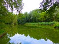
Diefflen, pond in the floodplain zone

Diefflen, pond in the floodplain zone with the Dieffler church tower in the background

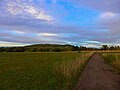
Diefflen, Weg in der Auenzone
.JPG)
.JPG)
.JPG)
.JPG)
.JPG)
The Dieffler Primsauenzone is bounded in the west, south and east by the lines that separate the district of Diefflen from the districts of Dillingen , Roden , Saarwellingen and Nalbach . In the north the border runs between the red sandstone and the lower terrace, the latter being part of the floodplain. The course of the borders gives the floodplain the shape of a square, its length from east-south-east to west-south-west approx. 1.6 km and its average width from north-north-west to south-south-east 0, 9 km. The area is 1.44 km². In relation to the total demarcation area of 5.04 km², the floodplain zone has a percentage of 27.7.
The floodplain is at an altitude of between 190 and 185 m above sea level. The northern border runs in the area of the 190 m isohypse ; the southern limit reaches values from 186 m to 187 m. At the eastern border there are values of 190 m, the western border is at an altitude of 185 m.
The Prims flows through the floodplain in its southern half from east to west. On its way through the floodplain, the river overcomes a height difference of approx. 5 m. A straight course results in a gradient of 5 m per 1.6 km (= 3.125 m / km). Without artificial regulation (dam construction, lowering of the water table), the Prims would be a meandering river with several floodplains per year.
Slope and ridge zone
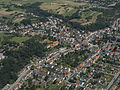
Diefflen, aerial view from the southwest; The wooded and bushy strips mark the slope and ridge zone

Diefflen, slope and ridge zone, Gewann "Auf der Obersten Bach", hall 4, looking south to the Gewann "Auf der Scheib", hall 5

Diefflen, slope and ridge zone, won "On the uppermost stream", looking north, hallway 4

.JPG)
.JPG)
The slope and ridge zone comprises 20.8% of the Dieffler district area. It consists of three separate sub-complexes. From north to south follow one another:
- the slope that slopes down to the Kondeler Bach
- the upper Hainbachtal
- the northern slope of the Primstal and the ridges attached to it
The slope area at the Kondeler Bach falls from the 240 m isohypse to the north or to the northwest to the Kondeler Bach down to 205 m above sea level. The average gradient is 12-13% (i.e. 6 °). The slope was created by cutting the Kondeler Bach into the plateau.
The upper Hainbachtal is also an erosion notch in the plateau and runs from northeast to southwest. Its lowest point within the Dieffler district is 220 m. There is a 40 m wide flood plain here. The northwest slope has a slope of 60 °. This corresponds to 133.3% if a 45 ° incline is set at 100%. The slope of the other valley flanks is around 20%.
The area of the northern slope of the Primstal with the ridge connected to it is closed in the south by the border line to the floodplain. The south-facing slope of the Primstal was created in the late Pleistocene by river erosion. The prims cut into their own gravel and into the red sandstone below. The slope body is cut in two places. This happened after the prims were deepened at the floodplain level. As a result, the rainwater coming from the plateau had to regulate itself to the deeper erosion base and thus created the two notches in the west and in the center. The material released from the plateau was carried away by the water and formed alluvial fans that dovetailed with the lower terrace of the Primsaue.
Plateau zone
The plateau zone of the Dieffler district and the adjoining terrace slabs of the districts Dillingen, Pachten and Nalbach are referred to in geographic research as "Dieffler terrace slabs". The terrace slabs are dominated by the Litermont and form fairly flat and largely wooded areas, which are divided longitudinally and transversely by deeply cut box valleys and gorges and drop steeply to the Saar-Prims valley. At 230 to 250 m above sea level, they are about 60 m above the valley floor and consist of a gravelly sandy terrace body, which is covered in the eastern part below the 414 m high liter monte by mighty decking loams. These loams were mined, processed and burned by several brick factories until the 20th century .
The base of the steeply sloping base is the main red sandstone. The southern boundary, strongly ravaged by deep cracks in the slope, is a terrace ledge (225 to 240 m). The slope cracks (ridges) are linked with alluvial cones and extend far up to the plate. Against the gusset of the mouth of the Prims and Saar, the “Pachten heads” (240 and 230 m high, on the Pachten district) are pushed forward as steeply sloping ridges and separated by a stepped, asymmetrical valley. The result of recent soil erosion is the moor-like long valley of the Kondeler Bach, which rises on the northern slope of the Litermont, which is sunk by 50 m and filled with alluvial sand. The northern Dieffler Terrassenplatte borders with a 60 m high, notched and steep slope lined with Voltziensandsteinkuppen to the " Haustadter Tal", which is dominated by the steep ascent of the Merzig Muschelkalkplatte.
The ecological value of the Dieffler terrace slabs differs depending on the proportion of the watering clay. The clay coverings are gently hollowed in by swampy valley origins, largely free of forests and interspersed with individual settlements (Nalbach districts "Ziegelei" and "Bierbach", Dieffler district "Siedlung"). The arable land, rich in orchards, rated as good with 40 to 59, remains largely uncultivated as a land expected to be built. Deep cutting and forest cover begin where the clay layer is thinned. The arable land numbers are to be set at 20 to 39. Young afforestations with spruce , pine and larch predominate on the partly plowed, lightly clay-covered sedge and on the dry valley floors . The red sandstone slopes are populated by tall beeches and oaks . These connected forest complexes are located as a recreational area between the industrial conglomerations of Dillingen and Beckingen. The former forest area on the Pachtener Köpf (Pachtener Heide) that was cleared in modern times has been developed for residential development since the 1960s.
In the vicinity of the Dieffler sports airfield, where intensive sand and gravel mining is carried out, up to 15 m thick layers of gravel and sand from the Pleistocene are stored . The sands on the light, crumbly sandstones of the Middle Buntsandstein are red-brown in color. The terrace area corresponds to the D-horizon described by the geographer Friedrich Fischer in 1957. The deposits are structured cyclically and contain three paleo soils , two of which developed on activated loess . The geographer Ludwig Zöller sees the stratification of the soils of the plateau area deposited by the prims as representing four cold periods and four warm periods . According to paleomagnetic measurements, the maximum age of the sediment layers is said to be less than the Matuyama-Brunhes limit , i.e. less than 690,000 years. In sandy and silty horizons are periglazial resulting cryoturbations present.

Diefflen, view from the Zipp
Diefflen, plateau with a view of the Litermont

Diefflen, plateau zone with a view of the Litermont, former gravel mining area, "Rosselstein" district, corridor 4

Diefflen, plateau zone, district "Rosselstein", former gravel mining area, The row of trees in the background marks the Graethenzone in the district "Auf der Obersten Bach", corridor 4

Diefflen, plateau, litter fruit meadows with cattle farming
Diefflen, plateau, litter fruit meadows with cattle farming
.jpg)
.JPG)
.JPG)
.JPG)
.JPG)
.JPG)
The plateau zone has a share of 51.5% of the municipal area. It ends in the west and east at the municipal boundaries, otherwise it is enclosed by the border lines of the slope and ridges zone. The plateau can be divided into two levels. It is several meters of gravel from the Saar and Prims. The lower level is in the area of 225 m above sea level and is attributable to the Riss cold period . The upper level begins at 240 m above sea level and belongs to the Old Pleistocene, which means that the gravel is dated as at least Glacial and older. The plateau reaches a height of over 250 m in the north and northwest and drops from this height to the southwest and south to approx. 225 m.
Large parts of the plateau have a layer of clay resting on the gravel body , the thickness of which varies from a few centimeters to over two meters. During heavy rain or snowmelt, the surface water collects in flood areas, some of which give off their water via deeply sunk, elongated dents, so-called "sinks". The sinks get their moisture not only from direct precipitation, but also from water that penetrates the gravel bodies from the Litermont over a long period from a north-easterly direction. The Litermont towers over the plateau by approx. 160 m. It delivers part of its excess water to a rubble zone on its southwest flank. From there, the water mostly reaches the gravel packets of the plateau underground. So even more humid physiotopes can exist here even after weeks of drought . The Litermont adjoining the plateau zone is a remnant of a volcanic intrusion , a magma effusion in crevices and layer joints. This intrusion of porphyry cast rock with larger crystal intrusions of feldspar and quartz was later exposed.
Historical-anthropogenic space character

.jpg)
The area around Diefflen has been used by humans since prehistoric times . The natural spatial unit of the Prims-Blies hill country shows a moderate to partly favorable settlement favor. The settlement of the central Saar area probably began in the Neolithic . The heart of the area was the Moselle region around Metz. From here the Prims-Blies hill country was settled. Although no tangible artefacts have been made on the floor of the local mark, the evidence from the neighboring markings indicates that the Dieffler district was also a possible living and economic area. The uniform forest cover of the Prims-Blies hill country was overcome in Roman times.
When Diefflen was founded in the Middle Ages as a hamlet, which received manorial and ecclesiastical directives from Nalbach, the floodplain was ruled out as a settlement due to partial swamp and the threat of flooding. The new settlers decided to build the hamlet in the slope and ridge zone, where the slope that bounds the Primstal has its central incision. For the location of the new settlement area on Petersberg, the fact that the middle red sandstone is pending on the steep slope that follows may have been significant. It is suitable for the construction of rock cellars . With an entrance building, these rock cellars could also have been used for residential purposes (semi- troglodythism ). The new hamlet was located in such a way that a distance of 0.8 km each had to be covered to the west and east to the boundary of the district. The distance to the south was about 1 km. In the north it was a maximum of 3 km. The supply of water for humans and animals was ensured by wells that were dug into the red sandstone interspersed with dammed layers of lettuce , and by the village stream that flowed through the new settlement. Due to its high groundwater level, the floodplain zone was not used for fruit growing. The plateau was preferred as a grain growing area.
Today Diefflen is part of the Saar agglomeration. In the valley of the lower Prims, Diefflen forms a section of an almost closed settlement lane, which is made up of the locations of the historic Nalbach valley.
The entire area of the Nalbach Valley is divided into corridors. The district of Diefflen, which belonged to the Nalbach Valley until 1969, comprises 10 corridors. The center of the village is in hall 6. In total, the municipality of Nalbach had 49 hallways before 1969. Since Diefflen was incorporated into the city of Dillingen / Saar, there are only 39 corridors left.
Historical route guidance
.JPG)
The Nalbacher Tal was probably already crossed by an important traffic route that led from the Moselle to the Rhine in the Bronze Age (around 2200 to 800 BC) . The path connected most of the Celtic settlement centers of today's Saarland with their fortifications and their princely graves. Within today's Saarland, it led from Merten via Wallerfangen through the Nalbach Valley. From the confluence of the Theel into the Prims , he followed the right bank of the Theel to Theley . Here the path forked to the so-called Hunnenring from Otzenhausen , to Rheinheim , as well as to Freisen and Schwarzerden . Today's main axis in Diefflen is based entirely on this route that has been in place since the Bronze Age.
The new hamlet of Diefflen was or was connected to the three spatial units (floodplain, slope and ridge zone, plateau) and the neighboring communities for the purpose of goods transport. It is not known whether the most important connecting lines were newly created during the expansion period or whether they essentially already existed. It can be assumed that Pfaffenweg and Nalbacher Straße (historic Kirchenweg) were already laid out. The Pfaffenweg was possibly already in use in Roman times.
The Nalbacher Straße at the foot of the distinctive land step (Auf der Zipp, Am Beienberg, Bei den Seven Eichen) was probably an agricultural connection between the village of Nalbach and the agricultural and forestry areas of today's Dieffler Bann even before the hamlet of Diefflen was founded. Continued in a westerly direction, the Nalbacher Kirchenweg is the connecting road to Dillingen. The path line of Dillinger Straße and Nalbacherstraße follows the red sandstone country step completely, so that the historical building line running below the slope edge had to do without adequate usable space behind the houses, while the houses on the other side of the street did not yet in terms of the expansion of their immediate economic area through the regulated prims and the associated soil moisture were restricted.
Parallel to this connecting road running from east to west between Nalbach and Dillingen via Diefflen, the Pfaffenweg runs over the plateau at a distance of approx. 1 km. Both paths, Pfaffenweg and Kirchenweg, are oriented towards the age-old Mainz - Metz connection line , which crossed the Saar at Lachten ( Contiomagus ). One of these two Dieffler routes may have been part of the trade route from the Rhine to the Moselle in Lorraine . In the basic pattern of the two traffic routes, cross connections were later added in the area of the Diefflen district. Such cross-connections have to apply:
- the now out of service Düppenweilerweg as the shortest connection between Dillingen and Düppenweiler,
- Düppenweiler Street, which connects the center of Diefflen with the plateau and leads to Düppenweiler,
- Beckinger Straße, which reaches the plateau from the center of Diefflen and runs in the direction of Beckingen,
- as well as the Düppenweilerstraße coming from Nalbach.
All of these cross-connections reach the plateau via moderately steep slopes. The land step bordering the Primstal was unsuitable due to its steepness and the ridge was out of the question as a main route to be fortified because of its narrowness and the danger of erosion there.
The Dieffler Auenzone is accessed through the Wiesenstrasse. The path initially runs over a red sandstone tongue projecting into the floodplain and then tries to reach the Prims in a direct line. At the point where the Prims and Wiesenstrasse meet, the river was not crossed by ford or bridge, but the path runs parallel to the Prims downstream. Only in the southwest of the Diefflens district does the path cross the Prims at a shallow spot and then continue towards Roden. In the Roden district, the path meets a presumed Roman road system, an old salt path that, coming from the Lorraine saltworks area around Moyenvic and Marsal , led through the Primstal on the left side of the river to the Rhine. Saarwellingen can also be reached from the meeting point with this presumed old salt road.
Neighboring communities
.JPG)
The Dieffler municipal area borders on the following municipal areas:
| City of Dillingen / Saar (district Pachten , district Pachtener Heide) |
Community Beckingen (Beckingen district) |
Municipality of Nalbach (districts of Bierbach / Ziegelei) |
| City of Dillingen / Saar (Dillingen city center district) |
.svg)
|
Municipality of Nalbach (district of Nalbach) |
| City of Dillingen / Saar (Dillingen city center district) |
City of Saarlouis ( Roden (Saar) district ) |
Saarwellingen municipality (Saarwellingen district) |
climate
The climate in Diefflen is warm and temperate. There is significant rainfall throughout the year. Even the driest month still shows high rainfall. The annual average temperature is 9.7 ° C. The precipitation falls on average within a year 724 mm. The lowest precipitation with 48 mm falls in April. In contrast, August is the wettest month of the year with 71 mm of precipitation. In terms of temperature, July is the warmest month with an average temperature of 18.2 ° C. With an average of 0.9 ° C, January is the coldest month of the whole year. The precipitation varies 23 mm between the driest month and the wettest month. With regard to temperature, the average values fluctuate around 17.3 ° C over the course of the year.
|
Climate table Diefflen
Source: Klima: Dillingen / Saar , climate-data.org, accessed on January 10, 2016
|
|||||||||||||||||||||||||||||||||||||||||||||||||||||||||||||||||||||||||||||||||||||||||||||||||||||||||||||||||||||||||||||||||||||||||||||||||||||||||||||||||||||
history
For the history of Diefflen, its local Moselle Franconian dialect, its traditional south-west German Querheinhaus house form and its former costume see:
politics
coat of arms
.jpg)
As a district, Diefflen also has the coat of arms of the city of Dillingen / Saar .
- The blazon of the coat of arms
A silver, tinned and grooved wall on a blue background, above a silver, gold-crowned and gold-armored eagle with outstretched wings and a red tongue. In the wall there is a golden gate with a red border. On it a red zigzag bar, which is surmounted by a three-legged, blue tournament collar . The coat of arms colors "red and gold" of the old Duchy of Lorraine and the Lorraine rulership of Siersberg-Dillingen are used as the city colors.
See also:
mayor
- Mayor of Diefflen until it was incorporated into Dillingen on August 1, 1969
| Terms of office | mayor |
|---|---|
| 1845-1859 | Johann Reuter |
| 1859-1867 | Johann Jakob Schamper |
| 1867-1870 | Bernhard Scherer |
| 1871-1872 | Peter Reuter-Scherer |
| 1873-1879 | Nikolaus Weyand |
| 1880-1886 | Peter Scherer-Marx |
| 1887-1893 | Peter Bach-Senzig |
| 1894-1899 | Nikolaus Scherer |
| 1900 (resignation from the mayor's office in Fraulautern on January 1, 1900; establishment of the mayor's office in Nalbach) –1918 | Johann Scherer-Schamper (until March 1918) |
| 1918-1918 | Johann Bellmann-Zenner (until December 1918) |
| 1919-1920 | Johann Scherer-Schamper |
| 1920-1922 | Johann Albert Brutty ( SPD ) |
| 1922-1926 | Jakob Wagner-Bach (SPD) |
| 1926-1930 | Johann Dittgen-Kunz ( center ) |
| 1930-1935 | Peter Reiter-Scholer (center) |
| 1935-1940 | Hermann Greilach ( appointed as local mayor by the NSDAP without prior election ) |
| 1940-1945 | Johann Feld (appointed as local mayor by the NSDAP without prior election; in charge of official business as first deputy since September 1938) |
| 1945-1946 | Peter Baumann (appointed as a communist by the US occupation forces without prior election) |
| 1946-1949 | Johann Scholer-Diwo |
| 1949-1950 | Jakob Lorang-Bach |
| 1950-1953 | Jakob Jost-Kunz ( CVP ) |
| 1953-1956 | Josef Spurk ( CVP ) |
| 1956-1960 | Willi Dräger |
| 1961-1965 | Hans Meiers |
| 1965-1968 | Nikolaus Friedolin Domma |
| 1968-1969 | Hans Ring |
Parish hall

Diefflen, parish hall after the renovation work in 2012; before that, the section of Nalbacher Strasse, which was added to the newly created village square in the 1980s

Diefflen, corner of Nalbacher Kirchenweg (today Nalbacher Straße) / Düppenweilerstraße; The village fountain of Oliberius is located at the place of the inn on the left; At the place of the courtyard on the right edge of the picture is today the parish hall (photo taken around 1900)

.jpg)
The Diefflen parish hall on Dillinger Strasse, built in the 1950s, is a hall for cultural and social events. The main hall (hall: 270 m², stage: 45 m²) offers 288 seats with concert seating. The former mayor's administration rooms and the former council chamber of the formerly independent municipality of Diefflen are located on the upper floor of the parish hall. There is a restaurant on the ground floor.
education
Day care centers
There are two facilities available in Diefflen to look after small children:
.jpg)
- "Kinderinsel Diefflen" (kindergarten, day care center and crèche)
- Catholic Kindergarten St. Josef (kindergarten and day care center)
School development
.JPG)
.JPG)
.jpg)
In 1618 Wilhelm Marzloff von Braubach ordered the establishment of a school with a schoolmaster in the Nalbach Valley.
"Item it should generally be considered by the gentlemen on a qualified Scholmeister who should be used in all and relevant cases before a common clerk, who should get order before his salarium (wages) pro qualitate from the officials."
The schoolmaster was supposed to teach the children of the entire Nalbach valley as well as to act as community and court clerks and to be remunerated according to performance. In a list from 1623, a Cornelius Noper is named as a "Ludimagister" (elementary school teacher). Noper was also a host in Nalbach. School operation was limited to the winter, as the children had to help their parents on the farm during the rest of the time. During the Thirty Years War this school facility went under. Only for the year 1708 is there a Ludimagister named Friedrich Meyer in the death registers of the Nalbach parish of St. Peter and Paul . His successor in office Johann Martin Reichard calls himself "Schoolmaster of the Nalbach Valley". Like his predecessor in office, Reichard was also a community clerk. For the year 1739 two classrooms are recorded for Nalbach. However, the parents seem to have handled their children's schooling very negligently, so that police ordinances had to threaten defaulting parents with fines. Likewise, the police ordinance for the villages of the Nalbacher Valley of June 6, 1726 points to this obvious grievance:
“The subjects should diligently send their children to school, but if they do not, they should not only pay school fees to the teacher from the usual time of the day, but instead should be viewed with another punishment of a gold guild. "
In an ordinance of the Bishop of Trier from the year 1737 it is criticized that in the parishes of the Landkapitels Merzig, for extremely understood reasons of economy, less qualified teachers, even vagrants, were employed as teachers, since they demand less wages than the really competent teachers. In this regard, the Trier ordinance admonishes pastors to put an end to such abuses. For the year 1759 the Nalbacher church books record a Petrus Spanda and for the year 1784 a Petrus Willmuth as Ludimagister. In the year 1787 a Paulus is called lamps. All these Nalbach teachers did not come from the Nalbach valley, but had moved from outside the country.
In the wake of the reorganization of the French Revolution , schools were set up in all sub-communities in the Nalbach Valley, but these were of a makeshift character compared to today's conditions. Until the second half of the 19th century there were entries in the Nalbach registry office registers about people, especially women, who were not able to enter their names on their own when signing.
With the transition of the Nalbach Valley to the Kingdom of Prussia in 1816, compulsory schooling was officially introduced. In 1818 the first teachers' seminar was set up in Trier and parish school inspectors were appointed. For the mayor's offices on the right bank of the Saar, this was Pastor Matthias Kimmer from Nalbach. Paulus Lamps, who was now called Paulus Lamp, took over the Nalbach parish school. The director of the Dieffler school was Paul Kiefer in 1819. In Körprich, Nikolaus Puhl, who was trained in the Trier seminar, taught in a small house below the Michaelskapelle. In Bilsdorf Peter Scholer led the lessons and in Piesbach-Bettstadt Johannes Spurk. All community schools were single class and had only one teaching post. In view of the precarious financial situation in the first half of the 19th century, the villages of the Nalbach Valley were unable to build new school buildings. Compulsory schooling began at the age of seven or eight and ended at the age of ten or eleven. It was not until 1867 that it was ordered that children under the age of 14 were required to attend school. The winter schools have also been canceled.
Kirchenweg schoolhouse
In Diefflen, school lessons were given in the old Wendelinus chapel in Kirchenweg (today Nalbacher Strasse) until a new schoolhouse was built in Wiesenstrasse (today the location of the Diefflen fire station). The school was single-class until 1858 and had 176 students at that time.
Schoolhouse Wiesenstrasse

The slate-roofed schoolhouse, built in 1863, had two full floors and an attic and was designed in a mixture of classicist and neo-Gothic styles. It had five window axes on its eaves side as well as a dwarf gable with an entrance portal and three window axes on its two gable sides. The portal and windows of the central projectile were adorned with bow roofs. In the center of the gable field, a round window with a bow roof opened. On the left side of the gable of the school building there was a fire brigade attachment. In 1899, more than 300 students were admitted to the school building on Wiesenstrasse, so that lessons even had to be given in converted stables.
School building on Dillinger Strasse
Due to the increased number of pupils, construction of a school building on Babelsberg in Dillinger Strasse began in 1902. In 1912 it was expanded by six classes. The school building from the 1860s on the corner of Wiesenstrasse and Richard-Wagnerstrasse served as a kindergarten for a long time until it had to give way to the current fire station in 1959/1960. A new kindergarten had been built on the neighboring property on Richard-Wagner-Strasse.
Richard-Wagner-Strasse school building
In 1962/63 the community of Diefflen built a large new school building with two classroom wings, an administration building with student toilets, a covered break hall, a gym with outdoor sports facilities and an inner courtyard according to the plans of the Dillingen architect Konrad "Conny" Schmitz Arboretum on Richard-Wagner-Strasse. The school was given the name "Primsschule". A second, larger sports hall with a grandstand was added to the building by 1983.
In 1970 the Dieffler Hauptschule was closed and grades 5-9 were outsourced to the Dillinger Odilienschule. The vacated rooms were immediately given a new use:
Due to the strong growth in the number of students at the Dillinger Gymnasium (in 1973 to over 2100 students; thus one of the numerically strongest high schools in Germany), the entire wing II of the new school building in Richard-Wagner-Straße and the entire old building of the former elementary school in the Dillinger Straße am Babelsberg used as a high school building.
Only with the construction of a branch of the grammar school in Dillinger Karcherstraße (and the takeover of a wing of the former Protestant elementary school also in Karcherstraße), which was completed in 1982/1983, the grammar school relocated its operations entirely to Dillingen. The school building on Babelsberg was demolished in the 1980s and replaced by an extensive residential and hotel complex.
Infrastructure and economy
railroad
The next passenger and goods station is the Dillingen (Saar) station, which opened in 1858 . It is a railway junction on the Saar line of the Deutsche Bahn (Saarbrücken-Trier-Koblenz) with the branch of the Niedtalbahn to Thionville in France and the Primstalbahn .
According to the plans of the municipal councils in 1888, the Dillingen-Primsweiler railway line was originally intended to run on the right bank of the Prims via Dieffler municipality. It was supposed to connect the Trier-Hermeskeil-Wemmetsweiler and Trier-Saarbrücken railway with a cross section. However, the railway administration decided on a route on the left side of the Primate. Construction work began in 1897 and was completed by 1901. The closest train station to Diefflen was Nalbach. At the same time, the Dillingen station was expanded, provided with a railway underpass and promoted from class II to class I, as Dillingen was now the most important junction on the Saarbrücken-Trier line. In June 1980 passenger traffic on the route through the Primstal was stopped. Freight traffic continues to run along the route as required. On the part of the Dillinger Hütte premises that is on the Dieffler district on the left-hand side of the Primate, there are six tracks that serve rolling mill 2.
Transportation
In 1913 were district Saarlouis seven electrically powered tram lines ( Electrical road and narrow-gauge railways in the district Saarlouis ) built. The company ran the railway construction company Becker & Co GmbH in Berlin , which had also carried out the construction. One of these tram lines ran from Saarlouis to Dillingen and a second from Dillingen via Diefflen to Nalbach . The municipal council decided to build the tram in 1907 because Diefflen had not been taken into account when the railway was built. After the canalization of the village streams, the tracks were laid and on October 10, 1912, tram operation was introduced on a trial basis. The official commissioning took place on October 18, 1913. Since 1928 there has been a bus route from Diefflen to Düppenweiler . In the period from 1953 to 1963 the company switched from tram to bus operation, with buses from French manufacturers being replaced by German buses from 1960.
The entire municipal area (including Dillingen and Lachten) is now networked and connected to the surrounding area by eight bus routes operated by the Saarlouis roundabout company, which was founded in 1913 . There are also five rail bus routes.
Road traffic
Diefflen is connected to the national and international trunk road network via several motorway junctions: The junctions Dillingen-Mitte (No. 8) and Dillingen-Süd (No. 10) are on the A 8 . Diefflen is also connected to the A 620 via the Saarlouis motorway triangle (No. 9) in between . In 1953, a concrete bridge was built over the Prims instead of the old ford.
Airports in the vicinity
.JPG)
.JPG)
There are several airports within a 100 km radius of Diefflen:
- Saarbrücken Airport
- Luxembourg-Findel Airport
- Hahn Airport in Hunsrück
- Zweibrücken airfield
- Saarlouis-Düren airfield as a traffic landing pad for private planes
- Glider airfield and airfield for powered flight in Diefflen
The Luftsportclub Dillingen / Saar eV was founded in 1965. It emerged from the glider division of the "Luftsportfreunde Saarlouis / Dillingen", which had to move to the Saarlouis-Düren airfield due to the construction of the Ford works on the Röderberg in Saarlouis. Until 1972, there was no airfield in the Saarwiesen near Dillingen.
In 1971 the construction of today's airfield and the aircraft hangar in Diefflen began. In order to level the site, a former sand and gravel mining area was filled with 360,000 m³ of filler material. The airfield created in this way has a length of 800 m and a width of 120 m. It was put into operation on October 1, 1972. Just one year later, the 1,000th launch was registered. After the runway for glider pilots was extended to the east in 2003, it reached the length approved in 1972. From 1988 the hangar was expanded to include a training building.
post Office


Napoleonic period
In 1813, on the orders of Emperor Napoleon, the first optical state telegraph line in Germany (route Metz-Mainz, line length 225 km) was built according to the Claude Chappe system and put into operation on May 29, 1813. A telegraphic connection from Paris to Mainz was thus possible. The signal line ran across today's Dieffler municipality. The signaling stations surrounding Diefflen were the Siersberg and the Litermont . The next stop was the Hoxberg . With the three wooden signal bars, 196 characters could be formed in good weather. The signal system on the liter mount was probably on a wooden scaffolding. For the 1050th anniversary of the municipality of Nalbach, planning began on the construction of a stone signal tower on the Litermont, based on the model of the signal tower at the Alsatian castle Hohbarr near Zabern . The signal bars are made of metal for better weather resistance.
Prussian conquest
With the Prussian conquest of the area on the left bank of the Rhine under Gebhard Leberecht von Blücher , the signal line was interrupted and a short time later telegraph operations were completely stopped. When the Nalbach Valley was assigned to the Kingdom of Prussia by the Congress of Vienna , the complex fell into disrepair.
Royal Prussian period
On August 3, 1816, the provisional district administrator of the newly founded district of Saarlouis Jakob Christian Schmeltzer reorganized the postal system for Diefflen and sent mail carriers with administrative mail through the district twice a week. Private mail was also sent, but due to high illiteracy rates and a lack of demand, this remained within narrow limits. On April 30, 1838, the riding post on the Saarlouis-Trier route was discontinued. In 1846 the Landbrief ordering institute was launched. The postmen were active on certain days of the week, from 1865 on all weekdays except Sundays. The mail route Saarbrücken-Trier ensured that the post office carried passengers from Dillingen.
After the opening of the railway in Dillingen, the "Postexpedition Dillingen" (2nd class) was opened on January 20, 1858. Now a country post coach drove every day as a single horse-drawn cart with box body from Dillingen via Diefflen to all places in the Nalbach Valley to carry mail and people.
Since July 1, 1891, when a post agency opened in Nalbach , mail was transported from Dillingen by stagecoach to Nalbach, from where it was delivered daily in Diefflen and in the Nalbach valley. Due to the growth of the Dieffler population (1875: 982 inhabitants; 1900: 1958 inhabitants), a post office with a telegraph was opened in Diefflen on May 16, 1903. This postal agency was also responsible for the Bierbach homes and the Dieffler brickworks between Diefflen and Düppenweiler . The post agency was assigned to the post office in Dillingen and housed in the inn and general store of the Dieffler community leader Johann Scherer-Schamper at Dorfstraße 98 (today the location of the Dieffler village fountain on the village square).
Since 1901, the entire post of the Nalbach Valley has been transported from Dillingen by train to the Nalbach- Saarwellingen train station and from there by stagecoach until 1923. From 1923 onwards they were transported by postmen with bicycles, from 1928 by trams. From 1924 the Dieffler Post was stamped “Diefflen (Saar)”. Landkraftpostlinie 1, which ran the Dillingen-Diefflen-Nalbach-Piesbach-Körprich route twice a day, was opened on May 1, 1937. Associated with this was the transport of the Diefflen postal agency to post office I.
Second World War
Due to the evacuation of Dillingen at the beginning of the Second World War , the Dillingen post office had to be evacuated on September 3, 1939. The post office in Dillingen was moved to Erfurt and could not be reopened in Dillingen until July 1, 1940. On October 1, 1942, the Diefflen post office was converted into a branch of the Dillingen post office. On December 1, 1944, the Dillingen post office was cleared for the second time and relocated to Deidesheim in the Rhine Palatinate .
post war period
After the Second World War, the postal service in Saarland was separated from the postal organization in the rest of the French zone on July 28, 1945 by order of the Saar Regional Council. Under the supervision of the "Oberpostdirektion Saar" the postal traffic gradually got going again. On November 17, 1947, the post office was placed under the "Post, Telegraph and Telephone Administration of the Saarland". On January 1, 1957, when the Saar state became part of the Federal Republic of Germany, the post office was subordinated to the Oberpostdirektion Saarbrücken of the Deutsche Bundespost .
On October 1, 2005, the Diefflen post office, which was built in 1961 at Düppenweilerstraße 5, was closed. Today, Deutsche Post has several branches, parcel shops and so-called points of sale in the city of Dillingen.
Water supply
.JPG)
Historical situation
Until 1878 there were only groundwater wells (dialect: "Pütz") and one spring well (dialect: "Burren") in leases in today's Dillingen urban area. Simpler water extraction devices were the so-called “Burkeschen” or “Borrenkeschden”, which collected trickle water at a depth of approx. 3–4 m, which, however, often contained a lot of sediment. Rainwater or river water was therefore mostly used for washing. In Diefflen this happened on the Prims, which the old field name "Bei der Weschen" still indicates. Dung sites and lavatory pits were often in the immediate vicinity and contaminated the groundwater. The result was repeated outbreaks of epidemics.
Central water supply
In 1894, the Dillinger Hütte attempted to drill for water on the Dieffler Bann. In order to make use of the natural water pressure, the drilling took place near the Litermont . The drilling was not very successful. It was not until 1895 that a worthwhile water source was found on Dieffler Babelsberg. The found water was used by the ironworks, but a connection was also laid for the population and in 1899 the community of Diefflen received four public cast-iron valve wells ("pusher") in the center of the village in return for the use of the community water by the hut Kirchenweg (Nalbacher Straße), on the Scheif and on the Schnurr. Later also a “pusher” at the old school in Wiesenstrasse. House lines were laid from 1923. The community of Diefflen bought the pipelines laid by Dillinger Hütte from 1895 onwards.
Today Diefflen has three waterworks with the city of Dillingen: The waterworks in the forest above the Pachtener Heide supplies downtown Dillingen. The Heiligenberg waterworks supplies the city center as well as the Überm Berg and Lenten districts through a natural gradient. The Diefflen district is supplied via a raised tank using a natural gradient. The elevated tank on Babelsberg has two separate chambers with a capacity of 750 m³ of drinking water each. The delivery rate here is around 500 - 600 m³ / day. The drinking water for the entire city of Dillingen is obtained in the Haienbachtal, Diefflen and Kondeler-Bachtal areas and fed into the city network.
power supply
.jpg)
In 1923 Diefflen was connected to the electricity network of the "Saarland-Lothringen-Elektrizitäts-AG" (SLE), now VSE AG (United Saarland Electricity Works ), which was founded in 1912 as Electricitäts- und Gas-Vertriebsgesellschaft Saarbrücken (SVG) .
The "Stadtwerke Dillingen / Saar GmbH" supplies the municipality with energy today. The company is a local energy supply company for electricity and natural gas as well as a water supplier with around 70 employees. A commercial and a technical manager represent the company. The supervisory board consists of 14 members. The mayor of the city of Dillingen / Saar is the chairman of the supervisory board.
The Verkehrs- und Energiebeteiligungsgesellschaft der Stadt Dillingen / Saar mbH has a stake in Stadtwerke Dillingen / Saar GmbH with 46 percent, the city of Dillingen / Saar with 5 percent and energis GmbH with 49 percent. The conversion from the own operation of the city of Dillingen / Saar to a GmbH took place on January 1st, 1971. In 2010 the Stadtwerke Dillingen / Saar Netzgesellschaft mbH was founded.
The upstream high-voltage network operator is VSE distribution network GmbH. At the "Schlachthof" transfer station, 35 kV are taken over, and 110 kV at the "Leases" transfer station. From there, the electricity is fed into the 10 kV or 0.4 kV network via 114 network stations.
The upstream gas network operator is Creos Deutschland . The gas supply takes place via four gas transfer stations in the approx. 115 km long low pressure network. Since December 1977 the entire supply area has been supplied with H-quality natural gas.
Waste disposal
Waste disposal in Diefflen is done by the Saar Disposal Association (EVS).
fire Department
.jpg)
The volunteer fire department Dillingen maintains in the city and in Diefflen fire stations . In Diefflen, after the great village fire of August 13, 1876 and the major fire in the "Auf der Scheif" district of 1882, the volunteer fire brigade was organized in 1904. Before a fire station could be built below the church in 1907/08, the device was stored in the old school on Wiesenstrasse until a fire broke out. The fire station was demolished when the area in front of the church was enlarged and a new fire station with a tower was built in 1960 under Mayor Willi Dräger on the site of the old school in Wiesenstrasse. In 2011 the Dieffler fire station was rebuilt and expanded.
The current Dillinger fire station was built between 1979 and 1981 on the grounds of the Merziger Straße sports hall.
Clay mining and processing
The terrace loam, which is widespread in the plateau area, has been used as a building material from the earliest times in view of their quality and the thickness of their occurrence in Diefflen. The first commercial brickworks were built on the plateau far from the main settlement in 1860 . In the second half of the 1860s, a second clay-processing company settled near the first commercial brickworks. Were produced bricks and roof tiles . The clay pits were in the immediate vicinity of the production facilities. The clay was mined in an open-cast mine on an area of 1.5 hectares to a depth of 2 m, then mixed with water, kneaded through a spiral with animal drive, shaped into the desired product, dried and fired by the coal-fired fire Boiled kitchen burned in kilns. The products were brought to the buyer by horse and cart without any intermediaries . In the prosperity phase after the founding of the empire , a third brick factory settled in Diefflen. The field fire process was used here . In this process, the dried products were layered lengthways and crossways over an area of approx. 4 m² so that there were sufficient voids. The cavities were filled with charcoal or charcoal . Then the whole pile was covered with clay , like a charcoal pile, so that only two openings remained. The charcoal was set on fire and after five to six days the burning process was over. From the 1930s until the beginning of the Second World War, loam mining in Diefflen experienced a final boom. The excavated clay was no longer processed on the spot, but transported by truck to the Stein brickworks in Saarlouis-Roden .
Gravel mining

From the 1950s onwards, several companies began to quarry large quantities of sand and gravel at different locations in the Dieffler Auenzone . The excavation was initially carried out in the form of dredging to a maximum depth of 2.5 m. When the exploitation of the field was complete, the hollow forms that were created were used either by serving as wild dumps for waste material or by flooding them and converting them into fish ponds. Since the 1960s, after consultation with the other mining companies, only the Rupp company in the Dieffler district was concerned with exploiting sand and gravel deposits. In addition, it began with the industrial processing of the raw products. Since very large amounts of water were required for this purpose, the production facilities were built in the floodplain zone directly on the Prims. A gravel washing plant, a concrete and bitumen plant as well as the necessary storage areas were gradually built on a 4.6 hectare site . In addition, large mud ponds were created in exploited deposits and connected to the processing plants via pipelines.
After the first company started production in 1961, the quantities of gravel and sand extracted in the floodplain zone were no longer sufficient. So they began to exploit a 30 hectare area on the plateau south of the “Am Pachtener Wald” district. The deposit consisted of 10 m thick Günzkaltzeit gravel , which was interspersed with sand and clay bands . The materials obtained in dry mining were transported with around 20 company-owned trucks through the middle of the village to the companies in the floodplain zone and processed here, which has led to enormous noise and environmental pollution to this day. When the extraction of material on the plateau partially came to an end in the early 1970s, three different types of recultivation began here. A smaller area served as a rubbish dump , was covered with earth after backfilling and then reforested. Another area was preserved as a reforested hollow form. The remaining areas were filled with waste material from the Dillinger Hütte in order to be converted into a glider airfield. A total of around 55 hectares of community area (one tenth of the district area of Diefflen) was completely redesigned.
Sweet cider factory
In 1963, the Dieffler Fruit and Horticultural Association, founded in 1889, set up a sweet cider plant in the Augrät.
economy
.JPG)
The most important employers in the immediate vicinity of Diefflen are in the steel industry as well as metalworking companies and crafts. Examples are the Dillinger Hütte , the Bartz works, the Dillinger factory with perforated sheet metal and the NEMAK aluminum foundry. The automotive industry is represented by the Ford works on the Röderberg. In the luxury food industry, the Trumpf Chocolate factories in Fraulautern and Saarwellingen should be mentioned. Various retail companies also offer numerous jobs. The unemployment rate in the Saarlouis district was 5.4% in April 2016. The unemployment rate in the district fell to 4.8% by November 2017. In May 2018 the unemployment rate in the district was 4.6%.
religion
The census regarding religious affiliation for the statistical portrait of the city of Dillingen / Saar for 2011 (census May 9, 2011), published in April 2012, gave the following result:
- for Germans:
| Population by religion / denomination - entire city area | ||||
|---|---|---|---|---|
| Roman Catholic | 67.20% | |||
| Evangelical | 12.20% | |||
| Non-religious group: | 13.40% | |||
| Other religion / Christl. Denomination | 4.60% | |||
| No information or non-denominational | 15.20% | |||
- for foreigners:
- Roman Catholic: 1,257
- Evangelical: 70
- Muslim: 677 (= 25.6%); Dillingen rate: 3.3%, Germany rate: 4.5%
- No religious community: 632 (= 24.0%)
- Others: 5
Christianity

Diefflen belongs to the Catholic Diocese of Trier ( Church Province of Cologne ) and to the Evangelical Church in the Rhineland . The assignment to the Catholic Trier ecclesiastical province is still based on the Roman provincial division of Emperor Diocletian . Based on the Ursus stone with a Christ monogram ☧ found when the old Pachten church was demolished in 1891, it can be proven that people of Christian faith lived in the immediate vicinity of Diefflen as early as the 3rd and 4th century AD. It remains unclear whether Christianity was completely destroyed by the turmoil of the great migration in the area. The episcopal centers of Trier and Metz survived the Germanic conquests. From here the Christianization of the pagan population was tackled in the early Franconian times.
Of particular importance for the Christianization of the Nalbach valley with Diefflen is certainly the foundation of the Franconian nobleman and deacon of the Verdun church, Adalgisel Grimo . On December 30, 634, he determined in his will that his property in Tholey, together with the "loca sanctorum" established by him there , should fall to the diocese of Verdun , headed by Bishop Paulus at that time . This foundation became the focus of a lively missionary activity in the area.
Since it was founded in the Middle Ages, Diefflen and the neighboring town of Nalbach formed not only a political unit until 1858, but also a church unit until 1919. The Nalbach parish church of St. Peter and Paul is the mother church of the six surrounding villages in the Nalbach valley: Diefflen, Piesbach , Bettstadt , Bilsdorf and Körprich .
Nalbach , which was mentioned as a parish for the first time in the 11th century, belonged in the Middle Ages to the Archdeaconate of St. Mauritius Tholey and to the deanery or regional chapter of Merzig in the Archdiocese of Trier . The archdeaconate of Tholey existed until the abbey was abolished by the troops of the French Revolution in 1793.
A donation from Archbishop Eberhard of Trier in 1048, a letter of protection from Heinrich III. from 1098 and a letter of protection from Pope Hadrian IV. from 1154, as well as by acquiring the rights of the Nalbach knight family in 1331, the St. Simeon Abbey in Trier in the Nalbach Valley had the basic jurisdiction , the right to levy taxes and the right to fill the parish. The original parish of the Nalbacher Valley, St. Peter and Paul, whose patronage presumably refers to the local Primsfischer (Peter as the fisherman's patron), is mentioned in the list of parishes from the middle of the 12th century obliged to pilgrimage to Mettlach.
The Reformation could not spread due to the Catholic rule of the Electorate of Trier and the Duchy of Lorraine . The Reformation was implemented in the neighboring town of Saarwellingen in Dieff, which was under the sovereignty of the Lords of Kriechingen . With the reunification policy of King Ludwig XIV and the construction of the Saarlouis fortress , the only superficially Protestant ecclesiasticalism ended here as well as in Schwalbach , Reisweiler , Eiweiler and Überherrn .
Until industrialization in the 19th century, there were hardly any Protestant people in the immediate vicinity of Diefflen. Only with the construction of a Protestant church in Dillingen in the years 1902–1903 did a Protestant church exist in today's Dillingen urban area.
St. Wendelin Chapel


Diefflen had its own small chapel , which was located on the Kirchenweg to Nalbach (today: Nalbacher Straße No. 103). The inhabitants of the small village gathered here for prayer and occasionally masses were held .
The age of this chapel is uncertain. The patron saint was St. Wendalinus . An assignment of the Wendels patronage by the Abbey of Tholey is conceivable, since according to legend, Wendalinus is said to have been the abbot of this monastery. Starting from the city of St. Wendel, the veneration of St. Wendelin spread from around 1200 to 1500, especially in the dioceses of Mainz and Würzburg as well as in Alsace and Switzerland . In the Archdiocese of Trier, the veneration of St. Wendelin increased particularly between 1600 and 1800. Wendels worship was only able to cross the Franco-German language border in Lorraine to a small extent. The patronage of the cattle patron Wendelin was an adequate match for the agrarian structure of Diefflen in the Middle Ages and early modern times.
A document from Mettlach Abbey from 1488, which is itself a copy of a document from 1460, names Pope Pius II , who commissioned the Mettlach Abbey from Senis in Sardinia to appoint the clergyman for Diefflen:
“Pope Pius II approves and confirms to the Mettlach monastery all collations of churches and chapels that are attached to us (meaning the Mettlach Abbey), as well as villages and tithes, farms and goods, which are listed in the bull. Given to Senis in the second year of our pontificate in 1460. "
Parish Church of St. Josef and St. Wendelin
.jpg)

.JPG)
Diefflen has a Catholic parish church today:
The initially neo-Gothic church building by the Roden architect Wilhelm Hector was built in the years 1899–1900. After severe war damage, the building was extensively expanded in the years 1948–1950 according to the plans of the Saarlouis architect Alois Havener and the Saarbrücken architect Rudolf Güthler and redesigned in the romanizing or late antiquing abstraction historicism.
Dieffler Herz-Mariae-Kloster
On the initiative of Pastor Brenner, the Herz-Mariae-Kloster in Diefflen was founded in 1909 by a donation from parishioner Johann Schamper. The monastery was colonized by the Missionary Sisters of the Precious Blood . Thanks to a donation from parishioner Franz Schwarz (* 1871), a larger monastery building could be moved into in 1914. In 1914 the monastery chapel was inaugurated and equipped by numerous foundations from Dieffler Bürger.
The monastery was the first branch of the mission order in the German Reich and from 1914 to 1921 it provided the German postulate of the mission order. The nuns were active in social charities. The monastery ran a farm, a wafer bakery and a domestic training facility. With the construction of a new branch of the order in Bous (Saar) ("Haus Bergfriede") the nuns were withdrawn from the Dieffler Herz-Mariae-Kloster in 1972. After an initiative by the parish to repopulate the monastery by other sisters failed, the monastery building with the associated land was sold to the city of Dillingen. The monastery building was demolished immediately.
Judaism
.JPG)
.jpg)
In Nalbach , to which Diefflen historically belonged, a small Jewish community existed until 1937/40. Its origin goes back to the 16th / 18th centuries. Century back when the first Jewish families lived in the Nalbacher Tal (that is, especially in Diefflen). Already in 1591 a "Jud Meyer" was mentioned in Nalbach.
In 1723 a Jew from Diefflen is named, who at that time had to move out of a Christian's house because of a violation of the Kurtrierian Jewish regulations. Ten years later, in 1733, a total of twelve Jewish families lived in the Nalbach Valley. At the beginning of the 19th century, in 1808, there were 16 Jewish residents in Nalbach and 32 in Diefflen. By 1858 their number increased to 68 in Nalbach, only to decrease again afterwards through emigration and emigration. After the synagogue in Nalbach was built in 1854, the Jewish residents of Diefflen came to Nalbach to pray and worship. The Jewish families who moved to Dillingen in the course of the 19th century were also part of the Jewish community in Nalbach. In a newspaper report from 1891 on the fire in the Nalbach synagogue, the members of the congregation spoke of “15 less well-off families from the villages of Nalbach, Diefflen and Dillingen”. At the end of the 19th century Daniel Lazar, Daniel Levy I and Moses Bonnem formed the board.
In 1895 there were 33 Jewish residents in Nalbach, 20 in Diefflen and 37 in Dillingen. Around 1925 Moses Bonn was the head of the Diefflen-Nalbach community. In the 1930s this office was held by Moses Weiler, who lived in Diefflen.
In June 1933, 24 Jewish people were still living in Nalbach (out of a total of 2,735 inhabitants) and ten in Diefflen. Of these, a larger part was able to leave the place in the following years, partly to other places in Germany, partly abroad. During the November pogrom of 1938 , the remaining Jewish families were attacked and mistreated. An eyewitness reports: “People from our neighborhood looted the houses of the Jews that were standing in the main street […]. On the way there I saw how they rounded up the Jews on the street and beat them […]. They beat the Jews with belt locks; they hit the Jews like crazy ”. The last Jewish residents were deported to the internment camp in Gurs in October 1940 .
Of the Jewish people born in Nalbach and Diefflen and / or who lived there for a longer period of time, the following died during the Nazi era: Fanni Baum (1857), Rosa Bonn (1887), Charlotte Hanau, b. Wolff (1877), Simon Hanau (1878), Meta Hirsch (1906), Hermann Kahn (1864), Karoline Kahn b. um (1864), Therese Metzler b. Levy (1908), Max (Marcus) Rakhovsky (1893), Adolf Salomon (1890), Louis Salomon (1900), Josephine Weiler (1889), Julia Weiler (1887), Martha Weiler (1899), Samuel Weiler (1855), Theresia Weiler b. Levy (1857), Eugen Wolff (1897), Ferdinand Wolff (1882 or 1886?), Friedrich (Fréderique) Wolff (1873), Hedwig (e) Wolff (1880), Wilhelmine Wolfskehl geb. Wolff (1879).
- The synagogue of the Dieffler Jews
The Jewish families living in Nalbach and Diefflen used common facilities at times, especially after the synagogue in Nalbach was built. Around the year 1850 a prayer room was set up in a Jewish private house in Diefflen. In Nalbach, a dilapidated building served as a synagogue. Since the less well-off Jewish families Diefflens and Nalbach could not have built a synagogue on their own, they received financial support from Jewish families from Saarwellingen. These gave the Nalbach community the money they still needed for the construction, interest-free for five years. So the synagogue could probably be built in the period 1853/54 in Mittelstrasse 17 and on 20./21. Inaugurated October 1854 (Shabbat Bereschit).
The synagogue burned down on November 27, 1891. The synagogue was extensively renovated between 1891 and 1892 thanks to its own funds, including the amount of the fire insurance, and probably due to a loan and donations received from other communities. The synagogue was a longitudinal hall with a gable roof . The building had the relatively small dimensions of about 6.30 m wide and about 10.70 m deep. Due to the narrow buildings and the lack of light on both long sides, it was necessary to provide the entrance gable and probably also the gable in the area of the Torah shrine with large windows. The entrance facade was designed according to motifs of the Low German Renaissance architecture. In 1922 the church was renovated.
Due to the decline in the number of Jewish community members during the Nazi era, the synagogue was sold in 1937. The most important ritual items have been removed. During the November pogrom in 1938, the remaining furnishings in the synagogue were demolished. The building was preserved as a whole, was damaged by artillery fire in World War II in 1944/45 , but could still be used as a storage room for agricultural supplies until it was demolished in 1950/51.
graveyards
Diefflen has three cemeteries.
Diefflen cemetery
.jpg)
.JPG)
Since the Nalbach parish was founded in the Middle Ages, all the dead in the Nalbach valley have been buried in the Nalbach churchyard . Burials at the Körprich Michaelskapelle took place for the first time in the years 1695 to 1705, when Körprich, which of all Nalbach valley communities was the furthest away from the Nalbacher St. Peter and Paul , was striving for greater church independence from Nalbach. When the Gothic Nalbach church was demolished in 1762 in favor of a new baroque building and the Nalbach churchyard was therefore not verifiable, all the dead in the Nalbach valley were buried in the churchyard of the Körprich chapel for four weeks. Subsequently, however, the Nalbach churchyard was used again until 1867, when the own chapel cemetery was used again in Körprich and the current cemetery was established in Nalbach between Fußbachstraße and Galgenberg in 1868. This cemetery was designed as a cemetery for Nalbach, Piesbach, Bettstadt, Bilsdorf and Diefflen. He lost this function with the establishment of his own cemeteries in the individual villages of the Nalbach valley in connection with the church's separation from the Nalbach mother parish. The centuries-old churchyard at the Nalbacher church was leveled in the following period.
The Dieffler Friedhof was laid out in 1904 on the Bawelsberg as a denominational Catholic cemetery for the parish of St. Josef and St. Wendelin by Pastor Richard Brenner and inaugurated on October 4, 1905. The cemetery originally had a special place for non-Catholics, unbaptized and suicides. From the 14th century to 1905, all the dead in the Diefflen community were buried in the Nalbach cemetery, which had been laid out around the local parish church of St. Peter and Paul since the 11th century. Today's listed cemetery hall was built in 1965 by the architect Konrad Schmitz (1925-2010), who made a name for himself between 1961 and 1963 with the design of the Maria Trost church on Pachtener Heide , which is now a listed building Inaugurated June 1967. Until then, the dead had been laid out in the respective mourning house.
The architectural exterior forms of the Dieffler Friedhofshalle are based on the Barcelona Pavilion , which the German architect Ludwig Mies van der Rohe (1886–1969) designed in 1929. In addition, the cemetery hall has a covered balcony all around on its slope side. The walls are designed as diamond blocks made of concrete, with glazed and solid diamond blocks alternating like a chessboard. While the burial chambers are located in the flat-roofed part, a four-sided dome made of cathedral glass strips alternating with supporting metal elements rises above the funeral hall . Storage and technical rooms are located in the basement. The hall was extensively renovated in 2012 for 135,000 euros.
In the middle of the cemetery is the grave of honor laid out in 1957 by the Diefflen community for Pallottine Father Felix Scherer (1904–1957). Scherer, who met ten other Diefflers of his age (Jakob Becker, Oswald Nalbach, Josef Jost, Benedikt Breunig, Jakob Jost, Simon Waller, Josef "Sepp" Spurk - the later Dieffler mayor, Karl Wagner, Alois Kratz, Alois Schwarz) Had joined the Pallottine Order , had been a teacher in missionary work in South Africa from 1933 to 1957 and died suddenly on June 2, 1957 during a convalescent leave in Diefflen. A large cross with a carved crucifix rises above the grave slab made of black-Swedish stone (ornament engraving : Bible, chalice, priest's stole) (picture carver's initials WJ).
Another honorary grave of the Diefflen community was the burial place of the nuns of the Dieffler Herz-Mariae-Kloster ( Missionary Sisters of the Precious Blood ) until the grave site was abandoned . The grave plaque is today to the side of the honorary grave of Father Felix Scherer.
Jewish cemetery

The Jewish cemetery , the largest Jewish cemetery in Saarland, is located on the edge of the Hüttenwald , on the corner of Dillinger Strasse and Am Babelsberg. The cemetery is connected to the Dieffler housing development on its entrance side, but lies entirely within the Dillinger district, as the sidewalk edge of Dieffler Straße “Am Babelsberg” already belongs to the Dillinger area, whose housing development only begins approx. 2 km further west.
About 470 tombstones have been preserved in the cemetery . In 1746, the ducal Lorraine official Charles Francois Dieudonné de Tailfumyr, Seigneur de Cussigny et Président à Mortier, bought the Dillingen estate. He was a baptized Jew and showed his Jew-friendly policy by the permission granted in 1755 to create a Jewish cemetery on the edge of the Dillinger Forest on the Dieffler ban border in an area of approx. 90 ares. The initiative came from the Saarlouis Jews Hayem, Zerf von Worms and Elias Reutlinger, who had to pay an annual interest of 25 Lorraine francs. In the same year 1755, the first deceased were buried.
In 1852 the cemetery was enlarged. It was destroyed in 1938 during the Nazi era . It was restored in 1946.
Nazi slave labor cemetery

In 1964, a burial place for over 50 Polish, Russian and one Croatian slave laborers from the Nazi era was created in the back of the Jewish cemetery. The memorial stone bears the inscription "Homeless and abandoned, they found their final resting place in strange earth."
Diefflen Cemetery of Honor

During the Second World War, a provisional military cemetery was set up by the local commandant at the exit of Diefflen in the direction of Nalbach am Beienberg, where some of the German soldiers who died in the Dillingen area found their final resting place. Many of those who fell during the heavy fighting over the Siegfried Line in this section between December 1944 and March 1945 were buried in field graves without coffins because of the ongoing American shell fire were later reburied in the still provisional Diefflen military cemetery. At the end of the war, 211 soldiers were buried here. Among the buried there were 25 Wehrmacht soldiers who were previously unidentifiable due to serious mutilation. Soldiers who had been buried successfully during the firing breaks were also lying in the communal cemeteries: 2 in Diefflen, 21 in Nalbach, 21 in Piesbach, 3 in Bilsdorf and 59 in Körprich. 40 soldiers were buried in American soldiers. They were exhumed in February 1946 on the orders of the US occupation forces and reburied in wooden boxes in military cemeteries in Luxembourg and France, as they did not want their final resting place in hostile soil.
In 1953 the previously provisional cemetery was laid out as a 1700 m² grave field of honor and inaugurated in a ceremony by the Saarland Minister of the Interior Edgar Hector and the local mayor Josef Spurk. As in the military cemetery area of the Lenten cemetery, the sculptor Yvonne Weiand, who comes from Dillingen, designed the sculptures of the grave complex.
The Saarland Ministry of Social Affairs was responsible for maintaining the Dieffler cemetery until February 2014, when the State Office for Social Affairs took over this function. In 2015, the Saarland State Office for Social Affairs decided that the war dead from the Dieffler cemetery of honor should be reburied in the cemetery of honor in Perl - Besch in order not to have to bear the possible costs of renovating the Dieffler facility in the assumed amount of € 220,000. In a closed session, the Dillingen city council approved this. The exhumation costs were given as € 141,000 and are borne by the State Office from the funds of the War Graves Commission. The reburial will be carried out between March and December 2016. The grave sites may not be leveled because, according to the Graves Act, corpses in honor graves enjoy perpetual right to rest. The city of Dillingen is the owner of the cemetery complex. In order to keep the memory of the cemetery alive, a plaque will in future remind of the military cemetery. The State Office for Social Affairs will bear the costs of the board. The facility is to be transformed into a green area. The city council ruled out its use as building land. The city of Dillingen will in future be responsible for maintaining the green area.
Art in public space
Dieffler Pieta
.JPG)
The devotional group made of oak wood (wooden sculpture, dimensions 78 × 56 × 30 cm, Saarland Museum, Old Collection, inventory no. KII-63) of rural cultural activity is assigned to the period between the 16th century and the middle of the 18th century. It originally stood together with a Wendalinus statue (oak, 70 cm high, now in the Diefflen rectory), also made of wood, in the Dieffler Wendalinus chapel on the "Kirchenweg" to Nalbach (today Nalbacher Strasse), which was demolished in 1905. In 1926 the Pietà came to Saarbrücken, where it is now kept in the old collection of the Saarland Museum, inaccessible to visitors.
Dieffler Fountain (Heinz Oliberius)
.jpg)
Red Breton granite, 8.00 × 3.00 m, Dillingen-Diefflen, Marktplatz, 1987
With his design, the artist Heinz Oliberius from northern Bohemia was able to convince the jury of a competition announced in 1986 as part of the redesign of the “Diefflen town center”. The area and height of the fountain reacts to the (then) space situation. Carved out of the stone with a powerful differentiation, liveliness and balance that can almost be called baroque, the fountain column asserts itself as an independent sculpture even in the dry winter season. During the warm season the water comes out in many places and pours into the round basin in various ways as a trickle, fizz, jet or curtain. The sponsors were required to use the fountain to express the historical ties between the Diefflen district and its working population and the iron and steel-producing Dillinger Hütte. The round shapes of the fountain sculpture meet this requirement by alluding to rollers and pipes as typical products and a melting furnace as a classic workplace in the iron and steel works. With regard to the red granite material used and the sculptural conception, artistic parallels to the globe fountain created by Joachim Schmettau in Charlottenburg between 1982 and 1984 with its similarly designed bubble and arch fountains can be recognized.
Light sculpture
The light sculpture by the artist Werner Bauer from Völklingen from 1978 consists of plastic, plexiglass, paper and fluorescent tubes in the colors blue, orange, black, yellow. The dimensions are 2.32 × 1.44 × 0.15 m. The light sculpture is located in the Kreissparkasse Saarlouis office in Düppenweilerstraße. Werner Bauer was awarded the Saarland Art Prize for his complete oeuvre in 2014 .
On a black, rounded plastic plate, ground plexiglass cones of three sizes and heights are arranged in a central, rectangular compression. The different elements are distributed in opposite directions. Like the emphasis on the structure, the increase in brightness is also centered. The cones allow incident light to pass through, reflect and capture it, bundle it and allow it to exit at the polished edges. A colored graphic grid is underlaid on the cones, which amplifies the physically caused distortions and deliberately leads to irritations.
Facade design of the Catholic kindergarten St. Josef
"Fox, you stole the goose", 1956, ceramics, 1.40 × 2.40 m "All my ducks", 1956, blacksmithing, iron, 0.50 × 1.80 m Dillingen-Diefflen, Catholic kindergarten, facade , Entrance area, Richard-Wagner-Straße 1
The wall mosaic and the grating of the skylight above the entrance, both of which refer to two well-known children's songs, date from when the kindergarten building was built in 1956. The mosaic shows the sitting fox holding the stolen, limp, drooping goose in its mouth, grasses indicate an event in nature. The forge shows three ducks swimming one behind the other. The ducks, the water and the sunshine in the sky are shown in just a few lines. The grid becomes a delicate, child-friendly drawing. Both works were created by the Elversberg artist Karl Michaely (1922–2007).
Local sagas and stories

.JPG)
The pioneer and essential collector of Saarland legends in the first half of the 20th century was the Saarbrücken art historian and folklorist Karl Lohmeyer , who published his first thematic work on Saarland legends in 1924. In 1935 a first overview followed, based on Lohmeyer's own field research . In 1954/55 his extensive two-volume overall presentation of the Saarland saga treasure was published, which to this day represents the most extensive collection of sources and thus the standard work on the subject. In addition, the local researcher Aloys Lehnert from Dieffler has dealt intensively with the narrative material of the Nalbach Valley.
Knight Maldix vom Litermont
Diefflen, as part of the Nalbacher Valley, can be attributed to the legend of the knight Maldix vom Litermont :
The former castle on the Litermont was inhabited by Maldix vom Litermont (probably a derisive name invented early on , Latin: maledictus = "bad", someone about whom one speaks badly - the opposite would be benedictus) and his mother Margareta. Knight Maldix was a fierce hunter and savage reveler. All of his mother's admonitions were in vain. Maldix, so the legend goes, also had a just as well as pious brother who was more concerned with his mother and who is said to have lived in the nearby Siersburg . If Maldix once again raged and swore particularly badly at Litermont Castle, Margareta is said to have fled through an underground passage from Litermont to her pious son in Siersburg , only known to her .
On Holy Good Friday in the early morning hours before sunrise, when Margareta went to the Nalbacher church for prayer , Maldix wanted to organize a wild drive hunt in the Nalbacher Herrenwald with his vicious cronies against the heartfelt wish and despite the bad premonition of his pious and benevolent mother . He discovered a large stag and drove it through the forest to the Litermont. In a blasphemous manner he exclaimed: "Today the Lord dies for you, mother, and the stag for me." When Maldix fell from his horse, shying in front of a steep rocky cliff, in a deluded hunting frenzy, he plunged into the deep devil's gorge with a hideous scream died cruelly. The hunting party found him in his blood with broken limbs. But the mysterious stag had disappeared.
In the nocturnal storm wind, especially in the rough nights , according to legend, one hears the unredeemed spirit of Maldix, accompanied by blowing dog barks, cracking whips, horns, the hunters' hello and eerie sparks, still today on a glowing car, bringing misfortune, through the Primstal and roar through the Dillinger Forest . Margarete vom Litermont, his mother, grieved because of the unfortunate death of her son, donated the tithing of the bell in Nalbach, which is why she was buried in the choir of the church in Nalbach after her death.
In the middle of the 19th century, a large, widely visible cross was erected in her honor on the summit of the Litermont. It bears the inscription: “Memory of Margaretha von Lidermont. Hanc crucem anno 1852 erexit et anno 1902 renovavit parochia Nalbach ”(This cross was erected by the parish of Nalbach in 1852 and renewed in 1902.)
More Litermont legends
Karl Lohmeyer passed on other legends in connection with the Litermont above the Dieffler high terrace, such as B.
- The strange princess
- The ore grave saga
- The underground lake in the Litermont
- The devil's hole in the Litermont
- The Patriach of the Druid Stone
- The wild hunter
- The devil dog and the burning gold
- The white rider
Dieffler Weg sagas
In addition, Lohmeyer handed down the legend of the devil fish between Diefflen and Roden and the legend of the ghost-white horses on the Dieffler white cross.
The story of the Liddermenner wolf
Aloys Lehnert passed on the story of the Liddermenner wolf to Diefflen. The story tells of a greedy wolf who roamed the area around the Litermont in search of prey. One after the other, however, he is cheated of his food by a mare and her colt, two rams, a group of goats and a sow with her piglets that he wants to eat. Finally in the Roden forest , when he lies down tiredly under a gnarled oak, he is hunted down with a cleaver by a Dieffler lumberjack, who has sought protection from the wolf in the branches of the oak, and can thus no longer cause any damage.
The "Lidermenner Wolf" is shown above the right side altar (rosary altar) of the Dieffler parish church of St. Joseph and St. Wendelin in a mural tamed at the feet of St. Joseph of Nazareth with the baby Jesus.
regional customs

Rattle instruments

Martin's pretzel
Wake-up men


- Carol singers
For the ecclesiastical Epiphany , the Dieffler altar boys organize feasting gangs of the carol singers .
- Fascinating
On the Fat Thursday of the Carnival days, the school children of the village go to Heischegänge in the village to ask for sweets at the front doors while singing Heischeversen. The sweet carnival dishes are the "Fasendkejchelcha". In addition, a carnival parade is held in the town's main street. The Dieffler "Fasend call" of the fools reads: "Nau je".
Since the patronage festival of St. Joseph on March 19 often still has very cool weather, the Joseph fair in Diefflen is always celebrated a month later. Showmen, concerts of the local music associations and the "Kirwenhannes-Customs" characterize the multi-day village festival. The Kirewenhannes is a straw-filled doll in the form of a man. She is hung up when the fair opens and burned when the fair ends, after her empty wallet has been examined.
- Rattles
The Kart Agen the Dieffler altar boy as "Kläppakinna" go with wooden noise instruments through the streets of the town and replace it with their Kläppern the silent at this time, church bells. According to tradition, the bells or their "tongues", the clappers , are silent from Maundy Thursday after the glory of the mass, the last supper, all of Good Friday and Holy Saturday until before the glory on Easter vigil, the bells or their "tongues", the clappers , as they all "flown to Rome". Since the church bells mostly express a festive mood, it is not appropriate to ring them during the time of Jesus' rest in the grave. In order to continue the angelus ringing, it is loudly replaced by rattling or rattling in the morning, at noon and in the evening. The Good Friday liturgy at 3 p.m. is also proclaimed beforehand. The ratchets or rattles are also used instead of the altar bells (bells) within the liturgy of worship .
On Holy Saturday the Kleppakinna collect their wages. They move from house to house and collect Easter eggs, money and sweets. The egg hay gears are historically explained by the "egg jam" during Lent. The excess chicken eggs that were not eaten during Lent had to be consumed on the farms for Easter.
- Witches Night
During the Witches ' Night, the night from April 30th to May 1st ( Walpurgis Night ), the children and young people perform pranks . Hiding, smearing or dismantling objects belonging to neighbors is popular.
- maypole
On May Day , the community sets up a maypole in the village square. As in the rest of Saarland and the neighboring regions, it is common for male adolescents and young men to work with their friends on the house of the friend or loved one as a symbol of fertility . Birch trees decorated with long ribbons of colored crepe paper are particularly common .
- St. Martin
A lantern parade is organized for the children on the feast of St. Martin of Tours . For Martinsfest on November 11th, there are sugar pretzels made from sweet yeast dough.
- St. Nicholas
For Nicholas feast are Weckmänner or "dolls and rabbits" as Gebildbrote eaten.
Sports facilities
.jpg)

- several fishing ponds
- Bowling alleys in Diefflen parish hall
- Shooting range in the Diefflen sports hall
- Sports hall Diefflen
- Babelsberg Stadium
- Diefflen tennis facility
- Primary school gym
- Glider airfield and airfield for powered flight
There are several swimming pools in the area around Diefflen:
- Indoor swimming pool Dillingen (Distance: 3.8 km)
- Dillingen outdoor pool (distance: 3.8 km)
- Saarwellingen swimming pool (distance: 6.3 km)
- Saarlouis indoor swimming pool (distance: 7.6 km)
- Saarlouis-Steinrausch outdoor pool (distance: 7.8 km)
- Beckingen indoor swimming pool (distance: 7.9 km)
- Wallerfangen outdoor pool (distance: 8.1 km)
- Schmelz swimming pool (distance: 11.7 km)
- Indoor swimming pool Lebach (Distance: 14.4 km)
societies
More than 100 clubs are currently active in the city of Dillingen. Traditional Dieffler associations include the Diefflen men's choir founded in 1874, the “Piano-Forte” music association founded in 1908, the St. Cäcilia Diefflen church choir founded in 1900, the Diefflen gymnastics club founded in 1891 and the football club founded in 1907 FV 07 Diefflen and the Diefflen local association of the German Red Cross founded in 1925 .
Sons and Daughters of Diefflen
The following people were born or grew up in Diefflen:
- Johann Lehnert (1886–1974), director of the Dillinger Gymnasium, brother of Aloys Lehnert
- Aloys Lehnert (1888–1976), senior teacher at the Dillinger grammar school. Promoter of cultural life, local researcher and from 1968 honorary citizen of Dillingen.
- The Grandmontagne brothers (Fritz 1912–1968, Daniel 1914–1994, Willi 1919–2003, Heinz 1922–1999) founded the International Saar Exhibition
- Hans Walter Lorang (* 1945), dialect poet and singer
- Jan Spurk (* 1956), sociologist
- Peter Jost (* 1960), musicologist
- Petra Berg (* 1964), lawyer and politician (SPD)
- Marc Freichel (* 1968), pharmacologist and toxicologist, director of the General Pharmacology Department at the Pharmacological Institute of Heidelberg University
- Daniel Strauss (* 1975), professor for systemic neurosciences and neurotechnology at the Saarland University and the engineering faculty of the Saarland University of Applied Sciences
Source texts
- State Archives Koblenz No. 51/16
- State Archives Koblenz No. 215 / 1441–1471
- State Archives Koblenz No. 422/6873
- State Archives Koblenz No. 442/8224
- State Archives Koblenz No. 442 / 8959–8960
- State Archives Koblenz No. 1 C 2 1671
- State Archives Koblenz No. 1 C 6 1285–1287
- State Archives Koblenz No. 1 C 6 16819
literature
- AG der Dillinger Hüttenwerke (publisher): "For the 275th anniversary of Dillinger Hütte - 1685–1960", Dillingen 1960.
- AG der Dillinger Hüttenwerke (Ed.): "300 Years of Dillinger Hütte - A Review", Dillingen 1985.
- AG der Dillinger Hüttenwerke (ed.): "325 Years of Dillinger Hütte", Dillingen 2010.
- Katharina Best: The history of the former synagogue communities Dillingen and Nalbach, in: Our homeland, bulletin of the Saarlouis district for culture and landscape, 13th year, double issue No. 3/4, Saarlouis 1988, pp. 95–114.
- Hans-Berthold Busse: Wilhelm Hector (1855–1918), in: Saarländische Lebensbilder, Vol. 4, Saarbrücken 1989, p. 137.
- Georg Colesie: History of the Nalbach Valley, A Saarland Homeland History, 2nd edition, Nalbach 1990.
- The Catholic Saarland, Home and Church, Ed .: L. Sudbrack and A. Jakob, Volume II / III, Saarbrücken 1954, p. 30.
- Johannes Dräger / Stefan Reuter: "The Westwall in the Dillingen area from 1936 until today", Geschichtswerkstatt Dillingen / Saar eV, Dillingen 2006.
- Anton Edel: The inhabitants of the Nalbach valley 1800–1902 - Bettstadt, Bilsdorf, Diefflen, Körprich, Nalbach, Piesbach, ed. by Gernot Karge on behalf of the Association for Local Studies in the Saarlouis district, sources on genealogy in the Saarlouis district and neighboring areas, vol. 30, 2 volumes, Saarlouis 2004.
- Dillingen / Saar volunteer fire brigade (ed.): »125 years of Dillingen volunteer fire brigade. 1864–1989 «, history of the Dillingen / Saar fire brigade on the occasion of its 125th anniversary 1864–1989, also taking into account the past of the leasing fire brigade, Diefflen fire brigade and the Dillingen Hüttenwerke, Dillingen fire brigade 1989.
- Hermann van Ham: "Contributions to the history of the Dillinger Hüttenwerke stock corporation - 1685–1935", Astra-Werke, Saarlautern 1935.
- Hans-Walter Herrmann : Final battle and breakthrough in the Saar area 1944/45, in: History and Landscape, 1964, No. 48, local supplement of the Saarbrücker Zeitung.
- Armin Jost / Reuter Stefan: "Dillingen in the Second World War", Dillingen / Saar history workshop, Dillingen 2002.
- Catholic parish of St. Josef Diefflen (ed.): 100 years of the parish church of St. Josef Diefflen 1900–2000, Dillingen 2000.
- Walter Kiefer: "Dillingen (Saar), photos from yesterday and today (1890–1980)", Saarbrücker Druckerei and Verlag, 1983.
- Walter Kiefer: "Leases - Dillingen - Diefflen, Pictures from Yesterday and Today (1885–1985)", self-published, undated
- Hans Peter Klauck: The inhabitants of the Nalbach valley before 1803, Bettstadt, Bilsdorf, Diefflen, Körprich, Nalbach, Piesbach, communications from the Arbeitsgemeinschaft für Saarländische Familienkunde eV, 26th special volume, ed. by Werner Habicht, Saarbrücken 1989.
- Peter Kreis: De, iffler Stickelcher (sic), ed. from the city of Dillingen / Saar, Dillingen 1972.
- Kristine Marschall: Sacred buildings of classicism and historicism in Saarland, (publications by the Institute for Regional Studies in Saarland, vol. 40), Saarbrücken 2002, p. 215 and p. 442–443.
- Aloys Lehnert: "History of the City of Dillingen Saar", Krüger printing works, Dillingen 1968.
- Aloys Lehnert: Local history yearbook of the Saarlouis district, Saarlouis 1960.
- Hermann Maisant: The Saarlouis district in prehistoric times, Saarlouis 1971.
- Ulrich Meisser: "Dillingen - the face of a city", Krüger Druck + Verlag GmbH, Dillingen 1987.
- Johann Jakob Reichrath: Contributions to the morphology and morphogenesis of the river basin of the middle and lower Saar, inaugural dissertation to obtain a doctorate approved by the Philosophical Faculty of the Ernst Moritz Arndt University of Greifswald, Bonn 1936.
- Saarforschungsgemeinschaft (ed.): The art monuments of the districts of Ottweiler and Saarlouis, edited by Walter Zimmermann, 2nd, unchanged edition from 1934, Saarbrücken 1976, p. 176.
- Alois Scherer: "Streets and squares in Dillingen, Pachten, Diefflen - cause and meaning of their naming", published by the Realschule Dillingen and the city of Dillingen, Nalbach 1990.
- Alois Scherer: Dieffler Stories, Diefflen, as it used to be in documents, reports, stories, pictures, Dillingen / Saar 2009.
- Johann Spurk: "Diefflen - The Development of a Small Village Settlement into a Large Workers' Community", A. Krüger, Dillingen-Saar, 1964.
- Johann Spurk: 75 years of the parish of St. Josef Diefflen, Saarlouis 1975.
- Stadtwerke Dillingen / Saar GmbH (Ed.): "Chronicle of Stadtwerke Dillingen / Saar GmbH", Dillingen 1993.
- Ludwig Zöller: The Quaternary profile of Dillingen-Diefflen (Saarland), annual reports and communications of the Upper Rhine Geological Association, New Series, Volume 66, Stuttgart 1984, pp. 351–355.
Web links
- City of Dillingen
- Literature about Dillingen / Saar in the Saarland Bibliography
- Official journal archive with full text search
- Link catalog on the subject of Dillingen / Saar at curlie.org (formerly DMOZ )
Individual evidence
- ^ City of Dillingen / Saar: Statistics - Dillingen / Saar. Retrieved on August 7, 2020 (German).
- ↑ https://www.dillingen-saar.de/rathaus/dillinger-steckbrief/statistik/
- ↑ a b Martin Born: Geographical regional studies of the Saarland, Saarbrücken 1980, p. 14.
- ^ Martin Born: Geographische Landeskunde des Saarlands, Saarbrücken 1980, pp. 24–30, 38–39.
- ↑ Friedrich Fischer: Contributions to the morphology of the river system of the Saar, dissertation to obtain the doctorate of the Philosophical Faculty of the University of Saarland (work from the Geographical Institute of the University of Saarland), Saarbrücken 1957, pp. 56-57.
- ↑ Johann Jakob Reichrath: Contributions to the morphology and morphogenesis of the river basin of the middle and lower Saar, inaugural dissertation for obtaining a doctorate approved by the Philosophical Faculty of the Ernst Moritz Arndt University of Greifswald, Bonn 1936, pp. 94–96, 119– 122.
- ↑ Johann Jakob Reichrath: Contributions to the morphology and morphogenesis of the river basin of the middle and lower Saar, inaugural dissertation for obtaining a doctorate approved by the Philosophical Faculty of the Ernst Moritz Arndt University of Greifswald, Bonn 1936, p. 122.
- ↑ Heinz Quasten: Naturräumlicher Abriß (sic), in: Fred Oberhauser: Das Saarland, art, culture and history in the triangle between Blies, Saar and Mosel (Dumont art travel guide), Cologne 1992, pp. 340–353, here p. 345 .
- ↑ Heinz Quasten: Naturräumlicher Abriß (sic), in: Fred Oberhauser: Das Saarland, art, culture and history in the triangle between Blies, Saar and Mosel (Dumont art travel guide), Cologne 1992, pp. 340–353, here p. 346 -347.
- ↑ Heinz Quasten: Naturräumlicher Abriß (sic), in: Fred Oberhauser: Das Saarland, art, culture and history in the triangle between Blies, Saar and Mosel (Dumont art travel guide), Cologne 1992, pp. 340–353, here p. 352 -353.
- ^ Helga Schneider: The natural space units on sheet 159: Saarbrücken, Geographische Landesaufnahme 1: 200000, in: Handbuch der Naturräumlichen Gliederung Deutschlands, Bonn-Bad Godesberg 1972, p. 115.
- ^ Helga Schneider: The natural space units on sheet 159: Saarbrücken, Geographische Landesaufnahme 1: 200000, in: Handbuch der Naturräumlichen Gliederung Deutschlands, Bonn-Bad Godesberg 1972, Stuttgart pp. 118–119.
- ↑ Friedrich Fischer: Contributions to the morphology of the river system of the Saar, dissertation to obtain the doctorate of the Philosophical Faculty of the University of Saarland (work from the Geographical Institute of the University of Saarland), Saarbrücken 1957.
- ↑ Ludwig Zöller: The Quaternary Profile of Dillingen-Diefflen (Saarland), annual reports and communications of the Upper Rhine Geological Association, New Series, Volume 66, Stuttgart 1984, pp. 351–355.
- ↑ Horst Schneider and Dieter Jung: Saarland, Collection of geological guides, ed. by Manfred P. Gwinner, Volume 84, Berlin and Stuttgart 1991, pp. 221-222.
- ↑ Johann Jakob Reichrath: Contributions to the morphology and morphogenesis of the river basin of the middle and lower Saar, inaugural dissertation to obtain a doctorate approved by the Philosophical Faculty of the Ernst Moritz Arndt University of Greifswald, Bonn 1936.
- ↑ Herbert Liedke: Explanations of the geomorphological overview map of the Saarland, 1: 300,000, Saarbrücken 1965.
- ^ Helga Schneider: The natural space units on sheet 159, Saarbrücken, Geographische Landesaufnahme, 1: 200,000, Bonn-Bad Godesberg 1972, pp. 118–119.
- ↑ Josef Antonius Jost: Diefflen, space and its anthropogenic use between 1858 and 1969, scientific approval work in the subject of geography at the University of Saarland, Dillingen 1984, pp. 6-15.
- ↑ Hans-Walter Lorang: The economic use of the river deposits of Saar, Prims and Blies within the Saarland, scientific approval work in the subject of geography at the University of Saarland, Diefflen 1968.
- ^ Martin Born: Geographical regional studies of the Saarland, Saarbrücken 1980, p. 27.
- ↑ Hermann Overbeck: Zur Geographie der Saarlande, in: Saar-Atlas, edited and edited on behalf of the Saar-Forschungsgemeinschaft by Hermann Overbeck and Georg Wilhelm Sante, in connection with Hermann Aubin, Otto Maull and Franz Steinbach, Gotha 1934, p. 27 –33, here p. 30.
- ↑ Josef Antonius Jost: Diefflen, space and its anthropogenic use between 1858 and 1969, scientific approval work in the subject of geography at the University of Saarland, Dillingen 1984, pp. 15-20.
- ↑ Martin Born: Geographical regional studies of the Saarland, Saarbrücken 1980, p. 109.
- ↑ Georg Colesie: Geschichte des Nalbacher Tales, Eine Saarländische Heimatgeschichte, 2nd edition, Nalbach 1990, p. 62.
- ↑ Robert Schuler: Dasl Land der Kelten around the Hunnenring of Otzenhausen, with contributions by Thomas Fritsch, Andrei Miron, Walter Reinhard and Mathias Wiegert, Hochwälder Hefte zur Heimatgeschichte, ed. from the association for local history Nonnweiler e. V., 20th year, issue 40, May 2000, anniversary edition, Nonnweiler, 2nd edition 2003, pp. 196–197.
- ^ Josef Antonius Jost: Diefflen, space and its anthropogenic use between 1858 and 1969, scientific approval work in the subject of geography at the Saarland University, Dillingen 1984, pp. 20-23.
- ↑ Kurt Hoppstädter: The coat of arms of the Saarland, part 1, ed. v. Historical Association for Saarland e. V. in cooperation with the archive of the Saarland government, Saarbrücken, 1953/1954, p. 99 (Appendix Administrative map of the Saarland, Saarland government, Ministry of Finance and Forests, Cadastral and Surveying Department, 1954 edition).
- ↑ http://de.climate-data.org/location/22915/ , accessed on January 10, 2016.
- ↑ Hermann Lehne, Horst Kohler: coat of arms of the Saarland, state and municipal coats of arms. Saarbrücken 1981.
- ↑ Scherer, Alois: Dieffler Histories, Diefflen, as it once was in documents, reports, stories, pictures, Dillingen / Saar 2009, p. 90.
- ^ Johann Spurk: "Diefflen - The development of a small village settlement into a large working-class community", A. Krüger, Dillingen-Saar, 1964, p. 67.
- ^ Spurk, Johann: "Diefflen - The development of a small village settlement into a large working-class community", A. Krüger, Dillingen-Saar, 1964, p. 102.
- ^ Spurk, Johann: "Diefflen - The development of a small village settlement into a large working-class community", A. Krüger, Dillingen-Saar, 1964, pp. 1117–1118.
- ↑ State Main Archives Koblenz, Department 215, No. 1477.
- ↑ Diocese archive Trier, visitation report from 1623.
- ↑ State Main Archives Koblenz, Department 215, No. 1500.
- ↑ Diocese archive Trier, visit report from 1739.
- ↑ Johann Matthias Sittel: Collection of provincial and particular laws and ordinances, which for individual, wholly or only partially (sic!) Territories of the left bank of the Rhine that have fallen to the Crown of Prussia on matters of state sovereignty, constitution, administration, administration of justice and the legal status have been issued, Volume II, Collection VIII, Trier 1843, pp. 731–733.
- ↑ Pfarrarchiv Nalbach, certificate from 1737, see also: Georg Colesie: History of Nalbacher Tales, a Saarland local history, 2nd edition, Nalbach 1990, pp 188-189, here p 188th
- ↑ William Hawner: The development of the elementary schools in the district of Saarlouis, National History Yearbook of the district Saarlouis in 1966, ed. from the Arbeitsgemeinschaft für Heimatkunde of the Saarlouis district, pp. 327–340, here 329.
- ↑ George Colesie: History of Nalbacher Tales, a Saarland local history, 2nd edition, Nalbach 1990, pp 188-189.
- ↑ a b Georg Colesie: Geschichte des Nalbacher Tales, Eine Saarländische Heimatgeschichte, 2nd edition, Nalbach 1990, p. 239.
- ^ Spurk, Johann: "Diefflen - The development of a small village settlement into a large working-class community", A. Krüger, Dillingen-Saar, 1964, pp. 48–54.
- ↑ Festschrift Freiwillige Feuerwehr Diefflen, inauguration of the fire station on September 4, 1960 , article Freiwillige Feuerwehr Diefflen, founded in 1904 , o. O. and o. Year and o. Page numbers.
- ↑ Scherer, Alois: Dieffler Histories, Diefflen, as it once was in documents, reports, stories, pictures, Dillingen / Saar 2009, pp. 206-207.
- ↑ a b Scherer, Alois: Dieffler Histories, Diefflen, as it once was in documents, reports, stories, pictures, Dillingen / Saar 2009, p. 225.
- ↑ Hundred Years of High School Dillingen, 1902–2002, Festschrift des Albert-Schweitzer-Gymnasium - Gymnasium des Landkreis Saarlouis, Saarbrücken 2002, pp. 53–54.
- ^ Lehnert, Aloys: History of the city of Dillingen Saar , Krüger printing works, Dillingen 1968, p. 560.
- ↑ a b Georg Colesie: History of the Nalbacher Tales, Eine Saarländische Heimatgeschichte, 2nd edition, Nalbach 1990, pp. 196–198.
- ^ Lehnert, Aloys: History of the city of Dillingen Saar , Krüger printing works, Dillingen 1968, pp. 554–556.
- ↑ http://www.dillingen-saar.de/
- ↑ Johann Spurk: "Diefflen - The Development of a Small Village Settlement into a Large Workers' Residence", A. Krüger, Dillingen-Saar, 1964, p. 119.
- ↑ http://www.lsc-dillingen.de/ accessed on April 18, 2015.
- ^ Lehnert, Aloys: History of the city of Dillingen Saar , Krüger printing works, Dillingen 1968, pp. 563-564.
- ↑ Johannes A. Bodwing: Article Nalbacher telegraph station once connected Mainz and Metz. In: Saarbrücker Zeitung, January 26, 2016, Dillinger local section.
- ^ Lehnert, Aloys: History of the city of Dillingen Saar , Krüger printing works, Dillingen 1968, p. 564.
- ↑ a b Scherer, Alois: Dieffler histories, Diefflen as it once was in documents, reports, stories, pictures, Dillingen / Saar 2009, p. 188.
- ^ Lehnert, Aloys: History of the city of Dillingen Saar , Krüger printing works, Dillingen 1968, pp. 564–565.
- ^ Official Journal of the Royal Prussian Government in Trier, Order No. 1878 of April 24, 1903
- ↑ Scherer, Alois: Dieffler Histories, Diefflen as it once was in documents, reports, stories, pictures, Dillingen / Saar 2009, p. 190.
- ↑ Scherer, Alois: Dieffler Histories, Diefflen as it once was in documents, reports, stories, pictures, Dillingen / Saar 2009, p. 191.
- ↑ Lehnert, Aloys: "History of the City of Dillingen Saar", Krüger printing works, Dillingen 1968, p. 567.
- ↑ Scherer, Alois: Dieffler Histories, Diefflen as it once was in documents, reports, stories, pictures, Dillingen / Saar 2009, p. 192.
- ^ Spurk, Johann: Diefflen - The development of a small village settlement into a large working-class community , A. Krüger, Dillingen-Saar, 1964. P. 72
- ↑ a b Georg Colesie: Geschichte des Nalbacher Tales, Eine Saarländische Heimatgeschichte, 2nd edition, Nalbach 1990, p. 240.
- ^ Lehnert, Aloys: History of the city of Dillingen Saar , Krüger printing works, Dillingen 1968, p. 575.
- ^ Spurk, Johann: Diefflen - The development of a small village settlement into a large working-class community , A. Krüger, Dillingen-Saar, 1964. pp. 73-74.
- ↑ a b c Stadtwerke Dillingen
- ↑ Georg Colesie: History of the Nalbach Valley. A Saarland homeland story. 2nd edition, Nalbach 1990, p. 242.
- ^ Aloys Lehnert: History of the city of Dillingen Saar. Krüger printing works, Dillingen 1968, p. 589
- ↑ Dillingen / Saar volunteer fire department
- ^ Voluntary fire brigade Diefflen, inauguration of the fire station on September 4, 1960, undated, undated, p. 9.
- ^ Spurk, Johann: Diefflen - The development of a small village settlement into a large working-class community , A. Krüger, Dillingen-Saar, 1964, pp. 65–66.
- ↑ Diefflen volunteer fire brigade, inauguration of the fire station on September 4, 1960, undated, undated.
- ↑ Article: "250,000 euros for the Diefflen fire brigade", in: Saarbrücker Zeitung of July 9, 2001.
- ↑ Information on the further history of the Dillinger fire brigade at: http://www.feuerwehrdillingen.de/
- ^ Josef Jost: Diefflen, the space and its anthropogenic use between 1858 and 1969, scientific approval work in the subject of geography at the University of Saarland, Dillingen 1984, pp. 59–61, 110–112, 160, 217, 253.
- ↑ Hans-Walter Lorang: The economic use of the river deposits of Saar, Prims and Blies within the Saarland, Scientific approval work in the subject of geography at the University of Saarland, Diefflen 1968, pp. 46, 86.
- ↑ Josef Jost: Diefflen, the space and its anthropogenic use between 1858 and 1969, scientific approval work in the subject geography at the University of Saarland, Dillingen 1984, pp. 238–243.
- ↑ 75 years of fruit and gardening association e. V. Diefflen, Dillingen 1964.
- ↑ https://statistik.arbeitsagentur.de/Navigation/Statistik/Statistik-nach-Regionen/Politische-Gebietsstruktur/Saarland/Saarlouis-Nav.html , accessed on May 17, 2016.
- ↑ https://statistik.arbeitsagentur.de/Navigation/Statistik/Statistik-nach-Regionen/Politische-Gebietsstruktur/Saarland/Saarlouis-Nav.html , accessed on November 30, 2017.
- ↑ Saarbrücker Zeitung, C 2, Local, Friday, June 1, 2018, article "Good conditions for the job market"
- ↑ https://www.destatis.de/GPStatistik/servlets/MCRFileNodeServlet/SLHeft_derivate_00000699/100440111111_Dillingen_Saar_Stadt_Bev.pdf
- ↑ Josef Niessen: On the history of the church in the middle Saar, in: Saar Atlas, edited and edited on behalf of the Saar Research Association by Hermann Overbeck and Georg Wilhelm Sante, in conjunction with Hermann Aubin, Otto Maull and Franz Steinbach, Gotha 1934, p 49–54, here p. 49.
- ↑ Manfred Kostka: History of the Parish Dillingen from its beginnings to the division in 1935, in: Katholisches Bildungswerk Dillingen-Nalbach eV (Ed.): 100 years Saardom, Holy Sacrament Dillingen, 1000 years Parish Dillingen, commemorative publication for the anniversary of the church consecration on 25. April 2013, Dillingen 2012. pp. 17–65, here p. 21.
- ↑ Josef Niessen: On the history of the church in the middle Saar, in: Saar Atlas, edited and edited on behalf of the Saar Research Association by Hermann Overbeck and Georg Wilhelm Sante, in conjunction with Hermann Aubin, Otto Maull and Franz Steinbach, Gotha 1934, p 49–54, here p. 50.
- ^ Johann Spurk: Parish Chronicle of St. Josef Diefflen 1900–1975, Saarlouis 1975, pp. 23–24 and 351.
- ↑ Josef Niessen: On the history of the church in the middle Saar, in: Saar Atlas, edited and edited on behalf of the Saar Research Association by Hermann Overbeck and Georg Wilhelm Sante, in conjunction with Hermann Aubin, Otto Maull and Franz Steinbach, Gotha 1934, p 49–54, here pp. 51–52.
- ↑ Hans-Walter Herrmann: Geschichtliche Landeskunde des Saarlandes, Volume 1, Saarbrücken 1960, p. 297.
- ^ Matthias Zender: Zur Volkskunde der Saarlande, in: Saar-Atlas, edited and edited on behalf of the Saar-Forschungsgemeinschaft by Hermann Overbeck and Georg Wilhelm Sante, in connection with Hermann Aubin, Otto Maull and Franz Steinbach, Gotha 1934, p. 70 –71, here p. 71.
- ↑ Catholic parish of St. Josef Diefflen (ed.): 100 Years Parish Church of St. Josef Diefflen 1900–2000, Dillingen 2000, pp. 18–23.
- ^ Institute for Contemporary Art in Saarland, archive, Dillingen-Diefflen holdings, St. Josef (Dossier K 47)
- ↑ Cooperative of the Missionary Sisters of the Precious Blood (Ed.): 50 Years of Missionary Work of the Missionary Sisters of the Precious Blood 1885–1935, Reimlingen in Bayern 1935, pp. 50–52, 57–58.
- ↑ Johann Spurk: The history of the "Herz-Mariä" monastery, in: Pfarrchronik St. Josef Diefflen 1900-1975, Saarlouis 1975, pp. 305-350.
- ↑ http://www.alemannia-judaica.de/
- ↑ a b Article in the journal Der Israelit from March 2, 1891.
- ↑ Information based on the lists from Yad Vashem, Jerusalem
- ↑ There will be a second Martha Weiler geb. Named 1919 in Diefflen, the two people may also be identical with an error in the year of birth.
- ↑ Article in the Allgemeine Zeitung des Judentums of November 20, 1854
- ↑ Katharina Best: The history of the former synagogue communities Dillingen and Nalbach, in: Our homeland, information sheet of the Saarlouis district for culture and landscape, 13th year, double issue No. 3/4, Saarlouis 1988, pp. 95–114.
- ↑ Georg Colesie: History of the Nalbacher Tales, Eine Saarländische Heimatgeschichte, 2nd edition, Nalbach 1990, p. 196, p. 227–228.
- ↑ Catholic parish of St. Josef Diefflen (ed.): 100 years of the parish church of St. Josef Diefflen 1900–2000, Dillingen 2000, p. 27.
- ^ Johann Spurk: Parish Chronicle of St. Josef Diefflen 1900–1975, Saarlouis 1975, p. 33.
- ^ Johann Spurk: Parish Chronicle of St. Josef Diefflen 1900–1975, Saarlouis 1975, p. 175.
- ↑ Article in the Saarbrücker Zeitung of September 14, 2012: A memorial shines in new splendor
- ↑ http://www.saarbruecker-zeitung.de/saarland/saarlouis/Diefflen;art2807,4437441
- ↑ To the cemetery no., Corridor 7, parcel 383/3, consecration hall, 1965 by Konrad Schmitz (individual monument) in the Saarland monuments list, sub-monuments list Saarlouis district on http://www.saarland.de/dokumente/thema_denkmal/Teildenkmalliste_Landkreis_Saarlouis_28 -09-2011.pdf ( page no longer available , search in web archives ) Info: The link was automatically marked as defective. Please check the link according to the instructions and then remove this notice.
- ^ Johann Spurk: 75 years of the parish of St. Josef Diefflen, Saarlouis 1975, p. 239ff.
- ^ Dillingen in the overview of all projects for the documentation of Jewish grave inscriptions in the area of the Federal Republic of Germany / Saarland, alphabetical list , accessed on January 22, 2010.
- ↑ Ludwig Petry (ed.): Handbook of the historical sites of Germany . Volume 5: Rhineland-Palatinate and Saarland (= Kröner's pocket edition . Volume 275). Kröner, Stuttgart 1959, DNB 456882898 , p. 77.
- ^ Aloys Lehnert: History of the city of Dillingen / Saar , Dillingen 1968, pp. 640–643.
- ↑ Scherer, Alois: Dieffler Histories, Diefflen, as it once was in documents, reports, stories, pictures, Dillingen / Saar 2009, pp. 323–365.
- ↑ Nicole Bastong: Farewell to the memorial cemetery Diefflen. In: Saarbrücker Zeitung of January 29, 2016, p. C 2.
- ↑ Catholic parish of St. Josef Diefflen (ed.): 100 Years Parish Church of St. Josef Diefflen 1900–2000, Dillingen 2000, pp. 22–25.
- ↑ Kunstverein Dillingen in the Old Castle, Dillingen / Saar (ed.): Kunstführer Dillingen / Saar, Dillingen 1999, p. 40.
- ↑ Kunstverein Dillingen in the Old Castle, Dillingen / Saar (ed.): Kunstführer Dillingen / Saar, Dillingen 1999, p. 43.
- ↑ Jo Enzweiler (Ed.): Art in Public Space, Saarland, Volume 3, Saarlouis district after 1945, essays and inventory, description of the property by Oranna Elisabeth Dimmig, Saarbrücken 2009, p. 211.
- ↑ http://saarland.de/121326.htm , accessed on November 23, 2014.
- ↑ Jo Enzweiler (Ed.): Werner Bauer, Werke 1964–1989, edited by Isolde Köhler-Schommer, Saarbrücken 2001, p. 27 (ÖR 39).
- ↑ Jo Enzweiler (Ed.): Art in public space, Saarland, Volume 3, Saarlouis district after 1945, essays and inventory, description of the property by Isolde Köhler-Schommer, Saarbrücken 2009, p. 186.
- ↑ Jo Enzweiler (Ed.): Art in public space, Saarland, Volume 3, Saarlouis district after 1945, essays and inventory, description of the property by Oranna Elisabeth Dimmig, Saarbrücken 2009, p. 208.
- ^ Karl Lohmeyer: The sagas of the Saar, Blies, Nahe, from the Hunsrück, Soon- and Hochwald, Hofer-Verlag, Saarbrücken 1935.
- ↑ a b Aloys Lehnert: The Saarland dialects, in: Das Saarland, A contribution to the development of the youngest federal state in politics, culture and economy, ed. by Klaus Altmeyer u. a., Saarbrücken 1958, pp. 409-439, here pp. 435-437.
- ^ Karl Lohmeyer: Die Sagen der Saar, complete edition, 3rd edition, Saarbrücken 2012, No. 591, p. 328.
- ^ Karl Lohmeyer: Die Sagen der Saar, Complete Edition, 3rd Edition, Saarbrücken 2012, No. 603, p. 334.
- ^ Karl Lohmeyer: Die Sagen der Saar, Complete Edition, 3rd Edition, Saarbrücken 2012, No. 605, p. 335.
- ^ Karl Lohmeyer: Die Sagen der Saar, Complete Edition, 3rd Edition, Saarbrücken 2012, No. 606, pp. 335-335.
- ^ Karl Lohmeyer: Die Sagen der Saar, Complete Edition, 3rd Edition, Saarbrücken 2012, No. 607, p. 336.
- ^ Karl Lohmeyer: Die Sagen der Saar, Complete Edition, 3rd Edition, Saarbrücken 2012, No. 608, p. 336.
- ^ Karl Lohmeyer: Die Sagen der Saar, Complete Edition, 3rd Edition, Saarbrücken 2012, No. 609, p. 337.
- ^ Karl Lohmeyer: Die Sagen der Saar, complete edition, 3rd edition, Saarbrücken 2012, No. 610, p. 337.
- ^ Karl Lohmeyer: Die Sagen der Saar, Complete Edition, 3rd Edition, Saarbrücken 2012, No. 894, p. 514.
- ^ Karl Lohmeyer: Die Sagen der Saar, complete edition, 3rd edition, Saarbrücken 2012, No. 908, p. 519.
- ↑ http://www.lsc-dillingen.de/
- ↑ https://www.dillingen-saar.de/leben-in-dillingen/vereine/ , accessed on April 24, 2015.
- ↑ http://www.maennerchor-diefflen.de/ , accessed on April 24, 2015.
- ↑ http://www.musikverein-diefflen.de/ , accessed on April 24, 2015.
- ^ Johann Spurk: Parish Chronicle of St. Josef Diefflen 1900–1975, Saarlouis 1975, p. 39ff.
- ↑ http://www.tv-diefflen.de/99.0.html , accessed on April 24, 2015.
- ↑ http://fv07diefflen.de/ , accessed on April 24, 2015.
- ↑ http://lv-saarland.drk.de/aktuelles/newsdetails/archiv/2014/april/02/meldung/418-02042014-das-haus-ist-der-mittelpunkt-des-vereins-260000-euro-wurden -sinnvoll -agh.html , accessed April 24, 2015.
- ↑ Hundred Years of High School Dillingen, 1902–2002, Festschrift des Albert-Schweitzer-Gymnasium, Gymnasium des Landkreis Saarlouis, Dillingen / Saar 2002, p. 67.
- ↑ http://www.uni-heidelberg.de/presse/mektiven/2012/m20120203_professorium.html
- ↑ https://www.htwsaar.de/ingwi/fakultaet/lösungen/profile/strauss , accessed on December 22, 2017