
Piesbach
|
Piesbach
Nalbach municipality
Coordinates: 49 ° 23 ′ 23 ″ N , 6 ° 48 ′ 19 ″ E
|
||
|---|---|---|
| Area : | 5.35 km² | |
| Residents : | 2160 | |
| Population density : | 404 inhabitants / km² | |
| Incorporation : | 1st January 1974 | |
| Postal code : | 66809 | |
| Area code : | 06838 | |
Location of Piesbach in Saarland |
||
![Catholic Church of St. John the Baptist: The neo-baroque church is located on the site of the village of Theter, which fell into desolation in the 16th century. The name is "Auf dem Schank", as the area was donated in 1393 by Vogt Nikolaus von Kastel and his wife Margarethe to the Trier monastery of St. Simeon in the Porta Nigra. The monastery gave this donation to the parish of Nalbach in 1701. [2]](https://de.wikipedia.org/wiki/Datei:PiesbachKirche.jpg) Catholic Church of St. John the Baptist : The neo-baroque church building is located on the grounds of the 16th century desolate fallen village Theter. The name is "Auf dem Schank", as the area was donated in 1393 by Vogt Nikolaus von Kastel and his wife Margarethe to the Trier St. Simeon Monastery in the Porta Nigra . The monastery gave this donation to the parish of Nalbach in 1701.
|
||

Piesbach ( in the local Moselle-Franconian dialect Pejsbach ) is located in Saarland on the lower Prims , a tributary of the Saar . The place has 2160 inhabitants and is the second largest district of the municipality Nalbach with an area of 5.35 km² .
history
.jpg)
.jpg)
Prehistory and early history
In 1953 one was below the Piesbacher village location in a gravel pit at the prim spearhead of Bronze found. The weapon from the Bronze Age , which is now kept in the Saarlouis Museum, is 15.4 cm long and badly damaged on the edges.
Antiquity
In 1824 Nicolas Bernard Motte discovered the remains of Roman buildings near Bettstadt (hall 7, Römerweg, district Piesbach). It is probably a villa rustica that gradually expanded into a vicus . Traces of fire debris suggest violent destruction. The settlement was on a Roman road that connected ancient leasing over the heights behind Diefflen and Nalbach to Bettstadt via La Motte Castle with a Roman settlement near Lebach (district Lebach, hall 12, "Auf den Erdhaeuser"). The Dillingen archaeologist and pastor Philipp Schmitt and Friedrich Schröder examined the same site. The finds were further examined by Hermann Maisant. Foundations were foundation walls, cellar vaults, bricks, roof tiles, water pipes made from tree trunks and clay pipes, clay vessels, Roman coins, remains of bones and parts of a Roman road.
middle Ages
Piesbach appears in 1324 as Pedesbach and in 1327 as Pedinsbach. In 1331 the place Pedenspach is written. The place name is derived from the stream of the same name, which flows into the Prims here, fed by two source streams.
- Historical typefaces of Piesbach
| year | 1324 | 1327 | circa 1340 | 1341 | 1444 | 1522 | 1595 | circa 1600 | 1623 | 1690 | 1748 |
|---|---|---|---|---|---|---|---|---|---|---|---|
| changed name over the years |
Pedesbach | Pedinsbach | Pedysbach | Pedenßbach | Pedeßbach | Pedesbach and Pedeßbach | Piesbach | Pessbach | Pießbach | Pesbach | Piesbach |
Since it was founded in the Middle Ages, Piesbach and the valley communities of the lower Primstal Bilsdorf , Diefflen and Körprich have been subordinate to the main town of Nalbach.
Like Piesbach, its neighboring village or suburb of Bettstadt is first mentioned in the Nalbach Weistum of 1324. Bettstadt was called Betscheid in the Middle Ages. The name, which is pronounced "Bettschd" in dialect today, indicates a medieval forest clearing.
- Historical typefaces of Bettstadt
| year | 1324 | 1327 | 1522 | 1535 | circa 1600 | 1633 | after 1700 |
|---|---|---|---|---|---|---|---|
| changed name over the years |
Betscheidt | Betscheit | Betscheit and Betzscheidt | Bet | Bedstad | Betstad and Betstat | Betstadt and Bettstadt |
In 1327, the Bettstadter Mill (dialect "Bettschder Mill") is mentioned for the first time. At that time, the mill was owned by the bailiff of the highest and lowest Nalbach bailiwicks. At that time, Nikolaus von Kastel was the master of the mill.
.JPG)
The Nalbacher Tal was a community that was subordinate to several lords. From 1048 the landlord was the collegiate monastery of St. Simeon in Trier's Porta Nigra . The Archbishop and Elector of Trier was the Obervogtherr and sovereign . In 1358, the St. Simeon Abbey in Trier transferred patronage over the Nalbach Valley to Count Heinrich von Veldenz . The elector palatine counts near the Rhine ( Wittelsbach dynasty ) have appeared as co-bailiffs since the 15th century . A first enfeoffment of a bailiff by the Count Palatinate near Rhine (Electoral Palatinate) is documented for the year 1478: Count Palatine Ludwig the Black enfeoffed the knight Heinrich von Rathsamshausen, whose rule lay at the foot of the Odilienberg in Lower Saxony , with the highest and lowest bailiwick. The feudal sovereignty of the Count Palatine near Rhine is likely to be derived from that of the Count of Veldenz hereditary (since 1444). Accordingly, the domain was divided into two bailiwicks. The Electoral Trier or middle bailiwick enclosed the upper village of Nalbach, Bildorf, Piesbach and half of Bettstadt. The Electoral Palatinate Bailiwick consisted of two half bailiwicks, which were regionally separated by the middle bailiwick. The highest bailiwick consisted of Körprich and half of Bettstadt. The lowest bailiwick consisted of Diefflen and the Nalbacher Unterdorf up to the Fußbach. This bailiwick formed a legal unit and was given as a fief to under-bailiffs from the lower landed gentry.
The bailiffs exercised the high judiciary and therefore called themselves high judges.
.JPG)
The village of Theter was first mentioned in a document in 1327. In 1393 the Vogt Nikolaus von Kastel and his wife Margarete donated the village to the Trier monastery St. Simeon in the Porta Nigra in order to take care of their souls:
.jpg)
“Also Teter, the village, with people, aldermen, goods, interest and with all its accessories should be hereditary and everlasting to the aforementioned lords of St. Simeon, which we hand over completely for ourselves and our heirs and descendants. And have given and assigned this to the aforementioned gentlemen with all rights that we have or would like to have in it, for God's sake and for the salvation of our souls. "
Nikolaus' wife Margarete also declares in the certificate:
The name of today's Piesbacher Kirchberg "Auf dem Schank" (district Piesbach, hall 4) still reminds of this donation to the Trier Simeonsstift.
The donation from Nikolaus and Margarete von Kastel was handed over to the parish of Nalbach in 1701. The village of Theter or "Theter auf dem Schank" (since 1522), located between Piesbach and Bettstadt, experienced a visible decline between 1522 and 1701 and fell into disrepair. The settlement area of the village Theter opened in the 19th century in the expanding settlement area of Piesbach. In the wake of the transfer of Theter to the parish of Nalbach, the tradition of "Margarete von Litermont" and her wild son Maldix spread in the Nalbach valley. Margarete von Kastel is probably the historical role model of the legendary figure Margarete von Litermont, who is portrayed as the pious widow of the lord of the castle on the Litermont and as the benevolent benefactress of the Nalbach church. In contrast, popular tradition constructs their legendary son Maldix as godless, oblivious and raw.
Early modern age
.JPG)
The "Descriptio villarum", the interest register of the Nalbach Valley from 1514 to 1522, also names the village of Theter, which was between Bettstadt and Piesbach. The place was on the Gewann "Auf dem Schank", where the Piesbacher church with the cemetery and the school buildings are today. According to the "Descriptio villarum", Bettstadt has four houses, Theter also four houses and Piesbach nine houses.
Witch trials
.JPG)
With the beginning of the early modern era, the Witch Mania also spread in the Nalbach Valley , which particularly raged between 1570 and 1634. Especially the ducal Lorraine chief judge Nikolaus Remigius achieved notoriety for the extermination of the supposed witches and devil worshipers. In what is now Saarland, there is evidence that around 500 people were involved in a witch trial.
At the time of the trials, high judges in the Nalbach Valley were the Lord of Dillingen and the Trier bailiff of the Grimburg. The accused were arrested by the High Court Meier and handed over to the landlord's Meier. This led the accused under guard in the Dillingen castle . In Dillingen Castle, all interrogations, witness hearings and torture were then carried out within 45 days (six weeks and 3 days). If the accused could not be convicted during this time, the high judges had to bear the additional costs. That is why the aim was always to make a “short process”.
In the event of a confession, the date of execution was set on the Nalbacher Galgenberg. On the day of the execution, the convicted man was taken by the Dillinger riflemen to the Dieffler ban border (today the Jewish cemetery) and there handed over to the Nalbach riflemen. The delinquent was then driven on a cart by the two groups of rifles via Diefflen to Nalbach, where he was publicly exhibited in the pillory. After a public reading of the verdict, the delinquent was taken to the Galgenberg and killed there. The Nalbacher Straße "Am Gälgesberg" still reminds of the place of execution.
The following witch trials in the Nalbach Valley are documented:
- 1575: and 1591/1592 several people from the Nalbach Valley / unknown outcome of the proceedings
- 1595: a man (Theisen Johann alias Keuch Johann, Schöffe in the Nalbach Valley) from Diefflen
- 1595: a woman (Schmits Anna) from Piesbach (The will of the wife of the Nalbach judge Schmitz Matheiß from Piesbach is attached in the Nalbach judge book)
- 1602: a man (Ciriakus) from Körprich
- around 1605: a man from Piesbach (Heinsen Michel) and a woman (the old Kremers) from Körprich
- 1609: a man (Eschen Peter) from Diefflen, who, in addition to the charge of sorcery, allegedly also had sexual relations with his horse and was therefore executed together with his horse. Everything needed to kill the horse was specially made, since according to the custom of the time, no one would have used or even touched a tool that an executioner had used for normal work.
- 1611: a man and a woman from Körprich / unknown outcome of the proceedings
- 1602: Accusations against Lentz Theis from Nalbach and Michel from Bilsdorf
- 1611: Accusations against Laucas from Körprich and his wife as well as Meier from Nalbach and his wife
In the trial against the Nalbach aldermen Theisen Johann (alias Keuch Johann) he had stated during the torture that the Körpricher Hoxberg was the local meeting point of the witches of the Nalbach valley. Here the magic meeting would have forged the diabolical plan to “spoil all grain on earth.” The Reimsbacher Heide and the Singbrunnen near Düppenweiler were given as further alleged meeting points in the area. The Litermont is not mentioned in any of the files as a meeting place for witches.
Execution of the executions (burning alive or after execution) was carried out by an executioner (messenger) from Roden , since Nalbach did not have his own executioner or messenger for torture or execution.
Thirty Years' War
.JPG)
During the Thirty Years' War there was severe devastation in the Nalbach Valley by Swedish, French and Croatian troops. Two thirds of the valley population were killed or had to flee. The Bettstadt mill was destroyed in the war. On July 15, 1658, Antoinette de Savigny, mistress of Dillingen , and owner of the Bettstadt mill, leased the ruins to the miller Martin von Bettstadt with the obligation to rebuild them. Antoinette de Savigny was a granddaughter of Bailiff Wilhelm Marzloff von Braubach. She was married to Franz de Lénoncourt-Blainville. After the breakdown of the marriage, Antoinette and her son were left alone in the Dillingen Castle, while Franz de Savigny went to the court of the Duke of Lorraine in Nancy and stayed there until his death in 1664. His son Charles Henri de Lenoncourt was in 1664 with the Dillinger domination invested , Vogt was the top and bottom of the Bailiwick Nalbacher Valley and founded in 1685 Dillinger Hütte , which to this day one of the largest employers in the valley is Nalbacher. Charles Henri de Lénoncourt recorded the ownership of the Bettstadter Mühle in his list of teachings in 1681:
"We only own a mill with a single grinder near the village of Betstat, in which our subjects are obliged to grind apart from those of Diefflen and Nalbach"
In 1711 the Lords of Hagen zur Motten became bailiffs in the Electoral Palatinate Bailiwick of the Nalbach Valley, the top and bottom Nalbach bailiwick. They were also the owners of the Bettstadt mill, which they kept until the French Revolution .
After the reconstruction of the war-torn bed townspeople mill by the Müller Martin, the property was up to the year 1734 in the tenancy the Johann Müller (Bettschder Hans), to 1790 the Nicholas Müller and after 1790 to Jacob Bilsdorfer (1755-1843), who in the family Müller had married in, left. With the end of feudal relations in the French Revolution, Jakob Bilsdorfer was able to acquire the mill. In 1806, he also acquired the Bilsdorfer Hof with its residential buildings, barns, stables, outbuildings, fields, meadows and gardens from the canoness Anna Maria Charlotte von Hagen. His son owned the mill until 1864. The next mill owner, Peter Draeger, came into possession of the mill by marrying into the Bilsdorfer family. When he wanted to chop the mill wheel blocked by ice on December 13, 1885, it began to turn and crushed the miller. The son Peter Draeger then ran the mill until 1890 and sold it to Peter Feld from Landsweiler , who finally shut it down in 1905. The property now serves as a residential building.
Reunion policy
Around 1664, Charles Henri Gaspard de Lenoncourt, Marquis de Blainville, Lord of Dillingen, († 1713), a high Lorraine nobleman and founder of the Dillinger Hütte , became a governor in the Electoral Palatinate Bailiwick of the Nalbacher Valley. In 1681 he organized the so-called reunification of the Nalbach Valley with the Kingdom of France under King Louis XIV. The aim of this reunification policy was that areas of the Holy Roman Empire , which, according to the French view , were legally connected to certain territories under French sovereignty , with France " again should be united." In this way, large parts of today's Saarland and its neighboring areas were incorporated into the French state by 1688 , since the Holy Roman Empire was unable to offer military resistance (not least because of the simultaneous Turkish war ). In 1697, the Holy Roman Empire received the French reunions in Saarland, including the valley towns with Piesbach and Bettstadt, back through the Peace of Rijswijk .
Emigrations
Due to the poor living conditions in the Nalbach Valley, around 1750 there was a wave of emigration to Hungary, which had been depopulated by the Turkish wars . The emperor's government in Vienna tried to recruit new settlers for the devastated areas in the Hungarian lowlands. With the promise of free arable and building land, building material, seeds and planting material for grain and wine, tax exemption in the first years of settlement, free transport with food and medical care from the collection points to Hungary, people who want to emigrate should be found. The Saar region made up a not inconsiderable part with 5000 emigrants. At that time, the Nalbacher Tal released 96 residents from toddlers to old people. 36 emigrants came from Nalbach, 34 from Piesbach, 20 from Körprich and 6 from Bilsdorf. It is not yet known whether Diefflen provided emigrants. The emigration began around 1750 and continued until after 1780. Main thrusts were in 1751 and 1766.
French Revolution
After France declared war on Austria in 1792, Austria took up a position in the Nalbach Valley. In the period that followed, there were battles between the Austrians and the French and the valley communities were looted. In 1794, revolutionary France was able to occupy the Nalbach Valley and incorporated Körprich with the other valley communities into its dominion. Since 1798, Piesbach and the Nalbach Valley belonged to the Département de la Sarre ( Saardepartement ). With the fall of Napoleon Bonaparte , the Nalbach Valley was no longer part of France as a result of the First Peace of Paris . It was subordinate to an Austrian-Bavarian regional administration commission, which was installed on January 16, 1814 with its seat in Kreuznach . This was intended as a temporary measure, as it had not yet been conclusively clarified to which power the Nalbach Valley was to fall as part of the reclaimed German areas on the left bank of the Rhine. This meant that the eastern ban border of Dillingen and Lenten and the western ban border of Diefflen were also the state border for more than a year.
Transition to the Kingdom of Prussia
After Napoleon's return and his final defeat at Waterloo on June 18, 1815, as well as his exile on the island of St. Helena , Dillingen and leases were also separated from France in the Second Peace of Paris and handed over to the Kingdom of Prussia ( Rhine Province ) with the entire Nalbach Valley .
The entire Nalbach Valley was initially allocated to the Ottweiler district under Prussian administration . On July 1, 1816, it came from the district of Ottweiler to the district of Saarlouis . According to the 1821 census, the Nalbach Valley had 335 houses, 375 households and 1950 inhabitants.
From 1821 to 1829, the Nalbacher Tal was administered by the mayor's office in Fraulautern , as the Nalbacher Tal community, consisting of six villages (founded as a legal form in 1815), could not afford the administrative costs for the mayor's office. All Nalbach valley communities belonged to the joint community. From 1830, the administration of the mayor of the Nalbach Valley passed from Fraulautern to Saarwellingen (personal union) and lasted until December 31, 1899. Nalbach and Saarwellingen formed a dual mayor under the direction of the Mayor of Saarwellingen.
With the dissolution of the Nalbacher Tal community, Piesbach and Bettstadt were merged to form the Piesbach-Bettstadt community in 1858.
20th century
.jpg)
In the years 1899–1901, the Nalbach Valley was connected to the railway network with the construction of the Dillingen / Saar - Primsweiler railway line. For the communities of the Nalbach valley there was now a Nalbach train station, which, however, was in the Saarwellingen district and a stop in Körprich. To reach this station from Piesbach, the municipality of Piesbach built the "Bettschder Steg" over the Prims at the Bettstadter Mühle in 1923. In 1940 the previously wooden footbridge was replaced by an iron one. During their retreat, the troops of the German Wehrmacht destroyed this pier in the spring of 1945. After the war, the jetty was poorly repaired before a new concrete pedestrian bridge was built over the Prims in 1956.
Passenger transport on the Dillingen-Primsweiler railway line was discontinued by the Deutsche Bundesbahn on June 1, 1980. However, the route will continue to be used for freight traffic.
In 1912 the Dillingen-Diefflen-Nalbach tram line was opened (1955 shutdown in favor of buses).
In the First World War, 47 soldiers from Piesbach bed city died.
Saar area
As a result of the Peace Treaty of Versailles , Piesbach and the Nalbach Valley as part of the Saar area were placed under the League of Nations from 1920 and did not return to the German Empire until 1935 after the referendum on January 13th.
The connection of Piesbach to the electrical power grid took place in the years up to 1918. The first 15 street lamps went into operation in 1925. In the same year a central water pipe with house connections was built.

For the entire municipality of Nalbach with Diefflen, Piesbach, Bildsorf and Körprich, the results of the referendum of January 13, 1935 were as follows:
- Eligible voters: 6,191
- Votes cast: 6,140
- Valid votes: 6,105
- White ballot: 23
- Invalid ballot papers: 12
- Voted for affiliation with the French Republic: 13 (= 0.2%)
- Voted for the status quo: 705 (= 11.6%)
- Votes for the return to the German Reich: 5,387 (= 88.2%)
National Socialism and World War II

According to the result of the referendum of January 13, 1935, Körprich became part of the German Reich again on March 1, 1935. In 1937 the Körprich-Dillingen relief road was built in preparation for the Second World War. It should serve to transport units of the Wehrmacht from the Reich as quickly as possible to the nearby French border. Also in preparation for the war, a section of the Siegfried Line was built in the municipality in 1938/1939 . Soldiers and civil workers from all parts of Germany were quartered in houses. A fortification wall made of concrete bunkers, hump lines and anti-tank ditches was built from the Hoxberg across the Körprich towards Piesbach and Litermont. In 1937, under the National Socialist government, Bettstadt was annexed to Piesbach and was now officially called "Gemeinde Piesbach".
With the outbreak of war on September 1, 1939, no eviction order was given for Piesbach because it was outside the Red Zone . Only Diefflen was evacuated in the Nalbach Valley .
The US Army reached the Saar in late autumn 1944. The artillery bombardment of the Nalbach valley from Limberg began at the end of November. Numerous Piesbachers did not follow the evacuation order in the hope of being rolled over by US troops. In the winter of 1944/1945 American troops came under constant fire and low-flying attacks. On December 6, 1944, the Americans crossed the Saar in assault boats near Dillingen. The US Army's next objective was to be the Litermont area between Düppenweiler and Piesbach, so that Piesbach could be captured from there.
To ward off the German Ardennes offensive , General George S. Patton ordered the Dillingen and Ensdorf bridgeheads to be cleared on December 19, 1944 . On December 22, 1944, the last rear guards of the 90th US Infantry Division were on the west bank of the Saar . The Dillingen bridgehead was completely cleared. The breakthrough in the Siegfried Line between Litermont and Hoxberg was omitted.
So Dillingen and leases were taken back by the German Wehrmacht. The following three months meant almost non-stop artillery fire and air attacks with great destruction and casualties among the civilian population for Dillingen, Lachten and the Nalbach Valley. Most of the remaining population then fled towards Schmelz to escape the battle line.
To try to stop the American troops, German troops blew up the Körpricher and Nalbacher bridges over the Prims in March 1945. The plan of the Americans to be able to conquer Dillingen and the lower Primstal upstream failed because of the heavy resistance of the Wehrmacht. Saarlouis, Roden, Fraulautern and Dillingen were severely destroyed by fire from Limberg and in house-to-house fighting. The US troops then decided to take the Nalbach Valley from the north and east. Piesbach was taken from Düppenweiler after the Wehrmacht troops had given up the bunkers and moved into the as yet unoccupied Reich territory. On March 19 and 20, 1945, all of the valley communities were conquered by US troops and thus liberated from National Socialism . In the second half of 1945, the French replaced the Americans in the occupation of the Nalbach Valley.
132 Piesbachers (soldiers and civilians) had died in the fighting of the war. The US artillery fire had caused major damage to the apartment buildings, the two school buildings and the church.
Saar state
When the Saarland Constitution came into force on December 15, 1947, Piesbach became part of the Saar state .
The war damage was repaired in the late 1940s and early 1950s. In 1950 the local lighting could be reinstalled. It was dismantled in 1944 in order to be able to extract metal for armaments purposes. In the years 1952 to 1954 a new school house was built and in the years 1957/1958 a new kindergarten.
On October 23, 1954, the agreement between the governments of the Federal Republic of Germany and the French Republic on the Saar Statute was negotiated between the German Chancellor Konrad Adenauer and the French Prime Minister Pierre Mendès France . Until the conclusion of a peace treaty with Germany, the agreement provided for the Saarland to be subordinate to a commissioner from the Western European Union . This should represent the country externally. The Saarland government under Prime Minister Johannes Hoffmann (politician, 1890) should, however, continue to be responsible for internal affairs and maintain economic links with France. However, closer economic networking with the Federal Republic was also planned.
.jpg)
In the referendum on the agreement on October 23, 1955 on the European Statute of the Saarland , the Nalbach valley communities voted as follows:
- Nalbach: 569 eligible voters voted yes; 1322 eligible voters voted no.
- Diefflen: 1151 eligible voters voted yes; 1447 eligible voters voted no.
- Piesbach: 392 eligible voters voted yes; 649 eligible voters voted no.
- Bilsdorf: 247 eligible voters voted yes; 293 eligible voters voted no.
- Körprich: 229 eligible voters voted yes; 689 eligible voters voted no.
(The Saarland national average of the no-sayers was 67.7%.) The following negotiations and the Luxembourg Treaty of October 27, 1956, in which France agreed to the reintegration of the Saarland under West German sovereignty , made the municipality of Piesbach the 1. Politically affiliated to the Federal Republic of Germany on January 6, 1957 and economically on July 6, 1959 (“Day X”) .
Gravel mining and infrastructure
In 1966, the Piesbach municipal council gave its approval for the Arweiler company to set up a gravel extraction and processing plant on the Prims, which still exists today and has greatly changed the Primsaue between Piesbach and Bilsdorf / Körprich. In 1971/1972 a connecting road between Piesbach and Düppenweiler was built. The multi-purpose hall "Kirchberghalle" on Kirchenstrasse was built in 1978/1979.
Local government reform
On May 18, 1971, the Piesbache municipal council gave its approval for the formation of a unified Nalbach municipality within the boundaries of the previous mayor's district (district). On January 1, 1974, Piesbach was incorporated into the newly founded municipality of Nalbach.
21st century
Mining damage
The coal mining of Deutsche Steinkohle AG in the Primsmulde coal field ( Saarbergwerke AG's three-site concept since 1988) also resulted in numerous mining-related earthquakes in Piesbach . From the Primsmulde Süd area, the company extracted well over half of its coal production in Saarland at the time. It employed around 3,500 miners there.
With the turn of the year 2007/2008 the frequency of the earthquakes increased noticeably. On January 3, 2008, an earthquake with a magnitude of 3.4 on the Richter scale was measured. The vibration speed, which is important for assessing the consequences, was 42.3 millimeters per second. On February 23, 2008, a collapse in the Primsmulde Süd mining field caused the largest earthquake in the history of Saarland. At a depth of 1,500 meters with the epicenter Bilsdorf , the quake reached a magnitude of 4.0. The rock's oscillation speed reached up to 93.5 millimeters per second. According to the police in Saarbrücken , there was property damage to buildings. The quake could be felt in the entire Saarlouis district. The protest movements against coal mining in the Primsmulde, which had been going on for some time, reached their peak immediately afterwards. As a result, on February 23, 2008, the Saarland state government under Prime Minister Peter Müller ordered a mining stop for the Saar mine . Hard coal production in the Saar mine ended on June 30, 2012 and thus after several centuries the hard coal production in Saarland ended.
On September 15, 2014 there was a mining-related earthquake with a magnitude of 2.7 in Primstal, which was also felt as an explosive bang in Piesbach. The epicenter was in the area between Saarwellingen and Bilsdorf. However, the RAG rejected allegations that the shock was a result of the rise in pit water. (According to the RAG, the quake was strongest in Saarwellingen with a vibration speed of around 3.6 millimeters per second. The vibration speed at the Primsmulde shaft was 7.5 millimeters per second.) The cause of the quake was in the area of the former Primsmulde mining area located at a depth of about 1400 meters.
church
.JPG)
The Nalbach parish church of St. Peter and Paul was the only parish church in the Nalbach valley until the beginning of the 20th century. The parish church of St. Peter and Paul is the mother church of all six surrounding villages of the Nalbacher Valley: Diefflen , Piesbach with Bettstadt, Bilsdorf and Körprich , the Nalbach settlement of Bierbach and also the historical submerged settlements of Heuchlingen (today to Diefflen), Theter (today to Piesbach ), Heisterbach and Heynschiet (both at Diefflen today).
Nalbach was first mentioned as a parish in the 11th century. The St. Simeon Abbey in Trier owned the basic jurisdiction , the right to levy taxes and the right to fill the parish in the Nalbach Valley .
In the 18th century, a small baroque chapel was built in Piesbach. A church building association was founded before the First World War . The outbreak of war in 1914 made a new building impossible. The Trier diocese administration raised Piesbach with effect from March 7, 1922 to the parish vicarie of Nalbach. For the purpose of building a new church in Piesbach, the civil parish provided a plot of land "Auf dem Schank". In the years 1922–1924 the church of St. John the Baptist was built by the architects Ludwig Becker & Anton Falkowski from Mainz .
graveyards
.jpg)
In the Middle Ages, all the dead in the Nalbach valley were buried in the Nalbach churchyard . Burials at the Körprich Michaelskapelle took place for the first time in the years 1695 to 1705, when Körprich, which of all Nalbach valley communities was the furthest away from the Nalbacher St. Peter and Paul , was striving for greater church independence from Nalbach. When the Gothic Nalbach church was demolished in 1762 in favor of a new baroque building and the Nalbach churchyard was therefore not verifiable, all the dead in the Nalbach valley were buried in the churchyard of the Körprich chapel for four weeks. Subsequently, however, the Nalbacher Kirchhof was used again until 1867, when the own chapel cemetery was used again in Körprich and the current cemetery was established in Nalbach between Fußbachstraße and Galgenberg in 1868. This cemetery was designed as a cemetery for Nalbach, Piesbach, Bettstadt, Bilsdorf and Diefflen. He lost this function with the establishment of his own cemeteries in the individual villages of the Nalbach valley in connection with the church's separation from the Nalbach mother parish. The centuries-old churchyard at the Nalbacher church was leveled in the following period. It was not until 1921 that a cemetery was laid out next to today's Piesbach church. In 1969 a morgue was built.
education
.jpg)
.jpg)
.jpg)
In 1618 Wilhelm Marzloff von Braubach ordered the establishment of a school with a schoolmaster in the Nalbach Valley. In the wake of the reorganization of the French Revolution , schools were set up in all sub-communities in the Nalbach Valley, but these were of a makeshift character compared to today's conditions. With the transition of the Nalbach Valley to the Kingdom of Prussia in 1816, compulsory schooling was officially introduced. In 1818 the first teachers' seminar was set up in Trier and parish school inspectors were appointed. For the mayor's offices on the right bank of the Saar, this was Pastor Matthias Kimmer from Nalbach.
In 1818 Piesbach built a first school house for the children of Piesbach and Bettstadt in the "Auf dem Schank" building. Until then, the lessons had been given in a private home. Johann Spurk is mentioned as the first teacher trained in Trier in Piesbach, who had previously directed the Piesbach winter school. The Piesbacher school house was expanded in the years 1870/1871 by a school hall and a teacher's apartment. Now about 130 children were taught in two classrooms. The number of students rose to almost 200 by 1898. About 70% of the children were miners' children, whose school fees were paid by the mine administration.
In 1914 Piesbach built a new school building with four classrooms at the first school building. In the Second World War, the schoolhouse of 1818 was strong, the schoolhouse of 1914 was partially destroyed. The newer school house was rebuilt. The older school building was replaced by a new building in 1952/1953. The buildings with their hipped roofs in the style of Heimatschutz architecture form a picturesque ensemble together with the neo-baroque Piesbach church of St. John the Baptist . In 1957/1958 a new kindergarten was built on Bergstrasse. Since 1970, classes 7 to 9 have been schooled in the secondary school in Nalbach; since 1972 also grades 5 and 6. Grades 1 to 4 remained as a primary school in Piebach.
In 1953, the artist Karl Michaely (* 1922 in Elversberg / Saar; † 2007 in Dillingen / Saar) designed a large-format wall mosaic (approx. 2.00 × 1) for the staircase of the then newly constructed school building of the elementary school Piesbach (Kirchenstraße 3) 00 m) with the depiction of the holy helper Christophorus , who is venerated as the bearer of the Christ child and as the patron saint of children. According to legend, the gigantic saint is depicted in simple imagery, carrying Christ as a child through a river on his right shoulder. With his bare feet in the water, surrounded by waves and fish, Christophorus leans with his left hand on a tree trunk with roots that serves as a stick. As the legend reports, the burden on his shoulder presses more and more heavily, which is reflected in the strained facial features of the saint in the portrayal of Michaely. Christ is identified by the cosmos ball in his left hand, the right hand raised in a gesture of blessing and a nimbus . Michaely reduced the color palette significantly to blue and brown tones as well as the incarnate colors . Contours and folds of the garment are laid out in thin black lines, as in medieval enamel work . The red of the Christ child's globe and the yellow of his halo set bright color accents.
At the end of the 2007/2008 school year, the Piesbach primary school was also closed and a newly built, central primary school opened for the entire community in Nalbach.
Attractions
- The old smithy at Hauptstrasse 87. It was built around 1800 by Jakob Becker. His son Johannes Becker (* 1826), also a blacksmith, made the Litermont Cross in this forge in 1852. This was ceremoniously brought to the Litermont by horse and cart and set up as a summit cross. Johann Becker (* 1863), son of Johannes, renovated the Litermont Cross in this forge in 1902 after it was damaged by a hurricane. The forge was redesigned in 2009. There are demonstrations.
- A biotope is located on Litermontstrasse next to the weekend area opposite the Klingelborn. The biotope can also be reached via the Litermont summit tour.
- A game reserve is located on Litermontstrasse opposite the weekend area. Deer, fawns and roebucks can be seen in this game reserve.
- In Piesbach, one of the oldest secular buildings in the Nalbach Valley has been preserved on Rosengartenstrasse. The former farmhouse with a gable-independent facade was built in 1578 and has wall arches resting on pillars in a living room and in the kitchen. The year 1578 is carved into a window with a hollow throat.
- At the corner of Hauptstrasse and Rosengartenstrasse, a trinity cross or mercy seat motif from 1821 has been preserved. Above the crucifix you can see God the Father with a triangular nimbus with a halo as well as a scepter and cosmos sphere. The dove of the Holy Spirit is depicted in a halo at the feet of the crucified . The inscription on the base of the shaft, which is no longer visible today, read: "Hail Jesus you salvation" (sic!) The inscription on the pedestal read: "Erected by Paulus Lehnert, son of Jacobus Lehnert and Susana Becker 1821" (sic!). The cross is said to have been erected on behalf of an emigrant family out of gratitude for a happy crossing to America.
- Attractions
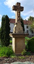
Piesbach, Trinity Cross from 1821
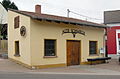
Old Forge

Interior of the forge
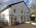
Piesbach, historic farmhouse from 1578
.jpg)
.JPG)
.JPG)
.jpg)
Events
.jpg)
Numerous events are organized in Piesbach over the course of the year (e.g. village festival, fair, cap meetings, Rose Monday parade, theater performances by the Volksbühne, beach volleyball tournament, Litermont rally). Club life in Piesbach is brisk. Clubs such as B. the gymnastics or sports club determine the sporting events in the village. At the end of 2006 the sports field in Piesbach was equipped with artificial turf.
Personalities
- Elisabeth Lehnert, (1882–19 ??), educator, author of numerous educational textbooks on German studies, sister of Aloys Lehnert .
- Albert André (1930–2014), monsignor , chaplain to His Holiness, former regional dean of the former Trier diocese region Saar-Hochwald, long-time pastor of the Piesbach parish of John the Baptist .
- Rosemarie Hoffmann, b. Schorn (1933-2004), writer
- Frank-Lorenz Engel (* 1961), actor and voice actor , grew up in Piesbach.
- Michael Müller-Kasztelan (* 1981), opera singer , tenor , grew up in Bettstadt and Piesbach.
- Adrian Becker (born May 14, 1970), grew up in Piesbach.
literature
- Georg Colesie: witch trials at the high court of Nalbach, in: Journal for the history of the Saar region, 17/18, 1969/1970.
- Georg Colesie: Vogteien und Vögte im Nalbacher Tal, in: Journal for the history of the Saar region, 20, 1972, p. 36.
- Georg Colesie: History of the Nalbach Valley, A Saarland Homeland History, 2nd edition, Nalbach 1990.
- Anton Edel: The inhabitants of the Nalbach valley 1800–1902 - Bettstadt, Bilsdorf, Diefflen, Körprich, Nalbach, Piesbach, ed. by Gernot Karge on behalf of the Association for Local Studies in the Saarlouis district, sources on genealogy in the Saarlouis district and neighboring areas, vol. 30, 2 volumes, Saarlouis 2004.
- Hans Peter Klauck: The inhabitants of the Nalbach valley before 1803, Bettstadt, Bilsdorf, Diefflen, Körprich, Nalbach, Piesbach, communications from the Arbeitsgemeinschaft für Saarländische Familienkunde eV, 26th special volume, ed. by Werner Habicht, Saarbrücken 1989.
Web links
Individual evidence
- ↑ www.nalbach.de - community data
- ↑ Georg Colesie: History of the Nalbacher Tales, Eine Saarländische Heimatgeschichte, 2nd edition, Nalbach 1990, pp. 122–125.
- ↑ George Colesie: history of Nalbacher Tales, a Saarland local history , 2nd ed Nalbach 1990. P. 14.
- ↑ State Main Archives Koblenz, Department 215, No. 1500.
- ↑ Hermann Maisant: The circle Saarlouis in prehistoric and early historical times, Saarlouis 1,971th
- ↑ George Colesie: history of Nalbacher Tales, a Saarland local history , 2nd ed Nalbach 1990. P. 19.
- ↑ Georg Colesie: Vogteien und Vögte im Nalbacher Tal, in: Journal for the history of the Saar region, 20, 1972, p. 36.
- ↑ George Colesie: history of Nalbacher Tales, a Saarland local history , 2nd ed Nalbach 1990. P. 23.
- ↑ George Colesie: history of Nalbacher Tales, a Saarland local history , 2nd ed Nalbach 1990. P. 23.
- ↑ Colesie, George: History of Nalbacher Tales, a Saarland local history, 2nd ed, Nalbach 1990, p 43, 83..
- ↑ Hans Peter Klauck: The inhabitants of the Nalbach valley before 1803, Bettstadt, Bilsdorf, Diefflen, Körprich, Nalbach, Piesbach, messages from the Arbeitsgemeinschaft für Saarländische Familienkunde eV, 26th special volume, ed. by Werner Habicht, Saarbrücken 1989, p. 16.
- ↑ Johnn Mathias Sittel: History and description of the quadrilateral rule of the Nalbacher Valley, manuscript in the State Main Archives Koblenz, Department 704, No. 486.
- ↑ Colesie, Georg: Geschichte des Nalbacher Tales, Eine Saarländische Heimatgeschichte, 2nd edition, Nalbach 1990, p. 32f.
- ↑ Trier City Archives, Certificate V, 24.
- ↑ State Main Archives Koblenz, Department 215, No. 561.
- ↑ Georg Colesie: History of the Nalbacher Tales, Eine Saarländische Heimatgeschichte, 2nd edition, Nalbach 1990, pp. 122–125.
- ↑ State Main Archives Koblenz, Department 215, No. 1453.
- ↑ http://www.saarbruecker-zeitung.de/saarland/saarlouis/Renovierung-Nalbach;art2807,4651453 , accessed on May 16, 2016.
- ↑ Kurt Hoppstädter: The witch persecutions in the Saarland area, magazine for the history of the Saar region, IX, 1959, p. 215, p. 257-267.
- ↑ LHA Koblenz, Dept. 215, No. 1491.
- ↑ Déclaration des droits, juridictions, rentes et revenues du val de Nalbach consistant en six villages, appartenant à Monsieur L´Electeur de Trèves e au Seigneur de Dilling par invidis (AD. Nancy, Titres feodaux 1524ff, E 135), copy in the parish archives Nalbach.
- ↑ State Main Archives Koblenz, Department 215, No. 1465.
- ↑ LHA Koblenz, Order 1c, No. 3928, fol. 30f.
- ↑ The list of court costs is printed at: Saarländische Geschichte, Ein Quellenlesebuch, ed. v. Eva Labouvie , Saarland Library Vol. 15, Blieskastel 2001, pp. 166–167.
- ↑ Georg Colesie: Geschichte des Nalbacher Tales, Eine Saarländische Heimatgeschichte, 2nd edition, Nalbach 1990, p. 98.
- ^ Aloys Lehnert: History of the city of Dillingen / Saar . Dillingen 1968, pp. 122-124.
- ↑ Kurt Hoppstädter: The witch persecutions in the Saarland region, magazine for the history of the Saar region, IX, 1959, p. 237.
- ↑ Georg Colesie: Geschichte des Nalbacher Tales, Eine Saarländische Heimatgeschichte, 2nd edition, Nalbach 1990, p. 101.
- ↑ George Colesie: History of Nalbacher Tales, a Saarland local history, 2nd edition, Nalbach 1990, pp 89-102.
- ↑ Kurt Hoppstädter: The castle in Dillingen, in: Geschichtliche Landeskunde des Saarlandes, From the hand ax to the winding tower, ed. v. Kurt Hoppstädter u. Hans-Walter Herrmann, Vol. 1 with the assistance of Erhard Dehnke, Saarbrücken 1960, pp. 148–151, here p. 150.
- ↑ Colesie, George: History of Nalbacher Tales, a Saarland local history, 2nd ed, Nalbach, 1990, p.83..
- ↑ State Main Archives Koblenz, Department 215, No. 1491.
- ↑ George Colesie: history of Nalbacher Tales, a Saarland local history , 2nd ed Nalbach 1990. Pp. 84-85.
- ↑ Hans Peter Klauck: The inhabitants of the Nalbach valley before 1803, Bettstadt, Bilsdorf, Diefflen, Körprich, Nalbach, Piesbach, messages from the Arbeitsgemeinschaft für Saarländische Familienkunde eV, 26th special volume, ed. by Werner Habicht, Saarbrücken 1989, p. 115.
- ↑ Georg Colesie: History of the Nalbacher Tales, Eine saarländische Heimatgeschichte , 2nd edition Nalbach 1990, pp. 83–86.
- ↑ Colesie, Georg: Geschichte des Nalbacher Tales, Eine Saarländische Heimatgeschichte, 2nd edition, Nalbach 1990, pp. 140–142.
- ↑ George Colesie: history of Nalbacher Tales, a Saarland local history , 2nd ed Nalbach 1990. P. 170.
- ^ Motte, Bernhard: Manuscript in the Saarlouis city library, after Colesie, Georg: Geschichte des Nalbacher Tales, Eine Saarländische Heimatgeschichte, 2nd edition, Nalbach 1990, p. 173 u. 187.
- ↑ Georg Colesie: History of the Nalbacher Tales, Eine Saarländische Heimatgeschichte, 2nd edition, Nalbach 1990, p. 212.
- ↑ Georg Colesie: Geschichte des Nalbacher Tales, Eine Saarländische Heimatgeschichte, 2nd edition, Nalbach 1990, p. 216.
- ↑ George Colesie: History of Nalbacher Tales, a Saarland local history, 2nd edition, Nalbach 1990, pp 228-229.
- ↑ George Colesie: history of Nalbacher Tales, a Saarland local history , 2nd ed Nalbach 1990. Pp. 251-252.
- ↑ George Colesie: history of Nalbacher Tales, a Saarland local history , 2nd ed Nalbach 1990. P. 217.
- ↑ Georg Colesie: Geschichte des Nalbacher Tales, Eine Saarländische Heimatgeschichte, 2nd edition, Nalbach 1990, p. 229.
- ^ Result of the referendum in the Saar area of January 13, 1935, publication by the General Secretariat of the League of Nations, Nalbach municipal archive.
- ↑ Georg Colesie: History of the Nalbacher Tales, Eine Saarländische Heimatgeschichte, 2nd edition, Nalbach 1990, p. 217.
- ↑ Armin Jost, Stefan Reuter: "Dillingen in the Second World War". History workshop Dillingen / Saar, Dillingen 2002, pp. 313-320.
- ↑ Georg Colesie: Geschichte des Nalbacher Tales, Eine Saarländische Heimatgeschichte, 2nd edition, Nalbach 1990, p. 244.
- ↑ George Colesie: history of Nalbacher Tales, a Saarland local history , 2nd ed Nalbach 1990. P. 217.
- ↑ Georg Colesie: History of the Nalbacher Tales, Eine Saarländische Heimatgeschichte, 2nd edition, Nalbach 1990, p. 217.
- ^ Gerhard Franz: The victory of the naysayers, 50 years after the vote on the Saar Statute , Blieskastel 2005, p. 181.
- ^ Federal Statistical Office (ed.): Historical municipality directory for the Federal Republic of Germany. Name, border and key number changes in municipalities, counties and administrative districts from May 27, 1970 to December 31, 1982 . W. Kohlhammer, Stuttgart / Mainz 1983, ISBN 3-17-003263-1 , p. 807 .
- ↑ http://www.igab-saar.de/
- ↑ Delf Slotta: The Saarland coal mining industry, pictures of people, mines and mining environments, stories from contemporary witnesses, recorded by Georg Fox, ed. from RAG Aktiengesellschaft, Herne and the Institute for Regional Studies in Saarland eV (Schiffweiler), Dillingen / Saar 2011, ISBN 978-3-00-035206-5
- ↑ Article "Earthquake in Saarland - Collapsed cavities in the mine", Taz article from February 25, 2008.
- ^ RAG coal mining mining in Saarland ends in 2012, article in the Süddeutsche Zeitung from May 17, 2010
- ↑ Article "Saarland - Strongest earthquake due to coal mining", Saturday, February 23, 2008, 8:34 pm, focus-online
- ^ RAG Deutsche Steinkohle AG. ( Memento of the original from February 7, 2015 in the Internet Archive ) Info: The archive link was inserted automatically and has not yet been checked. Please check the original and archive link according to the instructions and then remove this notice. (accessed on July 4, 2010)
- ↑ State Office for Geology and Mining Rhineland-Palatinate, Seismological Service Southwest, http://www.lgb-rlp.de/ereignisse.html , accessed on September 16, 2014.
- ↑ Archived copy ( Memento of the original from September 18, 2014 in the Internet Archive ) Info: The archive link was inserted automatically and has not yet been checked. Please check the original and archive link according to the instructions and then remove this notice. , accessed September 16, 2014.
- ↑ George Colesie: History of Nalbacher Tales, a Saarland local history, 2nd edition, Nalbach 1990, pp 46-52.
- ^ Johann Spurk: Parish Chronicle of St. Josef Diefflen 1900–1975, Saarlouis 1975, pp. 23–24 and 351.
- ↑ Georg Colesie: History of the Nalbacher Tales, Eine Saarländische Heimatgeschichte, 2nd edition, Nalbach 1990, p. 219.
- ↑ Georg Colesie: History of the Nalbacher Tales, Eine Saarländische Heimatgeschichte, 2nd edition, Nalbach 1990, p. 196, p. 227–228.
- ↑ Georg Colesie: History of the Nalbacher Tales, Eine Saarländische Heimatgeschichte, 2nd edition, Nalbach 1990, p. 219.
- ↑ State Main Archives Koblenz, Department 215, No. 1477.
- ↑ William Hawner: The development of the elementary schools in the district of Saarlouis, National History Yearbook of the district Saarlouis in 1966, ed. from the Working Group for Local Studies of the Saarlouis District, p. 327-S. 340, here 329.
- ^ Memorandum on the occasion of the inauguration of the new school building in Piesbach on January 10, 1954, ed. from the community of Piesbach.
- ↑ George Colesie: history of Nalbacher Tales, a Saarland local history , 2nd ed Nalbach 1990. P. 212.
- ↑ Oranna Dimmig: Inventory of art in public space, Saarland, Nalbach municipality, in: Art in public space, Saarland, Volume 3, Saarlouis district after 1945, essays and inventory, ed. by Jo Enzweiler, Saarbrücken 2009, p. 249.
- ^ Saarforschungsgemeinschaft (ed.): The art monuments of the Ottweiler and Saarlouis districts, edited by Walter Zimmermann , 2nd, unchanged edition, Saarbrücken 1976, p. 247.
- ↑ Margarethe Thinnes: Road crosses and wayside shrines in Saarland, Saarbrücken 1985, p. 120.
- ↑ d-nb.info/gnd/126598983
- ^ Anton Edel: The Inhabitants of the Nalbach Valley 1800-1902, Bettstadt, Bilsdorf, Diefflen, Körprich, Nalbach, Piesbach, Gernot Karge (editor), Association for local history in the Saarlouis district, 2004.
- ↑ http://saarautoren.sulb.uni-saarland.de/hoffmann/