Rheiderland
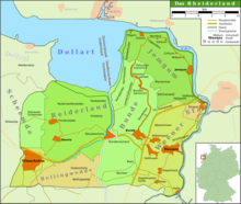
The Rheiderland is a stretch of land in Germany and the Netherlands between the Ems and Dollart . The German part of the Rheiderland is in East Frisia , west of the Ems. The Dutch part (written: Reiderland ) is in the Dutch province of Groningen and is often assigned to the Oldambt . On the mainland , the Rheiderland is one of the four historical landscapes of the district of Leer, alongside the Overledingerland , the Moormerland and the Lengenerland .
nature
The Rheiderland consists largely of marshland ( polder , Kooge ) and is just as flat as the rest of East Frisia, but there is even less tree planting here. This means the view extends to the horizon. The historic river march, which is up to 1.50 meters below sea level, runs along the Ems. Numerous meadow birds such as the lapwing , black godwit and redshank breed on the moist to wet meadows . In winter, up to 120,000 wild geese (especially white- fronted goose , barnacle goose and gray goose ) look for food here . The grassland area of the Rheiderland is also an intermediate resting place of "internationally outstanding importance" ( Federal Agency for Nature Conservation ) for golden plover , whimbrel , curlew and lapwing . This is why the area has been designated as a European bird sanctuary since 2000 . The bird sanctuary is called "V06 Rheiderland", has a size of 8,685 hectares and is rated as "one of the most important resting and wintering areas for Nordic geese in Lower Saxony".
- Compensation for feeding damage by host birds
On model areas, including grassland , the Lower Saxony Chamber of Agriculture examined the extent of the feeding damage caused by the host birds on behalf of the Lower Saxony Environment Ministry from 2015 to 2018, which has led to payments from the State of Lower Saxony to farmers since the 2010s. From the investigations, the chamber developed a model for the assessment and for differentiated financial payments to affected farmers. This will be tested in practice from spring 2019. The EU Commission has approved the cheap payments of the state of Lower Saxony for feeding damage from up to 15,000 euros per farm to 50,000 euros per year. Damages officially recorded since October 1, 2016 can also be included in this new regulation.
- Diked arable land
The north-western part of the Rheiderland was reclaimed by the Dollart through several dikes. The marshland is also very fertile, but due to the history of its origin, it is higher up and therefore suitable for arable land. The farmers used to be wealthy ( polder princes ), which is still reflected today in the magnificent Gulf farms. In the south of the Rheiderland there were also moor areas as foothills of the Bourtanger Moor . With the exception of a small residual moor near Wymeer , these are destroyed today.
history
The Rheiderland was settled by the Frisians early on . After the foreign rulers were expelled from Friesland in the 13th century , the Rheiderland, like the other Frisian areas, formed an independent imperial territory with a council constitution. Feudalism was unknown in these rural communities. The main places were probably Weener and Hatzum.

Initially, the Rheiderland was oriented more towards the Groninger Ommelande . It was only after the onset of the Dollart (from 1362), which flooded large areas of the Rheiderland and formed a natural border with the Ommelanden, that the state community turned more towards the Frisian areas east of the Ems. Up until the 20th century, many areas lost to the sea were reclaimed by invasion.
From 1413 the area fell under the rule of the chief family tom Brok and subsequently first to Focko Ukena and then to the Cirksena family . The state community was only able to become independent again for a short time. The now German part of the Rheiderland became part of the County of East Friesland and from then on shared its fate.
At the beginning of modern times, the Rheiderland was divided. The Oberrheiderland comprised the bailiwicks of Bingum, Weener and Bunde and belonged to the Leerort office. The Niederrheiderland comprised Jemgum and Ditzum and belonged to the office of Emden.
Formally, the Rheiderland was a separate country under the rule of the East Frisian counts until 1600, but was then finally annexed to East Frisia. In 1806 the Rheiderland was added to the department of Groningen ( Département Ems-Occidental ) in the Kingdom of Holland, later part of the Empire of France, and thus separated from East Frisia (the rest of East Frisia became the Département Ems-Oriental ). After the fall of Napoleon Bonaparte , what is now the German part of the Rheiderland was reunited with the rest of East Frisia through the resolutions of the Congress of Vienna in 1814. From then on it belonged to the Kingdom of Hanover , where it was assigned to the Landdrostei Aurich . The area of the Rheiderland was divided into the two offices of Jemgum and Weener, which were combined into one office of Weener in 1859.
In 1866, which was the Kingdom of Hanover by Prussia annexed and the province of Hannover redesigned. As part of the introduction of a new district order for the province, the Weener district was formed on April 1, 1885 from the Weener office . The Rheiderland thus formed an independent Prussian district. Due to its comparatively small size, the Weener district was dissolved by a regulation by the Prussian State Ministry in 1932 and merged with the Leer district.
After the Second World War, the Netherlands laid claim to the entire Rheiderland; however, these claims were rejected by the victorious powers. The Dutch had in fact been far replaced on the German side of the Rheiderland by the German as a high-level language. It was still understood and actively spoken by a large part of the population. The only legal and formal reason for the Dutch territorial claim, however, was that the Rheiderland was split off from East Frisia from 1806 to 1813 as part of the Kingdom of Holland and the Franco-Dutch departments. The victorious powers, however, had no interest in a territorial reorganization of Germany in the western border areas, and the Dutch annexation plans after the Second World War came to nothing.
religion
The Evangelical Reformed Church is predominant in the Rheiderland , to which around 70% of the population on the German side still belongs. The most important and widely visible ecclesiastical monuments of this denomination in the Rheiderland are the churches of Bunde , Ditzum and Jemgum . While the Bunde Church is the largest monument in the Rheiderland, the bell towers in Ditzum and Jemgum are built in a way that resembles lighthouses. In some places there are also Evangelical Lutheran parishes. Minorities are Old Reformed and Free Church communities , there is a single Catholic community in Weener. In this context, the region is also known for its large number of preserved church organs . The most important is the Arp Schnitger organ in the Evangelical Reformed Church in Weener .
On the Dutch side, the secession of the church has become much more prevalent. Only a minority belong to one of the Reformed churches. There are parishes of the Protestant Church in the Netherlands in Finsterwolde and Nieuweschans.
Culture and language
In the Rheiderland the Low German language is still widespread in everyday use. Most people in the German part of the Rheiderland speak East Frisian Platt (or a sub-dialect, the Rheiderländer Platt ) in their everyday life . In the Dutch part, in addition to the Dutch language, a dialect of the Groninger Platt is spoken, which is quite similar to the East Frisian Platt.
Up until the 19th century, Dutch was the dominant church language in the Rheiderland and left many traces in the local Low German dialect. The close cultural and linguistic connection with the Dutch side formed the pretext that the Netherlands claimed the area for themselves after the Second World War , but unsuccessfully ( see: History ).
politics
The largest place is the city of Weener . In administrative terms, the Rheiderland on the German side is divided into the communities Weener, Bunde and Jemgum as well as the district Bingum of the city of Leer and thus belongs entirely to the district of Leer . On the Dutch side, the municipality of Reiderland , the northern part of the municipality of Bellingwedde , the eastern part of the municipality of Scheemda and the municipality of Winschoten belong to the Rheiderland. In 2010 Reiderland, Scheemda and Winschoten were combined to form the new municipality of Oldambt , while Bellingwedde was incorporated into Westerwolde in 2018 .
Despite the almost non-existent industry and the low population density , the Rheiderland is a stronghold of social democracy .
coat of arms
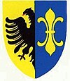
Blazon : "Split of gold and blue, in front a half red-tongued, black eagle at the crack, behind a golden double lily ."
The coat of arms goes back to a medieval seal. The eagle can be found in many Frisian coats of arms and stands for the imperial immediacy and thus the freedom of the Frisians. The lily is a pre-Reformation symbol of purity and stands for Mary, the patron saint of the Frisians. The coat of arms was carried by the former Weener district.
literature
- Dodo Wildvang : The Reiderland - a geological, common understanding. Self-published, Aurich 1920.
- David Steen, Georg-Siegfried Jantke (Hrsg.): The Rheiderland between Ems and Dollart. Risius, Weener 1987, ISBN 3-88761-035-0 .
- Helmut Kruckenberg, Matthias Bergmann: Cycling on the Dollard route. Isensee, Oldenburg 2000, ISBN 3-89598-700-X .
- Klaus Gerdes: The birds of the district of Leer. Schuster, Leer 2000, ISBN 3-7963-0348-X .
- Georg Klein: The Rheiderland. In: German Landscapes. S. Fischer, Frankfurt am Main 2003, ISBN 3-10-070404-5 .
- André R. Köller: Rheiderland or Reiderland? Risius, Weener 2006, ISBN 3-88761-099-7 .
- Frank Westerman : De graanrepubliek . Atlas, Amsterdam / Antwerp 1999, expanded 2009. [German edition: Das Getreideparadies. Ch. Links, Berlin 2009, ISBN 978-3-86153-550-8 .]
- Heimatverein Reiderland (ed.): The Rheiderland. New contributions to local history on the occasion of the 100th anniversary of the Reiderland Heimatverein. Risius, Weener 2019.
Web links
Coordinates: 53 ° 14 ' N , 7 ° 18' E
Individual evidence
- ↑ Description at the Federal Agency for Nature Conservation , accessed on March 24, 2019
- ↑ Description at NLWKN ( Lower Saxony State Office for Water Management, Coastal and Nature Conservation ), accessed on March 24, 2019
- ↑ Press release of the NLWKN from March 19, 2019, accessed on March 24, 2019
- ↑ Press release of the Lower Saxony Ministry of the Environment of April 3, 2019 ( online edition ), accessed on April 3, 2019
- ↑ David Steen, Paul Weßels : Ditzum, Gemeinde Jemgum, Landkreis Leer , accessed on April 24, 2015.
- ↑ Bernhard Uphoff: East Frisian mass and weights , Vol. 2: To the story . Verlag Ostfriesische Landschaft, Aurich 1973, p. 233.
- ↑ Statistical Handbook of the Kingdom of Hanover 1824
- ↑ Hannoversche Amtreordnung 1859
- ^ District regulation for the province of Hanover (1884)


