Extum
|
Extum
City of Aurich
|
|
|---|---|
| Coordinates: 53 ° 27 ′ 52 ″ N , 7 ° 27 ′ 0 ″ E | |
| Height : | 4 m |
| Area : | 4.17 km² |
| Residents : | 1728 (Jun 30, 2008) |
| Population density : | 414 inhabitants / km² |
| Incorporation : | July 1, 1972 |
| Postal code : | 26605 |
| Area code : | 04941 |
|
Location of Extum in Aurich
|
|
|
Place name sign Extum
|
|
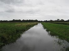
Extum is the westernmost district of the city of Aurich in East Frisia . It borders directly on the Aurich core town and in terms of area ranks third from last among the Aurich districts - only Popens and the neighboring district of Haxtum are even smaller. In terms of population, Extum is one of the medium-sized districts of Aurich. Extum includes the towns of Extumer Hammrich , Extumer Gaste and Extumer Kiefmoor to the west of the town center . The district is traversed by the Sandhorster Ehe, which flows into the ring canal, which finally leads to the Ems-Jade Canal . The natural flowing water contributes significantly to the drainage of the northern Aurich city area.
history
Extum is one of the oldest settlement areas in the Auricherland . It was one of the so-called "Negen Loogen" (high German: nine villages) that were located around the Aurich town center, which was later developed. In addition to Extum, these include Egels, Haxtum, Walle, Rahe, Sandhorst, Wallinghausen, Popens and Kirchdorf. The name goes back to the nickname Exte, connected with -heim, which over time became -um - as in many places in north-west Germany. The first written mention as Extum could not be found until 1431 - in a document listing the parishes of the Auricherland.
In the 1820s and 1830s, the extension settlements Extumer Hammrich, Extumer Gaste and Extumer Kiefmoor were settled. The first settler in Extumer Gaste (the East Frisian word for Eschflur ) was Jann Bohlen Oltmanns in 1822. In the same year, Arend Albers was the first settler to settle in Extumer Kiefmoor, the name of which is traced back to the fact that there was a dispute over the rights of use to that land: The Middle Low German kife (quarrel, dispute; cf. high German: quarrel) is the origin of the place name. Finally, in Extumer Hammrich, the first house was built in 1830.
In 1965, seven years before the Lower Saxony regional reform , the four then independent communities Extum, Haxtum, Rahe and Kirchdorf merged to form the Upstalsboom community. This lasted seven years, after which the named districts were incorporated into the city of Aurich on July 1, 1972.
politics
Extum has a seven-member local council together with the districts of Haxtum, Kirchdorf and Rahe .
Local mayor is Antje Harms (SPD).
Economy and Infrastructure
schools
The school center of the district town is located in the districts of Extum and Haxtum. The largest educational institution is the Integrated Comprehensive School Aurich, with 1,800 students the largest comprehensive school in East Friesland. In addition, the Aurich vocational schools are located in the school center, one of two BBS locations in the district next to the north . The school center is completed by two special schools with a focus on physical and motor development as well as learning.
traffic
The district is crossed in the north by the B 72 / B 210 , which in this area is the most heavily used section of a federal road in East Frisia with almost exactly 28,000 vehicles per day (as of 2007). To the south of the main road there is a larger industrial area, in which the then newly founded wind turbine manufacturer Enercon set up shop in 1984 . The company still has its headquarters on the Dreekamp street in that industrial area, which has since been greatly expanded, but production takes place in the north industrial area in the Sandhorst district. Otherwise, there are mainly (sometimes large) trading companies in the industrial park. In the still rural areas of Extumer Kiefmoor and Extumer Hammrich, agriculture is also practiced. For Extumer Kiefmoor, the district road Heuweg represents the connection to the main road and to the neighboring municipality of Ihlow.
The built-up area, in which the majority of the approximately 1,700 extumers live, is located south of that industrial area and therefore further away from the heavily used main road. The council of the city of Aurich has had more building areas designated in Extum in recent years, as the city-center and relatively easily accessible district was in high demand among many people willing to build.
Web links
- Ortschronisten der Ostfriesischen Landschaft : Extum, Stadt Aurich, Landkreis Aurich (PDF; 989 kB). Accessed July 19, 2013.
Individual evidence
- ^ Heinz Ramm: The beginnings of Aurich , in: Hajo van Lengen (ed.): Collectanea Frisica. Contributions to the historical regional studies of East Frisia. Walter Deeters on his 65th birthday. Ostfriesische Landschaft, Aurich 1995, ISBN 3-925365-86-9 , pp. 101–162, here: pp. 106ff.
- ^ Arend Remmers : From Aaltukerei to Zwischenmooren. The settlement names between Dollart and Jade , Verlag Schuster, Leer 2004, ISBN 3-7963-0359-5 , p. 67.
- ^ Arend Remmers: From Aaltukerei to Zwischenmooren. The settlement names between Dollart and Jade , Verlag Schuster, Leer 2004, ISBN 3-7963-0359-5 , p. 67.
- ^ Federal Statistical Office (ed.): Historical municipality directory for the Federal Republic of Germany. Name, border and key number changes in municipalities, counties and administrative districts from May 27, 1970 to December 31, 1982 . W. Kohlhammer, Stuttgart / Mainz 1983, ISBN 3-17-003263-1 , p. 261 .
- ^ Local council Extum / Haxtum / Kirchdorf / Rahe. Retrieved September 12, 2018 .
- ↑ Ostfriesischer Kurier, January 24, 2007, p. 9
- ↑ http://www.aurich.de/index.php?id=163&hid=28&xid=125 (link not available)


