Pfalzdorf (Aurich)
|
Pfalzdorf
City of Aurich
Coordinates: 53 ° 30 ′ 7 ″ N , 7 ° 34 ′ 33 ″ E
|
|
|---|---|
| Height : | 13 m |
| Area : | 6.11 km² |
| Residents : | 259 (Jun 30, 2008) |
| Population density : | 42 inhabitants / km² |
| Incorporation : | July 1, 1972 |
| Postal code : | 26607 |
| Area code : | 04947 |
|
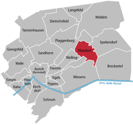
Location of Pfalzdorf in the Aurich city area
|
|
Pfalzdorf is a district of the city of Aurich in East Frisia .
geography
The place is in the east of the district town and borders (clockwise, starting in the north) on the neighboring districts of Plaggenburg, Spekendorf, Brockzetel, Wiesens, Egels and Wallinghausen. In the east of the district is the extensive, now cultivated Pfalzdorfer Moor, which is part of the East Frisian Central High Moor between the north of Aurich and the municipality of Uplengen . In the north of the district there are afforested areas. With 259 inhabitants, Pfalzdorf is the smallest of the 21 Aurich districts.
history
Pfalzdorf owes its name to settlers from the Palatinate who settled the place from 1802. It is one of three of the so-called Pfalzdörfer in the Aurich city area, the other two are Plaggenburg and Dietrichsfeld . The settlers came to East Frisia via an intermediate station from Pfalzdorf on the Lower Rhine. The place emerged as a bog colony .
During the time of National Socialism , the Pfalzdorfer Moor was one of seven camps of the Reich Labor Service in East Friesland, in which around 1,400 people were employed. They were used in peatland cultivation and in road construction. During the Second World War , a dummy airport was created near Pfalzdorf to divert Allied bombers from Wittmundhafen air base a few kilometers to the east . As a result, some bombs fell in the Pfalzdorf area, some of which had to be defused as duds decades later. Pfalzdorf has been part of the city of Aurich since July 1, 1972.
politics
Pfalzdorf has a five-member local council together with the districts of Dietrichsfeld and Plaggenburg .
The local mayor is Nikolaus Friedrichs (CDU).
Individual evidence
- ^ Arend Remmers : From Aaltukerei to Zwischenmooren. The settlement names between Dollart and Jade , Verlag Schuster, Leer 2004, ISBN 3-7963-0359-5 , p. 78.
- ↑ Manfred Staschen: The labor and prison camps around Aurich and the concentration camp satellite camp in Engerhafe, in: Herbert Reyer (Ed.): Aurich im Nationalozialismus (treatises and lectures on the history of East Frisia, volume 69), Verlag Ostfriesische Landschaft, Aurich 1993, ISBN 3-925365-49-4 , p. 423.
- ↑ Engbert Grote: Aurich im Luftkrieg, in: Herbert Reyer (Hrsg.): Aurich im Nationalsozialismus (treatises and lectures on the history of East Frisia, volume 69), Verlag Ostfriesische Landschaft, Aurich 1993, ISBN 3-925365-49-4 , p. 456.
- ^ Federal Statistical Office (ed.): Historical municipality directory for the Federal Republic of Germany. Name, border and key number changes in municipalities, counties and administrative districts from May 27, 1970 to December 31, 1982 . W. Kohlhammer GmbH, Stuttgart / Mainz 1983, ISBN 3-17-003263-1 , p. 261 .
- ↑ Local Council Dietrichsfeld / Pfalzdorf / Plaggenburg ( page no longer available , search in web archives ) Info: The link was automatically marked as defective. Please check the link according to the instructions and then remove this notice.
