
Wiesens
|
Wiesens
City of Aurich
|
|
|---|---|
 |
|
| Height : | 8 m |
| Area : | 16.73 km² |
| Residents : | 1419 (Jun. 30, 2008) |
| Population density : | 85 inhabitants / km² |
| Incorporation : | July 1, 1972 |
| Postal code : | 26605 |
| Primaries : | 04941, 04943 |
 Location of Wiesens in the Aurich city area
|
|
 John the Baptist Church
|
|
Wiesens is a district of Aurich in East Frisia .
history
Until the municipal area reform , which came into force on July 1, 1972, it was an independent municipality.
politics
Wiesens has a five-member local council. Gerhard Wulff (DIE LINKE) has been the local mayor since 2016.
Culture and sights
Historical center of the village is on a mound lying Lutheran Church with its baroque pulpit from 1735 and belonging to the church cemetery.
- The St. John the Baptist Church is a brick building from the 13th century with a free-standing bell tower. In the bell tower is the oldest still ringing bell in East Frisia, which dates back to the time the church was built. In the 15th century, the round apse that had existed until then was replaced by a rectangular choir and in 1818 four meters from the height of the church walls were removed. The organ was built by Johann Gottfried Rohlfs from 1820 to 1822 .
- North of the church by the "thirteen oaks" is the Tjedestein, on which a fork-like structure and a cross-shaped representation are heavily weathered.
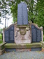
- The memorial for the fallen soldiers of the First World War in front of the church is the work of the Aurich sculpting company Flessner and Schulenburg (also: Fleßner and Schulenburg). It was erected in 1920.

Monument to the fallen in Wiesens (October 2015) - general view -
Monument to the fallen in Wiesens (October 2015) - Detail -
.JPG)
.JPG)
Economy and Infrastructure
The L 34 leads through the village. There is a primary school in Wiesens. Wiesens is located on the Ems-Jade Canal and has a contact point that is approached by the MS Aurich . The local sports club is SC "Dreizehn Eichen" Wiesens.
Web links
- Genealogy-Forum.de: The church in Wiesens
Individual evidence
- ^ Federal Statistical Office (ed.): Historical municipality directory for the Federal Republic of Germany. Name, border and key number changes in municipalities, counties and administrative districts from May 27, 1970 to December 31, 1982 . W. Kohlhammer GmbH, Stuttgart / Mainz 1983, ISBN 3-17-003263-1 , p. 261 .
- ^ Ostfriesische Nachrichten: Brockzetel / Wiesens: Linker als Local Mayor. Accessed on December 1, 2016
- ^ HA Lauer in: Archaeological monuments between Weser and Ems. Isensee Oldenburg 2000 p. 197/8
- ^ East Frisian Landscape : East Frisian Fallen Memorials . Retrieved October 5, 2015.
Core city | Brockzetel | Dietrichsfeld | Egels | Extum | Georgsfeld | Haxtum | Kirchdorf | Langefeld | Middels | Pfalzdorf | Plaggenburg | Popens | Rahe | Sandhorst | Shirum | Spekendorf | Tannenhausen | Walle | Wallinghausen | Wiesens