Langefeld (Aurich)
|
Langefeld
City of Aurich
|
|
|---|---|
| Coordinates: 53 ° 32 ′ 44 " N , 7 ° 33 ′ 45" E | |
| Height : | 10 m |
| Area : | 4.79 km² |
| Residents : | 457 (Jun 30, 2008) |
| Population density : | 95 inhabitants / km² |
| Incorporation : | July 1, 1972 |
| Postal code : | 26607 |
| Area code : | 04947 |
|
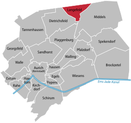
Location of Langefeld in the Aurich city area
|
|
Langefeld is a district in the northeast of the city of Aurich in East Frisia .
geography
The place borders in the east and southeast on the district of Middels, in the west and southwest on the district of Dietrichsfeld and in the north on the communities Blomberg in the joint community of Holtriem and Dunum in the joint community of Esens . The district is about ten kilometers from the Aurich core town. In terms of both area and inhabitants, it is one of the smallest districts of Aurich.
history
Langefeld was founded in 1780/81 by the Aurich rent master Julius Dietrich Tannen (1752–1829), who was also responsible for the creation of today's Tannenhausen district around 20 years later. Before the village was founded, the Langefeld district was known as Deepe Delle ( East Frisian Low German for deep hollow ), and the street name of the same name reminds of this name. The area was in a depression on the Geest , surrounded by moor . The moor was drained via the Langefelder Tief, which flows into the Benser Tief and flows into the North Sea at Bensersiel . In contrast to most of the Aurich urban area, Langefeld is not drained via the Ems .
The street village was laid out along the old postal route that led from Aurich to Esens. In the first 60 years or so of its history, the place grew very quickly: In 1821 there were 142 inhabitants, in 1848 it had 246. However, since the soil could not support the increasing number of colonists, many people emigrated from the middle of the 19th century. especially in the USA . The population growth almost came to a standstill, shortly before the outbreak of the Second World War , the town with 273 inhabitants had only a little more than 1848. After the war, the proportion of people displaced from the east in Langefeld - corresponding to the rather poor soil - was correspondingly low: in 1946 it was The rate was 5.8 percent and fell again to 5.3 percent by 1950.
With the increasing use of technology in agriculture, yields were improved, but jobs were also lost, so that the place became a commuter place early on , especially to the district town of Aurich. Since July 1, 1972, Langefeld has been one of 21 Aurich districts. Due to the designation of building sites, the number of residents has now risen to around 450.
politics
Langefeld has a five-member local council together with the districts of Middels and Spekendorf .
The local mayor is Arnold Gossel (CDU).
Individual evidence
- ^ Ortschronisten der Ostfriesische Landschaft: Langefeld (PDF; 634 kB), accessed on April 7, 2012.
- ^ Arend Remmers : From Aaltukerei to Zwischenmooren. The settlement names between Dollart and Jade , Verlag Schuster, Leer 2004, ISBN 3-7963-0359-5 , p. 138.
- ^ Ortschronisten der Ostfriesische Landschaft: Langefeld (PDF; 634 kB), accessed on April 7, 2012.
- ^ Federal Statistical Office (ed.): Historical municipality directory for the Federal Republic of Germany. Name, border and key number changes in municipalities, counties and administrative districts from May 27, 1970 to December 31, 1982 . W. Kohlhammer GmbH, Stuttgart and Mainz 1983, ISBN 3-17-003263-1 , p. 261 .
- ↑ Local council Langefeld / Middels / Spekendorf ( page no longer available , search in web archives ) Info: The link was automatically marked as defective. Please check the link according to the instructions and then remove this notice.

