Sandhorst
|
Sandhorst
City of Aurich
|
|
|---|---|
| Coordinates: 53 ° 29 ′ 24 ″ N , 7 ° 29 ′ 41 ″ E | |
| Height : | 8 m |
| Area : | 10.77 km² |
| Residents : | 4189 (Jun 30, 2008) |
| Population density : | 389 inhabitants / km² |
| Incorporation : | July 1, 1972 |
| Postcodes : | 26603, 26607 |
| Area code : | 04941 |
|
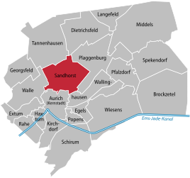
Location of Sandhorst in the Aurich city area
|
|
Sandhorst is a district of the district town of Aurich in the Aurich district in East Friesland , Lower Saxony .
geography
The district of Sandhorst is located north of the city center. Neighboring districts are Tannenhausen, Dietrichsfeld, Plaggenburg, Wallinghausen, Aurich and Walle.
history
The formerly independent community of Sandhorst has existed for several hundred years. It was incorporated into Aurich on July 1, 1972 as part of the Lower Saxony municipal reform. Today Sandhorst is with around 375 people per square kilometer the most densely populated of the 21 districts of Aurich after the core town of Aurich and the Popens district. Around 4,000 people live in an area of around 10.8 square kilometers.
politics
Sandhorst has a seven-member local council.
The local mayor is Eckhard Hattensaur (SPD).
Culture and sights
In terms of tourism, Sandhorst offers, among other things, a large wooded area with children's play facilities, a fitness trail and the Sandhorster Mill , built in 1908 . Extensive moorland areas can be found to the north and west of Sandhorst, but - especially in the east - they have been cultivated for decades.
Economy and Infrastructure
Sandhorst and the neighboring district of Tannenhausen in the north share a large industrial area. Among other things, there are production systems from the wind turbine manufacturer Enercon . For the delivery of the systems, the trucks have to cross the city to get to the port of Emden or to the A 31 and A 28 motorways . This led to significant traffic problems. For this reason, an existing siding was reactivated in 2008 in order to shift transport from road to rail.
Another important economic factor was the Blücher barracks, where the 4th division of the Air Force was based. The location was given up as part of the realignment of the Bundeswehr in 2013. In the 1960s, apartments were built in Sandhorst for the soldiers' families in their vicinity. There is also a church, schools and kindergartens nearby.
Personalities
- Ewald Christophers (1922–2003), German author, from 1959 teacher in Sandhorst
- Hansa Czypionka (* 1958), German actor, born in Sandhorst
- Wilhelm Dyckerhoff (1868–1956), district administrator, owner of the Sandhorst estate
- Walther Graetsch (* 1953), German politician (FDP), born in Sandhorst
- Udo Steffens (* 1950), economist and university lecturer, born in Sandhorst
- Enno Vocke (1925–2018), manager, born in Sandhorst
Web links
Individual evidence
- ^ Federal Statistical Office (ed.): Historical municipality directory for the Federal Republic of Germany. Name, border and key number changes in municipalities, counties and administrative districts from May 27, 1970 to December 31, 1982 . W. Kohlhammer GmbH, Stuttgart / Mainz 1983, ISBN 3-17-003263-1 , p. 261 .
- ↑ Ortrat Sandhorst ( page no longer available , search in web archives ) Info: The link was automatically marked as defective. Please check the link according to the instructions and then remove this notice.

