Hagermarsch
| coat of arms | Germany map | |
|---|---|---|

|
Coordinates: 53 ° 39 ′ N , 7 ° 18 ′ E |
|
| Basic data | ||
| State : | Lower Saxony | |
| County : | Aurich | |
| Joint municipality : | Hage | |
| Height : | 2 m above sea level NHN | |
| Area : | 22.32 km 2 | |
| Residents: | 431 (Dec. 31, 2019) | |
| Population density : | 19 inhabitants per km 2 | |
| Postal code : | 26524 | |
| Area code : | 04938 | |
| License plate : | AUR, NOR | |
| Community key : | 03 4 52 009 | |
| LOCODE : | DE HM2 | |
| Community structure: | 4 districts | |
| Association administration address: | Main street 56 26524 Hage |
|
| Website : | ||
| Mayor : | Richard Gloger (Free Association of Voters (FWG)) | |
| Location of the municipality of Hagermarsch in the Aurich district | ||
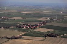
Hagermarsch is the smallest municipality in terms of population in the integrated municipality of Hage in the Aurich district in East Frisia . The community has 431 inhabitants, who are spread over four districts. It extends over an area of 22.32 square kilometers.
Surname
The first written mention of the community name can be traced back to 1719 in the spelling Hager Marsch . The current spelling is documented for 1787.
geology
The municipality of Hagermarsch is almost entirely located in the former Hilgenrieder Bay (also called Hagermarscher Bay ), the foothills of which, the Hilgenriede and the Wichter Ee , protruded deep into the Norderland until the 8th century and found their natural boundary in the Hager Geestrücken . The municipal area is characterized by the so-called Jungmarsch and has “fresh young soils with a still high lime content.” In terms of quality, they correspond to the best loess soils and are particularly suitable for arable farming .
Location and transport links
The northern border of the municipality of Hagermarsch, which is at an average height of 1.5 m above sea level (NN), forms the North Sea coast. In front of it is the eastern end of the island of Norderney . In the east, Hagermarsch borders on Nessmersiel , a district of the municipality of Dornum . The municipality shares the southern border with Hage and Lütetsburg , the western border with Ostermarsch , a district of the north of the city .
The Highway 5 connects Hagermarsch with the city north and the Sielorten Nessmer- and Dornumersiel . It is crossed by Kreisstraße 213 in the district of Theener . This leads in a northerly direction to Hilgenriedersiel and south on the district road 210, which connects Hage, the headquarters of the integrated community, with Nesse .
The Ems-Jade Transport Association (VEJ) offers a number of bus routes that connect Hagermarsch with the surrounding towns. For example, the VEJ bus line 414 leads to the north and Hage, the VEJ line 413 to Dornumersiel and the lines 314 and 319 to Dornum. The nearest train stations are in the north . In Hage there is a stop for a museum railway that runs between the north and Dornum during certain times of the year. There are boat connections to the islands in Norddeich ( Juist and Norderney) and Nessmersiel ( Baltrum ).
Community structure
The municipality consists of the districts Hagermarsch, Hilgenriedersiel , Theener and Junkersrott . While the three first-mentioned localities formed a municipality before the regional reform in Lower Saxony , Junkersrott was an independent municipality until the reform in 1972.
history
Most of the Hagermarsch community lies within the historic Hilgenried Bay. The earliest documented mention is dated to 1719. At that time the place is called as in the Hager Marsch . The place name is a combination of the settlement name Hage and the land form Marsch . The current spelling has been used since 1787.
The settlement of the place is likely to have started earlier. For example, there are some homestead sausages around the small, early medieval cemetery of Süderhaus , of which, however, no finds are known to date, so that it is difficult to date the beginning of the settlement.
In the area of the former Hilgenriederbucht in 884 a Frisian army under Archbishop Rimbert of Bremen-Hamburg and an army of Danish Vikings are said to have met in the Battle of Norditi (also Battle of Nordendi or Battle of Hilgenrieder Bay ) . The Frisians won, which resulted in the complete withdrawal of the Vikings from East Frisia .
In the district Hilgenriedersiel since 1576 a Siel proven. In 1925 it was closed due to a lack of receiving water. Today a monument commemorates the historic Siel. Hilgenriedersiel was important for the crossing and traffic with the North Sea island of Norderney until 1873. Then the island traffic shifted to the port of Norddeich . However, the Hilgenrieder Wattweg was still used by private forwarders until 1949.
In 1871 a brick factory in Hagermarsch is mentioned, in 1930 a Hagermarscher Landstrasse .
During the Second World War , the National Socialists set up a prisoner-of-war camp in the Hagermarsch. It consisted of a wooden barracks in which 25 to 30 French prisoners of war were imprisoned. Hagermarsch has been part of the Hage community since 1971.
religion
The vast majority of Hagermarsch's residents belong to the Evangelical Lutheran regional church of Hanover . They are parish in Hage ; the church responsible for them is the local St. Ansgari Church . The Roman Catholic Christians belong to the parish community of St. Ludgerus, based in the north. In Hage it has the St. Wiho branch church on Bahnhofsstraße. Free Churches (for example Baptists , Mennonites and Pentecostals ) can find their respective community centers in the nearby north .
politics
Municipal council
The Hagermarsch community council consists of 7 councilors. This is the specified number for the member municipality of an integrated municipality with a population of up to 500 inhabitants. The seven council members are elected by local elections for five years each. The current term of office began on November 1, 2016 and ends on October 31, 2021.
The last local election on September 11, 2016 resulted in the following:
| Political party | Proportional votes | Number of seats | Change voices | Change seats |
|---|---|---|---|---|
| SPD | 42.83% | 3 | - 3.83% | 0 |
| Free Association of Voters (FWG) | 46.65% | 3 | + 2.75% | 0 |
| CDU | 10.50% | 1 | + 8.52% | 0 |
The turnout in the 2016 local elections was 65.24%, well above the Lower Saxony average of 55.5%. For comparison, in the previous local election on September 10, 2006, the turnout was 64.77%.
mayor
The local council elected local council member Richard Gloger (Free Voting Association (FWG)) as honorary mayor for the current electoral term.
coat of arms
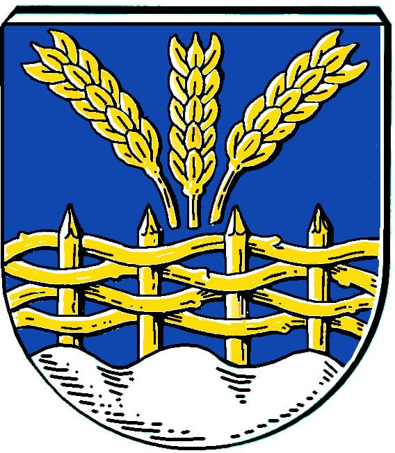
| Blazon : "A golden braided fence growing in blue under three fan-shaped golden ears from a silver corrugated shield base." | |
| Justification of the coat of arms: The golden ears of corn stand for agriculture on the fertile marshland. The wattle fence is reminiscent of the relationship between the Hager Marsch and the Flecken Hage ( Hage means enclosure , enclosed woodland ). The waves in the base of the shield symbolize the location of Hagermarsch behind the North Sea dike and the threat to the country from the sea. The colors blue and gold refer to the old district north to which the place originally belonged. |
literature
- Johann Haddinga , Martin Stromann: Hage health resort. With the villages of Blandorf-Wichte, Berum, Berumbur, Hagermarsch, Halbemond, Lütetsburg. Norden 2002, ISBN 3-928327-55-0 .
- Karl Leiner: Panorama North District. Norden 1972, pp. 167-170 (Hagermarsch), pp. 201-204.
Web links
- Health resort Hage
- Compensation work for coastal protection measures on the Leybucht with extensive dyke reinforcement and new construction measures
- Old photos from Hagermarsch, Hilgenriedersiel, Dornum, Dornumergrode and Dornumersiel
Individual evidence
- ↑ State Office for Statistics Lower Saxony, LSN-Online regional database, Table 12411: Update of the population, as of December 31, 2019 ( help ).
- ↑ a b local chronicles of the East Frisian landscape : Hagermarsch, Samtgemeinde Hage, district Aurich
- ↑ Hans-Gerd Coldewey: Bicycle tour on the traces of earlier dyke lines, sluices and harbors in Hage. (online on the homepage of the SPD Hage); accessed on March 1, 2015.
- ^ Karl-Ernst Behre: East Frisia. The history of its landscape and its settlement. Wilhelmshaven 2014, ISBN 978-3-941929-09-8 , p. 34.
- ^ East Frisian landscape: Hagermarsch, Samtgemeinde Hage, Aurich district
- ↑ Verkehrsverbund Ems-Jade: Line network , accessed on April 29, 2019.
- ↑ Internet presence of the Ostfriesland coastal railway ; accessed on February 23, 2015.
- ↑ See also Karl Leiner: Panorama district north. Norden 1972, p. 169f.
- ^ Federal Statistical Office (ed.): Historical municipality directory for the Federal Republic of Germany. Name, border and key number changes in municipalities, counties and administrative districts from May 27, 1970 to December 31, 1982 . W. Kohlhammer, Stuttgart / Mainz 1983, ISBN 3-17-003263-1 , p. 264 .
- ^ Arend Remmers : From Aaltukerei to Zwischenmooren. The settlement names between Dollart and Jade , Leer 2004, p. 90
- ^ Karl-Ernst Behre : East Frisia. History and shape of a cultural landscape . Ed .: Hajo van Lengen . Ostfriesische Landschaftliche Verlags- und Vertriebsgesellschaft, Aurich 1995, ISBN 3-925365-85-0 . P. 80
- ^ Arend Remmers : From Aaltukerei to Zwischenmooren. The settlement names between Dollart and Jade , Leer 2004, p. 90
- ^ Karl Leiner: Panorama district north. Norden 1972, p. 169; 203
- ↑ Homepage of the parish community St. Ludgerus: St. Wiho Hage ; accessed on March 1, 2015.
- ^ Lower Saxony Municipal Constitutional Law (NKomVG) in the version of December 17, 2010; Section 46 - Number of MPs , accessed on December 31, 2016.
- ↑ a b Hagermarsch municipality - overall results of the 2016 municipal council election , accessed on December 31, 2016.
- ↑ hna.de: Local elections: All information, all results , accessed on December 31, 2016.
- ^ Hagermarsch community - overall results of the 2011 local council election , accessed on December 31, 2016.
- ↑ Samtgemeinde Hage - Gemeindeorgane , accessed on January 22, 2017
- ^ Karl Leiner: Panorama district north. Norden 1972, p. 167.


