
Easter March (North)
|
Easter March
City north
|
|
|---|---|
 |
|
| Height : | 2 m above sea level NN |
| Area : | 13.14 km² |
| Residents : | 274 (December 31, 2016) |
| Population density : | 21 inhabitants / km² |
| Incorporation : | July 1, 1972 |
| Postal code : | 26506 |
| Area code : | 04938 |
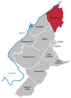  Location of Easter March in the urban area from the north
|
|
Easter March is the name of a municipality that was independent until the local reform in 1972. Today, Ostermarsch is a district in the northeast of the East Frisian city of Norden and has around 300 inhabitants (12/2016) spread over an area of 13.14 km².
Surname
The first part of the name of the place ( Oster from the direction east ) is derived from its location in the Norderland , in which there are also the localities Westermarsch I and Westermarsch II .
Location description
.jpeg&filetimestamp=20160807084737&)

Easter March covers an area of 1313.5 hectares . In the north of the place the Wadden Sea forms the natural boundary. Junkersrott is in the east . The southern extension extends to the old northern city limits, while in the west the watercourse of the Sieltog separates the Ostermarsch area from Lintelermarsch .
While the southern part of Easter March offers a distinctive meadow and pasture landscape, the northern part of the village is characterized by agriculture .
In the town center there is a former school building, which was run as a one-room elementary school until 1963. There are also smaller handicraft businesses and a windmill hull. The country road 5 cuts through the whole place in an east-west direction. Otherwise, Easter March consists of scattered large farming Gulf yards and small settlements with three to five buildings each.
history

Easter March is a place characterized by dike construction and the associated land reclamation . In addition to the ancient mounds Sieltog and Süderhus whose beginnings before 1000, can be south of the provincial road 5 represent an old dike line, both threw bound them together. The state road itself is the dike foot of a dike built around 1200 in the Ostermarscher area. In the first half of the 15th century, the construction of the so-called Olldiek ( old dike ) protected new land from the sea. This dike runs north of the state road. There are three old Gulf yards on this line of the dike. Today's dike line goes back to the construction of the New Dike , which took place in 1576 and closed the 10 km wide gap between Lintelermarsch and Hilgenriede . On the border between the Lintelermarscher and Ostermarscher dykes, a reminder of this dyke construction and at the same time as a border marker is the red post .
Several large storm surges broke this dyke line in the course of history, including the Christmas flood of 1717 and the February flood of 1825. During the great storm surge of 1962, the front dike of the Almond Polder (built in 1679) was breached. However, the flooded land could be reclaimed and is now used for agriculture.
On July 1, 1972, the municipality of Ostermarsch was incorporated into the city of Norden.
Attractions
Special architectural monuments such as castles and churches are missing in Easter March. What is interesting, however, is the original and therefore typical marshland with its warps and drainage systems. The knowledgeable observer can also see the old dyke construction lines, which bear witness to the tremendous workload of previous generations.
religion
Over 90% of the population on Easter March belong to the Evangelical Lutheran Church . As a congregation, it has always been part of the parish of the Ludgeri Church in the north. A service is offered in the old school on the 1st Sunday of each month.
Transport links
Landesstraße 5 connects Ostermarsch with the north and north dike (mole) in the west and with the sewage locations Neßmersiel and Dornumersiel in the east.
Rail travelers change to the Weser-Ems transport company bus to Dornumersiel at the north central station.
In Lintelermarsch there is also a small airfield with flights to Juist and Norderney .
literature
- Karl Leiner: Panorama Landkreis Norden , Norden 1972, pp. 343-350
Web links
Individual evidence
- ↑ Norden.de: Population according to districts
- ↑ Norden.de: districts of the city north
- ^ Norder schools - Powerpoint presentation for the 750th anniversary of the city of Norden ; Accessed April 3, 2010
- ^ Federal Statistical Office (ed.): Historical municipality directory for the Federal Republic of Germany. Name, border and key number changes in municipalities, counties and administrative districts from May 27, 1970 to December 31, 1982 . W. Kohlhammer GmbH, Stuttgart and Mainz 1983, ISBN 3-17-003263-1 , p. 264 .
- ^ Homepage of the Evangelical Lutheran Ludgeri Church Congregation North: Other sermon locations ; accessed on February 22, 2015
_COA.svg)
.jpeg&filetimestamp=20160807084737)
Old districts: Armenplatz (today: Norden-Neustadt ) | Bargebur | Disgust | Hollande | Lintel | Westerners | West Lintel | Zingel
New districts in the north after the municipal reform:
Leybuchtpolder |
Lintelermarsch (today: part of Norddeich) |
Neuwesteel |
North dike |
Easter March |
Süderneuland I |
Süderneuland II |
Tido field |
Western March I |
Western March II