
Lintelermarsch
|
Lintelermarsch
City north
|
|
|---|---|
 |
|
| Height : | 2 m above sea level NN |
| Incorporation : | July 1, 1972 |
| Postal code : | 26506 |
| Area code : | 04931 |
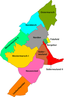  Location of Norddeich / Linterlermarsch (light blue) in the urban area from the north
|
|
Lintelermarsch has belonged to the city of Norden since 1972 . Better known as Lintelermarsch is Norddeich , the name of a former Lintelermarsch district, which developed into a district with its own communal character in the course of the flourishing island shipping and tourism. Today Norddeich is an independent district of the city of Norden and the Lintelermarsch is only a part of this district.
Location description

Lintelermarsch has no town center and mainly consists of scattered Gulf farms and small settlements of three to five houses. Among the numerous terps, the two large terps Osterloog and Westerloog stand out.
To the north of the Warf Osterloog is the former transmission point for the maritime radio service (see Norddeich Radio ). The transmission masts are dismantled today. In their place there is a small nature reserve. The former broadcasting building houses the so-called Waloseum , a permanent exhibition dedicated to the whale .
North of the Wharf Westerloog, the Norddeich airfield was created in 1968, which is mainly used for flights to and from the tide-dependent island of Juist . Flights to Norderney are also offered .
The Rote Pfahl is located directly on the Lintelermarscher dike , a public but unsupervised swimming area.
history
On July 1, 1972, the community Lintelermarsch was incorporated into the city of Norden.
coat of arms
Blazon : In the green head of the shield a silver fish with gold fins, underneath it in silver a red lightning bolt. The coat of arms of the former municipality of Lintelermarsch, which has formed the district of Norddeich since the municipal reform in 1972, was awarded to it on July 26, 1960. It reflects the history of the place. The lightning bolt stands for the former Osterloog transmitter, the red-silver color scheme was adopted from the paint on the transmitter towers. The green in the coat of arms stands for agriculture, the silver fish with gold fins for fishing.
Transport links
Lintelermarsch is located on Landesstraße 5 between the city of Norden and its Ostermarsch district . This country road is part of the Green Coast Road . Rail travelers use the Ems-Jade transport association buses from Norddeich station in the direction of Neßmersiel (line 303).
The Norden-Norddeich airfield is located within the Lintelermarsch district . It is approved for motor gliders and microlight aircraft up to 2000 kg and helicopters up to 5700 kg. The operator is FLN Frisia-Luftverkehr GmbH Norddeich, which is responsible for national scheduled air traffic from the Lower Saxony mainland to the East Frisian Islands all year round. The following island airports, among others, are served from the airfield in Lintelermarsch:
- Juist Airport Flight time approx. 5 minutes (airline with fixed flight times; additional flights required daily by arrangement)
- Norderney Airport Flight time approx. 5 min
- Airfield Baltrum Flight time approx. 8 min
- Langeoog Airport Flight time approx. 10 min
- Wangerooge airfield
- Borkum Airfield
In addition, sightseeing flights (of various duration) and day trips to Helgoland are offered.
Attractions

- Typical old marshland
- Terps Wester- and Osterloog
- Waloseum whale museum
- Car museum
- Norddeich airfield
literature
- Karl Leiner: Panorama district of the north - pictures, coats of arms, people, notes , north 1972
Individual evidence
- ^ Federal Statistical Office (ed.): Historical municipality directory for the Federal Republic of Germany. Name, border and key number changes in municipalities, counties and administrative districts from May 27, 1970 to December 31, 1982 . W. Kohlhammer GmbH, Stuttgart and Mainz 1983, ISBN 3-17-003263-1 , p. 264 .
- ↑ norden.de: district north dike , seen on April 22 of 2010.
_COA.svg)
Old districts: Armenplatz (today: Norden-Neustadt ) | Bargebur | Disgust | Hollande | Lintel | Westerners | West Lintel | Zingel
New districts in the north after the municipal reform:
Leybuchtpolder |
Lintelermarsch (today: part of Norddeich) |
Neuwesteel |
North dike |
Easter March |
Süderneuland I |
Süderneuland II |
Tido field |
Western March I |
Western March II