
Leybuchtpolder
|
Leybuchtpolder
City north
|
|
|---|---|
 |
|
| Height : | 2 m |
| Area : | 10.52 km² |
| Residents : | 463 (December 31, 2016) |
| Population density : | 44 inhabitants / km² |
| Incorporation : | July 1, 1972 |
| Postal code : | 26506 |
| Area code : | 04926 |
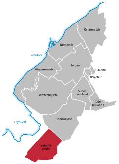  Location of Leybuchtpolder in the urban area from the north
|
|

Leybuchtpolder is a district of the north in East Friesland and was until 1972 an independent municipality. Geologically, Leybuchtpolder is the youngest of the northern districts and has 463 inhabitants (12/2016), who are spread over an area of 10.52 km². In the years 1947 to 1950, the polder was finally reclaimed from the North Sea when the almost 5 km long Störtebeker dike was closed. At the place where the dike was closed there is now a monument. From an administrative point of view, Leybuchtpolder is the second youngest district after Tidofeld , which only became an independent district in 1996.
history
When the Leybucht collapsed during a storm surge on October 9, 1374, around 20,000 hectares of land were flooded. Both the north (today's core city) and Marienhafe were given access to the open sea. The north remained a port city of some importance for centuries. In the following centuries, land reclamation measures were carried out successively , culminating in the dike in the Leybuchtpolder. More extensive dikes were considered in the 1950s, but later no longer implemented for nature conservation reasons, as the Leybucht is a bird resting area of international importance.
After the dike was completed, the settlement of the newly reclaimed land began in 1952. Both locals and displaced persons from the former eastern territories of the German Reich, who were taken in in the region in large numbers, were taken into account. Locals and displaced people each received half of the land. The dike workers who had made the land acquisition possible with their work were given preference.
The following settlement areas were created within the polder: 53 agricultural holdings with a size of ten to 16 hectares, 21 holdings with a size of seven to ten hectares, and 28 workers' and craftsmen's jobs with sites covering one hectare. About twelve kilometers of roads were laid.
The municipality of Leybuchtpolder was officially founded on July 1, 1954. From 1965 it was a member of the Leybucht Samtgemeinde , which was incorporated into the north as part of the Lower Saxony municipal reform on July 1, 1972 . Since then, Leybuchtpolder has been a district with its own mayor.
Infrastructure
The center of the place is the artificially created village pond. There is a primary school in Leybuchtpolder. In 2008 it was equipped with a sports hall, which was built largely through donations and with the own contributions of the residents. There is an Evangelical Lutheran and an Evangelical Reformed Church in the village. The sports offer is ensured by SV Leybucht , which has a sports field.
Individual evidence
- ↑ Norden.de: Population according to districts
- ↑ Norden.de: districts of the city north
- ↑ Norden.de: Leybuchtpolder
- ^ Eberhard Rack: Kleine Landeskunde Ostfriesland, Isensee Verlag, Oldenburg 1998, p. 92/93
- ^ Federal Statistical Office (ed.): Historical municipality directory for the Federal Republic of Germany. Name, border and key number changes in municipalities, counties and administrative districts from May 27, 1970 to December 31, 1982 . W. Kohlhammer GmbH, Stuttgart and Mainz 1983, ISBN 3-17-003263-1 , p. 264 .
_COA.svg)
Old districts: Armenplatz (today: Norden-Neustadt ) | Bargebur | Disgust | Hollande | Lintel | Westerners | West Lintel | Zingel
New districts in the north after the municipal reform:
Leybuchtpolder |
Lintelermarsch (today: part of Norddeich) |
Neuwesteel |
North dike |
Easter March |
Süderneuland I |
Süderneuland II |
Tido field |
Western March I |
Western March II