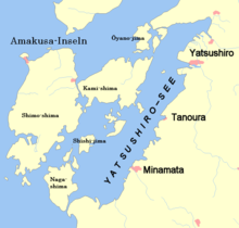
Amakusa Islands
The Amakusa Islands ( Japanese 天 草 諸島 , -shotō ) are a group of islands belonging to Japan .
They are located west of Kumamoto Prefecture and between Ariake Lakes and Yatsushiro Lakes . The largest islands are:
- Kami-shima ( 上 島 , German "upper island", 32 ° 27 ′ N , 130 ° 20 ′ E ),
- Shimo-shima ( 下 島 , German "lower island", 32 ° 22 ′ N , 130 ° 7 ′ E ),
- Naga-shima ( 長島 , German "long island", 32 ° 10 ′ N , 130 ° 9 ′ E ),
- Ōyano-jima ( 大矢野島 , dt. "Large arrow box island" 32 ° 35 ' N , 130 ° 26' O ) and
- Shishi-jima ( 獅子島 , dt. "Löweninsel", 32 ° 17 ' N , 130 ° 14' O ).
The islands do not have high mountains, but are very hilly, with four peaks rising over 500 m. Locals operate terraced fields on the hills with remarkable success.
A number of the executed leaders of the Shimabara rebellion in the first half of the 17th century were buried on this island.
The largest kaolin deposits in Japan are in Amakusa, and the proportion of the production volume is 80% of total Japanese production. The Amakusa kaolin is used by many well-known porcelain manufacturers in Japan and historically by the potters of Satsuma ( Satsuma porcelain ) and Hirado .
On the islands that belong to Kumamoto Prefecture, there are the cities of Amakusa and Kami-Amakusa , as well as the district of Amakusa with its only municipality, Reihoku . On the part belonging to the prefecture of Kagoshima there is the district of Izumi with its only municipality Nagashima .
Amakusa Airport is located on Shimo-shima Island .
Individual evidence
- ^ Encyclopædia Britannica . 10th edition. Volume XXV. Adam & Charles Black, Edinburgh & London 1902, p. 344 ( limited preview in Google Book search).
Coordinates: 32 ° 20 ' N , 130 ° 11' E
