
South Brookmerland
| coat of arms | Germany map | |
|---|---|---|

|
Coordinates: 53 ° 28 ' N , 7 ° 20' E |
|
| Basic data | ||
| State : | Lower Saxony | |
| County : | Aurich | |
| Height : | −1 m above sea level NHN | |
| Area : | 96.82 km 2 | |
| Residents: | 18,319 (Dec 31, 2019) | |
| Population density : | 189 inhabitants per km 2 | |
| Postal code : | 26624 | |
| Primaries : | 04942, 04941 , 04934 | |
| License plate : | AUR, NOR | |
| Community key : | 03 4 52 023 | |
| LOCODE : | DE SBD | |
| Community structure: | 10 districts | |
| Address of the municipal administration: |
Westvictorburer Strasse 2 26624 Südbrookmerland |
|
| Website : | ||
| Mayor : | Friedrich Süßen ( SPD ) | |
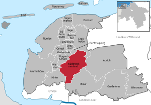
| Location of the community Südbrookmerland in the district of Aurich | ||
  |
||


The community Südbrookmerland is located in East Frisia in northwest Lower Saxony between the cities of Aurich and Emden . It was created on July 1, 1972 as part of the municipal reform through the amalgamation of ten previously independent municipalities, which today form the localities. With 18,319 inhabitants, Südbrookmerland is the third largest municipality in the Aurich district (after the cities of Aurich and Norden ) and the third largest rural municipality in East Frisia after Moormerland and Westoverledingen . It is characterized by agriculture and tourism with a focus on the Great Sea , the fourth largest inland lake in Lower Saxony. Overall, however, Südbrookmerland is a community of out-commuters , especially to Aurich and Emden, there especially to the Volkswagen plant in Emden .
The area of the municipality lies on part of the historical Brokmerland region , which was settled in the course of the medieval inland colonization. This is where the origins of the first planned moor colonization in East Frisia can be found. After the reclamation of parts of the raised bog areas, an economic boom followed, which allowed the construction of some exceptionally large churches. On the other hand, the establishment of some peatland colonies by Frederick the Great after the reclamation edict is viewed as an economic failure . The settlement of Moordorf in particular was considered a failure due to insufficient planning; for almost two centuries, the place was synonymous with poverty in East Frisian bog colonies. In 1944 there was a brief concentration camp in the district of Engerhafe .
The two different successful phases of bog colonization can be found in the cultural heritage of the community: In addition to the churches in Victorbur, Wiegboldsbur and in particular Engerhafe, the moor museum in Moordorf, in which the settlement conditions of the first moor settlers are described, is one of the cultural sights.
geography
Position and extent
Südbrookmerland is located in the north-west of Germany in East Frisia , roughly in the center of the Aurich district and the triangle of cities Aurich, Emden and Norden. Südbrookmerland borders directly on the cities of Aurich and Emden. The area of the municipality is located in a lowland zone on the western edge of the Oldenburg-East Frisian Geestrücke. This stretches from the Ley ( Norder Tief ) to the Flumm ( Fehntjer Tief ) and is interspersed with a series of shallow inland lakes, from the Great Sea to the Sandwater .
The community covers 96.8 square kilometers, which puts it in 15th place among the East Frisian municipalities in terms of size . Within the Aurich district, Südbrookmerland is the sixth largest municipality after Aurich, Krummhörn , Großefehn , Ihlow and Norden . With 19,010 inhabitants, the population density is 196 inhabitants per km². The community is thus far above the East Frisian (148 inhabitants per km²) and the Lower Saxony (168 per km²) average, but below the Federal Republican average of 230 per km². The largest extension in approximately north-south direction is around 15 kilometers between Moorhusen and the Ems-Jade Canal in the south, the largest east-west extension between Moordorf and the Engerhafer Meede in the west is around 11.5 kilometers.
The administrative seat of West-Victorbur is located about nine kilometers west of Aurich and about 18 kilometers northeast of Emden. Nearby major cities are Oldenburg and Bremen as well as Groningen in the Netherlands . In the regional planning of the state of Lower Saxony, Südbrookmerland is managed as the basic center . This means that the municipality has to provide central facilities and offers for general, daily basic needs.
Geology and hydrology

The municipal area lies in the transition area between marshland , geest and moor and thus has a share in all three landscape forms of the East Frisian mainland. On the surface, the municipal area is determined by layers of the Pleistocene (Geest) and Holocene (moor and marshland).
The oldest settlement centers are located on the Geest ridge that runs through the municipality. It is an extension of the Oldenburg-East Frisian Geestrücken, which runs in a south-east-north-west direction roughly from Oldenburg to the north . Sands and drifting sands from the Glacial Vistula form the subsoil of the oldest layers, such as Wiegboldsbur and Uthwerdum. Streams and other rivulets flowed abeam from this ridge, which also left sand and gravel river deposits of sand and gravel on the lower terrace , which also go back to the Vistula glaciation. This applies to the north and parts of the southern municipal area.
The formerly extensive moorland areas in the north of the Südbrookmerland were for the most part reclaimed by moor fire and (partly) peat removal. Today they have disappeared except for small remaining areas. Around the Great Sea in the extreme south of the municipality there is a sloping fen.
The marshland belonging to the so-called Sietlanden in the west of the municipality form the transition from the younger to the older East Frisian marshland. The younger march at Engerhafe and Abelitz consists of fine sands, silt and clay (tidal flats), to which the older marshland with brackish water deposits connect to the east.
The municipality is located at a height between 0.2 m below and 3 m above sea level. The area needs to be drained so that it is not flooded with persistent rain. Up until the 1970s, the moorland marshland were regularly flooded. Today the water is drained through countless small ditches as well as smaller and larger natural and artificial canals (regionally called deep ) and narrow and wider drainage ditches (regionally called schloot ). These are drained via the pumping station on the Knock, which was opened in 1969. The necessary receiving waters were also built by 1977 . Since then, the water levels in Südbrookmerland have been constant. The I. Drainage Association Emden , based in Pewsum, is responsible for drainage .

In the area of the municipality of Südbrookmerland there are two inland lakes and a number of natural and artificially created rivers. The Great Sea is the fourth largest lake in Lower Saxony. In the immediate vicinity is the Loppersumer Meer to the west , which is named after the nearby village of Loppersum in the neighboring community of Hinte , but is located entirely in the Südbrookmerlander area. Between 2009 and 2012 four weirs will be built on the Great Sea, with the help of which the Emden Drainage Association and the Lower Saxony State Agency for Water Management, Coastal and Nature Conservation (NLWKN) want to improve the water quality. On the other hand, the Great Sea is to serve as an additional retention basin after heavy rainfall through damming .
The southernmost border of the municipality is formed by the Ems-Jade Canal over a length of about three kilometers . The other bank of the canal belongs to the parish of Ihlow . The ring canal , which flows from Moorhusen in the north of the municipality via Moordorf to the municipality boundary near the village of Westerende in the neighboring municipality of Ihlow, was also artificially created . At Westerende it flows into the Ems-Jade Canal and serves to drain the low-lying area. The Abelitz-Moordorf Canal, which flows south-west near East Victorbur in the geographic center of the municipality, performs the same function. It drains to the Ems via the Abelitz River, the Neue Greetsieler Sieltief and the Knockster Tief .
The Knockster Tief begins on the northwest bank of the Great Sea, flows through the Loppersumer Sea and then flows on towards the Ems. This connection connects the northern part of the Great Sea and the Loppersumer Sea with the East Frisian waterway network. This fact plays an important role in boat tourism.
Territory and land use
| use | Area in ha |
|---|---|
| Buildings and open spaces | 1.166 |
| including living space | 838 |
| including commercial and industrial areas | 70 |
| Operating areas | 25th |
| Recreational areas | 71 |
| including green spaces | 46 |
| Traffic areas | 434 |
| of which streets, paths, squares | 408 |
| Agricultural land | 7,071 |
| of which moors | 18th |
| Bodies of water | 774 |
| Forest areas | 80 |
| Areas of other use | 60 |
| including cemeteries | 5 |
| of it land | 28 |
| total area | 9,682 |
The land use table on the right shows the overwhelming proportion of agricultural land in the municipality of Südbrookmerland of 73 percent. This means that Südbrookmerland is just below the East Frisian average of around 75 percent, but far above the national average of 52.3 percent.
In addition, bodies of water make up a considerable proportion of the area. Mention should be made of the Loppersumer and the Great Sea as well as countless smaller and larger drainage ditches and several canals that run through the municipal area. The canals are primarily used to drain the former moorland and the low-lying lands in the municipality. In earlier times they were also used with smaller vehicles for shipping. With 8 percent water area share, the national average of 2.4 percent is exceeded many times over.
On the other hand, only small remaining areas of the once extensive moors have survived, which together cover 0.2 percent of the municipal area. The proportion of forests is 0.82 percent and thus still below the East Frisian average of 2.6 percent, which in turn is considerably below the proportion of forests in the total area of the Federal Republic of Germany of around 29.5 percent. Except for wall hedge landscapes, there are only a few smaller afforested areas. Trees were also planted as vestibules, to enclose fields and as street green. In earlier centuries, the trees on the Geest areas were cleared in order to obtain timber and agricultural land.
Neighboring communities
The municipality is centrally located within the Aurich district and is the municipality belonging to the district with most of the neighboring communities (7) within the district. Südbrookmerland borders in the southwest on the municipality of Hinte , in the west and northwest on the municipalities of Werdenum , Upgant-Schott and Rechtsupweg (all three belong to the joint municipality of Brookmerland ), in the north on the municipality of Großheide , in the east on the city of Aurich and in the east and south to the community of Ihlow . All of these municipalities belong to the Aurich district . In the south, the community borders on a small section of the independent city of Emden .
There are close relationships with the neighboring cities of Emden and Aurich. The two largest cities in East Frisia are of great importance for the community of Südbrookmerland as shopping locations, but above all as places of work. This particularly applies to the Volkswagen factory in Emden , where many people from Südbrookmerland work.
Community structure

Südbrookmerland consists of ten former rural communities, which emerged immediately after the takeover of East Frisia by the Kingdom of Hanover (Oldeborg was formed in 1938 from the previously independent rural communities Engerhafe , Fehnhusen , Oldeborg and Upende ) and which were independent municipalities until the local government reform in 1972. The former communities emerged from the amalgamation of clearly separated villages. The mostly historical village names ( districts ) are still present in official language and on signs for entering the town. It is difficult to determine where the village boundaries run, as the existing mapping only covers the populated areas as a whole.
The three largest districts are according to community statistics Moordorf (6436 inhabitants), Victorbur (3966 inhabitants) and Münkeboe (1753 inhabitants). Moordorf and the traffic junction Georgsheil are to be mentioned as villages with supra-community significance. As the seat of the town hall, Victorbur forms the administrative center of the municipality.
The official districts with their villages are given here, provided that their names are still in use.
- Bedekaspel , consisting of Bedekaspel (village), Bedekaspeler March and weekend settlement , 399 inhabitants
- Forlitz-Blaukirchen , consisting of Blaukirchen, Moorhusen and Forlitz, 208 inhabitants
- Moordorf , 6436 inhabitants
- Moorhusen , 1330 inhabitants
- Münkeboe , 1753 inhabitants
- Oldeborg , consisting of Engerhafe, Fehnhusen, Oldeborg (village), Upende and the eastern part of Upende-Victorbur, 1670 inhabitants
- Theene , consisting of Hinter-Theene, Theene (village) and Ekels , again consisting of Old-Ekels and New-Ekels, 1386 inhabitants
- Uthwerdum , consisting of Abelitz , Georgsheil , Uthwerdum (village) and Victorburer Marsch , 1331 inhabitants
- Victorbur , consisting of East Victorbur , South Victorbur, West Victorbur and the western part of Upende-Victorbur, 3966 inhabitants
- Wiegboldsbur , consisting of Neu-Wiegboldsbur and Wiegboldsbur (village), 546 inhabitants
The population figures refer to the reference date July 1, 2008.
climate

Südbrookmerland lies in the temperate climate zone. The municipality is mainly in the direct influence of the North Sea . In summer the daytime temperatures are lower, in winter often higher than in the further inland. The climate is generally characterized by the Central European west wind zone.
After the climate classification of Köppen , the community is in the classification Cfb . (Climate zone C : warm-temperate climate, climate type f : humid-temperate climate, sub-type b : warm summer ).
The temperatures are relatively even due to the proximity to the North Sea; the summers are warm, the maximum temperature is often over 20 ° C, the 30 ° C mark is only exceeded on a few days. The winters are generally mild and humid with an average of 20 ice days . Temperatures below −10 ° C are rare. The annual mean temperature is 8.4 ° C.
The closest weather station is in neighboring Aurich, which has very similar climatic conditions. The climate table of the station there:
|
Average monthly temperatures and rainfall for Aurich
Source: German Weather Service
|
||||||||||||||||||||||||||||||||||||||||||||||||||||||||||||||||||||||||||||||||||||||||||
Protected areas

The community has extensive nature and landscape protection areas. The largest nature reserve (NSG) with 498 hectares is the southern part of the Großes Meer , which has been protected since 1974. The Loppersumer Meer has been a nature reserve since 1988. The area covers an area of 48 hectares. Südbrookmerland has shared the 54 hectare NSG Groen Breike with the municipality of Ihlow since 1982 .
The Victorburer and Georgsfelder Moor has been designated as a landscape protection area (LSG) since 1994. It is located on the territory of the municipality and the city of Aurich and connects directly to the south of the NSG Ewiges Meer and covers 381 hectares. The LSG Großes Meer and the surrounding area has been under protection since 1972. It covers a flat area of 2148 hectares around the Great Sea and the Loppersumer Sea and also includes the Hieve . Most of the LSG is located in the Südbrookmerlander area, while the community of Hinte and the city of Emden have smaller shares. The latter landscape protection area and the nature reserves are part of the EU bird sanctuary of the East Frisian Sea . Loppersumer and Großes Meer form the FFH area Großes Meer, Loppersumer Meer .
Alley trees in Blaukirchen and the so-called war empires in Bedekaspel have been designated as natural monuments since 1941. The Ackerende natural monument in Wiegboldsbur was added in 1989 .
history
The municipality of Südbrookmerland was created on July 1, 1972 through the merger of the municipalities of Bedekaspel, Forlitz-Blaukirchen, Moordorf, Moorhusen, Münkeboe, Oldeborg, Theene, Uthwerdum, Victorbur and Wiegboldsbur, which now form the ten districts. The new municipality was named after the medieval Frisian state municipality of the same name, on whose southern area it is located. The historic Brookmerland, however, was much larger and also comprised most of the present-day Brookmerland community as well as parts of the joint community of Hage and the community of Großheide. The history of the individual villages is much older and can be traced back to the Middle Ages.
Development of the community name
The name Brookmerland goes back to the Old Frisian or Old Low German word brōk for a barely populated boggy landscape . This stretched from the western edge of the East Frisian Geestrücken, from the Ley (Norder Tief) to the Flumm ( Fehntjer Tief ) and was interspersed with a series of shallow inland lakes from the Great Sea to Sandwater . To this was too mer verschliffenes man with the origin appendage it . Brookmerland therefore means land of the men from the moor .
Prehistory and early history

The history of settlement in the region goes back a long way. Many archaeological finds are evidence of this. A core ax that was discovered in the Moorhusen district in 2004 is dated to the Mesolithic . Numerous finds also date from the Mesolithic , which were found in a silted-up inland lake near Upende in 2000. A flint ax found in 1954 dates from the time of the individual grave culture , the location of which was located near Forlitz-Blaukirchen in 1998. It documents the settlement of the transition areas from Geest to Moormarsch and Marsh.
The best-known find is the Moordorf gold disc from period II of the Nordic Bronze Age (1500–1300 BC). It was discovered around 1910 at the peat ditch . The original is in the holdings of the Lower Saxony State Museum in Hanover ; A detailed replica is shown in the East Frisian State Museum in Emden, while simpler reproductions are in the Historical Museum in Aurich and in the Moordorf Moor Museum. Archaeologists suspect that, like the Trundholm sun chariot , it was attached to a wooden base and was used for a sun cult.
middle Ages
In the early Middle Ages, the Südbrookmerland formed a natural border between various districts and the zones of influence of the Bishop of Münster and the Archdiocese of Bremen. This formerly deserted area was made arable through the so-called inner colonization and opened up for the row villages, which can still be seen today in many forms of settlement.

The oldest documented place of the Südbrookmerland is Wiegboldsbur, which was mentioned in the Werdener Urbaren as Uuibodasholta in the 9th century . The early medieval settlement, however, is likely to go back further in time. The 7th century is assumed for the Altmarsch areas, the western municipality in Südbrookmerland. Wiegboldsbur, Engerhafe and Oldeborg lie on the edge of the East Frisian Geestrück, where it merges into the moorland marshland to the west. Together with Upgant, the place is one of the oldest settlements in East Friesland, which were founded right on the edge of the raised bogs. The beginning of the medieval settlement of the moors can be found in this room. Numerous settlement sites from the 10th century have been archaeologically developed. Wooden churches in Wiegboldsbur, Engerhafe and Victorbur are dated to the 10th to 12th centuries. In addition to Wurten in der Marsch, preferred settlements at that time were the places on the Geestrand that promised protection from storm surges most likely, but were close enough to creeks to be able to participate in trade.
From these places went from 10./11. In the 19th century, the new form of colonization of the moors in today's municipal area through the right to erect (East Frisian Platt: Upstreekrecht), later also from other, younger places. Settlers who had settled on the Geestrand near a moor were allowed to drive their parcels parallel to each other into the moor until they encountered natural obstacles or parcels of other settlers who had cultivated the moor from other directions. East of Wiegboldsbur and Theene, south-east of Victorbur and north of Oldeborg, these land forms with their many drainage ditches running parallel to each other are still recognizable in the landscape. In Theene, for example, the parcels were 60 to 70 meters wide, in Uthwerdum there were particularly wide strips of 130 meters. However, due to the difficulties in cultivation due to the lack of paths, the plots seldom extended lengthways by more than a few 100 meters over 2000 meters. The moor was cultivated by removing the peat and supplying the land with natural fertilizer from adjacent grassland areas of the moorland marshland.
“The size of the arable land at that time was proportional to the extent of the natural grassland. The colonists must have been aware of this aspect at the beginning of the development of the moors, because extension settlements can only be found in East Friesland and also in the Netherlands, where grassland-rich lowlands directly border on high moors. "
The localities that spread through the right to erect include Oldeborg, Upende, Uthwerdum, Victorbur, Theene, Wiegboldsbur, Bedekaspel and Forlitz-Blaukirchen. The prosperity that the inhabitants of Brookmerland earned with agriculture and the trade in land-based products led to the construction of some exceptionally large churches in the 13th century. In addition to the Engerhafer Church, this includes that of Marienhafe in today's neighboring municipality of Brookmerland. Both have in common that they are only a fraction of their original size after being broken off.
The structures of the Frisian Freedom to be found in East Frisia at the time linked participation in the regulation of common affairs to property. In the (southern) Brookmerland, too, this meant that the local concerns and the tasks of dike and sewage judges , church administrators and poor rulers could only be carried out by the inherited farmers on their own farm, the so-called housekeepers .
At the end of the 13th century, the decline of the southern Brookmerland began. This is attributed to an increasing deterioration and restriction of the agricultural land in this area due to the collapse of the Leybucht and unsolved drainage problems. As a result, the lowlands came increasingly under water after the initial successes. In the late Middle Ages and early modern times, the Great Sea expanded and as a result, the settlements Burhafe and Südwolde had to be abandoned. The old connecting routes to the Emsigerland could hardly be used or not at all.
From the tom brok to the cirksena


In the 14th and 15th centuries, Brookmerland came under the rule of the Kenisna from the north. These became hereditary chiefs and took the name tom Brook after Brooke Castle , which they had built next to the old episcopal castle in Oldeborg . From there they extended their rule over a large part of East Frisia and laid the foundation for the political unity of this landscape. The last of this family, Ocko II , lost control and freedom against his adversary Focko Ukena on October 28, 1427 in the Battle of the Wild Fields (north of Oldeborg) . However, this failed in asserting his claim to power. A little later, they were succeeded by the Cirksena from Greetsiel , who rose from judges and guardians to chiefs of Brookmerland and Auricherland around 1440. In 1464 the Roman-German emperor granted them the dignity of count over the whole of East Frisia.
The Cirksena reorganized the administration of their county. The Brookmerland was subordinated to the Aurich office and divided into the Nordbrookmer Vogtei with Osteel, Marienhafe and Siegelsum and the Südbrookmer Vogtei with the parishes of Engerhafe, Victorbur, Wiegboldsbur, Bedekaspel and Forlitz-Blaukirchen.
With the Reformation, the Lutheran creed was introduced in Brookmerland. An exception was the parish of Bedekaspel, which borders on the strongly reformed area of Emden, Hinte and the Krummhörn and belongs to the Calvinist direction .
During the Thirty Years' War , the war opponents used East Friesland as a quiet room, whereby the inhabitants were exploited through contributions and billeting. From 1622 to 1624 troops of the Protestant military leader Ernst von Mansfeld , from 1627 to 1631 Catholic troops of Tilly's League Army and from 1637 to 1651 Hessian troops occupied the country. Especially the Mansfeld mercenaries raged on the flat land. Wiegboldsbur was occupied and the inhabitants were so squeezed out that they became impoverished. In almost all parts of the village, the troops damaged houses so badly that they were abandoned by their residents.
The Christmas flood in 1717 had devastating effects in the villages of the municipality and brought them great financial burdens. Except for the higher Geest villages , everything was flooded. The very high-lying church in Blaukirchen served as a place of refuge for the inhabitants who had been driven away by the water, but like the other churches in the parish area, it was badly damaged. Some of the buildings had to be demolished or greatly reduced in size. The livestock were lost and many people drowned in the towns. Some of the houses were so badly damaged that parts of the settlement had to be abandoned and relocated to the Geest. The flood was followed by a period of economic decline and poverty. For example, the villages of Forlitz and Blaukirchen decided in 1719 that in future they would only elect and pay one preacher together.
From Prussia to Hanover (1744-1815)


After the local dynasty died out, East Frisia fell to Prussia in 1744 . In the 1750s, the places Uthwerdum, Oldeborg, Engerhafe and Theene were those with the largest number of merchants and craftsmen within the present area, and therefore the economically important places. The largest number was registered by the Prussian officials in Uthwerdum in 1756 at 22. In comparison: The market town of Marienhafe had 59 merchants and craftsmen that year, the highest value in the Aurich region outside Aurich. The other places mentioned also had a double-digit number of merchants and craftsmen. To a lesser extent (sometimes significantly) there were craft businesses in Victorbur, Wiegboldsbur, Fehnhusen, Forlitz, Blaukirchen and Bedekaspel.
After the reclamation edict of the Prussian King Friedrich II. In 1765, new peatland colonies were created in the area of today's municipality of Südbrookmerland . The Prussian state had an interest in the cultivation of the wasteland, on the one hand to secure an agricultural livelihood for the increasing population, but above all to receive taxes from the colonists after a certain number of tax-free years. This is how Moordorf came into being from 1767, followed by Moorhusen in 1770 and Münkeboe in 1771 in the north and north-west of what is now the municipality. Many landless East Frisians and a few settlers from outside hoped to be able to build a livelihood by cultivating a piece of moorland.
In contrast to the planned Fehnkanal colonies, however, the settlement was largely uncoordinated, the colonists were initially left to their own devices in the wilderness. In a contemporary chronicle it says about the colonists of Moordorf:
“This year Gerd Dircks and Johan Hinrich Neemann built the first houses in the local Moratz (mud, the authors), behind the Victorburer fields, on Auricher Weg. Because of their bad reputation, with the intention of their livelihood there, one wishes them all the more all divine blessings. "
The first colonists not only had to struggle with completely inadequate transport connections. The insufficient drainage of the moor area made the agricultural use of the pitted areas or areas cultivated by bog fire difficult. Most of the first settlers were only able to keep livestock to a very limited extent. If there were cattle diseases like 1770, the agricultural existence was threatened in the extreme. The agricultural use was limited to the cultivation of buckwheat on the soils cultivated by fire and fertilized with the ashes. However, the earth was depleted after a few years, so that the reason had to be expanded to avoid a famine. The Prussian district president in Aurich, Christoph Friedrich von Derschau , noted in 1776:
“The misery and poverty of these new residents is so great that it can hardly be described. Most of the inhabitants are almost naked, around 50 to 60 children run around without any discipline or instruction, and if someone dies, there is no reason for the corpse. "
However, the situation barely improved in the following years. On the contrary, it was catastrophic due to bad harvests in the early 1780s. In 1781 Moordorf counted 30 households that lived in extremely modest Plaggenhütten. Of the 30 families, two came from the Groningen area, five from the Oldenburg and Hanoverian areas, and twelve were former soldiers. The others had mostly come from the surrounding Geest villages. Many received support from the poor relief funds, which, however, was often not enough to survive: "[...] in the death registers there are repeated remarks about children who were frozen or perished while begging." and domain chamber set. Also in 1791 there was a comparison between the villages of Moordorf and Walle on the borderline and thus on the use of common pastures.

After the defeat at Jena and Auerstedt , East Friesland was initially incorporated into the Kingdom of Holland and in 1810 became part of the French Empire as the Ems-Orientale (Osterems) department . The administrative structure was changed during the Napoleonic period. The Brookmerland belonged to the Arrondissement Aurich, first in the Dutch department of Oost-Vriesland and after the occupation of the Dutch kingdom to the French department de l'Ems-Oriental (Osterems) . The northern part with Marienhafe, Upgant, Schott, Leezdorf and Tjüche was combined to form Mairie Marienhafe and assigned to the north canton. The southern part, divided into the Mairien Victorbur (Victorbur, Uthwerdum and Marsch, Theene, Neu-Ekels and Moordorf), Wiegboldsbur (Wiegboldsbur, Bedekaspel, Forlitz, Blaukirchen and Moorhusen came together with Westerende and flag) and Engerhafe (Engerhafe, Marsch, Fehnhusen, Oldeborg and Upende) to the canton Aurich. This division anticipated what was implemented in the Prussian district reform from 1885: The (northern) Brookmerland belonged to the north district, the southern Brookmerland to the Aurich district. After the French began to fortify the East Frisian Islands in 1811 for fear of an English invasion, each mairie had certain deliveries and services to perform. For this they received compensation from French war reparations in 1820.
After the Wars of Liberation, East Frisia became Prussian again for a short time.
Hanoverian time
After the Congress of Vienna , East Frisia was added to the Kingdom of Hanover . This meant another change in the administrative structures. In 1817, the southern Brookmerland from Wiegboldsbur to Moorhusen, together with Barstede, Westerende, Bangstede, Ochtelbur and Riepe, formed the Untervogtei Riepe of the District Bailiwick of Aurich.
The former Nordbrookmer Vogtei was also dissolved. The parish of Osteel was added to the north office and formed a sub-bailiwick of the north district bailiwick. From the remaining areas, the Bailiwick Victorbur was formed, which consisted of the Untervogtei Victorbur (with the parishes Victorbur and Engerhafe) and the Untervogtei Marienhafe (with the parishes Marienhafe and Siegelum). However, the latter was attached to the North Office on January 1, 1828. The thus drawn border between the offices of Aurich and Norden formed the district boundary of the Aurich district until July 31, 1977.
Today's Südbrookmerland was last hit directly by a storm surge from February 3rd to 5th, 1825 . The lake water penetrated again to the edge of the Geest. While there were hardly any casualties for people or cattle, the winter grain on the overflowing fields was mostly spoiled.
During the Hanoverian period, the subdivisions of the Mairien formed during the French rule, the so-called Keddschaften , the political communities that disappeared after the local reform of July 1, 1972 in the community of Südbrookmerland. The heads of these associations were so-called master builders who were appointed by the Aurich Office. Only later, after the rural community code came into force, were they elected by the communities.

Until well into the 19th century there were no paved roads in the municipality. Triggered by increasing tourism to Norderney , Steinchausseen, the forerunners of the federal highways, were created in East Frisia in the 1840s. This included the connection from Emden to Aurich, today's federal road 210 , with a junction to the north. At the intersection of the Chausseen, two inns were built at a post office, around which today's Georgsheil developed, which was named after King George V of Hanover on September 21, 1844 . In the following decades the place developed into one of the traffic hubs in the East Frisian road network.
The great wave of emigration in the second half of the 19th century also affected the villages of today's municipality. At least 35 people left Moordorf and 60 residents left Victorbur. and settled in the United States of America , mostly in the states of Iowa and Illinois . That this was not always done voluntarily can be proven for Moordorf in at least one case in which an undesired person was deported by the poor administration. After the annexation of the Kingdom of Hanover by Prussia , today's Südbrookmerland was part of the Province of Hanover .
Empire
A radical improvement in the difficult subsoil and drainage conditions in large parts of the municipality only began with the deepening of the Engerhafer-Victorbur marriage and its expansion into the Abelitz-Moordorf Canal (1870–1877, deepened 1886–1894) and the Ring Canal in 1885. It lasted yet another decades until the measures produced lasting economic success in the bog colonies.
In 1883 the municipality was connected to the rail network via the Abelitz – Aurich railway line . This was created as a branch line of the coastal railway (today's Emslandbahn) in order not to leave the provincial capital of Aurich without a railway connection. There were stops in Abelitz, Georgsheil, Victorbur and Moordorf.
During the Prussian district reform in 1885, the Aurich office was dissolved and the municipality was assigned to the Aurich district. Since then, Südbrookmerland has belonged to this district without interruption.
At the end of the century Georgsheil developed into the center of agricultural economics in the municipality: in 1892 a dairy was built. One of the initiators was Adolf Wegner, the head of the arable farming school in North. In 1896 the Georgsheil savings and loan bank followed, which was founded at the instigation of August von Frese.
At the turn of the century, the bog colonies also began to separate from their mother colonies in church terms. Moordorf (previously part of the Victorbur parish) in 1886 and Münkeboe / Moorhusen in 1896 (previously part of the Engerhafe parish) were each declared an independent Evangelical Lutheran parish by the state consistory.
Weimar Republic
The transition from the German Empire to the Weimar Republic did not go unnoticed in the southern Brookmerland area. The workers 'and soldiers' council in Aurich, which was considered to be very moderate and had an impact on the surrounding communities, was joined by representatives of agriculture at their own request. The Georgsheiler farmer Claas Auts became the deputy chairman. A farmer from Oldeborg was represented in the seven-member food commission that was supposed to ensure and monitor supplies for the residents. However, the attitude of the Emden workers 'and soldiers' council radiated into the southern Brookmerland area. The councils of the seaport city agitated at the end of 1918 / beginning of 1919 in the rural communities north of the city and thus also in southern Brookmerland. The Spartakist agitators were particularly successful where workers commuted to work in the port of Emden every day . In the years that followed, this resulted in strong KPD groups in Südbrookmerland, especially in Moordorf and Victorbur. The KPD local group with a focus on Moordorf, Victorbur and Ekels was only outnumbered by the Emder in East Friesland. It is said to have had a strength of around 500, making it one of the numerically strongest in a rural community in Germany.
As in the entire north-west of Lower Saxony, the rural people's movement was given a boost in the Weimar Republic after a bad harvest occurred in 1927 and the farmers were increasingly in dire straits. However, by focusing on quantities rather than quality, the problems were partly homemade. As in other parts of the country, the black flag, symbol of Florian Geyer's black crowd in the Peasants' War , fluttered as a sign of protest. In Wiegboldsbur there was an open fight between the police and law enforcement officers on the one hand and around 50 farmers armed with sticks and pitchforks when a farmer threatened with seizure. The National Socialists, with their blood and soil ideology, saw themselves as ideal administrators of the needs of farmers and found appropriate support in many communities.
In the late phase of the Weimar Republic there were serious disputes with right-wing parties. There were clashes, for example in September 1927, when right-wing forces disrupted an event of the Reich Banner with the Social Democratic Reichstag member Hermann Tempel in Victorbur. When the event manager, Friedrich Wilhelm Gerdes, named the mayor of Victorbur in a newspaper article as the person primarily responsible, he was sentenced in 1928 to 60 Reichsmarks or six days in prison for insulting, a punishment that the Prussian Minister of Justice revoked by order.
The clashes between the political camps intensified in the period that followed and culminated on July 17, 1932 in a shootout between National Socialists and Communists in South Victorbur. On the way back from a party event in Aurich, Norder NSDAP supporters drove through the place where communist dock workers had gathered in a restaurant. There was a wild brawl, in which some of the opponents were seriously injured, and afterwards the shooting, in which no one was injured.
National Socialism
The first arrests of communists from southern Brookmerland began just a few days after the last Reichstag election on March 5, 1933. The leading head of the KPD in Südbrookmerland, Albert Meyer , who comes from Moordorf and works in the Emden harbor , evaded his arrest for another five months and went into hiding in Bremen. However, in late July he was denounced and arrested. A former Red Front fighter from Bremen, "turned around" by the Gestapo after his temporary imprisonment , acted as Meyer's successor in southern Brookmerland and provided the National Socialists with information that led to the arrest of other communists. On July 27, 1934, a mass trial of 86 communist defendants took place before the higher regional court in Hamm , 24 of them from the present area. The sentences imposed meant a heavy blow to the communists in the region. In 1937 another ten communists from the present area were sent to concentration camps when the Gestapo finally put an end to the KPD, which was still operating underground in the Emden harbor.
The farmers in the municipality were in the Reich into line . The passing of the Reichserbhofgesetz met with protests from many farmers, as they felt that their economic freedom of choice was limited. In the moor colonies such as Moordorf, Münkeboe or Moorhusen there was also the fact that the agricultural properties were often too small to represent a full-time farmer. The ban on selling hereditary farms therefore hit those businesses with the lower size limit of a hereditary farm of 7.5 hectares in particular. Although there were many judicial judgments in favor of the plaintiff smallholders, the proportion of hereditary farms in the region remained above the national average.

Starting from Aurich, supporters of the German Christians had formed in East Friesland under the leadership of Aurich pastor Heinrich Meyer, but they found only a few supporters in Südbrookmerland. Meyer's position, however, met with resistance from the East Frisian pastors, for example shortly after the rally in the Berlin Sports Palace on November 13, 1933, at which the Berlin Gauobmann Reinhold Krause gave an anti-Semitic speech. The Engerhafer pastor Cornelius Schomerus, together with other pastors from the Aurich church district, wrote to the church senate in Hanover to relieve Meyer from his position as acting general superintendent, but this did not happen. Tensions between the German Christians and those pastors who turned to the Confessing Church increased in the following three years. The Engerhafe parish remained a backing of the Confessing Church, and from May 1934 the first confessional services were held there. The German Christians were not able to gain a decisive foothold in the region, in 1936 around 400 believers left the Lutheran Church in Aurich and joined the German Christians.
In Moordorf in 1934 a camp of the National Socialist female Reich Labor Service (later RAD camp 8/81) was set up in the parish hall (the former poor house) "to support families in need" . It was the first of these camps in the Aurich district.
In 1935, Horst Rechenbach , the head of the Reich Office for the Selection of German Farmer Settlers and a radical representative of racial hygienic beliefs, arranged for hereditary biological examinations of the inhabitants in Moordorf. The result was that, on the one hand, the place was overpopulated and, on the other hand, only a third of the inhabitants were suitable to become farmers. 132 Moordorfern were attested to be “hereditary concern”, 395 of the approximately 2500 inhabitants were considered “hereditary undesirable”. The Aurich health department was instructed to deal with the “Moordorf problem”, whereupon an assistant doctor named Arend Lang wrote a treatise on the solution of the anti-social problem through the law for the prevention of genetically ill offspring . Lang attributed the majority of Moordorf residents to a tendency towards anti-social issues, nonsense and criminal behavior. There is evidence that 59 Moordorfer were forcibly sterilized during the Nazi era . In 1936, Reichsnährstand and the district leader of the NSDAP also planned to accommodate so-called "inferior families" from Moordorf as workers in industrial areas and to make the entire site available to the army administration as a training ground. These plans were not pursued after the start of World War II .
After the devastating bombing of Emden on September 6, 1944, numerous bombed-out citizens of the seaport town were housed in barracks in southern Brookmerland. In the later years of the war, the community area was affected by low-level aircraft fire and a few bombs.
From October 21, 1944 to December 22, 1944, there was a satellite camp of the Neuengamme concentration camp in Engerhafe , the Engerhafe concentration camp . Between 2000 and 2200 prisoners were housed there in three unheated barracks 50 meters long and 8 to 10 meters wide. The prisoners were used to build an anti-tank ditch around the city of Aurich, part of the so-called Friesenwall . 188 people perished in the Engerhafe camp between October and December 1944. The cause of death was given in the church registers as " bloody diarrhea ". There were prisoner-of-war camps in several districts, the inmates of which were mostly used in agriculture.
When the approaching Canadian troops occupied the neighboring cities of Emden and Aurich on May 5th, the war was over in the southern Brookmerland area as well.
post war period
After the war, refugees from the eastern areas of the German Reich were accepted in what is now the municipality, but with an uneven distribution: “The bog colonies accepted the fewest refugees. Above all, Moordorf, which many East Frisians consider to be the epitome of poverty, with only 3.5 percent, ”says a study by Bernhard Parisius . The values in the bog colonies Moorhusen, Münkeboe, Victorbur and Theene were similarly low. In contrast, the southwestern places closer to the fertile marshland took in more refugees from the east. In Wiegboldsbur, 19 percent of the population were displaced in 1946.
The refugees came to a district which at that time was already characterized by a lack of jobs. In addition, there was the lack of adequate and healthy living space, whereby the bog colonies stood out negatively. In the activity report of the Aurich district administration for the election period 1948–1952 it says:
“Sufficient work and living space could not be created for all of these people, especially since the cities of Emden and Wilhelmshaven had been broken up and some of their residents had also been evacuated to the Aurich district. The military government instructed the displaced persons to attend to this unnatural increase in the population, which was in complete contradiction to the capabilities of the district. That meant a catastrophe for both parties: for the Aurich district and for the displaced! The recurring unemployment affects the displaced the most. Although they only make up 15% of the population, they contribute around 30% to unemployment. The housing shortage has just as severe an impact. [...] So the displaced were mostly assigned the poor side rooms, summer kitchens, up-chambers, milk rooms and bakeries, which are as unhealthy as they are inhumane, like the Nissen huts and barracks. The housing misery of the displaced in the Aurich district is confirmed by the State Statistical Office by the statement that "the district of Aurich has the highest density of housing in Lower Saxony with the smallest average apartment size". "

With the construction of the Volkswagen factory in Emden in 1964, the economic framework for the residents of the community of Südbrookmerland changed significantly. In the 1970s, a quarter of the workforce in Moordorf worked for VW in Emden. Many employees still commute to the Emden car plant from other parts of the town.
On September 24, 1967, passenger traffic on the Abelitz – Aurich railway was stopped. Only goods traffic was maintained, especially for the ammunition depot of the Bundeswehr in Tannenhausen and, to a lesser extent, for the supply of goods and fuel to Aurich and other places along the route. The importance of the route decreased in the following years, so that the freight traffic was stopped on December 31, 1993.
As part of the Lower Saxony municipal reform, the former municipalities of Bedekaspel, Forlitz-Blaukirchen, Moordorf, Moorhusen, Münkeboe, Oldeborg, Theene, Uthwerdum, Victorbur and Wiegboldsbur merged to form the municipality of Südbrookmerland on July 1, 1972. After the northern district was dissolved in 1978, it lies roughly in the center of the Aurich district, in which the northern district was merged. On January 1, 1979 there was an exchange of territory with the district town of Aurich, in which the municipality of Südbrookmerland gained around 100 inhabitants (based on the population at that time).
After the community reform, the infrastructure in Victorbur and Moordorf was expanded. In 1974 the town hall of the new municipality was built in Victorbur, and in 1996 a market square in Moordorf. In Georgsheil, an industrial area was designated, in which more than 30 companies have now settled. In order not to leave this industrial area without a rail connection after the reactivation of the railway line in April 2008, the municipality invested around 250,000 euros in a bypass track around 500 meters long. A further 250,000 euros were provided by the state of Lower Saxony.
Population development
Since the church was founded, the number of residents has increased continuously by more than 32 percent to around 19,000. The designation of numerous building areas is responsible for this, particularly in the districts of Victorbur and Moordorf. The Moordorf district in particular grew considerably. Around every third Südbrookmerlander now lives there. This was accompanied by an expansion of the infrastructure, especially in retail. In contrast, several villages gradually lost small businesses, as the example of Wiegboldsbur shows: The two shoemakers gave up the craft around 1945 and 1953, two bakeries in 1958 and 1965. Two general stores closed around 1972 and 1975, and an upholstery shop around 1973 die Schmiede, the only carpentry and joinery business in 1980 and the last haulage company in 1985. The post office, which only opened in 1955, was closed in 1997 and the only restaurant in 2003. What remained (as of 2006) was a tiler and a cattle trading company that were not originally farms. The number of farmers also decreased (see section Agriculture). The number of out-commuters, however, increased significantly.
|
|
|
|
politics

Like East Friesland as a whole, the community has been a stronghold of the SPD for decades. The SPD has had an absolute majority since the community was founded . In both local council and national elections, it was sometimes more than 60% of the valid votes cast. The SPD provided the mayor until 1999, but since then two non-party members have won the mayor elections.
In the 1949 federal election, the SPD won a majority in six of the ten municipalities at the time, the CDU won three, including the two sparsely populated and agriculturally structured towns of Bedekaspel and Forlitz-Blaukirchen. The community of Münkeboe was one of six in East Friesland with a majority for the right-wing conservative German party . The federal election in 1953 brought the Christian Democrats an absolute majority in Forlitz-Blaukirchen and a relative majority in Bedekaspel and Oldeborg. In all other communities the SPD won a relative or (Moordorf, Moorhusen) absolute majority. In the 1969 Bundestag election, in which the CDU in East Friesland won an above-average number of votes compared to previous and subsequent elections, it won in six of the ten municipalities and the SPD in the other four, although these were the more populous. The "Willy Brandt election" in 1972 finally brought record results for the SPD in East Friesland in general and in Südbrookmerland: With the exception of Bedekaspel and Forlitz-Blaukirchen, it consistently won the absolute majority of the votes in the communities, including more than 70 percent in Moordorf and more than 60 percent in Moorhusen, Victorbur and Theene. In the federal elections in 2005, 2009, 2013 and 2017, the SPD also won.
Municipal council
The municipality council of the municipality of Südbrookmerland consists of 32 councilors. This is the specified number for a municipality with a population between 15,001 and 20,000. The 32 council members are elected for five years each by local elections. The current term of office began on November 1, 2011 and ends on October 31, 2016. The full-time mayor is also entitled to vote in the municipal council.
The last local election on September 11, 2016 on September 11, 2016 resulted in the following result:
| Political party | Proportional votes | Number of seats | Change voices | Change seats |
|---|---|---|---|---|
| SPD | 36.50% | 12 | −15.11% | −5 |
| CDU | 16.78% | 5 | + 0.46% | 0 |
| Alliance 90 / The Greens | 11.75% | 1 | −1.16% | 0 |
| FWG | 29.95% | 10 | + 5.39% | +2 |
| The left | 2.07% | 1 | −0.35% | 0 |
| Awada | 3.04% | 1 | 3.04% | +1 |
| SBL | 7.74% | 2 | + 7.74% | +2 |
The turnout in the 2016 local elections was 56.23%, slightly above the Lower Saxony average of 55.5%. For comparison - in the previous municipal election on September 11, 2016, the turnout was 53.0%.
mayor
In Lower Saxony, according to the municipal code, mayors have a term of office of eight years. It is three years longer than that of the members of the Council. Friedrich Süßen has been the full-time mayor of the community since 2006 . He was elected in a direct election with 71.5 percent of the vote as a non-party in the first ballot. In April 2013, however, Süßen joined the SPD's Moordorfer local association . The SPD had agreed to a corresponding application for admission to Sussen on the grounds that Süßen had been involved in social democratic politics since he took office. The Green parliamentary group in the Südbrookmerlander Council met with approval, while the other groups rejected it on the grounds that Süßen was deliberately elected as a non-party member in 2006.
Walter Bobka (Free Association of Voters) was the first honorary mayor of the community of Südbrookmerland after the local government reform in 1972 for a short time. He was followed by Richard Lüken, who before the regional reform was the honorary mayor of the then still independent municipality of Moordorf. Lüken resigned from office in 1989 after serving 17 years. Her successor was Hermann Bontjer , who held the office until 1999 and from 1990 to 2003 was also a member of the state parliament of the constituency. In 1999, the so-called dual track in the community, i.e. dual leadership with an honorary mayor and a community director as head of the community administration, ended. Alfred Wölfer was the community director of the regional reform from 1972 to 1980 and Werner Meyer from 1981 to 1999.
In 1999 the SPD fell out, which had previously provided the honorary mayor for over two and a half decades. The former SPD member Peter Schallmaier ran as a non-party candidate and won the 1999 election as full-time mayor of the municipality, even if the SPD continued to have an absolute majority in the local parliament.
Representatives in the Landtag and Bundestag
A member of the constituency 86 Aurich (Aurich, Südbrookmerland, Ihlow, Großefehn, Brookmerland, Großheide) is represented in the Lower Saxony state parliament (legislative period until 2022) . The direct mandate won in the 2017 election of the Aurich social democrat Wiard Siebels . He stood for the first time in the state elections in 2008. No other politician from the constituency entered the state parliament via the parties' list. In Südbrookmerland there was an absolute majority for Siebels personally and for the SPD in the second vote.
In the case of federal elections, Südbrookmerland belongs to the constituency 24 Aurich - Emden . This includes the city of Emden and the district of Aurich. In the 2017 federal election , the social democrat Johann Saathoff was directly elected. No party candidate from the constituency entered the Bundestag via the parties' list. The Südbrookmerlanders voted with an absolute majority for Saathoff and with a large majority for the SPD with the second votes.
Municipal finance
At the end of 2010, the municipality of Südbrookmerland had a debt of around 14 million euros. In that fiscal year alone, the debt increased by around two million euros. The municipal administration saw lower key allocations from the state of Lower Saxony and lower income from income tax as the cause of increasing debts. The community's debt level is expected to rise from 13 million euros (at the end of 2012) to 15.7 million euros by the end of 2013. In order to be able to balance the 19.8 million euro budget of 2013, it is necessary to take out 2.7 million euro loans, which increases the debt level accordingly. The per capita debt in Südbrookmerland amounts to 689.31 euros according to these budget plans. The state average of communities of comparable size in Lower Saxony is 578 euros (as of December 31, 2011).
Municipal coat of arms, colors and official seals
|
|
Blazon : "In red a golden, gold-tongued and gold-crowned eagle with open wings and golden-crowned wing tips, growing out of a golden sun disk , which is accompanied by ten golden shingles in the base of the shield." |
|
Justification for the coat of arms: The blazon is taken from the approval document of the District President in Aurich of April 30, 1975. In contrast to the official blazon, the municipality has added the golden lettering Südbrookmerland in the main shield. The coat of arms is supposed to symbolize the history of the area of the current municipality of Südbrookmerland. The triple crowned eagle on a red background was the coat of arms of the chiefs tom Brok , who ruled the entire Brookmerland, i.e. roughly today's municipality of Südbrookmerland and the integrated municipality of Brookmerland, in the Middle Ages. The municipality of Oldeborg, which was dissolved in the municipality of Südbrookmerland in the course of the regional reform in 1972, had this eagle in its municipal coat of arms. The round disc in front of the eagle is reminiscent of the golden sun disc of Moordorf, the most important archaeological find in the municipality. The ten framing clapboards symbolize the ten previously independent districts. These earlier municipalities had no coat of arms of their own apart from the municipality of Oldeborg.
The colors of the municipality are red and gold and the official seal contains the name "Municipality Südbrookmerland, District Aurich" in addition to the coat of arms. |
religion


South Brookmerland is ecclesiastically predominantly evangelical-Lutheran . In the predominantly Protestant East Frisia, the southern Brookmerland is largely part of the larger eastern Lutheran area, while the Reformed denomination predominates along the Ems. The Lutheran churches belong to the church district Aurich, who with about 73,000 church members the second largest in the Hanover regional church is. The Lutheran Church has the highest proportions in Germany in the districts of Aurich and Wittmund.
There is an Evangelical Reformed parish in Bedekaspel. It is one of two Reformed communities in the area of the old district of Aurich (cities Aurich and Wiesmoor as well as communities Großefehn, Ihlow and Südbrookmerland). The other is the Reformed church in Aurich, whose mother church is in Bedekaspel. Bedekaspel borders geographically on the clearly reformed region of Emden / Krummhörn / Hinte.
The beginnings of the Evangelical-Free Church Baptist Congregation in Moorhusen lie in the second half of the 19th century. It was constituted as an independent congregation within the Baptist congregation federation in 1908. In 2010, the Free Church expanded its church building, in which a congregational diaconal work is also located.
A Roman Catholic Church does not exist because of the negligibly small proportion of the population in Südbrookmerland. The few Catholics belong to the Aurich St. Ludgerus congregation in the Deanery East Friesland of the Diocese of Osnabrück . However, they are almost exclusively buried in the cemeteries of the local Protestant churches.
The Jehovah's Witnesses meet in their Kingdom Hall in Moordorf.
Statistical data on the number of members of other faiths, such as Muslims , are not available. The closest mosque is the Eyup Sultan Mosque in Emden.
Culture and sights
Due to the prohibition in the Brokmer letter to build stone houses, Südbrookmerland is poor in older buildings apart from the churches. It was not until the late Middle Ages that castles were built in Engerhafe and Oldeborg, but none of them have survived.
Museums

In Südbrookmerland there are local and open-air museums in Moordorf and Münkeboe and Wiegboldsbur.
The Moordorf Moor Museum focuses on the difficult living conditions of the settlers in the Moordorf moor colony. The development history of Moordorf as well as the living and working areas of the moor colonists are presented on an area of 1.5 hectares. Several faithful replicas of the mud houses and huts of these colonists were built. The museum opened in 1984 and had a total of 1.3 million visitors by 2009. An average of 53,000 people visited the museum over the first 25 years of existence.
In Dörpmuseum (Village Museum) Münkeboe be workshops, facilities, equipment and machinery that were formerly part in Münkeboe and around the world of work is shown. There, as in Moordorf, old buildings were rebuilt on the grounds of the open-air museum. You can see a functioning grain windmill and a village museum square with several historical buildings as well as a Gulfhof complex. In the past few years the Dorp Museum has had almost 10,000 visitors a year.
Another local museum is located in the Wiegboldsbur mill . Various historical machines are shown that document the technical development of the miller's trade and agriculture. In the storage shed belonging to the mill, a blacksmith and carpenter's workshop has been set up, in which old craftsmanship and blacksmithing is shown. Bread is baked monthly in the bakery.
Churches and organs

In the 13th century, several Romanesque churches were built in Südbrookmerland, three of which have been preserved. In the district of Victorbur is the St. Victor Church , which was completed around 1250 as a choirless apsidic church (simple church building with a semicircular or semicircular chancel) in the Romanesque style, but was changed several times over the centuries. The sacrament shrine in the triumphal arch dates from the pre-Reformation period, as does the baptismal font made from Bentheim sandstone . The altar by Jürgen Frese and Peter Jansen (1657) and the pulpit from the workshop of Hinrich Cröpelin (1697) are baroque in design . The prospectus of the organ that Johann Gottfried Rohlfs built in 1817/18 is still preserved.
The construction of the Wiegboldsbur church began around 1250 . It was built on a terp , an artificially raised hill, on foundations 1.15 meters deep. The brick-built church is one of the six Sendkirchen , i.e. the oldest churches in Brookmerland . The original apse was replaced by a straight east wall in the 17th century, while the western part of the nave was shortened by 7.5 meters. Two trapezoidal tombstones date from the 12th century. Peter Clockgether poured the bronze baptismal font in 1496, which rests on four knights and in whose wall the crucifixion scene and apostles are incorporated as a relief under late Gothic keel arches . The interior is dominated by the large altar from 1653. Wilhelm Eilert Schmid from Leer created the largely preserved organ with eight registers in 1818/19.
In the district of Engerhafe there is the ensemble of the church and the medieval stone house (parish) . The remains of the church, which was built between 1250 and 1280 and was once almost twice as large, are still impressive. The single-nave, towering system comes from two construction phases. An unknown master created the pulpit in 1636, Hinrich Cröpelin the altar in 1698. Claudius Voillo and Gottfried Baulard from Lorraine cast the bronze baptism in 1646. Of the organ in the west gallery, which Hinrich Just Müller built with 13 registers between 1774 and 1776, only the front with late Gothic pipes has survived. The Rückpositiv in the parapet is a dummy.

The medieval Bedekaspeler church suffered such damage after the Christmas flood in 1717 that it had to be rebuilt in 1728. The Gothic west tower was retained, however. The pulpit from 1653 was taken over from the previous building. It was not until 1869 that the church received its first organ, which the Rohlfs brothers built with six registers on a manual and an attached pedal.
The church in Forlitz-Blaukirchen , which was built to replace the former churches in Blaukirchen and Forlitz, is presented in the style of classicism . The February flood of 1825 caused it considerable damage. The Romanesque baptismal font made of Bentheim sandstone comes from the previous church , the remains of a stone sarcophagus may date from the 12th century. A brass chandelier was made in 1733 and the pulpit in 1744. In 1869 the Rohlfs brothers built a small organ with six registers behind a neo-Gothic prospect.
The neo-Romanesque Martin Luther Church in Moordorf from 1893, to which a church tower was added in 1908, the Baptist chapel Moorhusen (1900), which was largely rebuilt, and the neo-Gothic Church of the Good Shepherd in Münkeboe, date from the period of historicism . whose tower was destroyed by lightning in 1927 and rebuilt in a smaller form.
Secular buildings

A memorial at the church in the Engerhafe district commemorates the Engerhafe concentration camp , a satellite camp of the Neuengamme concentration camp , which existed from October 21, 1944 to December 22, 1944. 188 inmates died in these two months. The parish and the association founded for this purpose want to set up a memorial for the victims of the satellite camp on the upper floor of the old rectory in Engerhafe.
There are restored windmills in the districts of Münkeboe and Wiegboldsbur, and a water mill in Bedekaspel. The Münkeboe mill is a two-story Dutch gallery dating from 1854. It belongs to the Münkeboe Museum. The mill in Wiegboldsbur is a two-story, fully functional gallery Dutch and was built in 1812. The mill is used for exhibitions and events. Old agricultural equipment such as harvesting and threshing machines can be viewed there. A blacksmith and carpenter's workshop has been set up in the storage shed, where old handicrafts and blacksmithing are shown every first and second Friday of the month. Bread is baked in the Mühlbackstube every last Friday of the month. The water mill Agnes on the Great Sea, built in 1920, served to drain the low-lying area . The mill was reconstructed in 1986 and can be viewed from the outside. Since then it is no longer used for drainage, but for irrigation. It keeps the water level constant in a biotope.
In Wiegboldsbur is the Woldenhof, a Gulfhof from 1858, which houses Lower Saxony's first school farm of the nature conservation association NABU . It offers school classes, groups and visitors the opportunity to experience agriculture close to nature on a listed Gulfhof. In addition to the Woldenhof and the mill, two other well-preserved Gulfhöfe from the years 1899 and 1906 are listed in Wiegboldsbur.
Regular events
The best known event in the community is the Münkeboer Festtage, which was organized for the 34th time in 2011 by the Münkeboe Village Working Group and traditionally lasts three days. A fun run of the Lauf-Gemeinschaft-Ostfriesland (LGO) starts on a Friday. This is followed by a celebration at the after-run party . On Saturday there is a flea market and a classic car show with a parts market. In the evening the Münkeboer Party Night is celebrated. The highlight of the festival is Sunday, which begins with a service held in Low German. A move follows, the Münkeboer Korso , where colorfully decorated tractors and trailers pull through the town. The festive days usually take place at the end of August.
Every year in September, the Döschkefest is celebrated in Wiegboldsbur, which focuses on agricultural activities such as threshing grain with old machines, baking bread in the stone oven and demonstrating grain grinding. Other handicrafts round off the program, which begins with a church service. As in other East Frisian communities, many farmers in Südbrookmerland take part in the open farm day , an NDR campaign with the Lower Saxony rural people.
In the Moormuseum Moordorf, the art exhibition MuseuMenta has been taking place for several years , at which artists from northern Germany exhibit works and give visitors the opportunity to look over their shoulders as they work. At the Great Sea there is an annual summer festival at the paddle and pedal station. Concerts are given regularly in the Gulfhof in Engerhafe, especially from the folk / singers and songwriters area. Since 2008 the folk festival between the years has been held there at the end of December . As in all of East Friesland, on the eve of St. Nicholas Day on December 5, traditional knots take place in retail outlets, restaurants and various organizations and associations . Cakes, baked goods as well as poultry, meat and sausage products are rolled. Each player places his bet and then has a roll. In general, three dice are rolled in a leather cup. The player who throws the highest number wins one of the named prizes.
The Gulfhof you in Engerhafe has been one of the most famous addresses for folk music in the region for several years . Not only East Frisian songwriters perform here , but also folk artists from abroad. One of the highlights is the “Folk Festival between the Years”, which always takes place between Christmas and New Year. Readings and other events round off the program. The Gulfhaus is one of the oldest of its kind in the village, the history of which can be traced back to the year 1547. In 1991 the farm was taken over by the municipality of Südbrookmerland and made available by them for cultural purposes. The cultural work is supported by the Alma-Sie Foundation, named after the last owner, who died in 2000 and left her considerable property, buildings and savings to the newly established foundation.
Sports

The most popular sport in the community is soccer . Almost every district has an association. There are football pitches in Engerhafe, Moordorf, Moorhusen, Münkeboe, Theene (Neu-Ekels), Uthwerdum (Georgsheil), Victorbur and Wiegboldsbur. SV Georgsheil has an athletics department.
There are tennis courts in Münkeboe, Uthwerdum and Wiegboldsbur, and in Moorhusen there is an athletics facility attached to the school center . The three-field sports hall at the Moorhusen school center is used by the local clubs and for larger tournaments, of which the Supercup , which is held every year at the turn of the year , is a large recreational football tournament with the greatest participation. The schools each have their own halls.
There are several tennis clubs , a riding hall and several boss clubs . On the Großer Meer, on the Schweitief in Engerhafe and on the Marscher Tief in the Abelitz district, there are smaller marinas. There is a bathing beach on the Great Sea. The Great Sea is a popular surfing area because of the unhindered wind in the flat landscape and its shallow water.
language
In Südbrookmerland, East Frisian Platt is spoken in addition to High German . In contrast to some other towns and communities in East Frisia, this language is still spoken by many younger people. The kindergartens in Moordorf, Engerhafe and Victorbur were recognized as “multilingual kindergartens” by the East Frisian countryside between 2006 and 2010. In 1993, Gitta Franken, educator and songwriter from Südbrookmerland, was awarded the Keerlke Prize for her work with Low German in kindergarten . It is quite common for the official meetings of the municipal council and its committees to be held at least partially in Low German. The same applies to weddings and similar occasions.
Economy and Infrastructure
In addition to agriculture and small businesses, tourism has developed as a further branch of the economy over the past few decades. Overall, the community is hardly industrialized. The lion's share of employees subject to social security contributions work in the manufacturing or service industry (34 percent each). The service sector accounts for 29 percent and agriculture and forestry work for 3 percent of the workforce.
Separate labor market data for the municipality of Südbrookmerland are not collected. Together with the cities of Aurich and Wiesmoor and the municipalities of Großefehn and Ihlow, Südbrookmerland forms the Aurich branch within the Emden-Leer district of the employment agency. There the unemployment rate in September 2015 was 6.5 percent and thus 0.6 percentage point below the average in Lower Saxony. Südbrookmerland is clearly an out-commuter community: 992 in-commuters are compared to 4508 out-commuters, which results in a negative commuter balance of 3516 (as of 2006). In Südbrookmerland there are 5366 employees subject to social security contributions and 1,850 jobs subject to social security contributions.
One of the few industrial companies in the municipality has set up a branch (foundry) of the wind power plant manufacturer Enercon in a larger industrial area in the Georgsheil district . The supply of the inhabitants with daily necessities is ensured especially in the districts of Moordorf and (West-) Victorbur. Another, smaller industrial area is being developed in Moordorf. Since the community is run as the basic center , larger department stores are the exception.
tourism
Tourism has developed into an economic factor in the last few years , especially in the districts of Bedekaspel and Forlitz-Blaukirchen with the recreation areas Großes Meer and Kleines Meer (Hieve, in the area of the municipality of Hinte ). There are colonies of 600 weekend houses on both lakes, a campsite and other leisure facilities on the Great Sea . There have also been 30 RV parking spaces since 2012; a sailing boat harbor is available on the Great Sea.
West of the Great Sea is the Loppersumer Sea , which is only one and a half times the size of the Hieve. The three inland lakes have been linked with partly newly created paths since 2009 (Drei-Meere-Weg) . Since then, all three lakes can be hiked or circumnavigated on foot or by bike. Since some watercourses have to be crossed that are to be kept free for boat tourism, the participating municipalities of Hinte and Südbrookmerland have decided not to build bridges. Instead, two pünten (crank ferries) were built, with the help of which the canals can be passed. Viewing platforms were also built along the way. According to the abundance of water, a focus of tourism is on boat tourism and other water sports. The constant wind and the shallow depth contribute to this. The cycle path network is well developed. On the two federal highways in the municipality and on most of the district roads separate cycle paths lead along the road.
In the former Georgsheil dairy there is a youth hostel next to a chimney that has been converted for climbing.
Agriculture
A strong structural change can be observed in the agriculture of the southern Brookmerland. Between 1991 and 2007, the number of farms decreased by almost two thirds. This was accompanied by an increase in the area of the existing farms. In contrast, the proportion of residents directly involved in agriculture has declined sharply in the past few decades, primarily as a result of increasing technology. In addition to the purely agricultural operations, there are some upstream and downstream companies in this sector.

In terms of area, the municipality is clearly shaped by agriculture. More than 71 of the almost 97 square kilometers of the municipal area are used for agriculture. Because of the poor quality of the soil, dairy farming is predominant. The district of Aurich is the eleventh largest milk producer district in Germany, to which the municipality of Südbrookmerland contributes due to the high proportion of agricultural land. Dairy farmers have been suffering from very low milk prices for several years. Goat and pig farming is of little importance compared to cattle farming.

In terms of arable farming, the agricultural areas are mainly used for growing animal feed, especially maize . The maize is mainly grown for the production of silage . In addition, the cultivation of crops for the production of biogas plays a role. The sharp increase in the number of biogas plants, however, leads to an expansion of the cultivation areas for maize, which in East Frisia grew by 60 percent between 2005 and 2010. This was accompanied by an increase in the price of agricultural land for arable land and grassland by 31 and 40 percent.
Individual farms have specialized in organically produced products and have joined appropriate marketing organizations. Farmers earn additional income by installing wind turbines and biogas systems. To a lesser extent, farmers also offer rooms for holiday guests ( vacation on the farm ).
In Bedekaspel on the Great Sea, thatch is still harvested, which is popular for roofing in northern Germany. However, the number of thatch harvesters has fallen sharply in recent decades: instead of 50 people who were still doing this profession around 50 years ago, there are now only five. The demand for the natural building material is still high, but imported goods are now mainly used instead of local products. Reet is traditionally harvested in the winter months.
In contrast to the coastal communities in the region, fishing is of no economic importance in the municipality of Südbrookmerland. Among the tourist and recreational aspects, however, sport fishing should be mentioned.
Established businesses


Southwest of the Georgsheil district on federal road 210 is a large industrial park with a rail connection. In 2010, after Aurich and Emden, the third East Frisian location of the wind turbine manufacturer Enercon was built in East Frisia. Around 130 jobs have been created in the foundry . The delivery takes place in part via the railway connection, which previously remained unused for years.
The Hessian automotive supplier Linde + Wiemann also has a location in Südbrookmerland.
At the time of its construction in 2007, the largest solar park in Lower Saxony with an output of 2.2 megawatts is located in the Victorbur district.
The landscape and cultural building association (LKV) Aurich, based in Georgsheil, aims to improve the soil. One of the two forerunners, the Melioration Association, was founded in Norden in 1929, the other in Aurich in 1951. In 1991 the two associations merged to form the LKV. He is a service provider for agriculture in the district of Aurich, in the city of Emden and in the north-western part of the district of Leer.
One of the oldest cattle insemination stations is located in Georgsheil. The station was founded in 1948 against stubborn resistance from the East Frisian peasantry by Brookmerland farmers and is now an insemination and embryo transfer station in Georgsheil, a location of the Association of East Frisian stock breeders (VOSt eG), which is based in Leer. The EU station keeps around 200 black and white bulls and has an annual production of around 800,000 cans of bull semen, which are used by cattle breeding farms in 30 countries around the world.
Public facilities
In addition to the municipal administration with its subordinate operations such as the building yard, there is a police station in Südbrookmerland. The local tourism company is an institution of the municipality. Due to the central location, the office for district roads with the connected district road maintenance department of the Aurich district is housed in the Georgsheiler industrial area. Since 2007 the fire brigade headquarters of the district is in Georgsheil. It replaced two parallel facilities in Aurich and Norden. The water supply and disposal was taken over in 1999 by the Oldenburg-Ostfriesischen Wasserverband, which in 2003 also took over the sewage treatment plant of the community in Uthwerdum.
In October 2013 it became known that the Aurich district and the city of Emden were considering a joint central clinic in Georgsheil . If a joint clinic is built there, the two locations of the Ubbo-Emmius-Klinik in Aurich and Norden and the Hans-Susemihl-Hospital in Emden would be closed. In June 2017, as part of a referendum, a majority of those eligible to vote in the Aurich district voted for it and initially against it in the independent city of Emden, but ultimately also for it in a repeated vote in May 2019. In 2020, a 37-hectare property was acquired and implementation planning began.
traffic

Street
Südbrookmerland is a traffic junction in the district of Aurich, as it is roughly in the center of the triangle of cities Aurich , Emden and Norden. In Georgsheil the federal road 210 Emden - Wilhelmshaven and the federal road 72 Norddeich - Schneiderkrug meet. Both lead together from Georgsheil with two numbering to Aurich. The Moordorfer Ortsdurchfahrt use around 18,000 vehicles daily, to the east of it in Aurich-Extum there are almost exactly 28,000 vehicles, which makes this section the busiest of the East Frisian federal roads. The nearest motorway junction about 13 kilometers away is Emden-Mitte , where the B 210 meets the A 31 Emden- Bottrop .
Local public transport in the municipality is ensured by buses. The most important connection is the line 410 of the Weser-Ems Bus -GmbH between Aurich and Emden. It leads through the community on the B 210. From the central bus station in Georgsheil, a bus travels north via federal highway 72 , timed to line 410 . Another bus connection also runs from Aurich to the north and connects to the northern municipality. Individual districts located away from the main roads are connected to Moordorf via an on-call bus line on weekdays, with the option of continuing to the surrounding cities.
rail
The single-track, electrified Rheine – Norddeich Mole railway runs through Südbrookmerland without stopping here. Here the regional express runs in the direction of Oldenburg, Bremen and Hanover. One Intercity runs in the same direction and on to Leipzig, another one in the direction of Münster and Cologne. An ICE has also been running to Munich in summer since 2020. All trains are operated by Deutsche Bahn . The double-decker RE and IC trains in the direction of Hanover stop at the nearest passenger station about 3 km north of the community in Marienhafe . The IC trains to Cologne, all of which are expected to run on two floors by 2021, can only be reached at Emden main station, 16 km away . Another regional express of the Westfalenbahn in the direction of Münster begins there .

At a crossing station in the Abelitz district , the single-track, non-electrified railway line Abelitz – Aurich, which is usually only used by freight trains, branches off . This was first put into operation on June 15, 1883. Passenger traffic on the route was given up in 1967. The initially last freight train ran in 1996. Then the line overgrown with grasses and bushes. Since April 4, 2008 trains have been running again on this route through the municipality of Südbrookmerland. At that time, Lower Saxony's Prime Minister Christian Wulff opened the completely renovated 13-kilometer-long railway line operated by the Aurich-Emden Railway Infrastructure Company . The wind turbine manufacturer Enercon was the driving force behind the expansion. On April 14, 2008 the first freight train drove from the north industrial area in Aurich through Südbrookmerland to the port of Emden , where Enercon has its systems shipped. In addition, a concrete plant in Aurich is supplied with sand, gravel and cement. Since the route runs close to the federal highways 72 and 210 and many houses in Süd-Victorbur and Moordorf are almost directly on the route, the trains can only move at 20 km / h to Abelitz.
There is a stop in Aurich where, on special occasions, for example, on the day of Lower Saxony , passenger traffic to Emden was set up. A failed resumption of passenger traffic on the Aurich – Abelitz railway line was planned by 2016. This would require extensive construction work: In Moordorf alone there are currently 20 crossings of the railroad tracks, some of which only lead to individual houses. Their number should be reduced to five, and these crossings should also be restricted. Three houses are so close to the rails that they will have to give way for the extension to seven meters wide (tracks plus protective devices). The maximum speed of the trains in the village should be 50 km / h. The wind turbine manufacturer Enercon wanted to widen the tracks in order to be able to transport larger parts into the port of Emden. The expansion of the route should cost around 68 million euros. In 2015, Enercon announced that the company no longer needed to widen the route. This also stopped the reactivation of passenger traffic on the Aurich-Emden route.
Water and air
A part of the infrastructure in the municipality are watercourses that are used exclusively by recreational shipping. The Great Sea is connected to the Emden harbor via the Knockster Tief , where locks can be made out onto the Ems. The Ems-Jade Canal forms the border between Südbrookmerland and Emden . However, on the Südbrookmerlander side of the canal there are no marinas or the like.
The nearest civil airfields are in Emden and Norddeich . The nearest international airport is the one in Bremen .
education

There are five primary schools in Südbrookmerland, one of which has a branch. The secondary and secondary school Südbrookmerland in Moordorf is running out. From the 2017/18 school year onwards, no more fifth graders will be accepted. Moorhusen has been one of the two locations of the Integrated Comprehensive School (IGS) Marienhafe / Moorhusen since 2015 . Years 5 to 10 are taught there. Schoolchildren from the tenth grade attend the upper level of the IGS in Marienhafe. In Aurich there is also the Ulricianum grammar school (up to year 13) and two vocational schools (BBS) for students from the southern Brookmerland. In order to avoid double offers, not all subjects are taught at the individual locations as part of a cooperation between the East Frisian vocational schools. As a result, some students from Südbrookmerland attend schools in Emden and the north.
In Moordorf there are two special schools in the Aurich district, the Astrid-Lindgren-School with a focus on intellectual development and the Hinnerk-Haidjer-School with a focus on learning, language and behavior. In 2006 the first Waldorf school in East Frisia was opened in Moordorf. At the start of the 2013 school year, she moved into a new building in Aurich.
The nearest university of applied sciences is the University of Emden / Leer , the nearest university the Carl von Ossietzky University of Oldenburg .
media
The Südbrookmerland is in the circulation area of two daily newspapers. These are the Ostfriesische Nachrichten appearing in Aurich , the local newspaper for the Altkreis Aurich (cities Aurich and Wiesmoor, communities Südbrookmerland, Ihlow and Großefehn) and the Ostfriesen-Zeitung . This blank newspaper is the only one that is distributed in the entire region. The editorial office of the Ostfriesische Nachrichten is in Moordorf, the editorial office of the Ostfriesen-Zeitung in Aurich. In addition to the daily newspapers, a display sheet made by the published twice a week Emder newspaper , Wednesday as Heimatblatt Sundays as a Sunday newspaper . The editorial office is in Aurich. From the community also reports of citizens broadcast transmitter Radio Ostfriesland .
Personalities
The former member of the state parliament Hermann Bontjer was born in Moordorf and lived in Oldeborg. The Minister of the Interior grew up in Moordorf. D. of the state of North Rhine-Westphalia , Herbert Schnoor . The doctor and later member of the Lower Saxony state parliament, Jobst Schaefer , settled in Moordorf in 1950. The painter and art educator Herbert Müller comes from the north, and with his series of pictures on the Engerhafe concentration camp and the Tuol Sleng prison / Cambodia, he has attracted attention far beyond the borders of East Frisia. Müller lives in the district of Fehnhusen.
literature
- Henning Wieting, Martin Stromann: The Brookmerlande: a journey through the communities Brookmerland and Südbrookmerland . Ostfriesland publishing house. Norden 2015. ISBN 978-3-944841-14-4
- Theo Meyer: From their colonists country. From the history of the Südbrookmerland. Isensee, Oldenburg 1998, ISBN 3-89598-517-1 .
- Jürgen Hoogstraat, Martin Stromann: Südbrookmerland: Small country on the Great Sea. Verlag SKN, Norden 1994, ISBN 3-928327-14-3 .
Web links
- Literature from and about Südbrookmerland in the catalog of the German National Library
- Link catalog on the subject of Südbrookmerland at curlie.org (formerly DMOZ )
- Südbrookmerland municipality
Individual evidence
- ↑ State Office for Statistics Lower Saxony, LSN-Online regional database, Table 12411: Update of the population, as of December 31, 2019 ( help ).
- ↑ The information was calculated using the route planner map24.de .
- ↑ Integrated Rural Development Concept: Explanatory Report ( Memento of October 4, 2013 in the Internet Archive ) (PDF; 1.3 MB), viewed on February 12, 2012.
- ↑ A detailed map can be found on the website of the Lower Saxony State Office for Mining, Energy and Geology , accessed on October 8, 2011.
- ↑ First weir in Südbrookmerland is ready , Ostfriesen-Zeitung, December 17, 2009, accessed on August 7, 2011.
- ↑ Source: State Office for Statistics and Communication Technology Lower Saxony , direct link to the page is not possible. Procedure: Click on "Regional database", without logging on "Next", as a guest "Next", select "Survey area" and "Define time and region", click on "Einheits / Samtgemeinde", select Südbrookmerland (scroll down quite a bit), click from "Creating and Displaying a Table," Retrieved December 27, 2011.
- ^ Eberhard Rack: Small regional studies of Ostfriesland. Isensee Verlag, Oldenburg 1998, ISBN 3-89598-534-1 , p. 115.
- ↑ destatis.de: Land use ( memento of November 13, 2012 in the Internet Archive ), accessed on February 14, 2012.
- ↑ Theo Meyer: From their colonists country. From the history of the Südbrookmerland. Isensee, Oldenburg 1998, ISBN 3-89598-517-1 , p. 7.
- ↑ a b Municipality of Südbrookmerland: Figures and data
- ↑ Updated world climate map of the Köppen-Geiger climate classification , viewed on February 15, 2012.
- ^ Eberhard Rack: Small regional studies of Ostfriesland. Isensee Verlag, Oldenburg 1998, p. 30.
- ↑ The information can be found on an interactive map at www.meine-umweltkarte-niedersachsen.de ( Memento of the original from January 16, 2012 in the Internet Archive ) Info: The archive link was inserted automatically and has not yet been checked. Please check the original and archive link according to the instructions and then remove this notice. be considered.
- ↑ a b c Federal Statistical Office (ed.): Historical municipality directory for the Federal Republic of Germany. Name, border and key number changes in municipalities, counties and administrative districts from May 27, 1970 to December 31, 1982 . W. Kohlhammer, Stuttgart / Mainz 1983, ISBN 3-17-003263-1 , p. 260 .
- ^ Arend Remmers : From Aaltukerei to Zwischenmooren. The settlement names between Dollart and Jade . Schuster, Leer 2004, ISBN 3-7963-0359-5 .
- ^ Archaeological Service of the East Frisian Landscape: Find in Moorhusen , accessed on July 31, 2011.
- ↑ Archaeological Service of the East Frisian Landscape: Find in Upende 2000 , accessed on July 31, 2011.
- ^ Archaeological Service of the East Frisian Landscape: Find Chronicle 1998 , accessed on July 31, 2011.
- ↑ aik (= Aiko Recke): Emden: Gold disc from Moordorf returns home , in: Ostfriesische Nachrichten , June 11, 2012, accessed on April 30, 2013.
- ↑ Wolfgang Schwarz: Morsaten, Moorsiedler in the early medieval North and Brookmerland. In: Heinrich Schmidt / Wolfgang Schwarz / Martin Tielke (eds.): Tota Frisia in partial views. Hajo van Lengen on his 65th birthday , Ostfriesische Landschaftliche Verlags- und Vertriebsgesellschaft, Aurich 2005, ISBN 3-932206-51-7 , pp. 13–40, here p. 30.
- ↑ Ekkehard Wassermann. Aufstrecksiedlungen in East Frisia. A contribution to the study of medieval bog colonization. (Treatises and lectures on the history of East Frisia, Volume 61; also Göttingen Geographical Treatises, Volume 80), Verlag Ostfriesische Landschaft, Aurich 1985, p. 35.
- ↑ Wolfgang Schwarz: Morsaten, Moorsiedler in the early medieval North and Brookmerland. In: Heinrich Schmidt / Wolfgang Schwarz / Martin Tielke (eds.): Tota Frisia in partial views. Hajo van Lengen on his 65th birthday , Ostfriesische Landschaftliche Verlags- und Vertriebsgesellschaft, Aurich 2005, ISBN 3-932206-51-7 , pp. 13–40, here p. 27.
- ^ Eckhard Wassermann: Settlement history of the moors. In: Karl-Ernst Behre / Hajo van Lengen (ed.): Ostfriesland. History and shape of a cultural landscape , Verlag Ostfriesische Landschaft, Aurich 1995, ISBN 3-925365-85-0 , pp. 93–112, here p. 98.
- ^ Ekkehard Wassermann: Aufstrecksiedlungen in Ostfriesland. A contribution to the study of medieval bog colonization. (Treatises and lectures on the history of East Frisia, Volume 61; also Göttinger geographical treatises, Volume 80), Verlag Ostfriesische Landschaft, Aurich 1985, cartographic supplement.
- ↑ a b c d e f g h i j http://www.suedbrookmerland.de : Geschichte , accessed on April 30, 2013.
- ↑ a b Peter Feldkamp (local chronicle of the East Frisian landscape): Wiegboldsbur (PDF; 47 kB), p. 2, accessed on July 31, 2011.
- ^ Karl Heinrich Kaufhold; Uwe Wallbaum (ed.): Historical statistics of the Prussian province of East Friesland (sources on the history of East Friesland, Volume 16), Verlag Ostfriesische Landschaft, Aurich 1998, ISBN 3-932206-08-8 , p. 379 f.
- ^ Eberhard Rack: Kleine Landeskunde Ostfriesland, Isensee Verlag, Oldenburg 1998, ISBN 3-89598-534-1 , p. 82.
- ↑ G. Wolcken: considerations at the turn of the year 1767/68. Manuscript in the Victorbur parish archives, included in the church register 1717–1812, quoted in Jürgen Hoogstraat: From rich polder farmers and poor Moorhahntjes. Ostfriesland under Prussian rule , Verlag SKN, Norden 1996, ISBN 3-928327-15-1 , p. 50/51.
- ↑ Jürgen Hoogstraat: About rich polder farmers and poor Moorhahntjes. East Frisia under Prussian rule. Verlag SKN, Norden 1996, ISBN 3-928327-15-1 , p. 56.
- ↑ Martin Wilken: Some from the history of the parish . In: Ut verleden Tiden , series in the parish letter in the Engerhafe parish from 1979 to 1994.
- ^ Arend Remmers: From Aaltukerei to Zwischenmooren. The settlement names between Dollart and Jade. Verlag Schuster, Leer 2004, ISBN 3-7963-0359-5 , p. 78.
- ↑ a b c d e Ingrid Hennings (local chronicle of the East Frisian landscape): Moordorf , PDF file, 710 kB, accessed on April 30, 2013.
- ↑ Jürgen Hoogstraat (local chronicle of the East Frisian landscape): Victorbur, community Südbrookmerland, district Aurich (PDF file; 568 kB), accessed on February 19, 2012
- ↑ Ingrid Hennings (local chronicle of the East Frisian landscape): Moordorf (PDF; 97 kB), p. 2, accessed on July 31, 2011.
- ^ District regulation for the province of Hanover (1884)
- ↑ Wolfgang Henninger: Adolf Wegner , in: Biographisches Lexikon für Ostfriesland, online edition (PDF file; 92 kB), publisher: Ostfriesische Landschaft , accessed on February 15, 2012.
- ↑ Wolfgang Henninger: August Mauritz Victor von Frese , in: Biographisches Lexikon für Ostfriesland, online edition, publisher: Ostfriesische Landschaft , accessed on February 19, 2012.
- ^ Herbert Reyer: Revolution and democratic new beginning in the city and district of Aurich. In: Herbert Reyer (Hrsg.): Ostfriesland between republic and dictatorship (treatises and lectures on the history of Ostfriesland, volume 76), Ostfriesische Landschaftliche Verlags- und Vertriebsgesellschaft, Aurich 1998, ISBN 3-932206-10-X , pp. 85–122 , here p. 95.
- ^ Herbert Reyer: Revolution and democratic new beginning in the city and district of Aurich. In: Herbert Reyer (Hrsg.): Ostfriesland between republic and dictatorship (treatises and lectures on the history of Ostfriesland, volume 76), Ostfriesische Landschaftliche Verlags- und Vertriebsgesellschaft, Aurich 1998, ISBN 3-932206-10-X , pp. 85–122 , here p. 113.
- ^ So the former KPD functionary Albert Meyer, quoted in: Onno Poppinga , Hans Martin Barth, Hiltraut Roth: Ostfriesland. Biographies from the Resistance. Syndicate authors and publishing company, Frankfurt a. M. 1977, ISBN 3-8108-0024-4 , p. 67.
- ↑ Beatrix Heilemann: The East Frisian Agriculture in National Socialism. In: Emder Yearbook for Historical Regional Studies Ostfriesland , Vol. 81 (2001), pp. 205–216, here: pp. 205f.
- ↑ Bernd Dühlmeier: Friedrich Wilhelm Gerdes. In: Biographical Lexicon for East Frisia . Retrieved August 20, 2011.
- ^ Herbert Reyer: Aurich's way into the "Third Reich" , in: Herbert Reyer (Ed.): Aurich in National Socialism. (Treatises and lectures on the history of East Frisia, Volume 69). Verlag Ostfriesische Landschaft, Aurich 1993, ISBN 3-925365-49-4 , p. 60.
- ↑ Beatrix Herlemann: Persecution, resistance and opposition of the organized labor movement in East Friesland. In: Herbert Reyer (Ed.): Ostfriesland in the Third Reich. The beginnings of the National Socialist tyranny in the Aurich administrative region 1933–1938 . Ostfriesische Landschaftliche Verlags- und Vertriebsgesellschaft, Aurich 1992, ISBN 3-932206-14-2 , pp. 49-62, here: p. 57.
- ↑ Beatrix Herlemann: Persecution, resistance and opposition of the organized labor movement in East Friesland. In: Herbert Reyer (Ed.): Ostfriesland in the Third Reich. The beginnings of the National Socialist tyranny in the Aurich administrative region 1933–1938 . Ostfriesische Landschaftliche Verlags- und Vertriebsgesellschaft, Aurich 1992, ISBN 3-932206-14-2 , pp. 49-62, here: p. 58.
- ↑ Beatrix Heilemann: The East Frisian Agriculture in National Socialism. In: Emder Yearbook for Historical Regional Studies Ostfriesland , Vol. 81 (2001), pp. 205–216, here: pp. 209f.
- ^ Hillard Delbanco: Kirchenkampf in Ostfriesland 1933-1945 (Treatises and lectures on the history of East Frisia, Volume 68), Verlag Ostfriesische Landschaft, Aurich 1988, ISBN 3-925365-36-2 , p. 49.
- ^ Hillard Delbanco: The Evangelical Lutheran Lamberti Church Congregation. In: Herbert Reyer (Ed.): Aurich im Nationalozialismus (Treatises and lectures on the history of East Frisia, Volume 69), Verlag Ostfriesische Landschaft, Aurich 1993, ISBN 3-925365-49-4 , p. 328.
- ↑ Bernhard Parisius: Many sought their own homeland. Refugees and displaced persons in western Lower Saxony (treatises and lectures on the history of East Frisia, Volume 79), Verlag Ostfriesische Landschaft, Aurich 2004, ISBN 3-932206-42-8 , p. 74.
- ^ District Aurich (ed.): Activity report of the district Aurich 1948–1952. Verlag Dunkmann, Aurich 1952, reprint of the district administration of the district of Aurich, 2006.
- ↑ Ingrid Hennings (local chronicle of the East Frisian landscape): Moordorf (PDF; 97 kB), p. 3, accessed on July 31, 2011.
- ^ Federal Statistical Office (ed.): Historical municipality directory for the Federal Republic of Germany. Name, border and key number changes in municipalities, counties and administrative districts from May 27, 1970 to December 31, 1982 . W. Kohlhammer, Stuttgart / Mainz 1983, ISBN 3-17-003263-1 , p. 250 .
- ↑ südbrookmerland.de: Georgsheil industrial area , viewed on February 16, 2012.
- ↑ Ute Kabernagel: Georgsheil industrial area has rail connection , in: Ostfriesen-Zeitung , May 24, 2008, accessed on May 16, 2010.
- ↑ Peter Feldkamp (local chronicle of the East Frisian landscape): Wiegboldsbur (PDF; 47 kB), p. 5, accessed on July 31, 2011.
- ↑ The population figures up to 1939 come from: Michael Rademacher: German administrative history from the unification of the empire in 1871 to the reunification in 1990 and were only summarized by the authors, i.e. aggregated to the area of today's large community. The data from 1975 to 1985 come from: German Association of Cities (Hrsg.): Statistisches Jahrbuch Deutscher Gemeinde , 1890 ff., The data from 1987 onwards are from the Lower Saxony State Office for Statistics .
- ↑ Numbers and data - Südbrookmerland municipality. Retrieved July 20, 2018 .
- ↑ Klaus von Beyme : The political system of the Federal Republic of Germany: An introduction , VS Verlag, Wiesbaden 2004, ISBN 3-531-33426-3 , p. 100, viewed at Google Books , May 22, 2011
- ^ Theodor Schmidt: Analysis of the statistics and relevant sources on the federal elections in East Frisia 1949-1972. East Frisian Landscape, Aurich 1978, cartographic appendix.
- ^ Ostfriesen-Zeitung, September 19, 2005, p. 9.
- ↑ landkreis-aurich.de: election results ( memento of September 28, 2009 in the Internet Archive ), accessed on February 13, 2012.
- ^ Lower Saxony Municipal Constitutional Law (NKomVG) in the version of December 17, 2010; Section 46 - Number of MPs , accessed on December 8, 2011
- ↑ a b c Municipality of Südbrookmerland: Overall results of the 2016 municipal council election , viewed on November 9, 2016.
- ↑ The CDU gets the most votes nationwide. September 12, 2016. Retrieved November 4, 2016 .
- ↑ pop (Heiko Poppen): Friedrich Süssen already a member of the SPD , in: Ostfriesische Nachrichten, April 5, 2013, accessed on April 30, 2013.
- ↑ a b Result of the state election 2017 , accessed on October 20, 2017.
- ^ Nordwest-Zeitung: Bundestag election: These members represent our region . In: NWZonline . ( nwzonline.de [accessed September 29, 2017]).
- ↑ Election to the German Bundestag - Election to the German Bundestag 2017 in the municipality of Südbrookmerland - overall result. Retrieved September 29, 2017 .
- ↑ Kerstin Singer: Almost two million euros more debt , in: Ostfriesen-Zeitung, April 28, 2010, accessed on August 7, 2011.
- ↑ Rudi Meyer: Community continues to make debts , in: Ostfriesen-Zeitung, February 23, 2013, accessed on the same day.
- ↑ a b Municipality of Südbrookmerland: Main statutes for the municipality of Südbrookmerland (PDF; 70 kB), accessed on December 2, 2015.
- ↑ File number: 106-2-V
- ↑ sprengel-ostfriesland.de: Church districts , accessed on October 7, 2012.
- ^ Sprengel Ostfriesland ( Memento from July 19, 2011 in the Internet Archive ): Statistical , accessed on February 2, 2010.
- ^ Albert West: Chronic notes of a contemporary on the 25th anniversary of the Evangelical Free Church Community (Baptists) Aurich. Accessed July 31, 2011
- ^ Kerstin Singer: A piece of local history preserved , in: Ostfriesen-Zeitung, July 14, 2009, accessed on August 7, 2011.
- ↑ Karin Lüppen: The Münkeboe Museum has more visitors , in: Ostfriesen-Zeitung, November 17, 2009, accessed on August 7, 2011.
- ^ Municipality of Südbrookmerland: Mühle Wiegboldsbur , viewed on January 16, 2012.
- ↑ Nordwestreisemagazin: Mühle Wiegboldsbur. Everything under one roof: local history museum, bakery, handicrafts and mill , viewed on January 16, 2012.
- ^ Gottfried Kiesow : Architekturführer Ostfriesland , Verlag Deutsche Stiftung Denkmalschutz, Bonn 2010, ISBN 978-3-86795-021-3 , p. 233.
- ↑ Organ in Wiegboldsbur , seen August 1, 2011.
- ↑ Organ in Engerhafe on NOMINE e. V. , as seen August 1, 2011.
- ^ Walter Kaufmann: The organs of East Frisia. East Frisian Landscape, Aurich 1968, p. 72.
- ↑ Gottfried Kiesow: Architectural Guide Ostfriesland. Verlag Deutsche Stiftung Denkmalschutz, Bonn 2010, ISBN 978-3-86795-021-3 , p. 237.
- ^ Südbrookmerland: Kirchen , seen August 1, 2011.
- ^ Open court day in Uthwerdum , Ostfriesen-Zeitung, June 1, 2010, accessed on August 7, 2011.
- ↑ Hamburger Abendblatt of December 4, 2010: Ostfriesland knobelt , viewed on February 11, 2012.
- ↑ http://www.gulfhof-ihnen.de : Veranstaltungen 2013 , accessed on July 10, 2013.
- ↑ http://www.gulfhof-ihnen.de : owner history , accessed on July 10, 2013.
- ↑ http://www.gulfhof-ihnen.de : Alma-dich-Stiftung , accessed on July 10, 2013.
- ↑ www.ostfriesenelandschaft.de: Multilingual kindergartens , accessed on July 30, 2011.
- ↑ Komsis.de: Municipality of Südbrookmerland , accessed on February 16, 2012.
- ↑ Figures from the Leer-Emden Employment Agency ( memento from December 19, 2015 in the Internet Archive ), accessed on December 2, 2015.
- ↑ Statistics of the Federal Employment Agency, Excel file, line 2077
- ^ Südbrookmerland Touristik GmbH: Grosses Meer mobile home port - Südbrookmerland Touristik GmbH. Retrieved August 9, 2017 .
- ↑ http://www.projekt-grosses-meer.de : A way to experience the sea , accessed on April 26, 2011.
- ↑ http://www.klassenfahrt-nordsee.de : Sportgästehaus in Georgsheil , accessed on February 15, 2012.
- ↑ Integrated rural development concept : Ostfriesland-Mitte ( Memento of the original from October 4, 2013 in the Internet Archive ) Info: The archive link was inserted automatically and has not yet been checked. Please check the original and archive link according to the instructions and then remove this notice. (PDF; 1.3 MB), accessed on February 12, 2012.
- ↑ Lower Saxony State Office for Statistics , quoted in: Ostfriesischer Kurier. August 14, 2008, p. 12.
- ↑ No end in sight with the biogas boom. In: Ostfriesen-Zeitung. November 25, 2010, accessed January 31, 2012.
- ↑ Overview list of the association "Ostfriesland tastes of the sea" , accessed on February 6, 2010
- ↑ Members of the association "ONNO - East Frisian Network for Ecology - Region - Future" ( Memento of 29 April 2015, Internet Archive retrieved), PDF file, 6 February 2010
- ↑ Kerstin Singer: 1500 Bund with Reith harvested , in: Ostfriesen-Zeitung, February 24, 2011, accessed on July 31, 2011.
- ↑ www.enercon.de: Start of production in the casting center in East Friesland. (PDF; 2.2 MB) In: Windblatt. Enercon magazine, issue 2/2010, p. 10 f.
- ↑ One of the currently largest solar parks in Lower Saxony ... on: oecoenergy.de June 1, 2011.
- ^ Robert Noah: Hermann Johannes Klugkist. accessed on February 15, 2012.
- ↑ club Ostfriesischer tribe ranchers eG: Insemination Center Georgsheil ( page no longer available , searching web archives ) Info: The link is automatically marked as defective. Please check the link according to the instructions and then remove this notice. , accessed February 15, 2012.
- ↑ Monika Bogena: "Sewage treatment plant is exemplary". , in: Ostfriesen-Zeitung, August 24, 2009, accessed on August 7, 2011.
- ↑ oz-online.de - Idea: Central Clinic in Georgsheil , accessed on October 30, 2013
- ↑ https://www.nwzonline.de/politik/niedersachsen/emden-buergerentscheid-am-sonntag-emder-entscheiden-sich-fuer-zentralklinik_a_50,4,3582213131.html
- ↑ https://www.landkreis-aurich.de/aktuelles/detail/zentralklinik-entestand-an-der-b72-und-uthwerdumer-strasse.html
- ↑ Ostfriesischer Kurier , January 24, 2007, p. 9.
- ↑ https://inside.bahn.de/intercity-2-streckennetz/
- ↑ Stephan Schmidt: Hissing and stamping like in the king's time . In: Ostfriesen-Zeitung of September 19, 2013. Accessed November 5, 2013.
- ^ Ostfriesen-Zeitung, April 5, 2008.
- ^ Ostfriesischer Kurier, April 15, 2008, p. 20.
- ↑ Stephan Schmidt: In Moordorf houses must give way , in: Ostfriesen-Zeitung, April 24, 2013, accessed on April 30, 2013.
- ↑ a b Enercon stops railway expansion. Retrieved August 9, 2017 .
- ↑ Heiner Schröder: Aurich is building a train station , in: Ostfriesen-Zeitung, April 23, 2013, accessed on April 30, 2013.
- ^ Schools - Südbrookmerland community. Retrieved August 9, 2017 .
- ↑ Haupt- und Realschule Südbrookmerland expires. Retrieved August 9, 2017 .
- ↑ als-moordorf.de (Astrid Lindgren School): The Astrid Lindgren School Moordorf. ( Memento of November 5, 2013 in the Internet Archive ), accessed on January 23, 2012.
- ↑ http://www.slh-moordorf.de (Hinnerk Haidjer School): Introducing the Hinnerk Haidjer School in Moordorf , accessed on January 23, 2012.
- ↑ http://www.waldorfschule-ostfriesland.de : Association. , accessed October 7, 2011.
- ^ Ostfriesische Nachrichten of August 15, 2013: Waldorf students for the first time in Aurich . Accessed November 5, 2013.
- ↑ Weißer Rabe - With a contrast program to Bonn's interior and security policy, the Düsseldorf Interior Minister Schnoor is increasingly gaining in profile . In: Der Spiegel . No. 52 , 1987, pp. 29 ( online ).
Aurich | Baltrum | Berumbur | Dornum | Großefehn | Großheide | Hage | Hagermarsch | Half moon | Rear | Ihlow | Juist | Krummhörn | Leezdorf | Lütetsburg | Marienhafe | North | Norderney | Osteel | Rechtsupweg | South Brookmerland | Upgant bulkhead | Wiesmoor | Willum
Non- parish area in the Aurich
Memmert district
Bedekaspel | Forlitz-Blaukirchen | Moordorf | Moorhusen | Münkeboe | Oldeborg | Theene | Uthwerdum | Victorbur | Wiegboldsbur