Engerhafe
The place Engerhafe has belonged to the district Oldeborg of the municipality Südbrookmerland in East Friesland since the municipal area reform of July 1, 1972 . As early as 1938, the formerly independent rural communities of Engerhafe, Fehnhusen , Oldeborg and Upende were merged to form the larger municipality of Oldeborg, which together roughly comprised the area of the medieval parish Engerhafe. The place has about 600 inhabitants. The mayor is Frerich Hinrichs (SPD).
geography
Engerhafe is located on a natural Geest island on the western edge of the East Frisian Geest between the row settlements spread here (Upstrecksiedlungen = Aufstrecksiedlungen) on artificially created earth walls, which also include the neighboring villages of Victorbur and Siegelum , between which Engerhafe is located. The settlement follows the southwest-northeast running Geester elevation between two lowlands coming from the marsh . On the opposite edge of the southern lowland with today's Abelitz-Moordorf Canal is very close to Engerhafe Uthwerdum and the town of Victorbur, which also has a large church . To the west of Engerhafe there are extensive pastures, which are called " Meeden " in East Frisian Low German and extend south to the Great Sea and north and west to the Abelitz , where they merge into the Upganter Meede and Osteeler Meede.
history
In early documentary mentions from 1250 and 1276 Engerhafe is mentioned as "Buta-ee" (outside, beyond marriage, a small river south of Engerhafe) and "Uthengrahove". Uthengrahove is like "Marienhove" (= Marienhafe), "Victorishove" (= St. Victor Church (Victorbur) ) and "Lamberthove" (= Lambertikirche Aurich ) a place where the court was held.
Culture
Within sight of the church is a renovated farmhouse in the typical East Frisian style, the Gulfhof is yours . A sponsoring association maintains this building and has been hosting music events there for some time, primarily folk, with a focus on Low German music. The festival between the years has established itself. The Gulfhof sees itself as the successor to the Strackholt cultural initiative as a supraregional cultural center, especially for East Frisian songwriters .
church
The Engerhafe church , built from 1250 to 1280, still forms a unit with the medieval stone house (parish). The remains of the once larger church are still impressive. The single-nave, towering system consists of the remains of two construction phases.
Opposite the church is the old pastor's house . The two-storey building was built in the style of the East Frisian "Steensen" (stone houses), probably in the 15th century. The ceilings of both floors rest on layers of beams. Since the floors are divided transversely to the longitudinal axis, the rooms extend over the entire width of the house. Some small old windows are still preserved.
concentration camp
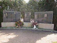
A sub-camp of the Neuengamme concentration camp was set up on the grounds of the Engerhafe parish garden in October 1944 . About 2000 people were housed here in the most deplorable conditions. In connection with the construction of the so-called Friesenwall, they were supposed to create an anti-tank ditch around the town of Aurich. The camp was closed again at the end of 1944. Almost 200 people died here between October and December 1944. A museum in the Engerhafe rectory reports about it.
literature
- Manfred Meinz : The church to Engerhafe ( Ostfriesische Kunstführer , issue 1). Aurich 1962
- Robert Noah: The Church of Engerhafe (Ostfriesische Kunstführer, issue 14). Aurich 1989
Web links
- Brookmerlandarchiv - The old Brookmerland in pictures from bygone times
- There are hardly any traces of the Engerhafe concentration camp ( memento from March 31, 2004 in the Internet Archive )
Coordinates: 53 ° 29 ′ N , 7 ° 19 ′ E


