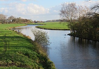
Fehntjer low
| Fehntjer low | ||
|
Below the viewer the Fehntjer Tief West from the direction of Emden , |
||
| Data | ||
| Water code | DE : 3943, 3945, upper reaches 3941 u. 3942, western arm 3946 | |
| location | East Frisia , Lower Saxony , Germany | |
| River system | Ems | |
| Drain over | Ems → North Sea | |
| origin | Confluence of the northern and southern arms of the Fehntjer low, northeast of Timmel 53 ° 22 ′ 15 ″ N , 7 ° 29 ′ 2 ″ E |
|
| Source height |
2 m above sea level NHN ; western arm: Kesselschleuse in Emden 53 ° 22 ′ 1 ″ N , 7 ° 13 ′ 9 ″ E , 1 m above sea level. NHN |
|
| muzzle | Oldersumer Siel Coordinates: 53 ° 19 ′ 25 " N , 7 ° 20 ′ 34" E 53 ° 19 ′ 25 " N , 7 ° 20 ′ 34" E |
|
| Mouth height | 0 m above sea level NHN | |
| Height difference | 2 m | |
| Bottom slope | 0.08 ‰ | |
| length | specifically 23.6 km, hydrographically 28.3 km |
|
| Catchment area | 235.09 km² | |
| Left tributaries | Calf intestines, Heuwieke | |
| Right tributaries | Hüllener Wieke, Krummes Tief, Kiefgatt, Sengelsieltief, Blitz, Stinkende Riede, Neues Tief | |
| Medium-sized cities | Emden | |
The Fehntjer Tief is a river in East Frisia . The Fehntjer Tief leads from the community of Großefehn in the Aurich district in a westerly direction to Emden . Drainage takes place through the Oldersumer Sieltief . In the western part, the water flows eastwards (contrary to what is shown in most maps). Large parts of the interior of East Frisia are drained via the Fehntjer Tief; Boat tourism is also of great importance, since the deep can also be navigated for the most part by motorized boats. The Fehntjer Tief uses the former Flumm river in sections and was considerably widened in the course of the Fehn colonization.
course
Spring waters
The Fehntjer is fed by two arms, the northern and southern Fehntjer low. These two upper courses converge exactly at the point where the communities of Großefehn and Ihlow and Moormerland meet. There are many oxbow lakes that are heavily overgrown.
The northern headwaters has been identified as the more important, as the upper reaches of the lower part (TVC: 39411) of the Flumm and as its "source stream" of Grenzgraben between Großefehn - Wrisse and Aurich-Oldendorf , TVC: 3,941,111th This, however, has no source but is a pseudobifurcation origin , which is fed from the surrounding fields and meadows. To the west it is connected by a culvert under the confluence of the (upper) Flumm (GKZ: 39212) and Alter Flumm (GKZ: 39211) to the Sauteler Canal (GKZ: 392) with the lower part of the Flumm. The eastern part of the border trench is connected to the Alte Flumm by a short body of water called Groote Leegde. It is 10.4 km from the origin to the confluence.
The southern upper reaches is a total of 6.7 km long and is called Bagbander Tief from the Timmeler Meer upwards . It begins with the Neuefehn Canal (GKZ: 39421) in Bagband origin .
Middle course
From the confluence of the Northern and Southern Fehntjer Tief, the water has a strongly meandering, naturally formed course and flows through the nature reserve Flumm / Fehntjer Tief, which extends north and south of the river. This pastureland is only used extensively. As a result, the Fehntjer Tief crosses under the A31 and takes on other smaller canals and drainage ditches from the north and south. From the confluence of the north and south arms to the start of the Oldersumer Sieltief, the flow path is 13.4 to 13.5 km.
Lower course

The lower course through which most of the water reaches the Ems is formed by the equally tightly meandering Oldersumer Sieltief , up to the Sieltor 4.14, up to the ems bank line 4.44 km long.
Western arm
To the west of the transition to the Oldersumer Tief, the Fehntjer Tief continues to Emden. This section is artificially created, recognizable by its predominantly straight course. At the Petkumer Sieltief the course is offset because the westernmost section of the Fehntjer Tief was connected further north there. Nowadays, the Petkumer Sieltief contributes little to drainage. However, as a traffic route it creates a connection with the Ems Lateral Canal . The direction of current in the 10.1 km long western parts of the Fehntjer Depression is normally eastward.
Recreational boating
At the boiler lock in Emden, the low connects with the Ems-Jade Canal , the Emden Stadtgraben, which runs around the city center, as well as an extension of the Faldernelft and thus the Emden harbor. From there there is a connection to the Ems and thus to the North Sea through locks.
Motorboat trips are possible from Emden to Timmeler Meer . A trip to Wiesmoor is feasible via the Nördliche Fehntjer Tief and the canals in the center of Großefehn - but only with canoes and kayaks or smaller boats up to a certain construction height due to the low, rigid bridges. From Wiesmoor it is possible to travel to Oldenburg and thus to the Weser via the Nordgeorgsfehn Canal and other canals and rivers .
Individual evidence
- ↑ Drawn GPS tracks Fehntjer Tief (Grenzgraben to Oldersumer Siel) , Fehntjer Tief Südarm , Fehntjer Tief West
- ↑ Environment Lower Saxony: Area Directory Ems (PDF; 221 kB)
- ↑ a b Lower Saxony environmental maps , Layer Manager → Hydrology → Water network
