North Georgsfehn Canal
| North Georgsfehn Canal | |
|---|---|
|
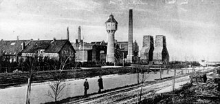
The Wiesmoor peat power plant in 1910, the Nordgeorgsfehn Canal in the foreground |
|
| abbreviation | NGFK |
| location | Germany: Lower Saxony |
| length | 31.8 |
| Built | 1820-1916 |
| class | 0 (approved for vehicles up to 22 m length, 5.25 m width, 1.4 m draft) |
| Beginning | Branch from the Ems-Jade Canal 53 ° 27 ′ 44.7 ″ N , 7 ° 43 ′ 6.1 ″ E |
| The End | Transition to Jümme 53 ° 13 ′ 17.8 ″ N , 7 ° 38 ′ 14.6 ″ E |
| Descent structures | 8th |
| Kilometrage | km 0 to km 31 |
| Downhill | Towards Jümme |

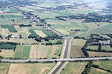
The Nordgeorgsfehn Canal (NGFK) connects the Jümme with the Ems-Jade Canal . It is 31.8 km long, 13 m wide and allows a draft of 1.4 m and a passage height of 2.2 m. It has eight locks and fifteen fixed and ten movable bridges.
The owner is the state of Lower Saxony and the canal is operated by NLWKN .
history
The southern section of the canal was built in the 1820s and stretched from the Jümme near Stickhausen through the moorland to Nordgeorgsfehn . This section was completed by 1829 and called "Stickhauser Canal".
The other sections, always planned only in small sections, via Remels to Neudorf in the municipality of Uplengen , and later (between 1906 and 1916 ) to the Ems-Jade Canal near Marcardsmoor north of Wiesmoor were carried out by the moor colonists, which made the expansion possible delayed.
Course and water levels
The canal branches off northeast of Stickhausen from the Jümme ( 53 ° 13 ′ 17.8 ″ N , 7 ° 38 ′ 14.6 ″ E ).
The first section between the Jümme and the lock at Nordgeorgsfehn is tideabhängig and lies between mtnw m and NN +0.30 MTHW NN +1.20 m. From there to the lock “NGDFK VI Wiesmoor Zentrum” the water level rises to +9.00 m above sea level, and then to the level of the Ems-Jade Canal at lock “NGDFK VII Wiesmoor Nord” from +5.70 m above sea level to sink. At the eighth lock “NGDFK VIII Marcardsmoor” ( 53 ° 27 ′ 44.9 ″ N , 7 ° 43 ′ 3.8 ″ E ) there is no height difference. It is only for security and is always open.
use
The expansion served to drain the large raised bog areas in the southern district of Wittmund and to provide transport links to the bog colonies that arose around 1900 in the Wiesmoor area. Mainly peat and coal for the power station in Wiesmoor were transported on the canal . Freight shipping ceased in 1962 . Since then, the canal has only been used by pleasure boats, for which it forms a connection between the Weser , Ems and Jade .
Another function of the canal is depth management . The water obtained by pumping stations at the five southern locks flows to the Ems-Jade Canal, where it is used to raise the low water level .
Individual evidence
- ↑ a b c The Nordgeorgsfehnkanal (NGFK) from Marcardsmoor to Stickhausen Leaflet of the NLWKN (PDF; 1.6 MB)

