
Joint municipality of Hage
| coat of arms | Germany map | |
|---|---|---|

|
Coordinates: 53 ° 36 ' N , 7 ° 17' E |
|
| Basic data | ||
| State : | Lower Saxony | |
| County : | Aurich | |
| Area : | 68.64 km 2 | |
| Residents: | 11,200 (Dec. 31, 2019) | |
| Population density : | 163 inhabitants per km 2 | |
| License plate : | AUR, NOR | |
| Association key : | 03 4 52 5403 | |
| Association structure: | 5 municipalities | |
| Association administration address : |
P.O. Box 1160 26524 Hage |
|
| Website : | ||
| Mayor of the municipality : | Johannes Trännapp (independent) | |
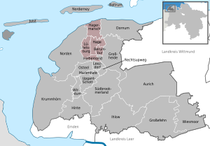
| Location of the joint municipality of Hage in the Aurich district | ||
  |
||


The joint municipality of Hage is, alongside the joint municipality of Brookmerland, one of the two joint municipalities in the East Frisian district of Aurich . It consists of the member communities Hage , Berumbur , Halbemond , Lütetsburg and Hagermarsch . The establishment of the joint community goes back to 1965. The regional body received its present form in the course of the Lower Saxony administrative and regional reform of 1972. Its seat is in the patch of Hage.
The area of the joint municipality of Hage covers an area of 68.64 km². 11,200 people live there, which corresponds to a density of 163 people per km². This means that the entire municipality is slightly above the comparative value for East Frisia (148.6) and slightly below that of Lower Saxony (168), but clearly below the national average (around 230). Your member municipality Hagermarsch is the most sparsely populated municipality in East Frisia .
Compared to other East Frisian municipalities, the joint municipality of Hage is heavily forested. The forests are mainly located in the municipality of Lütetsburg, but also in Hage and Berumbur. Otherwise, the landscape of the municipality is characterized by the marshland and the Geest .
Lütetsburg Castle and its park, Nordeck Castle and Berum Castle , as well as Germany's highest windmill with a 30.8 m cap height, are part of the cultural heritage of the integrated community .
geography
Position and extent
The main town Hage is located about 5.5 kilometers from the western Norder city center. The distance to the southeastern district town of Aurich is almost 20 kilometers. The straight line distance between the patch and the city of Emden is around 27 kilometers to the south. The closest major city, Oldenburg , is around 80 kilometers to the south-east.
The largest extension in north-south direction, between the dike line at Hilgenriedersiel and the border with the municipality of Brookmerland at half moon, is about 12.3 kilometers. In the east-west direction, the maximum extent is only about 7.6 kilometers, between the border to the north in Lütetsburg and Blandorfer Ehe, which forms a section of the border to the neighboring municipality of Großheide to the east.
The joint municipality is located in the historic Norderland landscape . With an area of 68.64 km² it is one of the smallest municipalities among the integrated municipalities and those unitary municipalities of East Friesland that do not belong to an integrated municipality. It ranks 26th among the largest municipalities in East Frisia , only Ostrhauderfehn , Hinte and all East Frisian Islands are smaller in area. With a population of around 10,700, there is a population density of 156 inhabitants per km², which means that Hage is slightly above the East Frisian average of 148 inhabitants / km², but below the Lower Saxony (167) and German (229) average.
Geology, soils and hydrology


The combined community has shares in the three typical landforms of the East Frisian mainland: marshland , geest and moor . Geologically, the municipality of Hage, like all of East Friesland, is formed superficially by layers of the Pleistocene and Holocene . Pleistocene strata can be found in the Geest areas that make up the southern part of the Samtgemeinde area. Part of the geest layers are covered with bog, a Holocene layer. The soils of the East Frisian Geest mostly consist of deck sands and boulder clay .
The center of the integrated community area around Lütetsburg, Hage, Berum and Blandorf-Wichte consists of podzol soils on Orterde or Ortstein , either in a drier or in a wetter location. These soils allowed only low agricultural yields. Due to pest fertilization , which was carried out for centuries until the appearance of artificial fertilizers at the end of the 19th century, there are pest soils, especially in the area around the old Geest villages . Due to the constant application of new soil, the Esch, known in East Friesland as (the) guests, is now higher than the village center. This form of fertilization increased the soil value significantly, even if it still lagged well behind the fertile soils of the marshland.
The north of the municipality, i.e. the municipality of Hagermarsch, consists largely of sea marshes . The polder soils are primarily Kalkmarsch and Kleimarsch soils made of clay and silt of high productivity. In the old polders, which were diked in before the 18th century, soil weathering through decalcification and acidification has already progressed further. The descaling depth is around 30 to 70 centimeters.
Neighboring communities
The area of the municipality of Hage is bounded in the north by the North Sea . In front of the coastline is the eastern part of the island of Norderney . The municipalities of Dornum and Großheide lie on the eastern border of the integrated municipality . It shares its southern border with the communities Leezdorf and Osteel in the joint municipality of Brookmerland and the western border with the city of Norden . All the municipalities mentioned belong to the Aurich district.
Joint community structure
The combined community consists of five member communities, four of which in turn consist of the eponymous main towns and other subsidiary towns.
| Member parish | Residents | Area (km²) | associated districts |
|---|---|---|---|
| Berumbur | 2773 | 6.42 | Holzdorf , Kleinheide |
| Half moon | 1005 | 6.55 | - no more - |
| Spots Hage | 6272 | 16.62 | Berum , Blandorf , Hagerwilde, Wichte |
| Hagermarsch | 431 | 22.32 | Hilgenriedersiel , Junkersrott , Theener |
| Lütetsburg | 719 | 16.73 | Moorriege |
| total | 10,702 | 68.64 | - |
The municipalities of Berumbur, Halbemond, Hage, Hagermarsch and Lütetsburg merged to form the Hage municipality during the Lower Saxony municipal reform in 1972 . While most of the smallest communities in East Friesland joined together to form unitary communities, the communities in the present area at the time voted for the formation of a joint community. Hage, making it one of the time eight, since 2001, only six joint communities in East Friesland. At the time of the regional reform, all municipalities had failed to meet the target of at least 5000 inhabitants for the formation of a unified municipality, which the state government at the time considered to be decisive.
Land use
| use | Hectares |
|---|---|
| Building and open space | 582 |
| including living space | 427 |
| of which commercial and industrial space | 33 |
| Operating area | 15th |
| Recreation area | 111 |
| including green area | 84 |
| traffic area | 303 |
| of which road, path, square | 288 |
| Agricultural area | 4,745 |
| Water surface | 133 |
| Forest area | 872 |
| Areas of other use | 103 |
| including cemeteries | 5 |
| of it land | 10 |
| total area | 6,864 |
The land use table shows the high proportion of agricultural land in the Samtgemeinde Hage: It is 69.13 percent. This means that the entire municipality is below the East Frisian average of around 75 percent. In comparison with the rest of Germany, however, the proportion of agricultural land is high; the average in Germany is around 52 percent.
The combined municipality has the largest proportion of forest areas in the total area among the East Frisian municipalities. It is 12.7 percent and thus about one or two percentage points higher than in the two municipalities with the second and third largest share, Friedeburg and Aurich . Lütetsburg contributes to a large extent to this fact. North of the state road is the north wood, south of the Lütetsburger Park the big wood. Tidofelder Holz can also be found in the southwest of the Lütetsburg district. In the Flecken Hage, in a small area also in the Halbemonder district, there are parts of the large wood. In addition, the Fürstenwald south of Berum Castle (probably built in the middle of the 17th century) and the Julius grove north of Nordeck Castle can be found in the area. Parts of these two forest areas are also in the Berumbur district. In the south of the district of Kleinheide in the member municipality of Berumbur there are also two more forest areas. The member community Hagermarsch, on the other hand, is completely free of trees, apart from tree-lined streets and trees near the courtyards. One of the special features of the forest areas in the Samtgemeinde is that they - together with a forest in Moorweg ( Samtgemeinde Esens ) - form the northernmost forest areas in East Frisia, with the northernmost point only about 4.5 kilometers behind the sea dike.
Water bodies make up about 1.94 percent of the total municipality area. This means that the area in question lies quite precisely within the national average of two percent. In a comparison between East Frisia, however, Hage is rather poor in water bodies.
climate
The municipality is located in the temperate climatic zone, influenced by the North Sea . In summer the daytime temperatures are lower, in winter often higher than in the further inland. The climate is characterized by the Central European west wind zone.
After the climate classification of Köppen , the community is in the classification Cfb . (Climate zone C : warm-temperate climate, climate type f : humid-temperate climate, sub-type b : warm summer ). Within the temperate zone, it is assigned to the climate district of Lower Saxony flatland North Sea coast , which has a maritime character and is characterized by relatively cool and rainy summers, relatively mild winters with little snow, prevailing westerly and south-westerly winds and high annual rainfall.
Protected areas
In the north, the municipality borders the Wadden Sea and thus the Lower Saxony Wadden Sea National Park , which, together with the other German and Dutch parts of the Wadden Sea, was declared a World Heritage Site by UNESCO in June 2009 . The border of the national park is the main dike line, so that the offshore Heller is also part of the national park. The area around Berum Castle has been designated a landscape protection area since 1965. It is just over three hectares in size. Protected landscape components include the Kolk on the border between Hage and Hagermarsch (under protection in 1990, about 0.5 hectares in size), three ponds in the Julius grove in Hage (under protection in 1989, around two hectares in total), the pond and swamp area on Kolkweg in Berumbur / Holzdorf (under protection 1989, a little more than two hectares in size) and several trees in the Julius grove with a total size of less than one hectare (under protection 1990). Two solitary trees in the Hage area are added as natural monuments.
history
Prehistory and early history
Along the Geestrand, which runs roughly from the north via Lütetsburg, Hage, Arle and Westerholt to Esens , a path already ran in the Bronze Age. This is the conclusion reached by archaeologists who, as early as the 1950s , examined the Bronze Age network of trails in the region using barrows and other artifacts found , in particular their spatial concentration.
middle Ages
Hage was probably built at the end of the 12th century on an old trade route from the Bronze Age. The first settlements were found on the so-called “Hagherweg”: Hilgenbur and Vnuggenbur.
Reports of monastic life in Hage can be found as early as the early 13th century. Initially a Benedictine monastery was built, but the existence of the St. Anne's monastery, which was probably abandoned in 1235, cannot be clearly proven. From the middle of the 13th century, the nuns were followed by a Dominican monastery .
The Ansgari Church was completed as early as 1250 . To this day it dominates the townscape of the patch.
However, Hage was first mentioned in a document after 1400 as Haghene, Hagha or Haghe, which means something like "closely related". The name Hage can be found for the first time in the East Frisian document book around 1410.
Chief time
The East Frisian noble family Hinkena is of particular importance for the development of the town of Hage. With her castle in Hage she secured the old trading center. In 1466 the castle and the lands belonging to it became the property of the church and for many centuries served to finance a second pastor in Hager, the so-called Westerpastorei.
There were also other chiefs' seats in what is now the Samtgemeinde area. One of them was Wichte, the ancestral seat of the chief family von Wicht, which is proven around 1400 in the district of the same name. The progenitor of that family was Imel von Wicht (e) ("Imel to Wicht"), who was also chief in Lintel near the north.
In the 15th century inherited Cirksenas the Berum Castle . Count Ulrich I had the existing castle expanded into a palace in 1443 and celebrated his wedding there on June 1, 1455 with Theda , the granddaughter of his great rival Focko Ukena .
Under the counts and princes Cirksena (1464–1744)

On October 1, 1464, Emperor Friedrich III. Ulrich Cirksena to the imperial count status. In the award certificate, Ulrich is named as the master of "wonung, wesen and sloss Norden, Emeden , Emesgonien, with the siessen Gretzil , Berum , Aurike , Lerort and Stickhausen (...)". The present area in the Norderland , from which the Cirksena family originally came , also belonged to the more precisely defined dominion area .
After the Cirksena had been granted the dignity of count, they began to divide their territory into individual administrative units, and an office structure was created . The counts used the existing castles in East Friesland as central contact points, including Berum Castle. The Berum office was created, which roughly encompassed the area of what is now the joint municipality of Hage (without the glory of Lütetsburg at that time) as well as the municipality of Großheide and the western parts of the municipality of Dornum around Nesse .
In the late 16th century, Count Edzard II had Berum Castle expanded into a moated castle, which was completed in 1591. After his death, his widow Katharina, the daughter of the Swedish King Gustav Wasa , added some extensions to the palace. In the following years the former castle or chateau served as the widow's seat of the Cirksena family.
In the course of the Saxon feud between Edzard I. Cirksena and Georg von Sachsen , Hage, Berum and the surrounding area were also affected. Haico von Wicht, grandson of the Wichter Chief Imel to Wicht, was at that time Drost at Berum Castle and defended it against Hero Omken , who was an ally of Georg von Sachsen, and Chief of Harlingerland . However, the Wichte castle itself was destroyed by Omken.
On January 28, 1600 was on the Berum Castle of Berumer comparison signed, which in consequence of Harlingerland finally came to East Friesland.

During the Thirty Years War , East Frisia was captured three times (1622-1624, 1627-1631 and 1637-1651) by foreign troops and used as quarters, even if no major fighting took place. From 1622 to 1624 the Mansfelder occupied East Frisia. The places in the area suffered from the occupation by the troops. The two following occupations also meant burdens through contributions. The occupiers from 1627 to 1631, however, imperial troops under Tilly , “kept male discipline and avoided excesses”, as did the Hessian troops billeted in East Frisia from 1637 to 1651 under Wilhelm V von Hessen-Kassel . Materially, too, the situation was different under the two occupations than under Mansfeld: Although contributions were collected, these were also spent in the region. During the war, the plague broke out in East Frisia , but deaths for the area in question are not documented. During the occupation by imperial troops (1627–1631), however, there was a momentous incident for the East Frisian Count House, which took place at Berum Castle: On April 17, 1628, the 26-year-old Count Rudolf Christian died while he was in the process of one - caused by drunkenness - was fatally injured by a lieutenant of the imperial general Gallas by a stab in the left eye.
Hage received market rights in 1656 and from then on could call itself “market town”. According to the princely charter awarded at the time (September 11, 1656), Hage was allowed to hold two markets per year. This tradition continues to this day.

The area in question was severely affected by the Christmas flood of 1717 . According to a contemporary survey by the preacher Jacobus Isebrandi Harkenroth, more people died in the Berum office and the glory of Lütetsburg, i.e. in the area of the Samtgemeinde and the neighboring municipality of Großheide, than in all other East Frisian offices with the exception of Esens. 645 fatalities were counted. More than 400 horses, around 1600 cattle, more than 650 sheep and more than 200 pigs drowned in the floods. In addition, there were 211 completely and 255 partially destroyed houses.
In the aftermath of the Christmas flood, there was an appeal war between the East Frisian dynasty and the so-called renitents, who fought under the leadership of the city of Emden over the distribution of the tax burden. At the end of this conflict, which lasted around three years, a battle took place near Hage, in which the unruly troops were defeated by the princely who had called for help from Denmark. In the battle on April 5, 1727, the rebels lost all of their artillery and were driven to flight.
Half moon is mentioned for the first time in 1731. Warfs people from the Berum office settled in the local moor. The name is based on a mistranslation from Low German: The original name "half Mahn" meant "Halbgemeinschaftsländerei", but in High German it became "Halbe (r) Mond" due to its similarity to the Low German word for "moon" of the same name.
Prussian period (1744–1806 / 15)
During the Prussian period, the Hage area represented the commercial center of the present area and, along with Nesse, was by far one of the two largest in the Berum district. While 61 craftsmen and merchants were registered by the Prussian administration in Hage in 1756, there were 58 in Nesse . Arle followed by a long way with 25. Among the 61 craftsmen and shopkeepers there were eight merchants. One of them traded primarily in cloth goods, the other in food of all kinds. The craftsmen included eleven linen weavers, ten cobblers, eight carpenters, five bakers, four blacksmiths, three cooperatives, two barbers, glaziers, wheel makers and tailors as well One carpenter and one bricklayer each.
In order to supply the city of Norden and the hamlet of Hage with peat , citizens from the city and the hamlet set up a fen colony at the end of the 18th century, the first and only bog colony in the area of the old district of the north that was accessible through a fen canal. The Berumer Fehngesellschaft received from the state on April 4, 1794 a long lease agreement for an area of 1500 Moordiemat , which corresponds to about 1500 hectares. Since then, the year has been considered the founding year of Berumerfehn. In 1794 the construction of the Berumerfehn Canal began, which extends from the Norder Tief to the high moor near the fen colony. The excavation was done by around 160 workers from the Oldenburg region , as East Frisian workers refused to take over the construction work. Here the influence of the pool yachts became clear, who resisted the competition from the newly founded fencing company (ultimately unsuccessful), because the colonies of Ostermoordorf and Westermoordorf established by the pool yachts are in the immediate vicinity of Berumerfehn. The fen colony soon supplied not only the north but also Hage with peat.
After the battle of Jena and Auerstedt in 1806, East Friesland and with it the present area was incorporated into the Kingdom of Holland and thus into the French sphere of influence. In 1810, the Ems-Orientale (Osterems) department became part of the French Empire, and in 1813, after the Wars of Liberation, Prussia was briefly re-established. After the Congress of Vienna in 1814/15, Prussia ceded East Frisia to the Kingdom of Hanover.
Hanoverian and Imperial Era (1815–1918)
In the early 19th century (1817-1819) Hage received a paved stone road for the first time. Where previously there was only a narrow, tree-lined and often hardly passable “Hagherweg”, a new road was created, which was important as a post route from the north via Hage and Westerholt to Esens and Wittmund. Because of this, there were many inns in Hage at that time.
In the early 19th century, Hage and the surrounding area were considered to be an agriculturally productive area due to the good soil on the edge of the marshland, in which farmers had to fertilize comparatively little. Mainly rye and flax were grown. The agricultural products, in addition to those mentioned, also rapeseed, butter and wheat, were mainly sold in the north, but also in Aurich and partly also shipped via Neßmersiel and Dornumersiel .

Berum remained the seat of an office even in Hanover. This included the bailiwicks of Berum, Nesse and Norderney and thus in addition to the two islands of Norderney and Baltrum and the western area of today's municipality of Dornum also the area of today's municipalities of Hage (Bailiwick Berum) and Großheide (Bailiwick Arle), but without the still independent Glory Lütetsburg. The Bailiwick of Berum was divided into the sub-Bailiwicks Hage and Hufschlag. While the former comprised the more densely populated south of today's Samtgemeinde area, the former was responsible for the sparsely populated, but extensive north. The area of Hage counted 835 inhabitants together with Berum in the early 1820s. At the same time there were 78 inhabitants in Blandorf and 75 in Wichte. Berumbur and Kleinheide had 594 inhabitants at the same time, and Halbemoon had grown to 261 inhabitants less than a century after the settlement began. The Hagermarsch with Junkersrott and Theener came to 383 residents, who were spread over many farms. The moorland south of Hage, also known as Hagerwilde, was settled from 1831. During an office reform in 1852, the former glory Dornum came to the office of Berum. Only seven years later the Hanoverian state reformed the office structure again and merged the offices of Berum and Norden. The seat was initially Berum, but in 1869 it was moved to the north, ending a 300-year history of Berum as the official seat. The enlarged office was named after the new seat. North from office in 1885 was county north , which now also belonged to the present area.

From 1862 to 1864 the landowner Edo Friedrich Peterssen had Nordeck Castle built. Another building that dominates the townscape is the eight-story Hager Windmühle , an eight-sided gallery Dutch with a five-story brick substructure. With a height of 30.20 meters to the top of the cap, it is today the tallest windmill in Germany and one of the tallest in Europe. It was built in 1872/73 as the successor to a previously existing mill, and after a fire in 1880, one floor was added. The landowner Edo Friedrich Peterssen was again the initiator. The mill was deliberately built at its current height so that it was high enough to be able to use the North Sea wind despite the surrounding forest areas. Peterssen also promoted road construction and in 1881 donated a house to the north office that came from the inheritance of his aunt Helene. He made it a condition for the office to set up a hospital there, which was named after his aunt Helenenstift. The house served as a district hospital for the north district until 1948, then (and to this day) as a senior citizens' home.
Hage's transport infrastructure was not significantly improved until the second half of the 19th century. Between 1860 and 1880 the post route from Hage via Arle to Westerholt (today's Landesstrasse 6 ) was paved with clinker bricks . With the construction of the East Frisian Coast Railway , Westerende received a train station.
Throughout the 19th century and into the 20th century there were great social and economic differences between rich large farmers and poor farm workers. For Hage (especially Hagermarsch) it can be stated what also applied to other East Frisian marching communities such as the Krummhörn : "During the march, the social differences were particularly sharp and harsh: On the one hand, tough and proud farmers, gentlemen through and through, on the other hand the day laborers. They also do not resemble the tribe and the peasants in pride below, but are economically oppressive. ”Reports from farm workers say that the working days lasted from 4 a.m. to 6 p.m., interrupted by a one and a half hour lunch break. The farm workers often slept with the cattle in the stable if they did not have their own (and if they did, usually a very poor) little house.
At the end of 1914, the Imperial Navy built the Hage airship port due to its strategic location immediately north of the town, which was completed by 1915 with four large airship hangars. Hage was one of the main attack bases of the airships against Great Britain in the First World War . In 1917, the airships were moved further inland due to increasing air attacks by Allied airmen. The halls had to be demolished in 1921 in accordance with the provisions of the Versailles Treaty . The area was used again by the Luftwaffe from 1937.
Weimar Republic
In April 1919 there were so-called "bacon parades" by Emden workers , followed by rioting on the farm workers and similar raids in the Rheiderland . Workers broke into the surrounding villages in closed trains and stole food from farmers in clashes. The situation only calmed down after the deployment of the Reichswehr troops stationed in the region . As a reaction to this, resident police formed in many places in East Friesland - including those that were not affected by the “parades” . The weir in Lütetsburg comprised 99 people who had 56 weapons, making it the largest village weir in the Norderland. Two other resident guard was formed in Blandorf (16 people) and Berumbur (54 people), but apparently only late, so that weapons were "requested", but nothing is known about the implementation of this request. The resident services were only dissolved after a corresponding decree by the Prussian Interior Minister Carl Severing on April 10, 1920.
As in the entire north-west of Lower Saxony, the rural people's movement was given a boost in the Weimar Republic after a bad harvest occurred in 1927 and the farmers were increasingly in dire straits. However, by focusing on quantities rather than quality, the problems were partly homemade. As in other parts of the country, the black flag, symbol of Florian Geyer's Black Band in the Peasants' War , fluttered as a sign of protest. On January 5, 1928, there was a large demonstration by farmers from the region in Aurich, in which 4,000 people took part. The National Socialists, with their blood and soil ideology, saw themselves as guardians of the needs of the farmers and found appropriate support in many communities.
In contrast to many other moor and geest areas in East Frisia, the voting behavior of the inhabitants of the present area was very inconsistent during the Weimar Republic. In line with other towns in the region, however, the proportion of right-wing extremist or fascist parties increased during the years up to 1933.
National Socialism
During the time of National Socialism, there were prisoner-of-war camps with prisoners from France and Belgium, among others , in the municipality . The location of one of the prison camps was the Sophienhof inn .
The farmers in the municipality were in the Reich into line . The passing of the Reichserbhofgesetz met with protests from many farmers, as they felt that their economic freedom of choice was limited. In the bog colonies such as Halbemond or Hagerwilde there was also the fact that the agricultural properties were often too small to represent a full-time farm. The ban on selling hereditary farms therefore hit those businesses with the lower size limit of a hereditary farm of 7.5 hectares in particular. Although there were many judicial judgments in favor of the plaintiff smallholders, the proportion of hereditary farms in the region remained above the national average.
post war period

Along with a structural change at the beginning of the 1960s, the share of the labor force in agriculture fell to 30.2 percent in 1961 and to 26.1 percent in 1965. Small family farms disappeared rapidly. New roads and farm roads were built and the first wind turbines to generate electricity were installed.
In October 1963 the new town hall was inaugurated. In 1965, Hage merged with Berum, Blandorf-Wichte, Lütetsburg and Westdorf to form the joint municipality of Hage. Berumbur (with Holzdorf, Kleinheide, Hagermarsch, Halbemond and Junkersrott) was incorporated into the joint municipality of Hage in 1971. In 1977 the northern district was integrated into the Aurich district , to which the integrated municipality has belonged ever since.
After both the passenger transport of the German Federal Railroad in 1983 and the freight train operation in 1989, an operator association for the museum train on the coastal railway was founded. This museum train now stops at the former Hager train station.
In the 1980s and 1990s, Hage developed into a rural center with shopping and leisure areas. The municipalities of Berumbur, Hage and Lütetsburg have been officially recognized as climatic health resorts since 1982 . In 2006 the former Hager train station, which was damaged by the fire in the roof structure, was demolished. In the same year the construction of the relief road began, which was completed in 2010.
politics
The integrated community of Hage has been - like East Frisia in its entirety - a stronghold of the SPD for decades. As early as the 1949 federal election, the Social Democrats won the most votes in all of the municipalities that make up today's integrated municipality. In Lütetsburg, Hage and the then still independent municipalities of Berum and Blandorf-Wichte, the share was between 30 and 40 percent, while the SPD even achieved an absolute majority in Hagermarsch, Berumbur and Halbemond. The CDU, on the other hand, which organized very late in East Friesland (with the exception of the district of Leer), only exceeded ten percent in Berum, and remained below that in all other communities. In the federal elections in 1953, nothing had changed in the supremacy of the SPD in what is now the integrated municipality: In almost all municipalities, the Social Democrats won a relative or (half moon, Berumbur) even an absolute majority. Only in Blandorf-Wichte did the right-wing German Reich Party become the strongest force. The 1969 Bundestag election, which brought the CDU votes in East Friesland, also left its mark on the joint municipality: it won an absolute majority in Berum and Blandorf-Wichte and a relative majority in Halbemoon. In Blandorf-Wichte, the NPD also achieved a share between 15 and 20 percent. In the "Willy Brandt election" in 1972 , which brought the SPD a record result in East Friesland, it won an absolute majority everywhere with the exception of the Berum and Blandorf-Wichte electoral districts, and in both of these places it went to the CDU. Little changed in the dominance of the SPD in the following decades. In the 2005 Bundestag elections, the SPD became the strongest party in the municipality, as did in 2009.
Joint council
The Samtgemeinderat of the Samtgemeinde Hage consists of 26 councilors. This is the specified number for a joint municipality with a size between 6001 and 7000 inhabitants. The 26 council members are elected for five years each by local elections. The current term of office began on November 1, 2016 and ends on October 31, 2021.
The last local election on September 11, 2016 resulted in the following:
| Political party | Proportional votes | Number of seats | Change voices | Change seats |
|---|---|---|---|---|
| SPD | 48.89% | 13 | −5.18% | −1 |
| CDU | 31.25% | 8th | + 5.41% | +1 |
| Alliance 90 / The Greens | 7.01% | 2 | −2.57% | 0 |
| VBL (Free Voters (Lütetsburg)) | 9.56% | 2 | + 3.07% | 0 |
| FWG (Free Voters (Joint Community)) | 3.27% | 1 | −0.72% | 0 |
The turnout in the 2016 local elections was 58.82%, above the Lower Saxony average of 55.5%. For comparison - in the previous local election on September 11, 2011, the turnout was 55.14%.
In the recent past there has been a push by Mayor Johannes Tränapp to convert the municipality into a unified municipality , as did the neighboring municipality of Dornum and the former municipality of Bunde in the Leer district in 2001 . The VBL electoral group, which has an absolute majority in the Lütetsburg Council, but only has two seats in the Samtgemeinderat, rejected this proposal immediately.
Joint mayor of the municipality
The full-time mayor of the joint municipality of Hage has been Johannes Tränapp (born April 1, 1956) since November 1, 2006. Tränapp previously worked as managing director of the DRK district association Aurich. Before his election as mayor of the joint municipality, the social democrat was a member of the joint municipality council for five years. He prevailed in 2006 with 57.44 percent of the votes against his rival Burmeister (CDU, 42.55 percent). In the last joint mayor election on May 25, 2014 Trännapp ran again and was re-elected with 58.78% of the votes. His opponent Sven Behrens (CDU) received 41.21%. The turnout was 55.59%. Trännapp began his further term in office on November 1, 2014.
Representatives in the Land and Bundestag
The integrated municipality of Hage belongs to the state electoral district of Emden / Norden , which consists of the city of Emden, the city of Norden and the municipalities of Krummhörn , Hinte and the integrated municipality of Hage. In the Lower Saxony state parliament ( legislature from 2017 ) two members are represented in the constituency. The directly elected MP is Matthias Arends (SPD). Hillgriet Eilers (FDP) also moved into the Lower Saxony state parliament via the state list . The SPD's second vote result of 49.4 percent was again the best of this party in the 87 electoral districts of Lower Saxony.
In the case of federal elections, the municipality belongs to constituency 24 Aurich - Emden . This includes the city of Emden and the district of Aurich. In the 2017 federal election , the social democrat Johann Saathoff was directly elected. No party candidate from the constituency entered the Bundestag via the parties' list.
Coats of arms, colors and official seals
|
|
Blazon : " Blazon : divided shield, above in blue a growing, red-armored golden lion, below in gold a blue gate." |
The joint municipality bears the coat of arms of the municipality of Hage . The colors are blue and gold, which are striped on the municipality flag. The colors are identical to those of the city of Norden and indicate that the municipality is part of the Norderland . The official seal contains the coat of arms and the inscription Samtgemeinde Hage.
The coat of arms of the municipality was approved by the district president in Aurich in 1959. The lion is a reminder of the local chief family Hinkena, who led him in the shield. Their castle stood to the west of the church. The fence stands for the place name ( Hag denotes an area enclosed or fenced in with a hedge).
In addition to the coat of arms, the official seal also includes the inscription "Samtgemeinde Hage".
religion


Like the rest of the northern region, the entire community is predominantly evangelical-Lutheran . The only parish in the combined parish area has around 8,000 members. The church of the Lutheran congregation is the 13th century St. Ansgari Church , which is located in the center of the Hage area and is the only Lutheran church in the integrated congregation. The parish is divided into three parishes. The parish of Mitte includes the part of Hage to the east of Halbemonder Straße and the municipality of Berum with its district of Blandorf. The parish of Hagermarsch with its districts Theener, Hilgenriedersiel and Junkersrott also belongs to this parish . The west parish includes Lütetsburg and the part of Hages to the west of Halbemonder Straße. This pastoral care district extends to the north to the An't Hager Deep development area and to the south to the edge of Halbemond. The parish east includes the municipality of Berumbur with its districts of Holzdorf and Kleinheide and the municipality of Halbemond.
There have been significant numbers of Catholic Christians only since the time after the Second World War, when around 350 displaced Catholics found a new home in Hage. The Catholics of the integrated parish form a pastoral care office within the Catholic parish of St. Ludgerus Norden and are affiliated to the Coastal Catholic Parish Community through their main parish . Your St. Wiho Church, which was built in 1956 in part by yourself, is located on Hager Bahnhofsstraße.
From 1956 to 2006 there was also a Free Evangelical Congregation in the Hage joint congregation . Your members are looked after from the north today.
The beginnings of the New Apostolic parish in Hage go back to the 1930s. The members of the community have their church, built in 1991, on Fritz-Lottmann-Strasse in Hage. Until the inauguration of the church, the services took place in a former schoolhouse (Baantjebur 3) converted into a church. The Kingdom Hall of Jehovah's Witnesses is located on the property of the former Yellow School in the Lütetsburg member church . It is also used as a meeting place by northern members of this religious community.
The Jewish inhabitants of the Hage community belonged to Dornumer until 1863 and then - until the end of 1940 - to the Northern Jewish community .
Culture and sights
Museums and theaters


The Magda Heyken House of the local historian and teacher (1895–1972) of the same name serves as a museum with its local history collection. It houses a local history collection about the place Hage and its surroundings. The chronicler's house, built in 1959, was given to the Flecken Hage as a gift in 1972 on condition that a local archive be set up here. The opening took place in 1986. Today the Magda-Heyken-Haus houses historical files, documents, photos and paintings from Hage and the surrounding area. There is also a library and a local history collection. The community director Udo Backer, who died in 1988, provided a true-to-original model of the town of Hage as it looked in 1872.
The municipality does not have a permanent theater building. Performances by amateur theater groups, often held in the Low German language, are presented in schools or village community centers.
St. Ansgari Church
The Evangelical Lutheran St. Ansgari Church is the only historical church building in the joint parish . The church was built as a Romanesque hall church at the end of the 12th century, at the latest by 1220 . A few decades later, the Romanesque west tower was added. The long sides with their small, arched windows are structured in the upper third by pilasters, pilaster strips and round bars and are closed off by a cross-arched frieze and a German ribbon . Part of the brick building still has tuff . Today's rectangular choir is characterized by large pointed arched windows in the Gothic style and joined an original small apse at the end of the 15th century . To secure the overhanging south wall, in the 1960s the wooden beams in the ceiling were replaced by cross anchors made of concrete that looked the same and a large round arch was drawn in between the nave and the choir for cross bracing.
The baptismal font made of Bentheim sandstone comes from the time the church was built. The dominant piece of furniture is the late Gothic winged altar (around 1480), which is crowned by a large canopy. The middle field shows the crucifixion scene as a carved relief over a rocky landscape, while the framing scenes depict stations from the capture of Jesus to the resurrection. The altar probably originally belonged to Coldinne Monastery and has therefore been well preserved. Only the double doors were changed during the Reformation and lost their paintings. The altar is said to have been transferred to the church around 1580. Also between 1480 and 1490 the crucifixion group in the choir arch and the three seat on the north choir wall were created. The hexagonal pulpit from the middle of the 16th century with Ionic corner columns and a large sound cover, which is crowned by carved tendrils, is assigned to the late Renaissance . Dirk Lohman built the organ as his only new building between 1776 and 1783. The work is still in the late Baroque tradition, has 21 stops on two manuals and a pedal and is largely preserved.
Profane structures
In the Flecken Hage, the Ansgarikirche and the mill from 1873/80 (with a height of 30.8 m, the highest windmill in Germany) should be mentioned.
The Lütetsburg castle in the same community should go back to a previous building dating back to 1212 and is named after the chief Lütet Manninga from Westeel named. After the town of Westeel went under in a storm surge in the 14th century, the chief family moved to the castle, which was destroyed during the Saxon feud in 1514. The reconstruction took place in the years 1557 to 1576 under Unico Manninga . His daughter Hyma married the imperial baron Wilhelm zu Inn- and Knyphausen in 1581. With the death of Unico Manninga in 1588, the family died out, and the castle has since been inhabited by the long-established family of the Counts of Innhausen and Knyphausen and can therefore not be visited, but the associated park (see parks). After two fires in 1893 and 1956, the moated castle was rebuilt, each with elements typical of the time. It is a three-wing complex, of which the outer bailey of the previous building from 1557 to 1576 is still preserved.
In addition to Lütetsburg Castle, Nordeck Castle, which was built between 1862 and 1864, and Berum Castle can also be found in the integrated community. The latter was the seat of the Berum office for centuries. Nordeck Castle is privately owned and cannot be visited. Berum Castle is also privately owned and cannot be visited on a guided tour, but it houses a guest house.
Lütetsburger Park

According to the architectural historian and former chairman of the German Foundation for Monument Protection Gottfried Kiesow, the Lütetsburger Park is "one of the most important early landscape gardens in Germany". A Renaissance garden was laid out around the late medieval castle of Unico Manninga as early as the 16th century . The park was extended and redesigned for the first time around 1710. Edzard Mauritz von Innhausen and Knyphausen took over the next planned expansion from 1760 onwards, supported from 1790 by the Oldenburg court gardener Carl Ferdinand Bosse, who also created the residential gardens in Oldenburg and Rastede . His sons Christian Ludwig and Julius continued his work after his father's death in 1793.
Streams and ponds were created in the park. The excavation that resulted was used to model the otherwise flat landscape. The resulting Unico hill, named after the chief Unico Manninga, became one of the highest topographical elevations in East Frisia at that time. It still exists today, from there you can see far into the surrounding area. In addition to the streams and ponds, there are meadows, flowering shrubs, groups of trees and a solitary tree . In addition to native trees such as oaks and beeches, there are also exotic tree species that, according to Kiesow, “can only be found in a few historical landscape gardens today”.
In addition to the plants, there are also a number of staffage structures in Lütetsburger Park . This includes a chapel on the Unico hill, which is still used today for weddings and baptisms of the princely family. Edzard Mauritz had the "Temple of Friendship" built in memory of his friend Johann Ludwig Ransleben, a Prussian tax officer. In a pond near the Temple of Friendship, the “Isle of the Blessed” has been located since 1790 and serves as the burial place for the von Knyphausen family. Up until that point in time, the deceased members of the family were buried in the family crypt of the Bargebur Church , which was located under the Knyphausen'schen Prieche .
After bombing in World War II, the park had to be partially restored after 1945. Among other things, damage from bomb craters had been recorded. Under the direction of Wilhelm Edzard von Knyphausen, two new linden avenues were planted.
Prominent visitors to the park included Wilhelm Busch and Theodor Fontane , who wrote on the occasion of his visit in August 1882: "An ancient castle on the beach, a wonderful park in the treeless land".
Regular events
The Hager Markt is held in Hage, which goes back to the old market tradition of the town, but has meanwhile become a folk festival. Since 1981 the local festival has been celebrated with live music on the last weekend in July . The Hager Eiswette , which is based on the Bremer Eiswette , has been held every winter since 1998 . High-ranking politicians are often invited. At the summer event Gartenroute Ostfriesland , owners of 13 gardens in the communities of Hage, Großheide, Krummhörn and Hinte present their gardens, some of which are themed, including those at Lütetsburg Castle and Berum Castle. In addition to guided tours, there are also readings, concerts and workshops. In 2010 a lifestyle fair called Lütetsburger Herbst was launched in the park of Lütetsburg Palace. The exhibitors present articles from the fields of horse and dog, hunting and fishing, sport and leisure, garden and living as well as fashion. The fair has been repeated annually since then. The extreme sports event Inselschwimmen took place for the first time in July 2013 : More than 250 swimmers covered the 8.2 kilometers from the natural bathing beach at Hilgenriedersiel to Norderney, which the winner took about an hour and a quarter. The swimming competition takes place in the disciplines of monofins , swim fins and barefoot. The island swimming from the mainland to Norderney is the follow-up event to a similar competition from Bensersiel to Langeoog , which also took place annually.
language

In the joint community is East Frisian Low Saxon spoken. It is an everyday language among the adults in the integrated community. In the town hall, too, people speak flat language, but documents must be filled out in standard German. The municipality of Lütetsburg has been authorized to use a bilingual entrance sign since 2006.
Sports

The Motodrom Halbemond , a speedway arena that can hold 34,000 spectators, is one of the largest stadiums in Lower Saxony. The stadium was expanded to its current size especially for the 1983 Speedway World Championship. The German motor sportsman Egon Müller used the home advantage on September 4, 1983 and was the first and so far only German to achieve the title of speedway world champion. After that, the stadium remained unused for years, and since the turn of the millennium there have been regular speedway races again. Among other things, international competitions and predicate runs for the German Speedway Championship are held. In 2008, for the first time in 25 years, a World Championship run took place in the Motodrom as part of the Junior World Championship. The MC Norden and the terrain and motocross club Halbemond use the stadium today. In severe winter temperatures, the Motodrom serves as an ice rink.
In addition to the castle park in Lütetsburg, there has been a golf course since 2009 with one public and another reserved for a golf club, each with 9 holes. It is one of three golf courses in East Frisia, the others are on Norderney and Wiesmoor.
There are several universal sports clubs in the municipality, including SV Hage. With around 1,300 members, it is the largest of the congregation. Other universal sports clubs are the TuS Halbemond and the TSV Lütetsburg-Tidofeld. The Frisian sports Boßeln and Klootschießen are practiced in several clubs in the entire municipality . These are located in Hage, Lütetsburg, Berumbur and Theener, and there is also the Boßelverein Hagerwilde / Halbemond in both districts.
The fishing club Hage and the local branch of the DLRG are assigned to water sports . There is a shooting club in Berum and a skat club in Hage. The range of sports clubs is rounded off by the Grün-Weiß Berum and “Lütsbörger Bummert” tennis clubs in Lütetsburg.
In addition to the aforementioned speedway stadium, the sports infrastructure also includes an indoor and outdoor swimming pool in the spa center in Berum, where there is also a mini golf course, as well as the gymnasiums and sports halls of the joint community in Hage and Berumbur. The universal sports clubs also have other sports fields. The Grün-Weiß Berum tennis courts have also been laid out at the local spa center, and the Lütetsburg tennis players also have their own facility.
Economy and Infrastructure
The joint municipality of Hage hardly has any industrial operations. Tourism and agriculture are important, and the area of Hage also serves as a shopping destination for the surrounding towns. A variety of retail stores can be found there.
Separate labor market data for the entire municipality of Hage are not collected. It belongs to the north division within the Emden-Leer district of the Federal Employment Agency. In the Northern division, the unemployment rate in December 2015 was 9.8 percent. It was 3.9 percentage points above the Lower Saxony average. Five percent of employees work in the agricultural sector. In the manufacturing industry, 26 percent, in trade, hospitality and transport, 27 percent of the employees subject to social security contributions make their living. 43 percent of employees work in other service occupations (as of 2014).
tourism

The joint municipality of Hage, together with Marienhafe and Großheide, is part of the Störtebekerland tourist association . In Berum there is a holiday park with 600 bungalows and an attached spa center. The holiday park is located directly on a gravel lake . An outdoor pool can be found there. The site was converted into a spa park in 2010.
A four-star campsite was planned for a nearby lake in Blandorf-Wichte and was originally scheduled to go into operation in 2012. The plans were not implemented and the municipality bought the site back at the end of 2011. The municipality is currently looking for a new investor for the campsite that is still planned.
In May 2014, twelve caravan parking spaces were released for use near the spa center.
Agriculture
Agriculture in the integrated municipality is of great importance in the integrated municipality due to its share of land. This applies to a large extent to the member community Hagermarsch, which, in addition to traffic and residential buildings, consists almost exclusively of agricultural land. This applies to a lesser extent to the other member communities.
In the fertile young marsh soils in the Hagermarsch member community, the soils are largely used for arable farming. Wheat and rapeseed predominate among the crops, and to a lesser extent potatoes, sugar beet and special crops. Part of the agricultural land in the Hagermarsch is owned by Theelacht , an old cooperative association of landowners from the Norderland. The Theelacht is divided into eight "Theele" (shares), each of which has land. Four of the "Theele" are wholly or at least for the most part in Hagermarscher area: Linteler Theel, Trimser Theel, Ekeler Theel and Gaster Theel. The lands are leased to farmers in the respective areas.
For the most part, however, the agricultural areas in the municipality consist of grassland that is used for dairy farming. The district of Aurich is the eleventh largest milk producer district in Germany, to which the integrated community only contributes to a small extent due to its rather average size and due to the predominant arable farming in the Jungmarsch, compared to larger communities, which also benefit to a much greater extent from grassland management are shaped. Otherwise, the agricultural areas are mainly used for growing animal feed, especially maize . The maize is mainly grown for the production of silage . In addition, the cultivation of crops for the production of biogas plays a role. The sharp increase in the number of biogas plants, however, leads to an expansion of the cultivation areas for maize, which in East Frisia grew by 60 percent between 2005 and 2010. This was accompanied by an increase in the price of agricultural land for arable land and grassland by 31 and 40 percent.
Individual farms have specialized in organically produced products and have joined appropriate marketing organizations. Farmers earn additional income by installing wind turbines and biogas systems. To a lesser extent, farmers also offer rooms for holiday guests ( vacation on the farm ).
traffic

The joint municipality of Hage is located on the North Sea coast in the far north-west of East Friesland and thus off the main traffic routes. It is accessed neither by a motorway nor by a federal road, but only by two state and district roads.
The closest motorway junction is Emden-Mitte on the A31 . The junction is about 30 kilometers by road from the center of Hager. The federal road 72 , which is the main connecting road to the south for the present area , runs directly past the joint municipality area. It leads from the north via Georgsheil to Aurich. In Georgsheil there is the junction to the federal road 210 to Emden.
The Samtgemeinde area is connected to the B 72 by two state roads. The L 6 begins on the B 72 in the north and leads through Lütetsburg, the Hager town center, Berum and Blandorf-Wichte in the direction of Westerholt and on to Esens . This state road thus runs roughly on the same route as the row of settlements between Lütetsburg and Wichte, which makes up the core of the medieval settlement in the present area. Another state road through the entire municipality is the L 5 , which branches off from the B 72 in the northern district of Norddeich and runs parallel to the North Sea dike just a few hundred meters away. It continues through the districts of Junkersrott and Theener in the direction of Dornumersiel , Bensersiel , Neuharlingersiel and Carolinensiel and is thus part of Störtebekerstrasse .
The combined community is not directly connected to the Deutsche Bahn network. The nearest long-distance train station with intercity traffic is in the north and is about five kilometers away. In the center of Hager there is a station for the East Frisian Coast Railway, which is now used in museum traffic . A citizens' initiative is committed to reactivating the route for scheduled regional traffic .
The closest airfields are in Emden and Norddeich , with the Norddeich airfield only offering island flights and sightseeing flights. The nearest international airport with scheduled service is in Bremen .
Public facilities
In addition to the municipal administration with its subordinate companies, there is also a police station in Hage. There is a waterworks in the area that not only supplies the entire municipality, but also the north of the city with drinking water. Next to it is the former garbage dump of the district of Norden, which was later also used by the district of Aurich, north of the core town. Rubbish is no longer dumped there, but there is still a recycling point on the site. The Helenenstift senior citizens' home is publicly owned by the Aurich district and was rebuilt in 1969 by what was then the north district as a replacement for a previous building. The community library is located in the Hager elementary school, and a separate youth library in the KGS.
education

In Flecken Hage there is a cooperative comprehensive school with the possibility to acquire the Abitur. Primary schools can be found in Flecken and Berumbur. A branch of the district adult education center is located in Hage. Early childhood education is offered by five kindergartens in the integrated municipality area. There are two each in Hage and Berumbur, in the latter one of the two is sponsored by the Arbeiterwohlfahrt . The fifth kindergarten is a forest kindergarten based in the Flecken Hage and activities in the adjacent forest areas in Hage and Lütetsburg.
media
The combined community is in the circulation area of two daily newspapers: Ostfriesischer Kurier and Ostfriesen-Zeitung . The Kurier, the more traditional of the two newspapers, has been the home newspaper for the Norderland , including the Samtgemeinde area, since 1867 , and the leading daily newspaper in the distribution area. The Ostfriesen-Zeitung, founded after the Second World War, is the only daily newspaper in East Friesland that appears in the entire region. The local edition Emden / Norden is distributed in the joint municipality of Hage. In both cases, editorial support for the entire municipality is from the north. In addition, the advertising paper Echo appears once a week , which is published by the SKN Verlag in Norden, which also publishes the Kurier. The citizen broadcaster Radio Ostfriesland also reports from the entire community .
Personalities
Sons and daughters of the integrated church
In the field of politics, Edo Friedrich Peterssen (1827–1900) should be mentioned, a member of the Reichstag from Berum, who also had Nordeck Castle built. The CDU politician Hermann Dinkla (* 1943), currently President of the Lower Saxony State Parliament, was born in Hage. The publisher Elisabeth Allmers (* 1930), b. Büttger, also comes from Hage.
In science and theology, the preacher Johann Diederich Deimann (1731–1783), the German-Dutch physician and chemist Johan Rudolph Deiman , the geographer and cultural historian Fridrich Arends , the Egyptologist Hans-Werner Fischer-Elfert (* 1954) and the social scientist and mobility researcher Weert Canzler (* 1960).
The footballer Ralf Ewen (* 1972) was briefly active at VfL Bochum during his career . The musician and actor Jürn Cornelius was born in Hage in 1957 . The singer-songwriter Jan Cornelius was also born in Hage .
Innhausen and Knyphausen to Lütetsburg
- Dodo to Innhausen and Knyphausen
- Philipp Wilhelm von Innhausen and Knyphausen
- Carl Philipp zu Innhausen and Knyphausen
- Dodo (II.) To Innhausen and Knyphausen
Personalities associated with the entire community
- The footballer Dieter Eilts was born in 1964 in Upgant-Schott in the neighboring municipality of Brookmerland and began his career at SV Hage. There he was discovered by scouts from Werder Bremen.
- The crime writer Theodor J. Reisdorf (1935–2015) lived in Berum.
- The former CDU member of the state parliament, Carl-Edzard Schelten-Peterssen (1921–1995), who was born in Hanover, also lived in Berum.
- Johannes Ligarius was briefly pastor in Hage.
- The Mennonite pastor and Anabaptist researcher Heinold Fast spends his old age at Berum Castle.
- Doris Janssen-Reschke was one of the first women in the pastoral office of the Evangelical Lutheran Church in Hanover and preached after her time in Friedeburg in Hage.
- Wilhelm Schomerus was pastor in Hage for twelve years.
literature
- Gerhard Canzler : Lütetsburg Castle. Risius Verlag, Weener 2007, ISBN 978-3-88761-105-7 .
- Johann Haddinga , Martin Stromann: Hage health resort. With the villages of Blandorf-Wichte, Berum, Berumbur, Hagermarsch, Halbemond, Lütetsburg . Verlag SKN, Norden 2002, 92 pages, ISBN 3-928327-55-0 .
- Magda Heyken: Chronicle of the Spot Hage . SKN Verlag, Norden 1976.
In addition, the following works, which deal with East Frisia in general, are also significant for the history and description of the integrated community insofar as they illuminate individual aspects:
- Otto Aden: Development and changing situations of selected trades in East Friesland from the middle of the 18th to the end of the 19th century. (Treatises and lectures on the history of East Frisia, Volume 40), Verlag Ostfriesische Landschaft, Aurich 1964, without ISBN.
- Walter Deeters : East Friesland in the Thirty Years War , in: Emder Yearbook for Historical Country Studies of East Friesland , Vol. 78 (1998), pp. 32–44.
- Hans Bernhard Eden: The residents' defenses of Ostfriesland from 1919 to 1921. In: Emder yearbook for historical regional studies of Ostfriesland , vol. 65 (1985), pp. 81-134.
- Hermann Haiduck: The architecture of the medieval churches in the East Frisian coastal area. Verlag Ostfriesische Landschaft, Aurich 1986, ISBN 3-925365-07-9 .
- Beatrix Herlemann : The East Frisian Agriculture in National Socialism. In: Emder Yearbook for Historical Regional Studies Ostfriesland , Vol. 81 (2001), pp. 205–216.
- Theodor Janssen: Hydrology of East Frisia. Verlag Ostfriesische Landschaft, Aurich 1967, without ISBN.
- Karl Heinrich Kaufhold ; Uwe Wallbaum (Ed.): Historical statistics of the Prussian province of East Frisia. ( Sources on the history of East Frisia , Vol. 16), Verlag Ostfriesische Landschaft, Aurich 1998, ISBN 3-932206-08-8 .
- Gottfried Kiesow : Architecture Guide East Friesland. German Foundation for Monument Protection , Bonn 2009, ISBN 978-3-86795-021-3 .
- Günther Möhlmann (edit.): Norder Annalen. Records from the Dominican monastery in Norden 1271–1530. (Sources on the history of East Frisia, Vol. 2), Verlag Ostfriesische Landschaft, Aurich 1955, without ISBN.
- Eberhard Rack: A little regional study of East Frisia. , Isensee Verlag, Oldenburg 1998, ISBN 3-89598-534-1 .
- Heinrich Schmidt : Political history of East Frisia. ( Ostfriesland in the protection of the dike , Vol. 5), Verlag Rautenberg, Leer 1975, without ISBN.
- Theodor Schmidt: Analysis of the statistics and relevant sources on the federal elections in East Frisia 1949-1972. Verlag Ostfriesische Landschaft, Aurich 1978, without ISBN.
- Wolfgang Schwarz: The prehistory in East Frisia. , Verlag Schuster, Leer 1995, ISBN 3-7963-0323-4 .
- Karl-Heinz Sindowski et al .: Geology, Soils and Settlement of East Friesland (East Friesland in the protection of the dike, vol. 1), Deichacht Krummhörn (ed.), Verlag Deichacht Krummhörn, Pewsum 1969, without ISBN.
- Menno Smid: East Frisian Church History. ( Ostfriesland in the protection of the dyke , vol. 6), Verlag Deichacht Krummhörn, Pewsum 1974 without ISBN.
- Eckhard Wassermann: settlement history of the moors. In: Karl-Ernst Behre, Hajo van Lengen (Ed.): Ostfriesland. History and shape of a cultural landscape. , Verlag Ostfriesische Landschaft, Aurich 1995, ISBN 3-925365-85-0 , pp. 93–112.
- Harm Wiemann / Johannes Engelmann: Old ways and streets in East Frisia. ( Ostfriesland in the protection of the dyke , vol. 8), Verlag Deichacht Krummhörn, Pewsum 1974, without ISBN.
Web links
Individual evidence
- ↑ State Office for Statistics Lower Saxony, LSN-Online regional database, Table 12411: Update of the population, as of December 31, 2019 ( help ).
- ↑ The distances were measured with the help of a tool on the website of the Lower Saxony State Office for Mining, Energy and Geology , accessed on January 18, 2012.
- ^ Eberhard Rack: Kleine Landeskunde Ostfriesland , Isensee Verlag, Oldenburg 1998, ISBN 3-89598-534-1 , p. 24.
- ↑ Heinz Voigt, Günter Roeschmann: The soils of Ostfriesland , in: Karl-Heinz Sindowski, Heint Voigt, Günter Roeschmann, Peter Schmid, Waldemar Reinhardt, Harm Wiemann: Geology, soils and settlement of Ostfriesland. ( Ostfriesland im Schutz des Deiches , Vol. 1), Verlag Deichacht Krummhörn, Pewsum 1969, pp. 51–106, here p. 96 and cartographic supplement.
- ^ Eberhard Rack: Kleine Landeskunde Ostfriesland , Isensee Verlag, Oldenburg 1998, ISBN 3-89598-534-1 , p. 24.
- ↑ a b c d e main statute of the Samtgemeinde Hage (PDF 89.79 KB), accessed on May 19, 2019.
- ↑ For the procedure of the partly voluntary, partly controlled formation of integrated or unified communities from the previous small communities, see the history of local government reform in the neighboring community of Moormerland at www.moormerland.de: The emergence of the community of Moormerland ( page no longer available , search in web archives ) Info: The link was automatically marked as defective. Please check the link according to the instructions and then remove this notice. , accessed January 26, 2012.
- ↑ For the minimum number of inhabitants, see von Unruh / Thieme / Scheuner: The basics of communal territorial reform , Nomos-Verlag, Baden-Baden 1981, p. 110; cited in decision 46/03 of the Brandenburg Constitutional Court of August 18, 2005, Link , accessed on January 26, 2012.
- ↑ Source: State Office for Statistics and Communication Technology Lower Saxony , as of August 9, 2011.
- ↑ Fridrich Arends: Erdbeschreibung des Fürstenthums Ostfriesland and Harlingerlandes , Emden 1824. Online in Google Book Search, p. 419 f., Accessed on February 3, 2013.
- ↑ Updated world climate map of the Köppen-Geiger climate classification , viewed on December 28, 2011.
- ↑ Wadden Sea World Heritage Site
- ↑ The information can be viewed on an interactive map at www.meine-umweltkarte-niedersachsen.de ( Memento from January 16, 2012 in the Internet Archive ).
- ↑ Harm Wiemann / Johannes Engelmann: Old ways and streets in Ostfriesland (Ostfriesland in the protection of the dike, Volume 8), Deichacht Krummhörn (ed.), Self-published, Pewsum 1974, without ISBN, p. 96ff.
- ↑ Fridrich Arends: Erdbeschreibung des Fürstenthums Ostfriesland and Harlingerlandes , Emden 1824. Online in Google Book Search, p. 416 f., Accessed on February 3, 2013.
- ↑ Fridrich Arends: Erdbeschreibung des Fürstenthums Ostfriesland and Harlingerlandes , Emden 1824. Online in the Google book search, p. 420, accessed on February 3, 2013.
- ^ Heinrich Schmidt: Political History of East Frisia , p. 108.
- ^ Heinrich Schmidt: Political History of East Frisia , p. 113 f.
- ↑ Fridrich Arends: Erdbeschreibung des Fürstenthums Ostfriesland and Harlingerlandes , Emden 1824. Online in the Google book search, p. 420, accessed on February 3, 2013.
- ^ Walter Deeters: Ostfriesland in the Thirty Years War , in: Emder Yearbook for Historical Regional Studies Ostfrieslands , Vol. 78 (1998), pp. 32–44, here: p. 39.
- ↑ The East Frisian historian Tileman Dothias Wiarda had already pointed this out in Volume 5 of his "Ostfriesische Geschichte" (Aurich 1795): "Since, however, as a result of the many years of billeting, these contributions were almost completely consumed again in the province, and the money always remained in circulation, in this way the riddle can be solved to some extent. ”Quoted in: Walter Deeters: Ostfriesland im Thirty Years War , in: Emder Jahrbuch für Historische Landeskunde Ostfrieslands , Vol. 78 (1998), pp. 32–44, here: p. 43.
- ^ Walter Deeters: Ostfriesland in the Thirty Years War , in: Emder Yearbook for Historical Regional Studies Ostfrieslands , Vol. 78 (1998), pp. 32–44, here: p. 38.
- ↑ Fridrich Arends: Erdbeschreibung des Fürstenthums Ostfriesland and Harlingerlandes , Emden 1824. Online in Google Book Search, p. 419, accessed on February 3, 2013.
- ↑ Quoted in: Ernst Siebert: Development of the dyke system from the Middle Ages to the present (East Friesland in the protection of the dyke, Volume 2), Deichacht Krummhörn (ed.), Self-published, Pewsum 1969, without ISBN, p. 334 f.
- ↑ Fridrich Arends: Erdbeschreibung des Fürstenthums Ostfriesland and Harlingerlandes , Emden 1824. Online in Google Book Search, p. 417, accessed on February 3, 2013.
- ↑ Arend Remmers : Between Aaltukerei and Zwischenmooren , p. 91.
- ^ Karl Heinrich Kaufhold; Uwe Wallbaum (Ed.): Historical statistics of the Prussian province of East Friesland (sources on the history of East Friesland, Volume 16), Verlag Ostfriesische Landschaft, Aurich 1998, ISBN 3-932206-08-8 , p. 388.
- ^ Eberhard Rack: Settlement and Settlement of the Altkreis Norden , Verlag Ostfriesische Landschaft, Aurich 1967, without ISBN, p. 73.
- ^ Fridrich Arends: Erdbeschreibung des Fürstenthums Ostfriesland and Harlingerlandes , Emden 1824. Online in the Google book search, p. 409, accessed on October 8, 2013.
- ↑ Fridrich Arends: Erdbeschreibung des Fürstenthums Ostfriesland and Harlingerlandes , Emden 1824. Online in the Google Book Search, p. 416, accessed on February 3, 2013.
- ^ Fridrich Arends: Erdbeschreibung des Fürstenthums Ostfriesland and Harlingerlandes , Emden 1824. Online in the Google book search, p. 409, accessed on October 8, 2013.
- ^ Fridrich Arends: Erdbeschreibung des Fürstenthums Ostfriesland and Harlingerlandes , Emden 1824. Online in the Google book search, p. 416, 420ff., Accessed on October 8, 2013.
- ↑ Arend Remmers: Between Aaltukerei and Zwischenmooren , p. 90.
- ↑ Ordinance on the reallocation of offices in 1852 , accessed on October 8, 2013.
- ↑ Ordinance on the reorganization of administrative offices in 1859 , accessed on October 8, 2013.
- ↑ Ursula Basse-Soltau: Biography Edo Friedrich Peterssen (PDF; 80 kB), from: Biografisches Lexikon für Ostfriesland, digital library of the East Frisian landscape, accessed on February 3, 2013.
- ↑ Hinrich Gast (local chronicle of the East Frisian landscape): Arle , PDF file, p. 6/7, accessed on October 8, 2013.
- ^ Theodor Schmidt: Analysis of the statistics and relevant sources on the federal elections in East Friesland 1949-1972 . East Frisian Landscape, Aurich 1978, p. 70.
- ↑ Printed and commented in: Onno Poppinga , Hans Martin Barth, Hiltraut Roth: Ostfriesland. Biographies from the Resistance. , Syndicate authors and publishing company, Frankfurt / Main 1977, ISBN 3-8108-0024-4 , pp. 26–32.
- ↑ Hans Bernhard Eden: The Resident Services of Ostfriesland from 1919 to 1921. In: Emder Yearbook for Historical Regional Studies Ostfriesland , Vol. 65 (1985), pp. 81-134, here pp. 94, 98, 103, 114.
- ↑ Beatrix Herlemann : The East Frisian Agriculture in National Socialism. In: Emder Yearbook for Historical Regional Studies Ostfriesland , Vol. 81 (2001), pp. 205–216, here: pp. 205f.
- ↑ Beatrix Herlemann : The East Frisian Agriculture in National Socialism. In: Emder Yearbook for Historical Regional Studies Ostfriesland , Vol. 81 (2001), pp. 205–216, here: pp. 209f.
- ↑ Klaus von Beyme : The political system of the Federal Republic of Germany: An introduction , VS Verlag, Wiesbaden 2004, ISBN 3-531-33426-3 , p. 100, limited preview in the Google book search, accessed on May 22, 2011.
- ^ Theodor Schmidt: Analysis of the statistics and relevant sources on the federal elections in East Friesland 1949-1972. Verlag Ostfriesische Landschaft, Aurich 1978, cartographic appendix.
- ^ Ostfriesen-Zeitung , September 19, 2005, p. 9.
- ↑ Results of the Bundestag election 2009 ( Memento from September 28, 2009 in the Internet Archive )
- ^ Lower Saxony Municipal Constitutional Law (NKomVG) in the version of December 17, 2010; Section 46 - Number of MPs , accessed on December 28, 2016.
- ↑ a b c kdo.de: Overall result of the municipal council election of September 11, 2016 , accessed on December 28, 2016.
- ↑ The CDU gets the most votes nationwide. September 12, 2016, accessed December 28, 2016 .
- ↑ Kommunale Datenverarbeitung Oldenburg (on www.kdo.de): Samtgemeindebürgermeister-Wahl 2006 in Hage , accessed on January 15, 2012.
- ↑ Samtgemeinde Hage - overall result of the Samtgemeinde mayor election on May 25, 2014 , accessed on November 6, 2014
- ^ Nordwest-Zeitung: Bundestag election: These members represent our region . In: NWZonline . ( nwzonline.de [accessed September 29, 2017]).
- ↑ Klemens Stadler: German coat of arms. Federal Republic of Germany Volume 5: The municipal coats of arms of the federal states of Lower Saxony and Schleswig-Holstein . Angelsachsen-Verlag, Bremen 1970, p. 45.
- ↑ www.kirchenkreis-norden.de: Kirchengemeinde Hage , accessed on July 10, 2011.
- ↑ www.ansgari-kirche-hage.de: Districts. , accessed January 17, 2012.
- ↑ Heinz Foraita (on www.kirche-norderney.de): Chronicle of the Catholic pastoral care office St. Wiho in Hage. (1985) , accessed January 17, 2012.
- ^ Catholic parish community on the coast (on www.kirche-norderney.de): Hage ; accessed on January 17, 2012.
- ^ Hans-Bernd Rödiger, Heinz Ramm: Frisian churches in Auricherland, Norderland, Brokmerland and in Krummhörn. Jever 1983², p. 80.
- ↑ a b New Apostolic Church North Germany (at www.nak-norddeutschland.de): Chronicle of the Hage congregation , accessed on January 17, 2012.
- ↑ www.norden.de: Norder Schulgeschichte , accessed on January 17, 2012.
- ↑ www.alemannia-judaica.de: (History of the Synagogue Community ) Norden / Ostfriesland , accessed on January 17, 2012.
- ^ Hermann Haiduck: The architecture of the medieval churches in the East Frisian coastal area . Verlag Ostfriesische Landschaft, Aurich 1986, ISBN 3-925365-07-9 , p. 44 f .
- ↑ www.ansgari-kirche-hage.de: The ev.-luth. Sankt-Ansgari-Kiche zu Hage (13th / 14th century). , accessed February 12, 2012.
- ↑ Gottfried Kiesow : Architectural Guide Ostfriesland. German Foundation for Monument Protection , Bonn 2009, ISBN 978-3-86795-021-3 , p. 286.
- ^ Herbert R. Marwede: Pre-Reformation altars in East Friesland. Diss. , University of Hamburg 2007, pp. 157, 160 f. (PDF file; 1.23 MB), accessed February 12, 2012.
- ↑ Gottfried Kiesow : Architectural Guide Ostfriesland. German Foundation for Monument Protection , Bonn 2009, ISBN 978-3-86795-021-3 , p. 288 f.
- ↑ www.nomine.net: Organ of the Hager Church , accessed on February 12, 2012.
- ↑ Gottfried Kiesow: Architekturführer Ostfriesland , Verlag Deutsche Stiftung Denkmalschutz, Bonn 2010, ISBN 978-3-86795-021-3 , pp. 279–281, here: p. 279. The other information and quotations in this section also refer to Kiesow.
- ↑ Quoted from Lore-Timme Hansel: Horticulture in the treeless land. In: Nordwest-Zeitung of May 21, 2011, accessed on February 1, 2016.
- ↑ Heidi Janssen: Competitor Dinkla went on a mini cruise. In: Ostfriesen-Zeitung , February 13, 2011, accessed on July 10, 2011.
- ^ Program of the Ostfriesland Garden Route ( Memento from June 10, 2015 in the Internet Archive ) (PDF; 2.0 MB), accessed on October 8, 2013.
- ^ Heidi Janssen: More than 7000 visitors to the "Lütetsburger Herbst". In: Ostfriesen-Zeitung , September 20, 2010, accessed on July 10, 2011.
- ↑ Top author: A Dutchman was the fastest. In: Ostfriesen-Zeitung , July 22, 2013, accessed on October 8, 2013.
- ↑ Tatjana Gettkowski: Half moon - premiere: Schöfeln on the speedway track . In: Ostfriesen-Zeitung , December 9, 2010. Accessed July 20, 2011.
- ↑ Labor market report, Employment Agency Emden-Leer, December 2015 ( page no longer available , search in web archives ) Info: The link was automatically marked as defective. Please check the link according to the instructions and then remove this notice. , P. 28 (PDF file; 1.38 MB).
- ↑ www.komsis.de: Hage location profile , accessed on February 1, 2016.
- ↑ www.stoertebekerland.de: Official homepage of the Störtebekerland tourist board , accessed on January 19, 2012.
- ↑ Heidi Janssen: Kurpark am Kiessee is a done deal. In: Ostfriesen-Zeitung , April 17, 2010, accessed on July 10, 2011.
- ↑ Tatjana Gettkowski: Construction of the campsite in Hage has been delayed. In: Ostfriesen-Zeitung , October 16, 2010, accessed on July 10, 2011.
- ↑ Investor has failed to fulfill his contract , accessed on August 24, 2014
- ↑ So that Hage does not lose the connection ( page no longer available , search in web archives ) Info: The link was automatically marked as defective. Please check the link according to the instructions and then remove this notice. , accessed on August 24, 2014
- ↑ www.lwk-niedersachsen.de: Description of the East Friesland district office of the Lower Saxony Chamber of Agriculture. , accessed February 3, 2012.
- ↑ See this map ( memento of September 9, 2012 in the web archive archive.today ), taken from Rudolf Folkerts: Die Theelacht zu Norden , Verlag SKN, Norden 1986, pp. 278/279.
- ↑ Source: Lower Saxony State Office for Statistics, quoted in: Ostfriesischer Kurier , August 14, 2008, p. 12.
- ↑ Bernd-Volker Brahms: No end in sight for the biogas boom. In: Ostfriesen-Zeitung , November 25, 2010, accessed on January 31, 2012.
- ↑ Tatjana Gettkowski: Coast Railway: citizens' initiative draws courage. In: Ostfriesen-Zeitung, February 16, 2011, accessed on February 3, 2012.
Berumbur | Hage | Hagermarsch | Half moon | Lütetsburg
Aurich | Baltrum | Berumbur | Dornum | Großefehn | Großheide | Hage | Hagermarsch | Half moon | Rear | Ihlow | Juist | Krummhörn | Leezdorf | Lütetsburg | Marienhafe | North | Norderney | Osteel | Rechtsupweg | South Brookmerland | Upgant bulkhead | Wiesmoor | Willum
Non- parish area in the Aurich
Memmert district