Blandorf weights
|
Blandorf-Wichte
OT Blandorf, OT Wichte Spots Hage
|
||
|---|---|---|
| Coordinates: 53 ° 36 ′ 29 ″ N , 7 ° 19 ′ 45 ″ E | ||
| Height : | 2 m above sea level NHN | |
| Incorporation : | July 1, 1972 | |
| Postal code : | 26524 | |
| Primaries : | 04936, 04938 | |
|
Location of Blandorf-Wichte in Lower Saxony |
||
|
Entrance
|
||
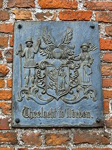
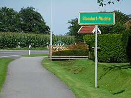
Blandorf-gravity is an East Frisian double village since the Lower Saxony municipal reform from 1972 to spots Hage heard and the districts here Blandorf and gravity forms. The origin of the place is connected with the Norder Theelacht and its history with the noble family of the tho Wicht (later: von Wicht ), from which several well-known personalities emerged.
Surname
The name Wichte is probably derived from the Old High German wiht (= being, demonic being; compare Wichtel , villain ) and in this case would designate a settlement near Wiht or a sanctuary near Wiht . The spelling of Wichte has changed several times over the centuries: Uucht (10th century), Wycht (1552), Wicht (1589) and Wichte (1645).
The interpretation of the place name Blandorf is more difficult. It can be derived from the adjective blank (= shiny), from the nickname Blen-suint or from the family names Plantinga and Plantema . The surname hypothesis is considered "rather unlikely".
Blandorf was first mentioned in a document in 1474. Evidence for the place name Wichte goes back to the 10th century.
Various geographical names in the area or in the vicinity of the joint municipality of Hage refer to Wichte and Blandorf . These include the Wichter Ee , a lake between the islands of Norderney and Baltrum, and the Blandorfer Ehe (north of Landesstraße 6: Blandorfer Tief ), a watercourse used for drainage.
location


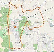
The scattered settlements of Wichte and Blandorf are about two (Wichte) to three kilometers (Blandorf) east of the main town of Hage and are crossed by the L6 state road , which connects Wittmund to the north . Surrounding villages are Hagermarsch in the north, Westerende in the east, Großheide in the south and Berumbur in the southwest. The distance to the North Sea coast is approximately eight kilometers (as the crow flies).
Both localities are located on the northern edge of the East Frisian-Oldenburg Geest . As far as the soil conditions are concerned, Blandorf was founded on a so-called Plaggenesch - "island". Its height is 3.3 m above sea level. To the north and east, a narrow strip of Gleyboden forms the border to the following Knick and Kleimarsch area . In the west - so near Wichte - Podsol and Klei-Podsol meet the area of the double village.
Blandorf-Wichte is connected to local public transport via the VEJ bus routes 361, 362 and 365. They run several times a day between the main train station in the north and the coastal resort of Harlesiel . They touch, among others, Hage, Westerholt and Esens as well as the sewage sites Bensersiel , Neuharlingersiel and Carolinensiel . The nearest train stations are in Norden and Esens.
The railway line of the East Frisian Coast Railway North - Dornum runs through Blandorf-Wichte, but has no boarding options there. The next stops are in Hage and Westerende.
history
Archaeological finds in the area around Blandorf-Wicht prove the presence of fishermen, hunters and gatherers in the area of today's Samtgemeinde Hage in the Middle Stone Age and thus refer to the ninth millennium BC. The first real settlements in this area can be traced back to the early Middle Ages . After 500 AD, people exchanged the uncertainty of the artificial mound in the silting Hilgenried Bay with a safe place to live on the Geest.
Beginnings


The actual beginnings of Blandorf – Wichtes lie at the end of prehistoric times. So-called Uthöfe , also called castles, starting points for later settlements. Eight such outstations had been set up by leading personalities from the three North Drubbel settlements on the beach between Bargebur and Arle . The aim was to use these Uthöfe to make better use of the northern Theellande , which is located in the marshland in front of the Geestrücken . At least two of these outstations, built by Norder Theelachtern, were in the area of the Wichte and Blandorf districts. These were the Wichte house (identical to the Poggenburg, later attested by name ?) And Blandorf Castle . The Osterwichte (= Ost-Wichte ) castle complex, ancestral seat of the von Wicht family , attested to in the 14th century , is now believed to be in the Westerende district east of Blandorf-Wichte .
Around the aforementioned Uthöfe in Wichte and Blandorf, so-called warfmen, who owned the house and land, gathered in the Middle Ages and formed the first settlements with block corridors . Landless hired people were added later, who had to pay a “wage” in the form of natural goods and work obligations for their homes and farmland.
The construction of the St. Ansgari Church in Hague began at the end of the 12th century, but at the latest in the first decades of the 13th century. The necessary funds were provided by the owners of the Uthöfe , including those of the castles in Wichte and Blandorf. In return, they received the common church patronage and thus the right to choose a parish as well as the right to a hereditary burial . While in other regions of East Frisia almost every village settlement had its own sacred building, the leading families of the eight Uthof settlements between Bargebur and Arle built a joint church here, which was to remain the only parish church in the designated area for centuries.
Around the year 1400 the nobleman Imel , who originally lived in Lintel near Norden, settled in Wichte. As Imel t (h) o Wicht (e) he moved to Osterwichte Castle as the chief's seat and became the progenitor of the von Wicht family . Direct successors as lords of the castle were his son Iphtet, his grandson Hayko, his grandson Hicco Iphtena and his great-grandson Hayo Hiccen tho Wichte . The latter held the post of Drosten in the Berum district and successfully defended the Berum castle against the Esensian chief Hero Omken during the Saxon feud . His own castle in Wichte was destroyed in connection with these conflicts. Other descendants of the von Wicht family were active as droste, lawyers, historians and theologians. They worked mainly in East Frisian.
Historic traffic connections
Until the 18th century, the Wichter Ee connected the two villages of Wichte and Blandorf with the North Sea. It was one of the three large flood channels in Hilgenried Bay , which remained in place even after it was dyed. At Nessmersiel it flowed into the Wadden Sea. It was connected to the so-called “Port of Berum” via the Thunschloot , an artificial moat.
In addition, Blandorf-Wichte was connected to the inland via the Heerweg , which was laid out in early historical times and which developed into a trade route in the 16th century and became a postal route in the 17th century. It led from Esens via Westerholt , Arle , Blandorf, Wichte, Hage, Lütetsburg and Bargebur to the north and thus connected the Harlingerland with the Norderland .
School history
Around 1705, the pastors Barthold Meyer and Gerhard Lamberti from Hager initiated the establishment of a so-called secondary school in Wichte. The dimensions of the building have been handed down; According to Hanoverian measures, they were 19 feet and 2 inches in width, 14 feet in length, and 8 feet and 3 inches in height. Between 50 and 60 children of different age groups were taught in this room for many decades. The theologian Bernhard Peter Karl from Osnabrück was appointed the first teacher at the Wichter Schule . Karl, who, like his two colleagues from Hager, was a committed representative of Lutheran Pietism and, among other things, had therefore lost his pastor in Osnabrück, published his unorthodox textbook Catechismus ex Catechismo during his time in Blandorf-Wichte , whereupon the Aurich Consistory initiated impeachment proceedings. The Blandorf-Wichter school community protested against this - initially unsuccessfully. Finally, Karl declared his willingness to submit to the East Frisian church order and in future no longer to disseminate teachings that oppose it. He stayed in Wichte until 1714.
Another teacher who has a special place in the Blandorf-Wichter school history was Foike Tönjes Rosenberg from Hage, who worked as a teacher in Wichte from 1792 to 1851. He had already been appointed to this office at the age of fourteen, although his knowledge of Standard German was extremely poor at the beginning. One of the extra-curricular tasks during his 59-year service also included the fact that, as a servant of the Hage parish, he had to “take the post of waiter at the feasts, occasionally accepting bills”.
The last teacher at the Wichter Schule was Eibe Schulmann. After the Wichter schoolhouse had been demolished in 1857 at the latest due to dilapidation and lack of space, he taught for a short time in Kleinheide , where a new school building had been built. Since 1960 the primary school responsible for Blandorf-Wichte has been in Berumbur . There are secondary schools in Hage and in the north.
Administrative and Political History
In the election for the German National Assembly , the liberal DDP achieved 49.1%, while the SPD achieved 29.1% and the national liberal DVP achieved 20%. The situation changed completely when the right-wing radical DNVP won 68.8% of the vote in the Reichstag election in May 1924 and the DDP became meaningless with 2%. 11.8% voted for the DVP and 17.5% for the NSDAP , which won a two-thirds majority in 1928 with 68.4% and was able to further expand its majority by 1933 with 93.8%.
In the first federal election in 1949, the SPD was the strongest party with 39%, followed by the DP (30.5%), the CDU (8.5%) and the KPD (7.3%). In 1953 there was a shift to the right and the DRP reached 58.2%. The CDU mobilized 21.2% of the voters, the SPD only 12.7%. In the elections from 1957 to 1972, the CDU won an absolute majority. The second strongest force before the SPD was the DRP in 1957 with 19.6%, which in 1969 reached 18.3%. This position was taken by the SPD from 1961 with 21.9%, which improved to 31.9% by 1972.
The formerly independent municipality of Blandorf-Wichte was incorporated into the municipality of Flecken Hage in the course of the Lower Saxony municipal reform of 1972. In the last municipal council election in 2016, the SPD in Blandorf-Wichte achieved 47.4% together with Berum, followed by the CDU (43.4%) and the Greens 9.2%. So the Doppeldorf chose a little more conservatively than the entire municipality of Hage, where the SPD achieved 59.5% and the CDU 31.3%.
coat of arms
|
Blazon : “Blandorf-Wichte had its own coat of arms from 1962 until it was incorporated into Hage in 1972. It was designed by the Münster heraldist Ulf Korn .
The division of the sign “illustrates the growing together of the [former] community from the former small towns of Blandorf and Wichte”. The coat of arms shows a split field in the colors black and gold. In the center are two split lilies, the cut surfaces of which face each other and whose colors are mixed up. Lilies and colors come from the coat of arms of the aforementioned chief family von Wicht. Here three split lines are shown in black, the intersection of which is on the right. The helmet is crowned. A golden lily serves as a crest. " |
|
religion
The vast majority of the Blandorf-Wichter belong to the Evangelical Lutheran Church of Hanover . The twin town has no church building. Since pre-Reformation times it has belonged to the parish of the Hager St. Ansgari Church and here to the parish of Mitte .
Members of the Roman Catholic Church belong to the Coastal Catholic Parish Community and have their nearest place of worship, the St. Wiho Church, in Hage.
Christians who belong to a free church are looked after from the north with a few exceptions. Here you can find Adventists , Baptists , a Free Evangelical Church , Mennonites and Pentecostals as well as other charismatic and evangelical communities. The Methodists have their nearest community center in Neuschoo .
Members of the New Apostolic Church have their house of worship in Hage and Jehovah's Witnesses have their next Kingdom Hall in Lütetsburg .
tourism
The Kurzentrum Hage-Berum is partly located in Wichter area and offers, among other things, an indoor pool with disabled access to the pool. However, the indoor pool remains closed in the summer season. The spa center's heated outdoor pool opens its doors for this. Further offers are a sauna, a medical bath and massage department as well as the possibility of open bath cures.
The Kurpark am See also invites you to relax . It is also partly on important territory.
There are twelve parking spaces for mobile homes very close to the health resort on Wichter Weg . They are available all year round.
Personalities associated with Blandorf-Wichte
- The Lutheran theologian Bernhard Peter Karl (1672–1723) from Osnabrück was a teacher at the secondary school in Blandorf-Wichte at the beginning of the 18th century.
Literature (selection)
- Karl Leiner: Panorama North District . North 1972
- Johann Haddinga , Martin Stromann (photography): Hage health resort. With the villages of Blandorf-Wichte, Berum, Berumbur, Hagermarsch, Halbemond, Lütetsburg . Norden 2002, ISBN 3-928327-55-0
Web links
- Blandorf . (PDF) East Frisian landscape
Individual evidence
- ↑ Compare Hjalmar Falk , Alf Torp : Vocabulary of the Germanic language unit . Part III. Göttingen 1909, p. 382
- ↑ The information relates to Hanswilhelm Haefs: Ostfriesland. Notes on history through reports on the political development of the Frisians, their chiefs, the 6 landscapes [...], place names and local histories . Norderstedt 2013 (Book on Demand), p. 372
- ^ East Frisian landscape: Blandorf, Samtgemeinde Hage, district Aurich (PDF); Retrieved July 11, 2016
- ^ Blandorf, Samtgemeinde Hage, Aurich district . (PDF) East Frisian Landscape; Retrieved July 10, 2016
- ^ Hanswilhelm Haefs: East Frisia. Notes on history through reports on the political development of the Frisians, their chiefs, the 6 landscapes [...], place names and local histories . Books on Demand , Norderstedt 2013, ISBN 978-3-8334-2384-0 . P. 372 - Haefs refers to Arend Remmers: From Aaltukerei to Zwischenmooren: the settlement names between Dollart and Jade . Leer 2004
- ↑ For the geological information see Blandorf (PDF) Ostfriesische Landschaft; Retrieved July 8, 2016
- ↑ Line network Ostfriesland . ( Memento of July 8, 2016 in the Internet Archive ; PDF) VEJ-Bus; Retrieved July 8, 2016
- ^ Johann Haddinga, Martin Strohmann: Hage health resort. With the localities Blandorf-Wichte, Berum, Berumbur, Hagermarsch, Halbemond, Lütetsburg , Norden 2002 (. Edition). P. 22, columns I-III
- ↑ According to Eberhard Rack, these were the following Uthöfe : 1. Lütetsburg, 2. Hilgenbur, 3. Hinkenaburg, 4. Fnuggenburg, 5. Berum Castle, 6. Wichte House, 7. Poggenburg, 8. Blandorf Castle; see Eberhard Rack: Settlement and Settlement of the Altkreis Norden . Aurich 1967, p. 35
- ↑ "Ethel Inge" (nobles); see Gudrun Decker-Schwichow: Big riddle about the origin of the Northern Theelacht solved . Theelacht.de; Retrieved July 10, 2016
- ↑ Eberhard Rack: Settlement and settlement of the old district north . Aurich 1967, p. 84
- ↑ Eberhard Rack considers the Poggenburg to be another Wichter Uthof ; see Eberhard Rack: Settlement and Settlement of the Altkreis Norden . Aurich 1967, p. 35; 48
- ↑ Walter Deeters: from Wicht <Fam.> . (PDF) East Frisian Landscape; Retrieved July 12, 2016
- ↑ According to E. Ippen, this is indicated by the Westerender field name Börg ; see Börg (Westerende) . ( Memento from July 12, 2016 in the web archive archive.today ) Flurnamen-Ostfriesland.de (field names collection of the East Frisian landscape) accessed on August 28, 2019.
- ↑ Eberhard Rack: Settlement and settlement of the old district north . Aurich 1967, p. 48
- ^ Hermann Haiduck: The architecture of the medieval churches in the East Frisian coastal area . Verlag Ostfriesische Landschaft, Aurich 1986, ISBN 3-925365-07-9 , p. 44 f .
- ↑ Monika van Lengen: Hage - Ansgari church and organ . (PDF); accessed on July 13, 2016.
- ↑ Eberhard Rack: Settlement and settlement of the old district north . Aurich 1967, p. 37
- ↑ for example in the Krummhörn and in the Rheiderland
- ↑ Fridrich Arends: Erdbeschreibung des Fürstenthums Ostfriesland and Harlingerland , Emden 1824, p. 420; Text archive - Internet Archive .
- ↑ weights . In: Dettmar Coldewey: Frisia Orientalis. Data on the history of the country between the Ems and Jade . Wilhelmshaven 1967, p. 180.
- ↑ See also Karl Leiner: Panorama district north . Norden 1972, p. 72 f.
- ↑ In addition to the Wichter Ee , there were the Hilgen Riede (today: Breiter Weg ) and the Waterweg (today: Hagermarscher Straße ); see. Johann Haddinga, Martin Strohmann: Hage health resort. With the localities Blandorf-Wichte, Berum, Berumbur, Hagermarsch, Halbemond, Lütetsburg , Norden 2002 (. Edition). P. 28 Col II and III
- ^ Johann Haddinga, Martin Strohmann: Hage health resort. With the localities Blandorf-Wichte, Berum, Berumbur, Hagermarsch, Halbemond, Lütetsburg , Norden 2002 (. Edition). P. 29 column I
- ↑ On the pastors Meyer and Lamberti, representatives of Lutheran Pietism and promoter of Spener pedagogy in East Friesland see Menno Smid: Ostfriesische Kirchengeschichte . Volume VI in the series Ostfriesland in the protection of the dike . Pewsum 1974. pp. 364ff
- ↑ 1 foot = 292.1mm; 1 inch 24.3mm
- ↑ Werner H. Schönherr: Between March and Moor. History and stories from the old Berumbur from the beginning to the municipal reorganization in 1972 . North 2012. ISBN 978-3-939870-69-2 . P. 57
- ↑ Other spelling: Bernhard Peter Carl
- ↑ Menno Smid: East Frisian Church History . Volume VI in the series Ostfriesland in the protection of the dike . Pewsum 1974. p. 366
- ↑ Rejection of infant baptism , symbolic meaning of the sacraments, various Donatist teachings; see Menno Smid: Ostfriesische Kirchengeschichte . Volume VI in the series Ostfriesland in the protection of the dike . Pewsum 1974. p. 366
- ↑ See Werner H. Schönherr: Between Marsch and Moor. History and stories from the old Berumbur from the beginning to the municipal reorganization in 1972 . Norden 2012. pp. 57–61 ( From school desk to chair )
- ↑ Quoted from Werner H. Schönherr: Between Marsch and Moor. History and stories from the old Berumbur from the beginning to the municipal reorganization in 1972 . North 2012. p. 61
- ↑ Werner H. Schönherr: Between March and Moor. History and stories from the old Berumbur from the beginning to the municipal reorganization in 1972 . North 2012. p. 62
- ↑ Our school . gs-berumbur.de; accessed on August 4, 2016
- ↑ a b Blandorf, joint municipality Hage, district Aurich . (PDF) East Frisian Landscape, p. 3; accessed on February 18, 2017.
- ^ Local council election Hage electoral district result 004: Hage-Berum and Blandorf-Wichte. accessed on February 18, 2017.
- ↑ NLA AU Rep. 245 No. 58 (Blandorf-Wichte) . Archive Information System Lower Saxony; Retrieved July 12, 2016
- ↑ Quoted from Karl Leiner: Panorama district north . Norden 1972. p. 69
- ^ Gudrun Anne Dekker: Ubbo Emmius. Life, the environment, the estate and the present . Norderstedt 2010 (Book on Demand). P. 186, note 526 ( books.google.de ). In Siebmacher's coat of arms it says: “Wicht: Chief family from Wicht near Berum, which already went with Imel v. W. beginning of the 14th saec. appears. Coat of arms (plate 264): In black 3 (2, 1) right halves of split golden lilies. Helmet: whole golden lily between two silver ostrich feathers. ”( J. Siebmacher's large and general book of arms . Volume 1, edition 3. p. 209)
- ↑ In 1972 it was 98% of the population; see Karl Leiner: Panorama North District . Norden 1972. p. 71
- ↑ About us. Districts . Ansgari Church Hage; Retrieved July 8, 2016
- ↑ Hage . Sankt Ludgerus north; Retrieved July 8, 2016
- ^ Hage spa center . ( Memento from October 4, 2016 in the Internet Archive ) Störtebekerland.de; accessed on September 18, 2018
- ^ Blandorf-Wichte . Mobilisten.de; Retrieved July 8, 2016
- ^ Martin Tielke: Karl, Bernhard Peter (PDF) East Frisian landscape; Retrieved July 8, 2016


