
Nüttermoor
|
Nüttermoor
City of Leer (East Frisia)
Coordinates: 53 ° 15 ′ 37 ″ N , 7 ° 26 ′ 7 ″ E
|
|
|---|---|
| Height : | 1.6 m above sea level NN |
| Area : | 13.37 km² |
| Residents : | 265 (2017) |
| Population density : | 20 inhabitants / km² |
| Incorporation : | 1st January 1973 |
| Postal code : | 26789 |
| Area code : | 0491 |
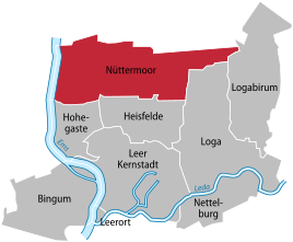  Location of Nüttermoor in the city of Leer
|
|
 Aerial view of Nüttermoor from the northeast
|
|
Nüttermoor is a district of Leer (East Friesland) . The district is located in the north of the city and is now significantly larger than the original village of Nüttermoor.
Location, economy and club life
Nüttermoor stretches from the Emsdeich far to the east of the city, to Logabirum . The following residential areas belong to the district: Eisinghausen , Klostermühle , Neuhaus, Nüttermoorersiel, Thedingaer Vorwerk, Thedinga Monastery , Mooräcker and Wüstenei.
In the north of the district on the A 31 are the regional airfield Leer-Papenburg and the 160 meter high telecommunications tower Leer-Nüttermoor ( type tower ). In addition, there are large commercial and industrial areas in Nüttermoor, which use the proximity to two motorway entrances. In the industrial area ( Leer-Nord ) is a natural gas - cavern storage of EWE gas storage GmbH. The place can be reached from the Ems via a pier. Nüttermoor is also the location of one of the two large shopping centers in the city.
There is a sports club in the district.
history
Originally Nüttermoor is an old village north of the settlement of Leer, on a ridge on the edge of the moor. Hence the village was called Uttermoor in the Middle Ages . As early as 1283, the Thedinga monastery was founded not far from Nüttermoors , and the local church is said to have been a branch of the monastery. The Reformed Church dates from the beginning of the 13th century and was built as a hall church on a terp . On January 1, 1973 Nüttermoor was finally incorporated into the city of Leer.
Web links
- Entry about Nüttermoor in the genealogy forum with pictures
Individual evidence
- ^ Federal Statistical Office (ed.): Historical municipality directory for the Federal Republic of Germany. Name, border and key number changes in municipalities, counties and administrative districts from May 27, 1970 to December 31, 1982 . W. Kohlhammer GmbH, Stuttgart / Mainz 1983, ISBN 3-17-003263-1 , p. 262 .
Core city | Bingum | Heisfelde | Hohegaste | Empty location | Loga | Logabirum | Nettelburg | Nüttermoor