
Klostermühle (Thedinga)
|
Monastery mill
City of Leer (East Frisia)
Coordinates: 53 ° 16 ′ 17 ″ N , 7 ° 27 ′ 30 ″ E
|
|
|---|---|
| Height : | 1 m |
| Incorporation : | 1972 |
| Postal code : | 26789 |
| Area code : | 0491 |
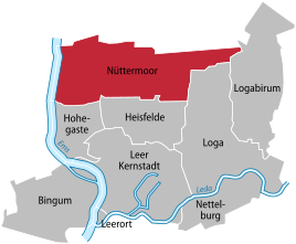  Location of Nüttermoor in the city of Leer
|
|
Klostermühle is a residential area with a few houses on the extreme northern edge of the city of Leer . It is located on the Leer - Emden railway line , the B70 , at the entrance to the Leer-Papenburg airport and belongs to the Nüttermoor district of the city of Leer . This is where the Nüttermoor pressure booster system is located, which helps ensure the water supply in the Leer district.
history
The settlement was first recorded in 1823 as "Thedingaer Mühle". The name "Klostermühle", which is valid today, has been in use since 1871. A mill may have been there since the Middle Ages. This once belonged to the Benedectine monastery " Thedinga ". The predecessor of today's building may have been built in the 15th century, as mills were also being built in other places in East Frisia at the time. The preserved lower part of the last mill, the stone octagon, comes from a Dutch gallery built in 1881 . Originally it was probably a post mill , a type of mill that has been known in Germany since the 12th century. In 1743 a new rye mill and peldemühle were built on the same site . It will have been an Erdholländermühle , still without a gallery. The mill from 1881 burned down completely on the night of March 10th to 11th, 1947. A short circuit was suspected to be the cause of the fire. The mighty windmill was not rebuilt afterwards. Only the converted octagonal mill stump up to the gallery remained and was covered. A restaurant was operated in this massive mill substructure for decades, while the rest of the former mill courtyard building served as a carpentry shop. Today the mill stump is used as a residential building.
Web links
- Ortschronisten der Ostfriesischen Landschaft : Nüttermoor, Stadt Leer, District Leer (PDF; 40 kB), accessed on December 17, 2012
- Water supply association Moormerland-Uplengen-Hesel-Jümme: picture and text on the pressure booster system , viewed on December 14, 2014