Nendorp
|
Nendorp
Jemgum parish
|
|
|---|---|
| Coordinates: 53 ° 18 ′ 34 " N , 7 ° 18 ′ 51" E | |
| Height : | 1 (0.9-1.8) m above sea level NHN |
| Area : | 4.22 km² |
| Residents : | 126 (Jun 30, 2015) |
| Population density : | 30 inhabitants / km² |
| Incorporation : | 1st January 1973 |
| Postal code : | 26844 |
| Area code : | 04902 |
|
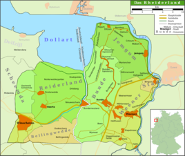
Map of the Rheiderland
|
|
|
The Nendorper Church
|
|
Nendorp is a village in the Lower Saxony municipality of Jemgum in the East Frisian Rheiderland . The village has a size of 4.2 square kilometers and 126 inhabitants.
location
Nendorp is located near the Ems on Landstrasse 15 between Jemgum and Ditzum and is heavily agricultural . The Nendorper dyke foreland is a nature reserve that covers 117 hectares.
history
The place name Nendorp means something like "New Village" and is in contrast to the nearby "Old Village" Oldendorp . Nendorp was first mentioned around 1500. On January 1, 1973, Nendorp was incorporated into the municipality of Jemgum.
The place became known through the Ems barrier , on the south side of which it is located. Another distinctive building is the Evangelical Reformed Nendorper Church , which was built in 1820, but still has significantly older parts of the building.
literature
- Klaas-Dieter Voss (ed.): The families of the parish Nendorp (1698-1911) . Upstalsboom-Gesellschaft, Aurich 2011, ISBN 978-3-934508-61-3 (Ostfriesland Ortssippenbücher, vol. 88; German Ortssippenbücher, vol. 590).
Individual evidence
- ↑ Jemgum.de: structural data , accessed on April 15, 2018.
- ^ Federal Statistical Office (ed.): Historical municipality directory for the Federal Republic of Germany. Name, border and key number changes in municipalities, counties and administrative districts from May 27, 1970 to December 31, 1982 . W. Kohlhammer GmbH, Stuttgart and Mainz 1983, ISBN 3-17-003263-1 , p. 263 .


