Pogum
|
Pogum
Jemgum parish
|
|
|---|---|
| Coordinates: 53 ° 19 ′ 6 ″ N , 7 ° 15 ′ 31 ″ E | |
| Height : | 1 m above sea level NHN |
| Area : | 4.75 km² |
| Residents : | 205 (Jun 30, 2015) |
| Population density : | 43 inhabitants / km² |
| Incorporation : | 1st January 1973 |
| Postal code : | 26844 |
| Area code : | 04902 |
|
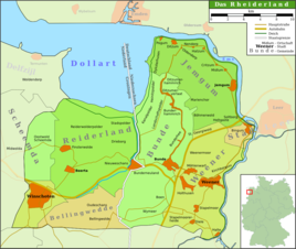
Map of the Rheiderland
|
|
|
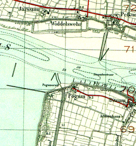
Card with Pogum from 1933
|
|
Pogum ( Low German Poom ) in Rheiderland is a village in the municipality of Jemgum in the district of Leer in Lower Saxony in East Frisia .
location
The village opposite the seaport town of Emden is located directly in the transition area from the Ems to the Dollart and still has a small muhde port. The area is 4.75 hectares. It is currently inhabited by 205 people (as of 2015). Pogum includes the actual village at the mouth of the Ems and the Dyksterhusen district to the south-west .
history
The place is mentioned in documents as early as the 14th century: in 1367 it is called "Urapawengum". Excavation documents, which were secured during an emergency excavation in 1964, testify to a settlement in the first century before to the fifth century after the birth of Christ and a new land grab in the seventh century.
The Pogumer Church was built in 1776. There are two trapezoidal tombstones from the 11th century, which are probably the oldest in East Frisia. The organ was designed by Johann Adam Berner (1758–1759) and has six registers . The Pogum congregation is one of the few Lutheran congregations in the otherwise strongly Reformed Rheiderland.
During the storm surge of 1962 , houses that were standing directly on the sea dike at the time were hit by sliding earth. In contrast to Völlen, Pogum narrowly escaped a dike breach, which would have led to the partial flooding of the Rheiderland. In 1971 the sewer from 1877 was replaced and a new pumping station was inaugurated. By strengthening the dike, the northern part of Dyksterhusen was abandoned and a new settlement was created for the residents to the south.
The place Pogum belongs since January 1, 1973 to the municipality Jemgum .
In 1998 the village of Pogum was included in the village renewal program of the state of Lower Saxony . Pogum is popularly known as the “Endje van de Welt” (Eng. “End of the World” ) because the road used to end here, at the northernmost point of the Rheiderland, and you stood in front of the Dollart, the mouth of the Ems.
Events
Every two years (e.g. again in 2020) the village festival takes place in Pogum. In the meantime, a bathtub race is being held on the Sieltief as part of the village festival. The bathtubs are so artistically decorated and built around that you can usually no longer see the underlying tub. In a small ceremony, prizes will be awarded for the most beautiful and the fastest bathtub. And there is also a prize for the most beautiful "downfall".
An annual Kreierrennen took place under the motto "Up de Spör van de Dullartfiskers" and was of national importance. Traditionally, the Kreier, a kind of sledge, were used in fish traps in the Dollart.
The village association Pogum-Dyksterhusen eV looks after the Dörphuus located on the Sieltief and organizes the numerous activities spread over the year.
Individual evidence
- ↑ a b Ortschronisten der Ostfriesischen Landschaft : Pogum , accessed on July 10, 2018.
- ↑ Joost Kirchhoff: Storm surge 1962. The disaster night on the Ems and Dollart. Process - Findings - Conclusions. Risius, Weener 1992.
- ^ Federal Statistical Office (ed.): Historical municipality directory for the Federal Republic of Germany. Name, border and key number changes in municipalities, counties and administrative districts from May 27, 1970 to December 31, 1982 . W. Kohlhammer, Stuttgart / Mainz 1983, ISBN 3-17-003263-1 , p. 263 .
- ↑ Village Festival & Bathtub Race , accessed on February 20, 2019.
- ↑ The Wattschlitten von Pilsum and Pogum , accessed on February 20, 2019.
- ^ Website of the village association , accessed on February 20, 2019.


