Gust
|
Gust
municipality Bunde
|
|
|---|---|
| Coordinates: 53 ° 8 ′ 43 " N , 7 ° 15 ′ 58" E | |
| Height : | 0.2 m above sea level NN |
| Area : | 8.79 km² |
| Residents : | 461 (2005) |
| Population density : | 52 inhabitants / km² |
| Incorporation : | November 1, 2001 |
| Postal code : | 26831 |
| Area code : | 04903 |
|
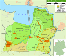
Map of the Rheiderland
|
|
|
Former dairy - today the church of the Bible community
|
|
The row village Boen is located in the East Frisian Rheiderland between the federal motorway 31 and the German-Dutch border in a moor area. Around 460 people live in the village on an area of around 8.79 square kilometers. Boen is a village in the municipality of Bunde in the district of Leer and has a local mayor.
history
The name is first attested as Bonewerda in 1475 . Later spellings are Baen (1585), Bohne (1645) and Bohlen (1719). The meaning of the name is unclear.
Until 1467 Boen belonged to the Propstei Hatzum in the diocese of Münster and had its own church. It became a victim of the Dollart around 1500 , which reached its greatest extent with the Second Cosmas and Damian Flood (1509). The inhabitants fled the old row of settlements, which were haunted by the water, and founded a new village on the safe moor. The parish was parish near Bunde.
In the first half of the 16th century, the "Oll Diek" was therefore built as a defensive dike between Bunde and Wymeer . It was continued in the Schwelchdeich near Dünebroeck , which may already have been used to reclaim land. In the 17th century, the land acquisition led to lengthy disputes with the East Frisian counts over the lease. Another ongoing conflict developed from 1699 with the Dutch border residents, who suffered from increased drainage. This dispute could only be settled in 1824 with the "Meppen Treaty". Due to severe flooding after the Westerwolder Aa dyke breached, armed clashes broke out with the Dutch residents of Bellingwolde in 1833/34 .
Between 1868 and 1910 over 30 residents of Boens emigrated overseas.
In 1973 Boen joined the joint congregation Bunde and has been part of the new unified congregation since November 1, 2001. Since then Boen has been part of Bunde.
Economy and Infrastructure
In the Middle Ages, fishing and trade were the main livelihoods. Agriculture was predominant from the 16th century onwards. Boen is still dominated by agriculture today. Gulf houses determine the appearance of the place, some of which are listed. However, the number of farms is decreasing: while there were 51 farms in 1961, the number fell to 30 in 2005. Crafts are hard to find and focus on bundles.
A separate school as a branch to Bunde is documented for the first time in 1766. The Boenster elementary school was closed in 1970, served the Evangelical Bible Congregation Boen Congregation as a community room for a few years and became a village community center in 1990.
The Wymeer-Boen volunteer fire brigade was founded in 1919 and has been providing fire protection and general help, especially at local level, ever since. The Wymeer-Boen sports club dates back to 1956.
Religions
After the church was destroyed around 1500, there was no new church building in Boen. Since then the churchgoers have visited the parishes in Wymeer or Bunde.
From a Bible discussion group (1967), the Free Evangelical Bible Congregation of Boen emerged in 1989 , which today has found its community center in the former dairy.
literature
- Wymeer Boen. Life between the moor and the sea . Risius, Weener 2005.
- Harm Wiemann: From days gone by. Chronicle of the combined community of Bunde . Self-published, Bunde 1983.
Web links
- Paul Weßels (local chronicle of the East Frisian landscape ): Boen (PDF; 413 kB)
Individual evidence
- ↑ a b c d Paul Weßels (local chronicle of the East Frisian landscape ): Boen (PDF file; 33 kB) (as of August 20, 2012).
- ^ Harm Wiemann: From bygone days. Chronicle of the combined community of Bunde . Selbstverlag, Bunde 1983, pp. 21-23.
- ↑ StBA: Changes in the municipalities in Germany, see 2001


