Dollard (Bundle)
|
Dollard
municipality Bunde
|
|
|---|---|
| Coordinates: 53 ° 15 ′ 32 ″ N , 7 ° 16 ′ 1 ″ E | |
| Height : | -2.5-3.5 m above sea level NN |
| Residents : | 1258 (Nov. 5, 2004) |
| Incorporation : | November 1, 2001 |
| Postal code : | 26831 |
| Area code : | 04959 |
|
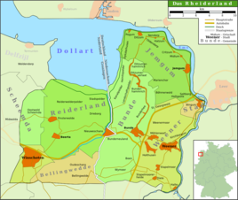
Location of Dollart in the Rheiderland
|
|
Dollart is a village in the municipality of Bunde , which got its name from Dollart , the adjacent bay of the same name. The place in the East Frisian Rheiderland comprises the villages of Ditzumerhammrich , Ditzumerverlaat , Heinitzpolder , Kanalpolder , Landschaftspolder and Bunderhammrich , which were built as dike settlements . There is no historical place called Dollart.
population
The village of Dollart in the municipality of Bunde has 1285 inhabitants (as of November 5, 2004), who are spread over various small towns.
geography
The place is located east of the bay and is protected from flooding by dikes . The entire place was created through land reclamation and lies on fertile marshland . The district borders the municipality of Jemgum in the north and northeast, the Bunderhee district in the southeast and Bunde in the south.
Several sewer depths serve as drainage channels for the low-lying land. The area around the Wynhamster Kolk is located 2.5 m below the sea level below sea level and is one of the deepest-lying places Germany.
history
The area of today's bay was densely populated in the Middle Ages. With the expansion of the Dollart in the 14th to 16th centuries, numerous parishes and villages went under. The village of Dollart owes its emergence to the so-called growth of new areas from the dyke foreland through land reclamation and dyke construction . After the Dollart withdrew, the dyke construction began around 1600. Bunderhammrich was diked in 1707, landscape polder in 1752, Heinitz polder in 1773 and 1794 and canal polder from 1874 to 1877.
From 1807, under French rule, the area was part of the Dutch Ems-Occidental ("Wester Eems") department. In 1813 the first "Dollart community" was created, into which the villages of Landschaftspolder, Heinitzpolder, Bunderhammrich, Böhmerwold and St. Georgiwold were incorporated. After the fall of Napoleon Bonaparte , the area was added to the Kingdom of Hanover. Ditzumerhammrich and Ditzumerverlaat belonged to the political municipality of Ditzum until 1852. In 1885 East Frisia became Prussian. After the Second World War , there was a relatively high influx of refugees, which can be attributed to the high-yield polder areas. In 1966, the first joint community in the district of Leer was founded, the joint community of Dollart, to which the Landschaftspolder was added in 1969. As early as January 1, 1973, Bunderhammrich, Ditzumerhammrich, Heinitzpolder and Landschaftspolder were combined to form a municipality of Dollart and incorporated into the joint municipality of Bunde. When this joint congregation was also dissolved on November 1, 2001, the Dollart congregation lost its independence and became a locality of the Bunde unified congregation with its own mayor.
Religions
The vast majority of Dollart's residents belong to the Evangelical Reformed Church . In Ditzumerverlaat a Reformed parish was established in 1887 and a church of its own in 1896 to save the fishermen and boatmen the trip to Ditzum. After the dike in the Landschaftspolder in 1752, the Landschaftspolder Church was built in 1768 . The Baptist congregation , founded in 1865, has had a chapel in Ditzumerverlaat since 1899 .
Culture and sights
North of Ditzumerverlaat is the Wynhamster Kolk with a small wind-water mill from 1804. It was used to drain the surrounding area, which is 2.51 m below sea level.
As elsewhere in East Friesland, the churches were built as brick churches. The polder church in Landschaftspolder was built in 1768 after Frederick the Great had given permission. The reformed church in Ditzumerverlaat was built in 1896 in the neo-Gothic style.
In winter, an artificial ice rink can be used for ice skating in Ditzumerverlaat . In strong winters, the numerous drainage depths are also suitable for this purpose. The Turn- und Sportverein (TuS) Ditzumerverlaat organizes the sporting activities, especially football . A cross-border bike course is the International Dollard Route , which extends over 200 km through the districts of Leer and Emsland and the province of Groningen . A local association coordinates tourism and cultural activities.
In 1997 the "Dollart Nature and Culture Park" was opened in a Bunder Gulfhaus . In addition to a museum about the nature, economy and history of the Dollart, it includes the possibility of cycling to the bay and using the signs to find out about the construction of the dyke and land reclamation.
literature
- Harm Wiemann u. a .: From bygone days: Chronicle of the Bunde Samtgemeinde . Ed. Samtgemeinde Bunde. Self-published, Bunde 1983.
- Johann Schulte: Verlaat - (not) a chronicle of the former Dollart community . Festschrift for the 250th anniversary of Ditzumer-Verlaat. Artline, Bunde 2003.
Web links
- Homepage of the municipality of Bunde
- Local chronicle of the East Frisian landscape : Ditzumerhammrich (PDF file; 37.7 kB)
- Local chronicles of the East Frisian landscape: Heinitzpolder (PDF file; 22.4 kB)
- Hartmut Rebuschat (local chronicle of the East Frisian landscape): Landscape folder ( PDF file; 42.3 kB)
Individual evidence
- ^ Ortschronisten der Ostfriesische Landschaft: Heinitzpolder (PDF file; 22.4 kB) (as of June 25, 2011).
- ^ Federal Statistical Office (ed.): Historical municipality directory for the Federal Republic of Germany. Name, border and key number changes in municipalities, counties and administrative districts from May 27, 1970 to December 31, 1982 . W. Kohlhammer GmbH, Stuttgart and Mainz 1983, ISBN 3-17-003263-1 , p. 263 .
- ↑ StBA: Changes in the municipalities in Germany, see 2001
- ^ Homepage of the Evangelical Free Church Community: History and Stories (as of September 5, 2010).

