Heinitzpolder
|
Heinitzpolder
municipality Bunde
Coordinates: 53 ° 15 ′ 37 " N , 7 ° 14 ′ 56" E
|
|
|---|---|
| Height : | 1–2.5 m above sea level NN |
| Area : | 30.86 km² |
| Residents : | 364 (1961) |
| Population density : | 12 inhabitants / km² |
| Incorporation : | 1st January 1973 |
| Incorporated into: | Dollard |
| Postal code : | 26831 |
| Area code : | 04959 |
|
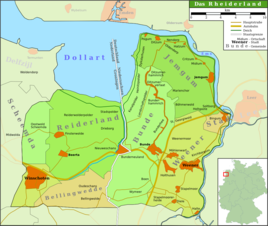
Location of Dollart in the Rheiderland
|
|
The dyke row settlement Heinitzpolder belongs to the Dollart district in the municipality of Bunde in the East Frisian Rheiderland . A small part of Heinitzpolder is located in the northern municipality of Jemgum .
geography
The place lies east of the Dollart and is only separated from the bay by the narrow strip of the local area of Kanalpolder . Landscape polder borders in the southwest . The area is protected from flooding by dikes . The entire place was created through land reclamation and lies on fertile marshland . The settlement is located on a dike . A sewer serves as a drainage channel for the low-lying land.
history
The place was created by so-called growth of a new area from the dyke foreland by means of land reclamation and dyke construction. In 1773, some entrepreneurs leased the dike foreland from Landschaftspolder and built a dike, which, however, could not withstand the storm surges. A second group of interested parties made a second attempt from 1794 to 1796, which this time was successful. Heinitzpolder was the first place in Rheiderland a navigable channel through a Siel granted access to the Dollard. In 1796 the name "Heinitz Polder" is attested for the first time. He owes it to the Prussian Minister of State Friedrich Anton von Heynitz (1725–1802).
Under French rule, the area was part of the Dutch department of Ems-Occidental ("Wester Eems") from 1807 . In 1813 the first "Dollart community" was created, into which the villages of Landschaftspolder, Heinitzpolder, Bunderhammrich , Böhmerwold and St. Georgiwold were incorporated. After the fall of Napoleon , the area was added to the Kingdom of Hanover. The February flood of 1825 led to a dike breach in Heinitzpolder and the land was flooded. It was not until 1874 to 1877 that the Heinitzpolder canal polder grew. In 1885 East Frisia became Prussian. After the Second World War, there was a relatively high influx of refugees, which can be attributed to the high-yield polder areas.
In 1966 the joint municipality of Dollart, named after the nearby bay , was founded, which consisted of the villages of Ditzumerhammrich, Ditzumerverlaat, Bunderhammrich, Heinitzpolder and Kanalpolder , but in 1973 it lost its independence and was incorporated into the joint municipality of Bunde. Heinitzpolder was incorporated into the new Dollart community on January 1, 1973. Since November 1, 2001, the place has belonged to the Bunde community.
Religions
Heinitzpolder has belonged to the Landschaftspolder parish since 1821 and to Ditzumerverlaat since 1887 . A new Reformed parish was established there, which was given its own church in 1896.
literature
- Harm Wiemann u. a .: From bygone days: Chronicle of the Bunde Samtgemeinde . Ed. Samtgemeinde Bunde. Self-published, Bunde 1983.
- Johann Schulte: Verlaat - (not) a chronicle of the former Dollart community . Festschrift for the 250th anniversary of Ditzumer-Verlaat. Artline, Bunde 2003.
Web links
- Homepage of the municipality of Bunde
- Local chronicles of the East Frisian landscape : Heinitzpolder (PDF file; 22 kB)
Individual evidence
- ^ Ortschronisten der Ostfriesische Landschaft: Heinitzpolder (PDF file; 22 kB) (as of September 6, 2010).
- ^ Federal Statistical Office (ed.): Historical municipality directory for the Federal Republic of Germany. Name, border and key number changes in municipalities, counties and administrative districts from May 27, 1970 to December 31, 1982 . W. Kohlhammer GmbH, Stuttgart and Mainz 1983, ISBN 3-17-003263-1 , p. 263 .
- ↑ StBA: Changes in the municipalities in Germany, see 2001
