Bunderhammrich
|
Bunderhammrich
municipality Bunde
Coordinates: 53 ° 14 ′ 45 ″ N , 7 ° 16 ′ 41 ″ E
|
|
|---|---|
| Height : | 2.4 m above sea level NN |
| Area : | 8.2 km² |
| Residents : | 653 (1970) |
| Population density : | 80 inhabitants / km² |
| Incorporation : | 1st January 1973 |
| Incorporated into: | Dollard |
| Postal code : | 26831 |
| Area code : | 04959 |
|
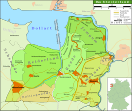
Map of the Rheiderland
|
|
Bunderhammrich is a village in East Frisia . Politically it belongs to the municipality of Bunde . Bunderhammrich is located in the Rheiderland , one of the four historical landscapes in the district of Leer.
location
Bunderhammrich is a row settlement . It was laid out on a dike that was built to protect the Marienchor . The place is at an average height of 2.4 meters above sea level . Due to its location on the former dike, east of the village of Altmarsch is located , while to the west is the area of landscape polder , which was only reclaimed from the Dollart in 1751 .
history
The earliest evidence of the presence of people in Bunderhammrich are pottery shards, which are dated to the Roman Empire and the Middle Ages . The area of today's Dollart and the areas reclaimed from the sea is old settlement land that was still densely populated in the late Middle Ages. The bay is similar to the Jade Bay , the result of marine burglaries in the late Middle Ages, the original moorland have largely been dispelled. With the creation of the Dollard and the collapse of the Emsbank, at least 20 parishes and 10 to 15 other villages and three monasteries perished. The eastern dollar bosom formed in the first half of the 15th century. As early as 1454 an emergency dike was built from the solid bank of the Ems across the moor to the high Geest near Finsterwolde, which was supposed to protect the Oldambt . The western bosom, on whose territory Bunderhammrich lies, was probably not created until the 1460s. Large parts of this area were still largely untouched by the sea when the Second Cosmas and Damian Floods in 1509 and then the Antoni Flood in 1511 penetrated far into the interior. In the Bunderhammrich area, a dike protecting the Marienchor was built as early as 1509 . After the coastline was shifted by further dikes, the settlement of the now no longer needed dike in Bunderhammrich began. The wide open spaces around the place were either in supervisor trek right or leasehold awarded. In addition, many farm workers settled in the place. In 1719 there were 24 herds and 27 farm workers' households. Until the 19th century, the inhabitants were politically represented by a bulk master who was elected by the local voters.
After the battle of Jena and Auerstedt in 1806, East Friesland was incorporated into the Kingdom of Holland and thus into the French sphere of influence. This annexation was recognized by Prussia in the Peace of Tilsit in 1807 . Under the rule of the Netherlands in 1807 an administrative reorganization took place and Bunderhammrich was affiliated to the Commune Landschapspolder , which also included Landschaftspolder, Heinitzpolder , Böhmerwold and St. Georgiwold . This commune thus formed a forerunner of the later Dollart community. After Napoleon's defeat, the old administrative structures were restored and the individual communities of the Commune Landschapspolder became independent again. Under the rule of Hanover , Bunderhammrich was part of the Weener office; after the annexation of the Kingdom of Hanover by Prussia in 1866, it became a municipality in the Weener district , which was opened in the Leer district in 1932 .
On January 1, 1973 Bunderhammrich was incorporated into the new community of Dollart. This was assigned to the municipality of Bunde on November 1, 2011.
Development of the place name
The place is mentioned in 1573 as nye Hammerick , 1645 as Niehamrich , 1787 as the new Hamrich . The current name Bunderhammrich has been used since 1818 .
Population development
Due to the remote location of the place and the loss of importance for the farm workers, the population development stagnated in the 19th and 20th centuries. After the Second World War , the proportion of refugees and displaced persons from the eastern regions of the German Reich in the local population was 20.5 percent, only slightly above the East Frisian average. By 1950 their share decreased to 15.1 percent.
| year | population |
|---|---|
| 1848 | 632 |
| 1871 | 647 |
| 1885 | 653 |
| 1905 | 722 |
| 1925 | 718 |
| 1933 | 694 |
| 1939 | 614 |
| 1946 | 510 |
| 1950 | 687 |
| 1956 | 590 |
| 1961 | 639 |
| 1970 | 653 |
Individual evidence
- ↑ a b c d e f g h Working group of the local chronicles of the East Frisian landscape : Bunderhammrich, municipality of Bunde, district of Leer (PDF; 550 kB), accessed on December 15, 2011.
- ^ Walter Deeters: Small State and Province. General history of modern times , in Karl-Ernst Behre / Hajo van Lengen: Ostfriesland. History and shape of a cultural landscape , Ostfriesische Landschaft, Aurich 1995, ISBN 3-925365-85-0 , p. 167.
- ↑ a b c Federal Statistical Office (ed.): Historical municipality directory for the Federal Republic of Germany. Name, border and key number changes in municipalities, counties and administrative districts from May 27, 1970 to December 31, 1982 . W. Kohlhammer GmbH, Stuttgart and Mainz 1983, ISBN 3-17-003263-1 , p. 263 .
- ↑ StBA: Changes in the municipalities in Germany, see 2001
