St. Georgiwold
|
St. Georgiwold
City of Weener
|
|
|---|---|
| Coordinates: 53 ° 12 ′ 59 ″ N , 7 ° 19 ′ 18 ″ E | |
| Height : | -0.8-0.7 m above sea level NN |
| Area : | 6.75 km² |
| Residents : | 61 (December 31, 2017) |
| Population density : | 9 inhabitants / km² |
| Incorporation : | 1st January 1973 |
| Postal code : | 26826 |
| Area code : | 04953 |
|
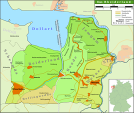
Map of the Rheiderland
|
|
St. Georgiwold ( East Frisian Platt Swartwold ) is the northernmost district of the city of Weener in the East Frisian Rheiderland . The place had 61 inhabitants in 2017.
Location and area
St. Georgiwold is a row settlement. It lies between Weener and Bunderhee in were dug bog area at an altitude 0 and between 0.7 m above sea level . Overall, the place covers an area of 6.75 square kilometers.
history
The Moor area northwest of Weener, in which the village was built later, in the lifting registers of Werden Abbey ninth to the 10th century as uppan Uualda referred. The Middelweg , an old military route that once led from Münster to the Palmar Monastery , ran through the moor .
At the latest in the 13th and 14th centuries, the reclamation and settlement by extension began here . The plots created in this way were between 35 and 100 meters wide and over time reached a length of up to four kilometers.
From this time, two house squares of the 13th / 14th century east of today's village center were built. Century and who discovered the floor plan of a church from the 15th century. This settlement had major drainage problems, so it was relocated to its current location in several steps. In the Middle Ages the village belonged to the Rheiderland. St. Georgiwold was mentioned for the first time in 1450 in a report to the Bishop of Munster, who was supposed to describe church life in East Friesland. At that time, 20 to 30 church villages were under water in the Rheiderland as a result of storm surges. Most were given up. Only the villages Wymeer, Boen, Bunderhammrich, Ditzumerhammrich, St. Georgiwold, Böhmerwold, Blijham and Beerta were relocated or repopulated.
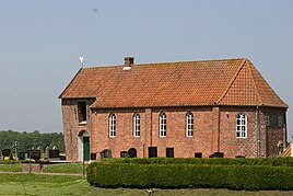
In 1681 the wooden church in Sündt-Jürgenswoldt , as the place was called at that time, was dilapidated. Eight years later the construction of a stone church began. This church was also built to the west of the old location. It was consecrated to Saint George . Because the building sagged from 1810 due to the lack of foundations, the church was rebuilt in 1960 on the old floor plan. Since the Reformation, the place has been dominated by Protestant reforms. The school building with the teacher's apartment was replaced by a new building in 1803, and the single-class elementary school was closed on April 16, 1935. Sankt Georgiwold had major problems with drainage well into the 20th century. This situation did not improve until between 1896 and 1960 the sewage depth and pumping station were newly built. At the time of National Socialism, the village was considered a stronghold of the NSDAP in the Rheiderland. In the 1932 presidential election, for example, Hitler received 90.1% of the vote.
After the Second World War, the place took on a particularly large number of displaced persons , who at times made up 45% of the population. This is probably due to the fact that St. Georgiwold was viewed as being very productive in agriculture. In the course of the municipal reform, the previously independent village was incorporated on January 1, 1973. It is the smallest district there. Economically it is still strongly influenced by agriculture today.
Population development
| year | Residents |
|---|---|
| 1823 | 140 |
| 1848 | 167 |
| 1871 | 144 |
| 1885 | 169 |
| 1905 | 134 |
| 1925 | 128 |
| 1933 | 121 |
| 1946 | 170 |
| 1961 | 113 |
| 1970 | 98 |
| 2009 | 70 |
| 2017 | 61 |
literature
- Local history working group e. V. Weenermoor - Möhlenwarf - Sankt Georgiwold - Beschotenweg (Ed.): 10 years chronicle of the local history working group e. V. Weenermoor - Möhlenwarf - Sankt Georgiwold - Beschotenweg , self-published, Weener 2005.
- Johannes Ey, ' Middeleeuwse opstreknederzettingen in het oostelijk Dollardrandgebied ', in: Karel Essink (ed.), Stormvloed 1509. Geschiedenis van de Dollard , Groningen: Stichting Verdronken Geschiedenis 2013, pp. 61–75 (Dutch).
- Hinrich Geerdes, Egon Smid: St. Georgiwold. A village with many names. H. Risius, Weener 2014.
Individual evidence
- ↑ a b Heimatkundlicher Arbeitskreis eV, Weenermoor - Möhlenwarf - St. Georgiwold - Beschotenweg: The localities - Sankt Georgiwold , viewed on February 2, 2010.
- ↑ a b c d e local chronicles of the East Frisian landscape: Sankt Georgiwold, city of Weener, district of Leer (PDF; 392 kB), accessed on February 2, 2010.
- ↑ Geerdes, Smid: St. Georgiwold. 2014, p. 29, 132 f.
- ^ Federal Statistical Office (ed.): Historical municipality directory for the Federal Republic of Germany. Name, border and key number changes in municipalities, counties and administrative districts from May 27, 1970 to December 31, 1982 . W. Kohlhammer GmbH, Stuttgart and Mainz 1983, ISBN 3-17-003263-1 , p. 263 .


