Weenermoor
|
Weenermoor
City of Weener
|
|
|---|---|
| Coordinates: 53 ° 11 ′ 41 ″ N , 7 ° 19 ′ 18 ″ E | |
| Height : | 0.4 m above sea level NN |
| Area : | 17.59 km² |
| Residents : | 347 (Dec. 31, 2017) |
| Population density : | 20 inhabitants / km² |
| Incorporation : | 1st January 1973 |
| Postal code : | 26826 |
| Area code : | 04953 |
|
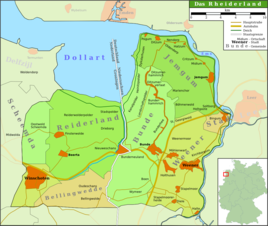
Map of the Rheiderland
|
|
|
Weenermoorer Church
|
|
Weenermoor is a district of the city of Weener in the East Frisian Rheiderland . The place has 347 inhabitants.
Location and area
Weenermoor is a row settlement. It lies northwest of Weener, parallel to the A 31, on slightly elevated ice age, water-permeable mineral soils ( Podsol - Gley soils). To the west of the town there are extensive raised bogs, to the east of which there are moderately fertile, overlooked low bogs. Between Weenermoor and Weener lay the Weener Meer, an inland lake that has now silted up.
history
At the latest in the 13th and 14th centuries (but probably much earlier) the reclamation and settlement by stretching began in Weenermoor . The resulting plots were between 35 and 100 m wide and over time reached a length of up to four kilometers. The place was first mentioned in 1428 as Weninghermoer . A second settlement core developed in the Overmoor . Little is known about this. It is believed that the name is related to flooded areas.
From this time old house squares and the churchyard of the now desolate, medieval predecessor settlements of Weenermoors from the 13th / 14th centuries east of today's village center on Warfen became. Discovered in the 19th century. This settlement had major drainage problems, so it was relocated to its current location in several steps. The ongoing cultivation of the bog also contributed to the relocation of the village to the west. Little by little, the houses in the old village center were demolished and rebuilt further west. Some residents stayed behind. The farms created in this way are not repatriate farms . They are still today Eenhus , Tweehusen and Dreehusen . called. In 1664 Overmoor and Weenigermoor grew together. But a new church was built on Mittelweg in 1660, the location of which was called Strohkarken because of the thatched roof . In spring, the cemetery served as a gathering place for Dutch visitors. In 1815 the church collapsed. To the southwest of its location, today's Weenermoorer Church was laid out in 1824 , completing the relocation of the village. In 1891 Overmoor was incorporated into Weenermoor.
After the Second World War, the place took in an average number of displaced persons for East Frisia .
On January 1, 1973 Weenermoor was incorporated into the city of Weener.
Population development
The district Weenermoor is not congruent with the former municipality.
| year | Residents |
|---|---|
| 1823 | 572 |
| 1848 | 836 |
| 1871 | 797 |
| 1885 | 975 |
| 1905 | 1050 |
| 1925 | 1275 |
| 1933 | 1302 |
| 1946 | 1628 |
| 1950 | 1660 |
| 1956 | 1487 |
| 1961 | 1606 |
| 1970 | 1829 |
| 2009 | 367 |
literature
- Local history working group e. V. Weenermoor - Möhlenwarf - Sankt Georgiwold - Beschotenweg (Ed.): 10 years chronicle of the local history working group e. V. Weenermoor - Möhlenwarf - Sankt Georgiwold - Beschotenweg , self-published, Weener 2005.
Individual evidence
- ↑ a b c d Paul Weßels (local chronicle of the East Frisian landscape): Weenermoor, municipality of Bunde, district of Leer (PDF; 645 kB), accessed on February 3, 2010.
- ↑ a b Local History Working Group e. V., Weenermoor-Möhlenwarf-St. Georgiwold-Beschotenweg: The localities-Sankt Weenermoor , viewed on February 3, 2010.
- ^ Federal Statistical Office (ed.): Historical municipality directory for the Federal Republic of Germany. Name, border and key number changes in municipalities, counties and administrative districts from May 27, 1970 to December 31, 1982 . W. Kohlhammer GmbH, Stuttgart / Mainz 1983, ISBN 3-17-003263-1 , p. 263 .


