Hold
|
Hold
City of Weener
|
|
|---|---|
| Coordinates: 53 ° 6 ′ 33 ″ N , 7 ° 21 ′ 8 ″ E | |
| Height : | 2 m above sea level NN |
| Residents : | 124 (December 31, 2017) |
| Postal code : | 26826 |
|
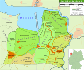
Map of the Rheiderland
|
|
Halt is a district of the city of Weener in the East Frisian Rheiderland . 124 inhabitants lived in the village on December 31, 2012. Mayor is Andreas Silze.
history
The place arose from a Vorwerk of the Johanniterkommende Muhde , who ran a dairy in Halt . The place is first mentioned in a document in 1439 as vorwerke tho Halteren . The name Haltt has come down to us from a map from 1589 . After the Reformation , the property of the Johanniter passed into private hands. Halt thus became a noble estate with the associated rights. There was a brick factory in Halt. Around 1800 the place also served as a stacking place for ships coming from the sea. In the 19th century, a shipyard and a sawmill determined economic life. At the time of the French occupation of East Frisia, Halt was a customs post.

