Holthusen (Weener)
|
Holthusen
City of Weener
Coordinates: 53 ° 9 ′ 37 ″ N , 7 ° 18 ′ 9 ″ E
|
|
|---|---|
| Height : | 2 (–6.90) m above sea level NN |
| Area : | 9.23 km² |
| Residents : | 1129 (December 31, 2017) |
| Population density : | 122 inhabitants / km² |
| Incorporation : | 1st January 1973 |
| Postal code : | 26826 |
|
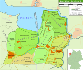
Map of the Rheiderland
|
|
Holthusen is a district of the city of Weener in the East Frisian Rheiderland . 1129 inhabitants lived in the village on December 31, 2017. The mayor is Gerrit Dreesmann.
Geology and geography
Holthusen lies at heights between just below sea level (NN) and 6.9 m above sea level. NHN on a Geestrücke west of Weener, east of the A 31 at the level of the Bunde motorway triangle between Stapelmoor and Beschotenweg . In the west the village borders on a raised bog area, in the north and east on the sandy soils of the Geest with overlying Plaggenesch .
history
Holthusen has been inhabited since the early days. This is indicated by Stone Age artifacts that were discovered in Holthusen. Finds of a bronze ax, which can be interpreted as a Bronze Age bog sacrifice, as well as pottery shards from the Roman Empire and the late Middle Ages make settlement continuity likely. The place was first mentioned in a document in 1472. The name is of Low German origin. Literally translated it means wooden houses, but can also be represented as forest houses. The name indicates the earlier forest in this area. During the Middle Ages Holthusen was part of the Rheiderland and after the consolidation of the county of East Frisia , the Cirksena assigned it to the Weener Bailiwick in the Leerort district . After the occupation of East Frisia by Dutch and later French troops, Holthusen was part of the canton of Jemgum in the arrondissement of Winschoten in the Ems-Occidental département from 1807 . After the defeat of Napoleon, the place was incorporated into the Bailiwick of Stapelmoor in the Weener district in 1817, which was declared a district of Weener in 1885 . Since its dissolution in 1932, Holthusen has been part of the district of Leer.
On January 1, 1973, Holthusen was incorporated into the city of Weener.
Individual evidence
- ↑ Weener.de: Holthusen / Holthuserheide / Tichelwarf , viewed on September 20, 2018.
- ^ Paul Weßels (local chronicle of the East Frisian landscape): Holthusen, Stadt Weener, district of Leer (PDF; 422 kB), accessed on January 14, 2013.
- ^ Federal Statistical Office (ed.): Historical municipality directory for the Federal Republic of Germany. Name, border and key number changes in municipalities, counties and administrative districts from May 27, 1970 to December 31, 1982 . W. Kohlhammer GmbH, Stuttgart and Mainz 1983, ISBN 3-17-003263-1 , p. 263 .


