Kirchborgum
|
Kirchborgum
City of Weener
|
|
|---|---|
| Coordinates: 53 ° 12 ′ 1 ″ N , 7 ° 24 ′ 2 ″ E | |
| Height : | 0.1-4 m above sea level NN |
| Area : | 7.93 km² |
| Residents : | 278 (Dec. 31, 2017) |
| Population density : | 35 inhabitants / km² |
| Incorporation : | 1st January 1973 |
| Postal code : | 26826 |
| Area code : | 04951 |
|
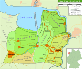
Map of the Rheiderland
|
|
|
Kirchborgum Church
|
|
Kirchborgum is a village and a district of Weener in the Rheiderland , which is located in southwestern East Friesland . The village is located directly on the Ems and on the main road between downtown Weener and the district town of Leer . About 300 people live in Kirchborgum.
history
The first mention of Kirchborgum comes from the 15th century. The original Kirchborgum church from 1638 soon sank into the Ems. The present reformed church was built in 1827 by JB Kröger as a hall church in the style of the classicism of the 19th century. In contrast, the bell tower from 1766 from the previous church was preserved. The brick church is kept simple and provided with pilaster strips and arched windows. The interior is by a wooden barrel vaults, the Biedermeier pulpit and the organ of Gebrüder Rohlfs embossed. The instrument was built in 1876 on the west side with eight voices without an aliquot register on a manual and pedal. For a long time there was a ferry connection across the Ems to Driever in Overledingerland . On January 1, 1973 the village was incorporated into the city of Weener.
Personalities
- Otto Buurman (1890–1967), philologist, doctor and ministerial official in the health sector
literature
- Wilhelm Lange (Hrsg.): The families of the parish Kirchborgum (1724-1900) . Reprint of the 1st edition. Upstalsboom-Gesellschaft, Aurich 2011, ISBN 978-3-934508-39-2 (Ostfriesland Ortssippenbücher, vol. 19; German Ortssippenbücher, vol. A 116).
Individual evidence
- ↑ Gottfried Kiesow: Architectural Guide Ostfriesland. Verlag Deutsche Stiftung Denkmalschutz, Bonn 2010, ISBN 978-3-86795-021-3 , p. 173.
- ^ Walter Kaufmann: The organs of East Frisia . East Frisian Landscape, Aurich 1968, p. 148.
- ^ Federal Statistical Office (ed.): Historical municipality directory for the Federal Republic of Germany. Name, border and key number changes in municipalities, counties and administrative districts from May 27, 1970 to December 31, 1982 . W. Kohlhammer GmbH, Stuttgart / Mainz 1983, ISBN 3-17-003263-1 , p. 263 .


