Dielerheide
|
Dielerheide
City of Weener
|
|
|---|---|
| Coordinates: 53 ° 7 ′ 0 ″ N , 7 ° 16 ′ 0 ″ E | |
| Height : | 2 m above sea level NN |
| Residents : | 177 (December 31, 2017) |
| Postal code : | 26826 |
|
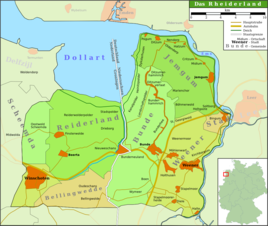
Map of the Rheiderland
|
|
Dielerheide is a district of the city of Weener in the East Frisian Rheiderland . In the place arose as a scattered settlement southwest of Stapelmoorerheide on excavated high moor. It is first mentioned in a document in 1787 as Dieler-Hayde and in 1823 it had 62 inhabitants, spread over eleven houses.
Individual evidence
- ^ Paul Weßels (local chronicle of the East Frisian landscape): Diele, Stadt Weener, district of Leer (PDF; 429 kB), viewed on September 20, 2018.

