Hallway (Weener)
|
Hallway
City of Weener
|
|
|---|---|
| Coordinates: 53 ° 7 ′ 12 ″ N , 7 ° 18 ′ 50 ″ E | |
| Height : | 3 (0.4-7.5) m |
| Area : | 6.63 km² |
| Residents : | 582 (Dec. 31, 2017) |
| Population density : | 88 inhabitants / km² |
| Incorporation : | 1st January 1973 |
| Postal code : | 26826 |
| Area code : | 04951 |
|
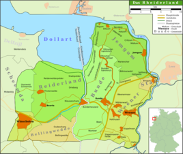
Map of the Rheiderland
|
|
|
380 kV line leading to the substation
|
|
Diele is a district of the town of Weener in the East Frisian Rheiderland . The place was on December 31st. 2017 almost 600 inhabitants. Due to its location on the southern border of the county and the later principality of East Friesland, the place was of great importance in its history. In the immediate vicinity of the village are the remains of the Dieler Schanze , a defense system that was supposed to protect East Friesland from attacks from the Münsterland .
Location and area
The clustered village lies on a ridge that extends in the north to Möhlenwarf and Weener, at a height of 5 m above sea level . In total, the place covers an area of 6.63 square kilometers. Immediately south of the village is the historical border between East Frisia and the Emsland .
The closest larger cities are Leer (about 20 km northeast) and Papenburg (about ten kilometers southeast). The distance to the main town Weener is about five kilometers.
history
Diele is one of the oldest settlements in East Frisia. In 1994 the remains of a Neolithic settlement were discovered. There is evidence of a stone ax found in the early Bronze Age . Subsequently, in the hallway, as in large parts of East Frisia, there was a gap in the settlements until the early Middle Ages. When East Frisia was resettled after the Migration Period, Diele was one of the first places where people settled.
In the Middle Ages, a trade route led from the Münsterland to East Frisia over the high, dry Geestrücke near Diele, which may be of older origin. Up until the early modern era, this route was the only way to get from the Emsland to East Frisia. Diele lay here between a bend in the Ems and a vast area of moorland.
For the first time, the place is mentioned in the records of the monastery in the 9th century as Dilnumarcha . The place name is probably derived from the old Frisian word dele or dile for “teat”, “chest” or “vault”, which is explained by the fact that Diele is located on a top of the Geest that juts out into the Ems valley. Presumably, the construction of the Dieler Schanzen began in the 14th century to protect East Friesland from attacks from the Münsterland . In 1463 and 1632, East Frisia and the diocese of Münster came to a legal agreement on the border at Diele.
When Dutch troops repeatedly moved to East Frisia during the Eighty Years' War in the 16th century , the place acquired a special strategic importance. Since an incursion by Spanish troops was feared, the place was fortified and the entrenchments expanded so that they finally extended over a distance of two kilometers. A total of up to 400 soldiers should be able to be stationed in the fortress. After the war, the importance of the fortress quickly declined. In the 17th century it was temporarily occupied by only seven men. In the following years the hill was occupied several times by foreign troops. From the middle of the 19th century Diele lost a significant part of its population due to a wave of emigration to America. After the Second World War, only relatively few displaced persons were accepted in the place . In 1949 they made up 11 percent of the total population. Four years later it was still 8.6 percent.
A 380 kV substation was built in Diele in the 1970s. In 2008/2009, the first HVDC system equipped with IGBTs in Germany was built west of this system . It is the end point of the HVDC BorWin1 , the world's first HVDC system to connect an offshore wind farm to the power grid.
On January 1, 1973 Diele was incorporated into the city of Weener.
Population development
|
literature
- Working group village chronicle (ed.): Village chronicle Weenermoor - Möhlenwarf - Beschotenweg. Weener 1993.
Individual evidence
- ↑ a b c d e Paul Weßels (local chronicle of the East Frisian landscape): Diele, city of Weener, district of Leer (PDF; 429 kB), viewed September 1, 2012.
- ^ Federal Statistical Office (ed.): Historical municipality directory for the Federal Republic of Germany. Name, border and key number changes in municipalities, counties and administrative districts from May 27, 1970 to December 31, 1982 . W. Kohlhammer, Stuttgart / Mainz 1983, ISBN 3-17-003263-1 , p. 263 .


