Möhlenwarf
|
Möhlenwarf
City of Weener
|
|
|---|---|
| Coordinates: 53 ° 10 ′ 33 ″ N , 7 ° 18 ′ 14 ″ E | |
| Height : | 4 (1.2-4.1) m |
| Area : | 17.59 km² |
| Residents : | 1807 (December 31, 2017) |
| Population density : | 103 inhabitants / km² |
| Postal code : | 26826 |
| Primaries : | 04951, 04953 |
|
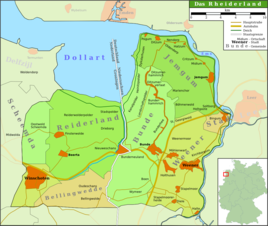
Map of the Rheiderland
|
|
|
Möhlenwarfer Church
|
|
Möhlenwarf is a district of the city of Weener in the East Frisian Rheiderland . The place has almost 1,800 inhabitants.
Location and area
Möhlenwarf is a row settlement. It lies west-northwest of Weener, parallel to the border with Beschotenweg, on slightly elevated, glacial, water-permeable mineral soils ( Podsol - Gley soils). The village extends at a height between 1.2 and 4.1 m above sea level .
history
The settlement of the place began in the 18th century. At first the place was parish after Weener. In 1727 he is mentioned for the first time in Weener's church registers. Möhlenwarf was not, as the place name suggests, on a warf , but on a hilltop of the Geestinsel between Weener and Bunde . The name Möhlen- ( Ostfriesisches Platt : Mühlen ) in the place name comes from a small oatmeal mill that stood in the middle of the farming settlement of five houses. After East Frisia passed to Prussia in 1744, the reclamation of the surrounding moors began. This led to an economic upswing, which was also expressed in the growing population. In 1823 there were 48 fire pits in the village. At this time 170 people lived in Möhlenwarf. In 1848 there were 46 residential buildings and 311 residents. Around the middle of the 19th century Möhlenwarf was connected to the road network by paved paths. This brought more residents to the place. The agriculturally usable parcels became smaller and smaller over time, so that the population became impoverished and was forced to earn their living as workers in the farms of the Rheiderland. It was not until the construction of the Leer-Neuschanz railway line that the economic importance of the town, which was given its own train station in 1876 and used primarily for freight and freight traffic, increased again. The church was consecrated in 1905 . After the Second World War, the importance of rail transport for the place decreased significantly, so that in 1963 the station was closed.
In the course of the municipal reform, the previously independent village became a district of Weener in 1972.
literature
- Local history working group e. V. Weenermoor - Möhlenwarf - Sankt Georgiwold - Beschotenweg (Ed.): 10 years chronicle of the local history working group e. V. Weenermoor - Möhlenwarf - Sankt Georgiwold - Beschotenweg , self-published, Weener 2005.
Individual evidence
- ↑ a b c Paul Weßels (local chronicle of the East Frisian landscape): Weenermoor, municipality of Bunde, district of Leer (PDF; 645 kB), accessed on September 20, 2017.
- ↑ a b Heimatkundlicher Arbeitskreis eV, Weenermoor-Möhlenwarf-St. Georgiwold-Beschotenweg: The localities Möhlenwarf , viewed on February 3, 2010.


