Geise (mud flats)


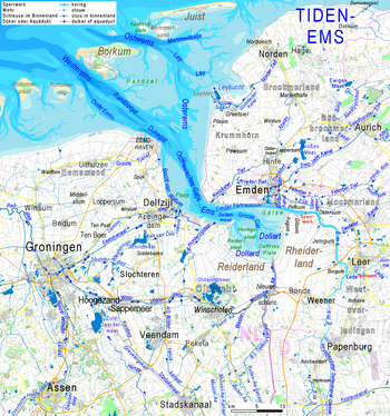
The Geise is a mudflat in the Tidenems . It forms the southern boundary of the flow channel of the Ems, from Emden port also Emden fairway called, and separating it from the tidal creek system- Dollard bay. Its north-south extension measures up to three kilometers. In east-west direction it has a length of about 11 km including the Geisesteert . This mud flap is mostly less than 1 km wide and protrudes from the east almost to the middle of the 5 km long neck of the Outer Em, about 2 km west of the Punt van Reide, the western boundary of the Dollart. The Dollard estuary (the "Dollartmund", ndl .: "Dollardmond") south of the Geisesteert continues eastward into the wide channel of the Groote Gat .
The geise gained its shape under human influence over many years. Since the creation of the Dollart, attempts in vain to prevent the course of the Ems from being shifted to the south by means of a sheet pile wall , but then managed to concentrate the currents near the north bank and thus deepen the now slightly shifted fairway through groynes and a dam hold.
The east of the Geise south of the longitudinal stage, together with the adjacent areas of the Hoogsand and the East Frisian Plate (almost all of the German part of the Dollart) form a quiet zone of the Lower Saxony Wadden Sea National Park . Coordinates: 53 ° 19 ′ 50 ″ N , 7 ° 10 ′ 35 ″ E
swell
- Kadaster (Nederland) - ANWB / VVV Topografische kaart 1: 50,000, no. 4 Groningen East
Web links
- WSA Emden: Relief map of the tidenems → Selection: "Topography"