
Sluis
 flag |
 coat of arms |
| province |
|
| mayor | Marga Vermue-Vermue ( CDA ) |
| Seat of the municipality | Oostburg |
|
Area - land - water |
307.16 km 2 279.36 km 2 27.8 km 2 |
| CBS code | 1714 |
| Residents | 23,323 (Jan 31, 2019) |
| Population density | 76 inhabitants / km 2 |
| Coordinates | 51 ° 20 ′ N , 3 ° 30 ′ E |
| Important traffic route |
|
| prefix | 0117 |
| Postcodes | 3353, 4501, 4503-4508, 4511, 4513, 4515, 4522, 4524-4525, 4527-4529 |
| Website | Homepage of Sluis |
 |
|
Sluis ( ; German Schleuse ) is a municipality in the Dutch province of Zeeland . It forms the westernmost third of Zeeuws Vlaanderen , including 17 km of the North Sea coast . There are 19 urban settlements and villages in the municipality. The total area of the municipality is 307.16 km², its population is 23,323 (as of January 31, 2019).
places
The most important places in the municipality are: Sluis , Aardenburg , Oostburg , Breskens , Cadzand , Eede , Groede , IJzendijke , Nieuwvliet , Schoondijke and Sint Anna ter Muiden .
Sluis was an independent municipality until 1995, which was merged with the municipality of Aardenburg to form the new municipality of Sluis-Aardenburg , whose main town was Aardenburg. In 2003, Sluis-Aardenburg merged with the municipality of Oostburg to form the larger municipality of Sluis.
history


.jpg)

The town of Sluis was formed by a lock in the Zwin , the watercourse that once gave Bruges access to the sea. It received city rights from the Flemish Count Gwijde van Dampierre in 1290 . In the 14th century, Sluis was very important as the outer port of Bruges. In 1340 the first great battle of the Hundred Years War , the Naval Battle of Sluis, took place in the Bay of Sluis , which ended in a catastrophic defeat for France. When Flanders rose up against the Roman-German King Maximilian of Austria in 1492 , Sluis was besieged in vain by Philipp von Kleve-Ravenstein . By 1550 the Zwin was no longer passable. Later a canal was dug Sluis- Damme- Bruges, but the big ships stopped coming to Bruges. The heyday of Sluis was also over.
During the Eighty Years' War it was conquered by the Dutch in 1576, by the Spanish in 1587 and again by Moritz von Nassau in 1604 . The fortress builder Menno van Coehoorn had new bastions and other fortifications built in 1702 , but in 1747 and 1794 the French managed to take Sluis twice.
From 1828 until his death in 1872, Johan Hendrik van Dale, who compiled the Great Dictionary of the Dutch Language , lived in the town . This lexicon is still setting the tone in the Dutch-speaking area. From 1901 the impressionist painter Ernst Oppler lived in Sluis and painted his beach pictures .
During the Second World War , Sluis, like almost all other places in the municipality, was largely destroyed during Operation Switchback (for the purpose of conquering the Scheldt estuary ) in autumn 1944.
Oostburg was a hub for wool between 1000 and 1200 . The old city was completely destroyed in 1944.
Attractions

In the town of Sluis you can take a walk through the fortifications, some of which are well preserved. The town hall (built in 1390, restored in 1951) is the only one in the Netherlands to have a belfry .
Breskens is a small fishing village on the coast, close to the border with Belgium . It offers several large camping and bungalow parks and a sandy beach with long dunes. Breskens is also known for its large number of well-known fish restaurants. A passenger ferry (only for pedestrians, with and without a bicycle) commutes between Vlissingen and Breskens every hour . Furthermore, weekly markets take place regularly in the small town center. Breskens also gains supra-regional importance through its annual fishing festival, which usually takes place in August and attracts thousands of visitors.
Groede with its campsites is a village 1.5 km from the sea. In the center there is a church from the 13th century . During the Second World War , Groede was a Red Cross village and therefore remained undestroyed with its historic town center. Today the winding streets with the houses from the Middle Ages form the so-called "Vlaemsche Erfgoed". Museums or restaurants are housed in various houses so that they can also be visited from the inside.
Nieuwvliet is also an idyllic village. Its historically restored typical windmill is well known . During the season, life mainly takes place in Nieuwvliet-Bad, a district that consists practically only of bungalow parks and campsites.
Eede is right on the Belgian border. It achieved historical fame as the first place where Queen Wilhelmina first set foot on liberated Dutch soil at the end of 1944, a memorial still reminds of it.
Cadzand is perhaps the most famous seaside resort in the municipality. A lot of tourist infrastructure and a wide sandy beach contribute to its popularity. In addition to campsites and bungalow parks, there are also quite a few hotels in Cadzand, some of them in the 4-star category. Cadzand is close to the Belgian border, not far from the Belgian-Dutch nature park Het Zwin , where you can observe the flora and fauna under a guide.
Sint Anna ter Muiden is a small district near the Belgian border. The apparently far too large Reformed Church testifies to the once greater importance of the place.
In Aardenburg , some old houses survived the war damage of 1944. The local history museum is also noteworthy for the archaeological finds. The St. Bavo Church , the construction of which began in 959, is a Gothic church in the so-called Scheldt Gothic style . In the church, one of the most worth seeing in the whole of the Netherlands, there is an exhibition about the restoration in the 1950s with many special features.
Sint Kruis has a reformed church with a massive west tower from the 14th century.
IJzendijke has a market square with a few small houses from the 17th century .
photos

Oostburg, water tower

Groede, church: de Grote Kerk

Schoondijke, church

Aardenburg, orphan house: de Meiboom

Sint Anna ter Muiden, old church tower

Nieuwe Sluis, lighthouse

Cadzand, church: de Mariakerk

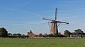
Retranchement, mill: de Retranchementse Molen

Sluis, drawbridge
Zuidzande, mill: de Zuidzandese molen


economy
The main branches of the economy are agriculture and tourism with participating branches (gastronomy and others).
Breskens has a yacht, fishing and industrial port. However, fishing is predominantly of regional importance here. The income is mainly processed and sold in the surrounding towns. In Schoondijke there are several companies for large agricultural equipment and the metalworking industry. There is also a windmill park.
Sluis, Aardenburg and Oostburg are shopping centers, also for visitors from neighboring Belgium . Sluis has a special position here, where the shops are open seven days a week. Since Sluis was formerly a border town, typical goods such as alcohol, cigarettes and cosmetics are still sold tax -free today (similar to duty-free at airports). In Sluis there is also the municipal administration and the town hall / town hall in the old Belfort, the only one in the Netherlands.
Cadzand, Groede and Nieuwvliet-Bad have become tourist centers because of their wide, clean beaches. Accordingly, there are many hotels, campsites and holiday home areas with the associated infrastructure near the coast.
There is a lot of agriculture spread across the municipality : the places in the municipality that are not mentioned are mostly small farming villages.
Basically, the community suffers from increasing emigration of the local population. A lack of training opportunities and few employment opportunities, especially for more highly qualified people, mean that many younger people with or without families move to larger cities.
politics
Distribution of seats in the municipal council
The local elections on March 21, 2018 resulted in the following distribution of seats:
| Political party | Seats | |||
|---|---|---|---|---|
| 2006 | 2010 | 2014 | 2018 | |
| CDA | 3 | 3 | 4th | 4th |
| VVD | 2 | 3 | 3 | 3 |
| Politieke Vereniging Lijst Babijn | 0 | 2 | 2 | 3 |
| Nieuw Gemeentebelang | 6th | 3 | 3 | 3 |
| Dorpsbelangen en Toerisme | 4th | 2 | 3 | 2 |
| PvdA | 4th | 3 | 2 | 2 |
| SP | - | - | 1 | 1 |
| GroenLinks | - | - | - | 1 |
| D66 | - | 1 | 1 | 0 |
| Vereniging Helder Zeeuws | - | 2 | 0 | - |
| total | 19th | 19th | 19th | 19th |
Political structure
The community is divided into the following districts:
| No. | place | Residents |
|---|---|---|
| 00 | Sluis | 2,395 |
| 01 | Retranchement | 330 |
| 02 | Aardenburg | 2,500 |
| 03 | Eede | 885 |
| 04 | Sint Kruis | 225 |
| 05 | Oostburg | 4,735 |
| 06 | Zuidzande | 560 |
| 07 | Cadzand | 735 |
| 08 | Nieuwvliet | 425 |
| 09 | Groede | 975 |
| 10 | Breskens | 4,700 |
| 11 | Hoofdplaat | 860 |
| 12 | IJzendijke | 2,410 |
| 13 | Schoondijke | 1,430 |
| 14th | Waterlandkerkje | 510 |
| local community | 23,658 |
Descriptions of some places
Nieuwvliet and Nieuwvliet-Bad
Nieuwvliet is quiet, idyllic and consists mainly of fields and the “International” campsite. Nieuwvliet has a total of four campsites, a mill, a castle, two independent restaurants (except for camping restaurants or bars) and two leisure facilities. The village is rather small, but some festivals and concerts are played in the pavilion every year . Nieuwvliet-Bad has become more and more of a tourist destination in recent years. Clean beaches, three campsites, shopping streets, swimming pool and a few restaurants, plus a riding hall. All of this is housed in the clearly laid out Nieuwvliet bathroom. Nieuwvliet-Bad is known as a seaside resort for families
Groede
Groede is the neighboring village of Nieuwvliet. The village itself is very small, just like Nieuwvliet, but the land or the area is much larger. Groede has a lighthouse on its beach and also two campsites: “Strand Camping Groede” and “Napoleonhoeve”, to which a public swimming pool is connected. Groede has a maritime museum and flea markets take place every year.
Oostburg
Oostburg is primarily a place for shopping. There are markets here every month, there are various supermarkets and the center consists of a few shopping streets. The place is mainly designed for tourists.
Cadzand
Cadzand is another tourist metropolis and its shopping street is right on the beach. There are several hotels in Cadzand.
Web links
- Website of the municipality (Dutch)
- Van Dale dictionary publisher website (Dutch)
- Illustration by Frans Hogenberg from 1587: Slvys. Gent, Brug and other places more, In Flanders it was very well behaved, The Prince took care of you ... ( digitized version )
- Illustration by Daniel Meisner from 1625: Schleúß. Cupido Et Ira Pessimi Sunt Consultores ( digitized version )
Individual evidence
- ↑ Bevolkingsontwikkeling; regio per maand . In: StatLine . Centraal Bureau voor de Statistiek (Dutch)
- ↑ Contemporary illustration by Frans Hogenberg from 1621: Actual illustration of the starcke Statt Sluys with all their forts ... ( digitized version )
- ↑ Result of the local elections: 2014 2018 ( Memento of the original from April 11, 2018 in the Internet Archive ) Info: The archive link was inserted automatically and not yet checked. Please check the original and archive link according to the instructions and then remove this notice. Gemeente Sluis, accessed April 10, 2018 (Dutch)
- ↑ Allocation of seats in the municipal council: 2006 2010 2014 2018 ( Memento of the original from April 11, 2018 in the Internet Archive ) Info: The archive link was inserted automatically and has not yet been checked. Please check the original and archive link according to the instructions and then remove this notice. , accessed April 10, 2018 (Dutch)
- ↑ Kerncijfers wijken en buurten 2017 Centraal Bureau voor de Statistiek , accessed on April 10, 2018 (Dutch)
Borsele | Goes | Hulst | Chapel | Middelburg | Noord-Beveland | Reimerswaal | Schouwen-Duiveland | Sluis | Terneuzen | Tholen | Veere | Vlissingen