Zeeuws Vlaanderen
 flag |
 coat of arms |
| province |
|
|
Area - land - water |
876.74 km 2 722.45 km 2 145.29 km 2 |
| Residents | 105,533 (May 31, 2018) |
| Coordinates | 51 ° 19 ′ N , 3 ° 48 ′ E |
| Important traffic route |
|
| prefix | 0114, 0115, 0117 |
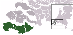
Zeeuws Vlaanderen ( German Zealand Flanders ) is a part of the Netherlands south of the estuary of the Scheldt on the border with the Belgian region of Flanders . Zeeland Flanders mainly borders the Province of East Flanders in the south, but also has contact with the Province of West Flanders .
Today it is the southernmost part of the Dutch province of Zeeland . The area consists of the three communities Terneuzen , Hulst and Sluis . With over 50,000 inhabitants, Terneuzen is the largest city in the province of Zeeland, in front of the capital Middelburg, and has the third largest seaport in the Netherlands.
geography
The area of Zeeuws Vlaanderen has been connected to the northern peninsula of Zuid-Beveland via the Westerschelden tunnel since 2003 . Places important for tourism are z. B. Aardenburg , Breskens , Cadzand and Cadzand-Bad , Nieuwvliet , Oostburg , Retranchement (all belonging to the municipality of Sluis).
The area around Terneuzen in the middle of Zeeuws Vlaanderen originally formed an island that was settled from Axel, a village southeast of Terneuzen, and was therefore influenced by Calvinism . It was only connected to the mainland by dikes. The east (around Hulst) and the west (around Sluis) originally belonged largely to the Flemish mainland, to which they oriented themselves, which is why these areas are Catholic .
history
Historically, Zeeuws Vlaanderen forms part of the County of Flanders , but it was conquered by the troops of the Seven United Provinces and then belonged to the part of the Netherlands ruled by the Seven United Provinces as part of the Generals Land.
At the end of the First World War Belgium intended to annex Zeeuws Vlaanderen and the Dutch province of Limburg (Netherlands) . This was justified by the fact that Dutch neutrality would have favored Germany during the war. As a result, there were large demonstrations in Zeeuws Vlaanderen and in Limburg, as well as in many other places in the Netherlands, for these two parts of the country to remain with the Netherlands. At the Paris Peace Conference in January 1919, Belgium was unable to enforce its demands against the Netherlands.
literature
- Jan JB Kuipers, Robbert Jan Swiers: Het verhaal van Zeeland . Lost, Hilversum 2005, ISBN 90-6550-843-0 .
Web links
- Zeeuws-Vlaanderen: Website of the tourist association VVV Zeeland (Dutch, German, English)
Individual evidence
- ↑ Bevolkingsontwikkeling; regio per maand Centraal Bureau voor de Statistiek , accessed on July 1, 2018 (Dutch)
- ^ Jan JB Kuipers, Robbert Jan Swiers: Het verhaal van Zeeland . Lost, Hilversum 2005, p. 169.
- ↑ Pierre JH Ubachs: Handboek voor de geschiedenis van Limburg . Lost, Hilversum 2000, ISBN 90-6550-097-9 , p. 353.
- ↑ Wilhelmina : Lonely and yet not alone . Evangelisches Verlagswerk, Stuttgart 1961, p. 170.
- ^ Kasper Wagemans: Limburg en het Belgische annexionisme, 1918–1920 . In: Studies over de sociaal-economische geschiedenis van Limburg , Vol. 53 (1999), pp. 89-134.
