
Hulst
 flag |
 coat of arms |
| province |
|
| mayor | Jan-Frans Mulder ( CDA ) |
| Seat of the municipality | Hulst |
|
Area - land - water |
251.82 km 2 201.71 km 2 50.11 km 2 |
| CBS code | 0677 |
| Residents | 27,551 (Jan 31, 2019) |
| Population density | 109 inhabitants / km 2 |
| Coordinates | 51 ° 17 ′ N , 4 ° 2 ′ E |
| Important traffic route |
|
| prefix | 0114 |
| Postcodes | 4543, 4561 |
| Website | Homepage of Hulst |
 |
|
 |
|
Hulst ( ) ( Zeeland and East Flemish Ulst ) is a Dutch municipality in the province of Zeeland and, according to the CBS, had 27,551 inhabitants on January 31, 2019 .
Location and economy
The municipality covers the eastern part of the Zeeuws Vlaanderen region near the Belgian border; the Belgian city of Antwerp is only 22 km away. Hulst describes itself as “the most Flemish city in the Netherlands”.
The road N60, from the new Westerschelden tunnel to the N49 in Belgium (Antwerp - Zelzate - Bruges ) and on to Sint-Niklaas leads in a circle around the town of Hulst.
Trade is flourishing in Hulst. Mail order companies like Neckermann Versand had a branch there. Agriculture and tourism are also important.
history
In 1180 Hulst received city rights from Flemish Count Philip of Alsace . In the Middle Ages , the population of the region was engaged in salt production: peat was dug up, which was salty due to the proximity to the sea; when the peat was burned, the salt remained. Also flax was cultivated among others the present village Heikant, then and now. Hulst developed into an important fortress and port city, where, among other things, sheets were traded.
In the meantime , the village of Clinge had emerged on a small dune , in dialect "kling". In the late Middle Ages there were often disputes between the Counts of Flanders and the large cities there such as Ghent . The Hulsters mostly sided with the Count. At the end of the 15th century, this led to troops from the city of Ghent advancing and occupying Hulst.
Hulst was in the Eighty Years' War initially (with a brief interruption 1591-1595) in the area of the Catholics. The Spanish archduke Albrecht and Isabella provided it with a wall and two advanced works, the forts Liefkenshoëck and Zandberg between 1615 and 1621 . However, the Dutch general Friedrich Heinrich conquered it in 1645 with the siege of Hulst . This resulted in the encirclement and blocking of the Scheldt and Antwerp. The fortress was besieged in 1747 by the troops of the French Marquis de Contades . She capitulated on May 11th.
The economic development of Hulst, as it was strongly directed towards Flanders, was severely affected. When the port was closed in 1795 (the watercourse to the Scheldt was so silted up that no ships could pass through), poverty set in. Only when better roads were built in the 20th century and tourism developed after 1950 did prosperity return.
The village of St. Jansteen was called Sint-Jan ter Steene in the Middle Ages. There was a steen (a stone building, maybe a castle or tower), and the village was a glory until 1795, administered by a baron .
Until the 16th century, the whole region was littered with refuges and “uithoven” (alternative houses or farms) of the great monasteries of Flanders, including Ter Doest. The monks also built similar houses in Hulst itself.
politics
Distribution of seats in the municipal council
The local elections on March 21, 2018 resulted in the following distribution of seats:
| Political party | Seats | |
|---|---|---|
| 2014 | 2018 | |
| Algemeen Belang Groot Hulst | 6th | 7th |
| CDA | 3 | 4th |
| Groot Hontenisse | 3 | 3 |
| HulstPLUS | - | 2 |
| VVD | 1 | 2 |
| PvdA | 3 | 2 |
| SP | 1 | 1 |
| GroenLinks | - | 0 |
| D66 | - | 0 |
| PROGRESSIEF HULST | 3 | 0 |
| HULST DIFFERENT | 1 | - |
| total | 21st | 21st |
Political structure
The community is divided into the following districts:
| No. | place | Residents |
|---|---|---|
| 01 | Hulst | 10,845 |
| 02 | Sint Jansteen | 3.165 |
| 03 | Clings | 2,320 |
| 04 | Greyw | 965 |
| 05 | Tricky | 1,125 |
| 06 | Nieuw names | 1,015 |
| 07 | Kapellebrug | 330 |
| 08 | Kloosterzande | 3,305 |
| 09 | Lamswaarde | 880 |
| 10 | Ter Hole | 475 |
| 11 | Vogelwaarde | 2,090 |
| 12 | Hengstdijk | 540 |
| 13 | Ossenisse | 310 |
| local community | 27,395 |
Town twinning
Attractions

- The three-kilometer-long city fortification dates from the Eighty Years' War. One can stroll around the city over the ramparts. The former Fort Zandberg in front of the city is still present with its complete earth walls.
- One of the sights of the city is the St. Willibrordus Basilica , which was built between 1200 and 1534. The tower of the church was rebuilt after a fire in 1562, also after a fire in 1663, again after 1724 because of its dilapidation and again in 1957 after the war-related destruction in 1944. The church was given the title of basilica in 1935.
- Hulst has a local museum (“De 4 Ambachten”) in an old “refugiehuis” ( refuge , monastic alternative house).
- In the north of the municipality there is the mud flats of the " drowned land of Saeftinghe ", a nature area on the banks of the Scheldt.
- Wooden shoes are still made in Clinge .
photos

Hulst, turn of the basilica (Sint Willibrordusbasiliek)

Hulst, Tor (de Gentse Poort) in the street
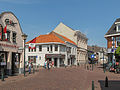
Hulst, street: Gentsestraat

Tricky, church: kerk van de Heilige Theresia van het kindje Jezus

Sint Janssteen, church: de Sint Johannes de Doperkerk

Clinge, church: de Heilige Henricuskerk


Reineke Fuchs

A Dutch version of the verse epic Reineke Fuchs was written at the end of the 12th century under the title " Van den vos Reynaerde ". The town of Hulst is mentioned by name, which the town commemorates with a monument and cultural events.
Daughters and sons of the church
- Cornelis de Vos (1585–1651), painter
- Cesar Bogaert (1910–1988), racing cyclist
- Theo Verschueren (* 1943), Belgian racing cyclist
- Jan Menu (* 1962), jazz musician
- Michel Everaert (* 1963), beach volleyball player
- Jean Paul de Bruijn (* 1965), karamola player
- Eva Buchmann (* 1982), Belgian jazz musician
Web links
- Website of the municipality (Dutch)
- Hulst: Website of the tourist association VVV Zeeland (German, Dutch, English)
Individual evidence
- ↑ Bevolkingsontwikkeling; regio per maand . In: StatLine . Centraal Bureau voor de Statistiek (Dutch)
- ^ Illustration by Frans Hogenberg from 1591: Landt Van Waest. From Arnhem to the land of Waeß, Graff Moritz, who has conquered Hulst without some stupidity, ... ( digitized version )
- ↑ Illustration by Frans Hogenberg from 1596: A strong stat so in Brabant [corrected on the plate:] in Flanderlant, Gelegen is and Hulst called ... ( digitized version ); Illustration by Frans Hogenberg from 1596: The cardinal before Hulst arrives, July 10th with some people ... ( digitized version )
- ↑ Result of the municipal elections in Gemeente Hulst, accessed on April 5, 2018 (Dutch)
- ↑ Allocation of seats in the Gemeente Hulst municipal council , accessed on April 5, 2018 (Dutch)
- ↑ Kerncijfers wijken en buurten 2017 Centraal Bureau voor de Statistiek , accessed on April 17, 2018 (Dutch)
- ↑ for a description of the collection (only available in Dutch): see the municipality's website → Cultuur → Musea
Borsele | Goes | Hulst | Chapel | Middelburg | Noord-Beveland | Reimerswaal | Schouwen-Duiveland | Sluis | Terneuzen | Tholen | Veere | Vlissingen