
IJzendijke
 flag |
 coat of arms |
| province |
|
| local community |
|
|
Area - land - water |
47.08 km 2 46.87 km 2 0.21 km 2 |
| Residents | 2,410 (Jan. 1, 2017) |
| Coordinates | 51 ° 19 ′ N , 3 ° 37 ′ E |
| Important traffic route |
|
| prefix | 0117 |
| Postcodes | 4507-4508, 4513, 4515, 4522, 4553 |
| Website | Homepage of IJzendijke |
 |
|

IJzendijke ( Zeeland - Flemish Iezendieke ) is a district of the municipality Sluis in the Dutch province of Zeeland . In January 2017, 2,410 residents lived in the place.
history
The place was a port city and a trading center in the Middle Ages. It received city rights in 1303. On November 19, 1404, Ijzendijke was swallowed up by the floods during the Elisabethenflut . It was later rebuilt elsewhere. During the Eighty Years' War the Spanish Duke of Parma built a fortress with four bastions on the northwest side of the old town. The fortress was later expanded. IJzendijke was an independent municipality until 1970. Since the municipal reorganization in 2003, the place belongs to the municipality of Sluis.
Attractions
One of the sights of IJzendijke is the market square with some listed buildings, for example the De Witte Juffer windmill from 1841, the church in Kerkstraat 2 from 1612 and the Het Bolwerk Museum voor de Staats Spaanse Linies .
Picture gallery

IJzendijke 1649

Church: de Onze Lieve Vrouwe ten Hemelopnemingskerk
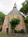
Church, anno 1612

De Witte Juffer windmill

Marketplace
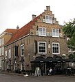
listed house on the market

museum


Web links
- Place website (Dutch)
- IJzendijke: Website of the tourist association VVV Zeeland (German, Dutch, English)
Individual evidence
- ↑ a b Kerncijfers wijken en buurten 2017 Centraal Bureau voor de Statistiek , accessed on April 10, 2018 (Dutch)
- ↑ Deltawerken.com: The St. Elisabeth floods
- ^ History of IJzendijke (NL)
- ^ Website of the Museum Het Bolwerk (Dutch, German, English, French)