
Altenberg on the Rax
|
Altenberg an der Rax ( Rotte ) locality Altenberg cadastral community Altenberg district |
|||
|---|---|---|---|
|
|||
| Basic data | |||
| Pole. District , state | Bruck-Mürzzuschlag (BM), Styria | ||
| Judicial district | Mürzzuschlag | ||
| Pole. local community | Neuberg an der Mürz | ||
| Coordinates | 47 ° 40 '39 " N , 15 ° 38' 39" E | ||
| height | 782 m above sea level A. | ||
| Residents of the village | 250 (January 1, 2020) | ||
| Building status | 153 (addresses 2018 ) | ||
| Area d. KG | 57.65 km² | ||
| Post Code | 8691 chapels | ||
| prefix | + 43/3857 ( Neuberg ) | ||
| Statistical identification | |||
| Locality code | 15910 | ||
| Cadastral parish number | 60501 | ||
| Counting district / district | Altenberg an der Rax (62144 002) | ||
|
Main town of Altenberg [an der Rax] until 2014 Source: STAT : Local directory ; BEV : GEONAM ; GIS-Stmk |
|||

Altenberg an der Rax is a place in the Upper Mürz Valley in Styria as well as - as Altenberg - a locality and cadastral municipality of the municipality of Neuberg an der Mürz in the Bruck-Mürzzuschlag district .
1849-2014 Altenberg formed an independent community . Since then it has been run as a district of the municipality.
geography
Altenberg an der Rax is located about 40 kilometers northeast of Bruck an der Mur , 8 km north of Mürzzuschlag . It is located in the Altenberg valley, a side valley on the upper Mürz near Kapellen . The valley forms the border of the Mürzsteg Alps and the Rax-Schneeberg group . In the west rises the Schneealpe ( 1903 m above sea level ), in the northeast that of the Raxalpe ( 2007 m above sea level ).
Place, locality and cadastral municipality
The Altenberg an der Rax Rotte is 5 km east of Neuberg . It stretches along most of the valley along the Altenberger Bach , at heights of 750 to 800 m above sea level. A.
In addition to the village itself, Altenberg also includes the localities Knappendorf and In der Naß am Altenbergerbach further into the valley, Kerngraben in the side valley towards Rax, and Lohmgraben in the side valley towards Schneealpe, as well as some huts on the Schneealpe. This place has a good 150 addresses with about 260 inhabitants. The Alternberger Erzberg ( 982 m above sea level ) rises directly north of the village .
The Altenberg cadastral community is much more extensive with 5765.5 hectares and an area of 14½ km: It stretches from the Stelzer ( 947 m above sea level ) on the Mürz directly over chapels to the Gamseck ( 1857 m above sea level ) and then on the Rax along the border northward over Naßkamm and Amaißbichl ( 1848 m above sea level. A. ) and around the whole plateau of Schneealpe and the northern foothills to Waxenegg ( 1647 m above sea level. A. ) and over the cross saddle and the Glatzeten Kogel to over on the Grassgraben , and further west the Kalte Mürz out to the place near Neuwald , where Kalte Mürz and Stille Mürz merge to Mürz, already at the foot of Göller and Gippel .
This cadastral area also includes the villages of Greith southwest over the Mürz near Kapellen, and Steinalpl in the far north on the Stillen Mürz.
Altenberg's lowest point is 725 m. The highest point is also the highest point of the Schneealm and is located on the Windberg at 1903 m.
Neighboring locations
|
Steinalpl (O)
Mürzsteg (KG)
Staples (KG) |
∗ | |
.svg)
|
Kohlbachgraben (O Stojen) |
|
|
Stojen (O, KG chapels)
|
- ∗The KG Kapellen extends to the Rax plateau in the north-east of the village: Rax location in the Raxen village; In addition to Naßwald , the village of Graben also includes the Schwarzauer shares in the Rax: Rax plateau location .
Geology and soil science

The region around Altenberg an der Rax is largely shaped by the geology of the limestone Alps and the Grauwackenzone .
The Grauwackenzone under Altenberg was created in the Paleozoic in what is now Antarctica. During this time, the oldest rocks in Altenberg were phyllite and green schist . Porphyroid , a volcanic rock, was formed on top of these layers as another rock of the Grauwackenzone . The Blasseneck porphyroid is traversed by siderite , which penetrated into crevices, cavities and cracks from below in the Paleozoic. Iron ores like this formed the basis for earlier iron ore mining in the region.
Subsequently, in the Mesozoic , deposits built up on the greywacke zone, the later components of the limestone Alps . During these processes Altenberg was at the level of the equator and moving further north. This is how the rocks of the Werfen layers emerged , later the Gutenstein limestone and then the Wetterstein limestone and dolomite . During the mountain formation of the Alps, these rock layers were lifted up. This sequence of layers can still be traced today through stone finds in various places in Altenberg.
At the end of the Old Tertiary, both mountains had already been demolished to form a hilly landscape, which is best preserved as a summit corridor on the plateau mountains of the eastern limestone Alps, such as Rax and Schneealm. During the subsequent ice ages, glacier movements shaped the landscape. All that remains of the glaciers in Altenberg today is unsorted calcareous moraine material .

According to eBod, there are predominantly rock and loose sediment brown soils and mountain black soils in the non-forested area of Altenberg an der Rax . North of the village (coordinates: N 17 ° 41.008 ', E 15 ° 38.074') a soil profile survey was carried out. The soil profile pit was dug in a meadow with a slight slope between two streams, near the Lohmgraben, the exact location being selected after drilling stick probes on the meadow. Using the profile approach, the soil could be classified as carbonate alluvial soil . The following horizons were defined:
- Ah: Humorous, skeletal , intensely rooted A-horizon with a crumbly structure, which indicates the biogenic activity of earthworms.
- C1 and C2: transition horizons that differ in grain size. The layering parallel to the slope results from the deposition of different grain sizes during different flood events. The browning features in the BC2 horizon were caused by weathering of the calcareous starting substrate prior to deposition (ex-situ).
- Cu: Material not involved in soil formation from a lateral moraine .
Probing with the drill stick shows a small-scale interlocking with the soil types of carbonate-containing, brown soil, brown soil and brown soil. The starting material contains a lot of carbonate, the Ah horizon is largely decalcified by the root exudates . The carbonate content increases with the soil depth. The soils are very shallow and rich in skeletons, therefore only suitable for grassland use.
Climate, flora and fauna
Altenberg lies in the climatic region of Upper Mürz Valley . The climate is moderately cold in winter and moderately warm in summer.
In the municipality of Altenberg there is a high degree of botanical biodiversity, especially in the area of the Schneealpe. Particularly noteworthy are the diverse flower meadows and the occurrence of species on the Red List.
Grassland that is easy to manage is mostly used intensively. In steeper or inaccessible locations, on private small meadows in the valley area, very humid locations or peripheral areas, however, species-rich and / or valuable plant communities and species are often to be found. The following selection of grassland vegetation types describe types of these extensive meadows in the Altenberg valley:
- Central European base-rich mowing semi- arid lawn : The water balance is relatively dry, nutrient-poor and base-rich locations that are not fertilized and only mowed or grazed once a year, have a high biodiversity. The area recorded in June 2014 contained 56 species and was therefore the most species-rich record in the vegetation surveys. Type of character is the upright brome ( Bromus erectus ). Furthermore, the loud red list endangered species come [Pigeon Skabiose] ( Scabiosa columbaria ), the Greater Knapweed ( Centaurea scabiosa ) and the kidney vetch ( Anthyllis vulneraria ) ago.
- Fresh, species-rich, greasy meadow in the lowlands or the mountain step: Depending on the exposure and incline, a transition between the lowlands and the mountain step can be seen. On the steep slopes facing south, the common oat ( Arrhenatherum elatius ) and other low-lying indicators such as the Wiesen-Pippau ( Crepis biennis ) dominate. North-facing slopes are e.g. B. shaped by golden oats ( Trisetum flavescens ) or the great star umbel ( Astrantia major ). The different characteristics in the base balance are also reflected in the species composition and v. a. reflected in biodiversity. An average of 42 species were found in soils rich in bases and 32 species in soils poor in bases. In general, the stocks on soils rich in bases are more species-rich. This meadow type is also visually very appealing: for example, [daisies] ( Leucanthemum ircutianum ), meadow goat whiskers ( Tragopogon orientalis ), meadow bellflower ( Campanula patula ) and many other species occur.
In addition to the aforementioned semi-arid grasslands and species-rich meadows, there are also other valuable biotope types that are worthy of protection, such as very small areas of acidic grasslands and small sedge .
The nature conservation rarities of the Altenberg grassland include various orchid species such as the two-leaved forest hyacinth ( Platanthera bifolia ) and the common spotted orchid ( Dactylorhiza maculata ), as well as the red list species fire lily ( Lilium bulbiferum - endangered), yellow lady's slipper ( Cypripedium) calceolus - endangered), marsh stendrums ( Epipactis cf. palustris - endangered), roofed gladiolus ( Gladiolus imbricatus - endangered) and pigeon scabiosa ( Scabiosa columbaria - endangered).
In June 2014 area Altenberg following bat species have been identified by means of acoustic analysis: Eptesicus nilssonii (Northern bat), Pipistrellus pipistrellus (pipistrelle), Nyctalus noctula (Noctule) Myotis myotis (mouse-ear), Vespertilio murinus (Parti-colored Bat), Brandt bat ( Myotis mystacinus and / or Myotis brandtii ), Nyctalus leisleri (noctule bat) and Barbastella barbastellus (pug bat).
Waters
The municipality is located in a spring protection area, the Rax – Schneeberg – Schneealpe water reserve , the springs of the First Vienna High Spring Water Pipeline also arise in the Rax and Schneealpe area.
history

The caves, which are located in the vicinity of Altenberg, were already used by Stone Age hunters as a refuge in prehistoric times ( white lead pit near chapels: spearhead from the last interglacial period, around 183,000 to 118,000 BC). The whole area was then covered by a dense jungle, the Cerewald . Only the peaks of the Rax and the Schneealm were not forested.
A permanent settlement of the valley from Lower Austria probably took place only after the migration of peoples at the beginning of the early Middle Ages. Around 1100 large parts of Altenberg belonged to the domain of the Counts Formbach- Pitten.
The first written mention of Altenberg in Latin was found in a document from 1327. Only after the establishment of the Cistercian monastery of Neuberg by Duke Otto rejoice 1327 the area came gradually into the possession of the monastery, so that by the Ameisbichl today's border came in 1458 from the Mürz about.
The economic boom that the place experienced through the iron mine in the 19th century was reflected in an increase in the population from approx. 300 to 857 in 1880. During this time, an elementary school, initially with one and later two classes, was built (1879). In the years 1892 and 1893 the mine in Altenberg was closed. The mine house, wooded rubble dumps, the name Knappendorf for the northeastern part of the village, the Knappensteig to Neudorf, and the mighty ore chunk on the war memorial are still witnesses of the former mining operation .
As a result of the mine closure and the two world wars (1914-1918 and 1939-1945) there was a decline in population. Nevertheless, there was brisk construction activity, especially after the Second World War, which enabled the number of houses to be doubled. Even before the war, Altenberg was electrified in 1938 by building a low-voltage overhead line to the transformer station in Altenberg. In 1956 and 1965, a local water supply network was laid.
The largest construction project in the Altenberg community was the construction of the canal (1984, 1986) as part of the Upper Mürz Valley wastewater association . Between 1994 and 1997 a new fire station was built on the upper floor.
Former parish
Altenberg [an der Rax] (Former municipality)![Historic coat of arms of Altenberg [an der Rax]](https://de.wikipedia.org/wiki/Datei:Wappenaltenberg.png) |
|
|---|---|
| Basic data | |
| Pole. District , state | Bruck an der Mur (until 1902) / Mürzzuschlag (MZ, until 2013), Styria |
| Judicial district | Mürzzuschlag |
| Coordinates | 47 ° 42 ' N , 15 ° 36' E |
| surface | 57.65 km² |
| Statistical identification | |
| Community code | 61302 |
| Counting district / district | Altenberg an der Rax (61302 000) |
| 1849–2014, then part of Neuberg an der Mürz ; Cadastral municipality: Altenberg an der Rax; Localities: Altenberg an der Rax (main town), Greith , Steinalpl Source: STAT : Local directory ; BEV : GEONAM ; GIS-Stmk |
|
The former tax municipality Altenberg an der Rax became an independent political municipality with the creation of the local municipalities in 1848/49 . It belonged to the Bruck an der Mur district until 1902 , then to the Mürzzuschlag district , and after 2013 briefly to the new Bruck-Mürzzuschlag district. Since 2015 Altenberg an der Rax has been incorporated into the municipality of Neuberg an der Mürz together with the previously independent municipalities of Kapellen and Mürzsteg as part of the Styrian municipal structural reform.
The former municipality corresponds to the cadastral municipality that still exists today, with the localities Altenberg an der Rax , Greith , Steinalpl .
Neighboring communities were last starting from the north in a clockwise direction: in Lower Austria: St. Aegyd am Neuwalde , Schwarzau im Gebirge ; in Styria: Kapellen (Styria) , Neuberg an der Mürz and Mürzsteg .
politics
The municipal council last had 9 members, the distribution of seats since the municipal council election 2010 was 6 ÖVP , 3 SPÖ .
Jakob Holzer (ÖVP) was mayor until December 31, 2014, Werner Stieninger (ÖVP) was deputy mayor.
coat of arms
|
|
Blazon (description of the coat of arms): In a blue shield over a green shield base in the cut of a fir tree top, a silver three-pointed mountain with a raised central peak, covered with a chamois head . |
With the municipality merger, the coat of arms as such became obsolete.
Economy and Infrastructure
The place can be reached from Preinergscheidstraße (L103 / L135) Kapellen - Prein im Schwarzatal on a local road.
The main industry today is tourism. Due to its landscape in the Viennese local mountains and the altitude of 800 meters, and not least because of the lack of any through traffic, Altenberg was awarded the title of recreation village in 1976 . The place is also in the Mürzer Oberland Nature Park, founded in 2003 .
The Schneealm and Rax areas are suitable for mountain tours, hiking, cross-country skiing and Nordic walking, there are also various via ferratas with different levels of difficulty, and guided waterfall climbing. There is also an ice stock rink and an ice rink. The village includes the mountain huts Schneealpenhaus on the Schneealmplateau, Lurgbauerhütte on Ameisbichel (self-catering) and Gamseckerhütte on Gamseck der Rax (the Anton-Zimmermann-Hütte next to it has been closed since 2011).
There is a filling station for e-bikes near the waste material collection center; these can be rented in Mürzzuschlag.
Culture and sights

The townscape with the many historical houses still preserved is remarkable. Some of these are still preserved from the time of mining, such as the mine house, the miner's house and various miners' houses . Numerous houses are framed by floral decorations, as are many public areas.
Buildings
- War memorial: The memorial is located in the center of Altenberg, it forms the second station of the Altenberger Erzberg Montanrundweg . An iron ore stone is mounted on it, which was removed from the mine at Altenberger Erzberg around 1870. It has a weight of around two tons and was originally intended for the World Exhibition in Paris . On the right side of the war memorial there is a limestone, which is typical for the geological shape of the limestone Alps.
- Groschenlochbrunnen on the village square
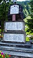
War memorial

Limestone at the war memorial


Museums and nature trails

.JPG)
- Mining Museum Montanarum: The museum was opened on March 27, 2015 and is located in an outbuilding of the Altenbergerhof. It shows relics of mining history from the 18th and 19th centuries: surveying instruments, tools, pit lamps, miner's clothing, pit plans, photos, documents, everyday objects, minerals, etc. The information ranges from iron ore mined in Altenberg to the Neuberg ironworks and the products made there.
- Montanrundweg Altenberger Erzberg: An approximately two kilometer long educational trail along the traces of mining in Altenberg, which leads from the center via historical sites to various relics: historic houses, heaps, tunnels and pings. From the starting point at the signal bowl at the Groschenlochbrunnen on the village square, the circular route leads over the war memorial, through the Knappendorf to the Alternberger Erzberg and back to the starting point. The path is open all year round and takes about 1½ hours.
- Aquazelle Altenberg On the water adventure hiking trail along a stream in Lohmgraben , the interaction between water and rock, flora and fauna is explained. The function of the place as a spring protection area is taken up and thematized through the nature trail, a spring and spring room are visible. The 200 year old Lurgbauer mill, a Kneipp area and an interactive flood simulation are also on the way. Accessible from May to October, walking time 1½ to 2 hours.
- Habitat hedge and ecological nature trail: The two paths deal with ecological and individual hedge trees. A landscaped pond offers amphibians, birds and aquatic plants a suitable habitat. Accessible all year round, takes about 30 to 45 minutes.
- Forest of the senses: Sensory adventure trail a little outside the village center, such as balancing beams, barefoot parcours or scented beds. Open from May to October; chargeable.
Events
- International water forum 1997–2001 of the association Die Steirische Wasserstraße
literature
- Erwin Gruber: From iron ore to water - history Altenberg / Rax . Self-published, 2007, with supplement CD with audio documents.
Web links
Individual evidence
- ^ R. Schuster, A. Daurer, HG Krenmayr, M. Linner, GW Mandl, G. Pestal, JM Reitner: Rocky Austria - Geology of Austria - short and colorful . 3. Edition. Federal Geological Institute, Vienna 2013, ISBN 978-3-85316-066-4 , p. 80 .
- ↑ Digital soil map of Austria ( Memento of the original from June 11, 2016 in the Internet Archive ) Info: The archive link has been inserted automatically and has not yet been checked. Please check the original and archive link according to the instructions and then remove this notice. , accessed June 21, 2014.
- ↑ according to the new nomenclature since 2002 only: brown earths. Announcements of the Austrian Soil Science Society: Key to determining the soils of Austria. 2002
- ^ Taken according to the method of the Swiss botanist Braun-Blanquet (1964); The naming of the biotope types was made according to the biotope type catalog of the Province of Styria: H. Kirchmeir, Ch. Keusch, St. Lieb, M. Jungmeier: Mapping guidelines for biotope mapping Styria , Version 1.2 of January 25, 2008. Processing: ECO Institute for Ecology. On behalf of: Office of the Styrian Provincial Government, Department 13C Nature Conservation.
- ↑ H. Niklfeld: Red Lists of threatened plants Austria . 1st edition. Federal Ministry f. Health and environmental protection, Vienna 1986-
- ↑ Oliver Gebhardt, Coordination Office for Bat Protection and Research in Austria, onA
- ↑ Species inventory of Altenberg's bats (pdf, Wikimedia file).
- ↑ Announcement of the Styrian state government of November 21, 2013 about the unification of the market community Neuberg an der Mürz and the communities Altenberg an der Rax, Kapellen and Altenberg an der Rax, all political district Bruck-Mürzzuschlag. Styrian Provincial Law Gazette of December 6, 2013. No. 148, 35th issue. ZDB ID 705127-x . P. 680.
- ↑ State Law Gazette Styria No. 88/2007 . (pdf, ris.bka)
- ↑ Montanrundweg Altenberger Erzberg - Theme Trail of the Year 2014. ( Memento of the original from August 7, 2018 in the Internet Archive ) Info: The archive link has been inserted automatically and has not yet been checked. Please check the original and archive link according to the instructions and then remove this notice. Mürzer Oberland Nature Park (muerzeroberland.at; accessed March 16, 2018).
- ↑ Water adventure hiking trail - Aquazelle Altenberg. ( Memento of the original from October 16, 2017 in the Internet Archive ) Info: The archive link was inserted automatically and has not yet been checked. Please check the original and archive link according to the instructions and then remove this notice. Mürzer Oberland Nature Park (muerzeroberland.at; accessed March 16, 2018).
- ↑ Habitat hedge - ecological educational park Altenberg / Rax. ( Memento of the original from August 7, 2018 in the Internet Archive ) Info: The archive link was inserted automatically and has not yet been checked. Please check the original and archive link according to the instructions and then remove this notice. Mürzer Oberland Nature Park (muerzeroberland.at; accessed March 16, 2018).
-
↑ Forest of the Senses - Thematic Trail of the Year 2014. ( Memento of the original from August 7, 2018 in the Internet Archive ) Info: The archive link was automatically inserted and has not yet been checked. Please check the original and archive link according to the instructions and then remove this notice. Mürzer Oberland Nature Park (muerzeroberland.at; accessed March 16, 2018);
wald-der-sinne.com .

Cadastral communities: Altenberg | Frein an der Mürz | Chapels | Staples | Mürzsteg | Neuberg
Districts (municipality structure) : Altenberg an der Rax | Chapels | Mürzsteg | Neuberg an der Mürz
Locations: Alpl | Altenberg | Arzbach | Dobrein | Village | Dürrenthal | Frein an der Mürz | Greith | Kaltenbach | Chapels | Staples | Lanau | Lechen | Mürzsteg | Neudörfl | Niederalpl | Raxen | Stake | Steinalpl | Bumpers | Tebrine | Veitschbach
Market place: Neuberg an der Mürz | Villages: Alpl • Chapels • Krampen • Mürzsteg • Neudörfl | Hamlet: Hinterleitner | Mitterbachstall • Rotten: Altenberg an der Rax • Dobrein • Frein an der Mürz • Gschwandt • Hirschbach • Kaltenbach • Karlgraben • Knappendorf • Lanau • Niederalpl • Schlapfen | Settlement: Lichtenbachsiedlung | Scattered houses: Arzbach • Bärntal • Dietlergraben • Dürrenthal • Greith • Kerngraben • Kohlbachgraben • Koglergraben • Lechen • In der Naß • Lohmgraben • Mitterbach • Preiner Gscheid • Rax • Raxen • Schneealpe • Scheiterboden • Steinalpl • Stojen • Tebrin • Tirol • Veitschbach • Tebrin • Tirol • Veitschbach Waldbach | Other locations: Auhof • Donaulandhütte • Eisernes Törl • Gamsecker Hütte • Hinteralm • Mürzsteg hunting lodge • Karl-Ludwig-Haus • Lurgbauerhütte • Michlbauerhütte • Raxkircherl • Reisstalerhütte • Schneealpenhaus • Waxriegelhaus • Wiener teachers hut • Zimmermannhütte • Cistercian monastery Neuberg
Counting district: Alpl-Dorf | Alpl village area | Altenberg an der Rax | Chapels | Mürzsteg
Former communities: Altenberg an der Rax 1850–2014 | Chapels 1850–2014 | Mürzsteg 1850-2014